Comprehensive Development Plan - Vision Document March 2021 DRAFT - Jack's Point
←
→
Page content transcription
If your browser does not render page correctly, please read the page content below
Comprehensive Development Plan
Vision Document March 2021

DRAFT
Contents
           DOCUMENT OBJECTIVE                                            3   3.1 / VISON PRINCIPLES AND OBJECTIVES                                   25

           SECTION 1 / INTRODUCTION                                      6   3.2.1 / MIXED USE PRECINCT                                              29

           1.1 / INTRODUCTION                                           7    3.2.2 / RESIDENTIAL PRECINCT                                            30

           1.2 / CONTEXT                                                8    3.2.3 / VISITOR ACCOMMODATION PRECINCT                                  31

           1.3 / HISTORY                                                9    3.2.4 / COMMUNITY FACILITIES                                            32

           1.4 / CLIMATE, LANDFORM, VIEW ANALYSIS                       10   3.2.5 / EXISTING COMMUNITY OPEN SPACE NETWORK                           33

           SECTION 2 / SUMMARY                                          12   3.2.6 / VILLAGE GREEN AND BLUE SPACE NETWORK                            34

           2.1 / PLANNING HISTORY                                       14   3.2.7 / ACTIVE OPEN SPACE FRAMEWORK                                     35

           2.2 / DISTRICT PLAN REVIEW PROCESS                           15   3.2.8 / EXISTING AND PROPOSED BLUE NETWORK                              36

           2.3 / PROPOSED COMPREHENSIVE DEVELOPMENT PLAN                16   3.2.9 / DEDICATED PEDESTRIAN PATH NETWORK                               38

           2.4 / LAND USE PRECINCT — MASTERPLAN                         17   3.2.10 / DEDICATED CYCLE NETWORK                                        39

           2.5 / PROPOSED COMPREHENSIVE DEVELOPMENT PLAN AREA SUMMARY   18   3.2.11 / ROAD NETWORK HIERARCHY                                         40

           2.6 / SUMMARY OF ACTIVITIES ALLOWED IN THE VILLAGE           19   3.3.1 / ILLUSTRATIVE SITE PLAN — CLUBHOUSE SURROUNDINGS                 41

           2.7 / COMPARISION OF EXISTING VILLAGE VS PROPOSED CDP        20   3.3.2 / ILLUSTRATIVE CROSS SECTIONS                                     42

           2.8 / EXISTING VILLAGE AND EDUCATION ZONE                    21   3.4 / REFERENCE IMAGERY                                                 44

           2.9 / PROPOSED COMPREHENSIVE DEVELOPMENT PLAN                22   SECTION 4 / KEY VILLAGE METRICS AND STATISTICS                          47

           SECTION 3 / THE VISION                                       23   4.0 / KEY VILLAGE METRICS AND STATISTICS                                48

                                                                                                                                    JACK’S POINT VILL AGE
                                                                                                                                    CDP VISION DOCUMENT
                                                                                                                                    DR AF T
                                                                                                                                    MARCH 2021

                                                                                                                                    2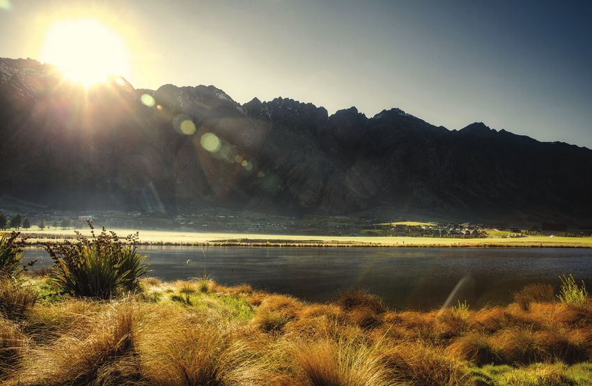
Document Objective
The following document aims to explain the Vision for Jack’s Point Village and provide
further supporting information to the Comprehensive Development Plan (CDP)
framework. From the raw physical attributes of the site to the detailed site planning
and overall design philosophy and principles. It seeks to outline the clear underlying
logic to the Comprehensive Development Plan, its land-use precincts, open space, and
landscape, and how it will interact and provide for the community.

                                                                                         JACK’S POINT VILL AGE
                                                                                         CDP VISION DOCUMENT
                                                                                         DR AF T
                                                                                         MARCH 2021

                                                                                         3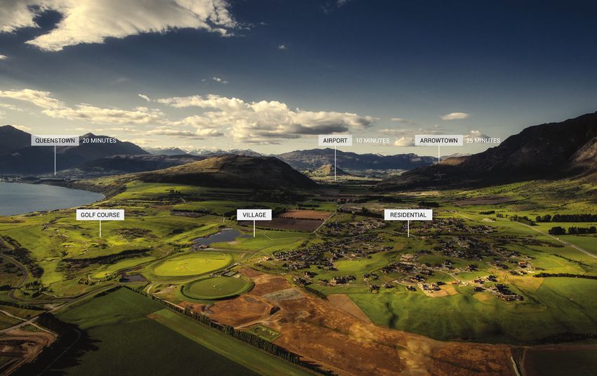
JACK’S POINT VILL AGE
CDP VISION DOCUMENT
DR AF T
MARCH 2021

4
VILLAGE COMPREHENSIVE
DEVELOPMENT PLAN AREA

                        JACK’S POINT VILL AGE
                        CDP VISION DOCUMENT

                        MARCH 2021

                        5
Section 1 / Introduction
Comprehensive Development Plan

                                 JACK’S POINT VILL AGE
                                 CDP VISION DOCUMENT
                                 DR AF T
                                 MARCH 2021

                                 6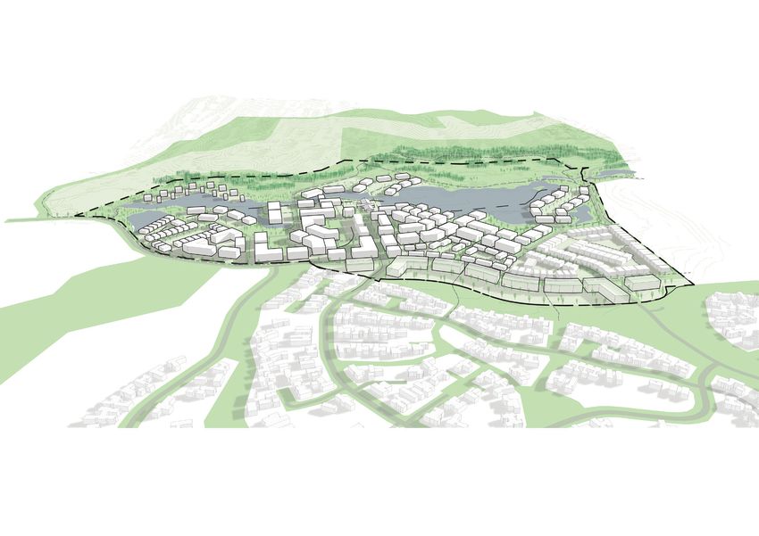
1.1 / Introduction
The Village has been a key element to Jack’s Point settlement plan since its conception and its adoption in 2002 as
a special zone in the Queenstown Lakes District Plan.

The Village will form the vibrant heart of our growing community and provide a central hub for a range of activities
catering to the everyday needs of locals and visitors alike. It will be a place to live, to work, to stay, to learn, to relax
and connect.

The Village has been comprehensively planned to ensure activities and built form respect its special landscape
setting by careful integration within a wider framework of connected green and blue open space and network of
trails.

Key Qualities of a successful Village are an intimate, cohesive environment; with an integrated and inclusive mix of
housing types, sizes, and households, enclosed pedestrian-scale streetscapes with active edges, a varied high-
quality design which respects and enhances the materiality and landscape treatments found already within Jack’s
Point. The Village should provide a “rural-urban” lifestyle and level of convenience that retains strong connections
to the natural, open environment that Jack’s Point sits within.

                                                                                                                                JACK’S POINT VILL AGE
                                                                                                                                CDP VISION DOCUMENT
                                                                                                                                DR AF T
                                                                                                                                MARCH 2021

                                                                                                                                7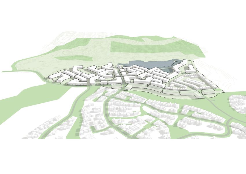
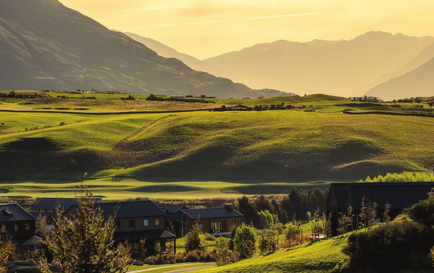
1.2 / Context
Queenstown is New Zealand’s fastest-growing region with approximately 5% annual growth. Its opportunity for
future growth areas is challenged by lack of flat and easy contouring land and the dominance of Outstanding
Natural Landscape Categorisations in the region, meaning well-resolved site analysis and planning is required to
enable appropriate development to be approved.

The Jack’s Point Area, which encompasses approximately 1200 ha (3000 acres) and sits at the foot of the
Remarkables, was identified back in 1992 as a future potential settlement area to accommodate the region’s
growth.

Jack’s Point has become the centre of a rapidly growing community (approximately 6000 dwellings are planned for
the immediate contextual area outside of Jack’s Point).

Jack’s Point is situated in the Wakatipu Basin, approximately 14kms east of Queenstown, New Zealand’s major
destination resort town. The land area is defined by the Remarkables Mountain Range to the east, Lake Wakatipu to
the west and farmland to the north and south.

Jack’s Point is conveniently located less than 9kms from Queenstown International Airport, only 2kms from the
Remarkables Ski Area turnoff and 30kms from Coronet Peak Ski Area.

                                                                                                                    JACK’S POINT VILL AGE
                                                                                                                    CDP VISION DOCUMENT
                                                                                                                    DR AF T
                                                                                                                    MARCH 2021

                                                                                                                    8
1.3 / History
High Country Farming                                                                                                   Jack Tewa
Towards the end of January 1860, a party set out from Dunedin to penetrate the relatively unexplored central region    Jack’s Point is thought to have been named in memory of a 19th Century Maori local named Jack Tewa, who saved
of Otago in search of suitable pastoral lands. They made their way inland via the Waitaki River and the Lindis Pass.   the life of a visiting Englishman when the boat they were in capsized during a squall. The Englishman, unable to
After making an extremely hazardous and costly crossing of the Clutha River and many disappointments in their          swim, clung to the upturned keel but in the freezing cold of Lake
search, only two of the party decided to continue – W G Rees and N P B von Tunzelman.
                                                                                                                       Wakatipu lost his hold and drifted away. Jack swam after him, repeatedly dived beneath the waves to, cut away the
By 1862 Rees had acquired the ‘Shotover’, the ‘Bucklerburn’, the ‘Staircase’ and the ‘Peninsula’ Runs, a huge          halyards, righted the boat, put the Englishman in it and brought the craft, still half-submerged to the shore. There
pastoral empire.                                                                                                       he carried the near-frozen man to higher ground. Fearing that the cold would take them both, Jack set off in the
                                                                                                                       dark for help.
In 1862 gold was discovered in the Shotover and Arrow rivers. Rees moved his pastoral activities from the Shotover
Run to his southern Runs. The Staircase and Shotover Runs were combined and named Kawarau Falls by Rees.               Help was more than 30 miles away and all feared the Englishman would be dead. Yet they found him alive; lying
                                                                                                                       upon him was a large collie dog whose warmth throughout the night had kept him alive. The dog which had
In 1865 Kawarau Falls Station was sold to Charles Crofton Boyes and Frank Campbell Boyes.                              disappeared as a puppy had appeared from the brush and covered his shivering body.

In the years that were to follow Kawarau Station, through boundary adjustments and sales, gradually became             When the rescuers arrived, it leapt up and vanished as mysteriously as it had come. Maori Jack Tewa was awarded
reduced in size to 46,600 acres and having passed through a succession of ownerships, was purchased on the             the Royal Humane Society medal in 1863 for his act of heroism.
14th September 1922 by Dickson Jardine.
                                                                                                                       By then he had also discovered one of the world’s richest gold strikes, nearby on the Arrow River. The point directly
On the 19th September 1941 Dickson took his two sons, Grieve T and Dickson G, into partnership, with farm              opposite where Maori Jack and the collie saved the Englishman became known as Jack’s Point. Over the years
management being undertaken by Dickson G.                                                                              map-makers dropped the apostrophe: We have added the apostrophe back in! Jack’s Point. It remains and will
                                                                                                                       remain as it was, in perpetuity.
In 1947 Dickson subdivided the property between his sons, the necessary documents being signed at the
Homestead 17th February 1948. In the subdivision, Grieve took over the freehold Homestead Block and name of
Kawarau Falls and Dickson G the leasehold hill country and part freehold which he named.

Remarkables Station
In 1960 Grieve sold Kawarau Falls to Frank Mee and the Homestead block to the Methodist Church.

In 1966 Dickson G purchased the adjoining farm known as McAdam’s. Another small adjoining Run known as Loch
Linnhe came up for sale and was purchased by Dickson G for his older son Dickson S. The Land Board approved
the sale subject to a substantial portion of the Station leasehold being amalgamated with the smaller property. The
decision was taken in 1974 to dispose of the Loch Linnhe property and further develop the remaining land.

In 1973 Dickson G took his two sons Dickson S and Andrew G into partnership in Remarkables Station and
eventually the property was subdivided between them, Dickson S taking the leasehold hill country and part of the
freehold, including

McAdam’s Farm and Remarkables Homestead, and retaining the name Remarkables Station. Andrew G took the
balance of the Freehold, which included the original Remarkables Homestead and, named his property Henley
Downs.

In 1999 Dickson S Jardine sold 420 hectares (1000 acres) to Jack’s Point Limited as a future new settlement.

                                                                                                                                                                                                                           JACK’S POINT VILL AGE
                                                                                                                                                                                                                           CDP VISION DOCUMENT
                                                                                                                                                                                                                           DR AF T
                                                                                                                                                                                                                           MARCH 2021

                                                                                                                                                                                                                           9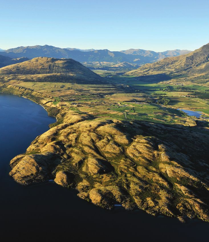
1.4 / Climate, Landform, View Analysis
Climate
Very high sunshine totals are recorded during summer, with an average of over 220 hours per month from
November to February, equating to 75% of the maximum possible. The area is one of the sunniest in the South
Island over summer.

Winds from the west and south move down the arms of Lake Wakatipu and then pass over the basin. The existing
trees and natural landform provide a high degree of shelter from these winds.

This data has been obtained from the nearest climatological station to Jack’s Point, located some 9kms to the
south-west at Queenstown Airport. The mean annual rainfall for the site between 1871 and 2003 was 834.9mm.
There is a tendency for monthly totals of rainfall to be greater in Autumn (March to May) and Spring (September
and October) but this is highly variable from year to year.

The Wakatipu Basin experiences warm summer and cold winters. During the height, Summer temperatures can
rise to high 20’s and in winter fall below -5c.

Landform
The site, due to its significant size, has a complex and varied geology and topography. Repeated glacial erosion
has shaped the valley into the landforms we see today. This has left us with the rolling terrain comprised of glacial
gravels to the east and the schist ridge to the west, where the majority of the golf course has been located.

The village site is located in the central valley, with a flat subtle topography which slopes toward the west to Lake
Tewa, a man-made lake at the centre of Jack’s Point. It is comprised primarily of old beach deposits and glacial
gravels and is ideal for settlement or development.

View Analysis
Jack’s Point is blessed with a panorama of views in all directions. It was determined early on in the planning that
these would be extremely important in the site planning of the village. The view rose (attached) shows the variety of
views available within the site.

The key axis for the site planning was Cecil Peak. The village entry road aligns on this axis, etching into the guest’s
memory, on arrival or departure, the grandeur of their surroundings.

The Remarkables is such an important and recognizable mountain-scape in Queenstown to both local and visitor
alike. It has an omnipresent quality, a quality that changes depending on season and time of day.

                                                                                                                          JACK’S POINT VILL AGE
                                                                                                                          CDP VISION DOCUMENT
                                                                                                                          DR AF T
                                                                                                                          MARCH 2021

                                                                                                                          10
NORTH - EAST THE REMARKABLES SOUTH - EAST
CORONET PEAK NORTH
NORTH - EAST
CECIL PEAK SOUTH - WEST
JACK’S POINT VILL AGE
CDP VISION DOCUMENT
DR AF T
MARCH 2021
11Section 2 / Summary
Comprehensive Development Plan
JACK’S POINT VILL AGE
CDP VISION DOCUMENT
DR AF T
MARCH 2021
12THE PLAN CALLS FOR THE CREATION OF
SIGNIFICANT AREAS OF OPEN SPACE WITHIN
AND AROUND VILLAGE PRECINCTS.
JACK’S POINT VILL AGE
CDP VISION DOCUMENT
DR AF T
MARCH 2021
132.1 / Planning History
The Village has been a key element to Jack’s Point settlement plan since its conception, Then, under new ownership, Henley Downs sought to establish a separate zone that provided for significant
increase in residential capacity and reduction of protected open space areas and design controls. This rezoning
its approval dates back to 2002 when the initial zoning of Jack’s Point as a special zone process and the subsequent District Plan Review saw the Village Activity Area on Henley Farm being changed to
in the Queenstown Lakes District Plan. residential, and 7.00ha of the Driving Range within Jack’s Point being incorporated into the Structure Plan as an
Education Activity Area, to accommodate the requirement for a proposed new school, among other village related
This provided for a total of 28.95ha of Village Activity Area, allowing for a range of activities from Visitor activities.
Accommodation, Residential, and Retail / Hospitality within a total site coverage of 17.37ha. The neighbouring
property Henley Farm, under separate ownership to Jack’s Point, was also included in the Jack’s Point Zone, The Ministry of Education did not proceed with a school within the education area, instead acquiring 3.00ha of
such that (13.88ha) of the Village Activity Area was located on their immediately adjoining land, with the balance residential land within Hanley’s Farm at a considerably greater cost.
(15.07ha) remaining on Jack’s Point land – where the Village is located today.
This therefore left the Jack’s Point Zone with an 18.70ha Village Zone, and a 7.00ha Education zone approved in the
Development of both Villages were planned to occur in an integrated manner, as the residential settlement grew. District Plan, able to be developed today.
Existing Village and Education Area Summary
Existing Title Boundaries
QLDC — Decisions Version Structure Plan
Activity Areas (areas within which development can occur)
Village Activity Area V(JP) = 18.70ha
Education Activity Area (E) = 7.00ha
TOTAL = 25.70ha
V(JP) Site Coverage: (60%) = 11.22ha
Within the Jacks Point Village JP(V) and the Homestead Bay V(HB) Activity Areas maximum building
coverage, calculated across the total activity area, shall not exceed 60%
(E) Site Coverage: (45% net) = 3.15ha theoretical
On any site within the (E) Activity Area, buildings shall not exceed a maximum site coverage of 45%
Total Approved Site Coverage = 14.35ha
There are no further restrictions on the area/scale of landuses that can occur within the Village, and
no provision of dedicated community open space.
JACK’S POINT VILL AGE
CDP VISION DOCUMENT
DR AF T
MARCH 2021
142.2 / District Plan Review Process
The District Plan Review process provided the opportunity to finally achieve one well
planned and integrated Village, based on one overall Comprehensive Development Plan.
Jack’s Point has been actively involved in this District Plan Review (DPR) that commenced in 2015. This process
has proceeded through formal submissions, hearings, and release of the Commissioner’s decision.
That decision among other matters, required the Village be developed in accordance with a Comprehensive
Development Plan (CDP) to be prepared for the Village and incorporated into the Jacks Point Zone within the
Queenstown Lakes District Plan. While Jacks Point supports the idea of a Comprehensive Development Plan ,it
strongly believes it should truly be comprehensive and extend over all Village development activity areas set within
a strong framework of protected green and blue open space and trail networks – aligning the Village with the rest
of Jack’s Point. The existing Village and Education Zone does not allow for a comprehensive planning approach.
Furthermore, the Commissioner’s decision that a Comprehensive Development Plan be included in the District Plan
but be introduced at some later date by a new Plan Change was of concern as this would create a further delay of
several years while development of the Village continues, but on a piecemeal as opposed comprehensive basis.
Accordingly, Jacks Point lodged an appeal to the Environment Court to resolve these matters.
During the Environment Court Hearing held in September 2020, Jacks Point submitted a draft Comprehensive
Development plan that sought to address and solve our matters of concern with the Commissioners decision.
In order to more fully consider the draft CDP and its incorporation into the District plan sooner than later, the
Environment Court directed Jacks Point to undertake the first step of that process by consulting with the Jacks
Point community and other interested parties.
JACK’S POINT VILL AGE
CDP VISION DOCUMENT
DR AF T
MARCH 2021
152.3 / Proposed Comprehensive Development Plan
The Jack’s Point Village Comprehensive Development plan aims to create a vibrant, Key benefits of the CDP are:
cohesive environment; with an integrated and inclusive mix of housing types, sizes and y Provision of approximately 10.00ha of new dedicated community open space on the western edge of Lake
households, enclosed pedestrian scale streetscapes with active edges, a varied high- Tewa, providing direct community access to the lake which would not exist under the currently approved village
plans.
quality design which respects and enhances the materiality and landscape treatments
found already within Jack’s Point. y Provision of a connected network of further Village open spaces (village green, plaza, parks).
The Village should provide for an urban living set within nature and a level of convenience that retains strong y Provision of a further 5km (approx.) of pedestrian and cycle links, providing access to and through the Village
connections to the natural, open environment that Jack’s Point sits within. connecting to the wider trails network. This includes access to a commuter trail network being explored to
connect to Frankton.
The purpose of the Comprehensive Development Plan is to:
y Creation of a Village Beech Forest for amenity and further enhancing the existing vegetation framework of
y Provide a clear vision for the future of Jack’s Point Village. Jack’s Point.
y Provide the mechanism to encourage high-quality urban design outcomes throughout the Jacks Point Village y Creation of additional lake space, increasing amenity and opportunities for water-based recreation.
y Establish an integrated and coordinated framework of connected green and blue open space. y Creation of spaces dedicated to community facilities.
y Locate land use precincts in areas that best allow for the successful integration of the resulting built forms with y Designation of land-use precincts, key pedestrian, and cycle links, providing surety around the location and
the valued natural character of the ‘ ‘Village’s setting. scale of built form, access (pedestrian, cycle and vehicular) and open spaces. Forever enshrining the benefits
listed above for future generations.
y Set clear urban design principles and a framework to establish design controls against which development
proposals requiring resource consent will be assessed. y Creation of inclusive, varied in scale and typology, residential environments within the Village creating
opportunities for live, work, play.
y Provision of commercial and retail activities to the Jack’s Point Community, providing a level of convenience not
currently available in the area.
y Continuation of the vision and environment (both built and landscape) that has been created at Jack’s Point –
through the conception and implementation of the Jack’s Point Village Design Guidelines.
JACK’S POINT VILL AGE
CDP VISION DOCUMENT
DR AF T
MARCH 2021
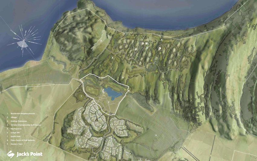
162.4 / Land Use Precinct — Masterplan
JACK’S POINT VILL AGE
CDP VISION DOCUMENT
MARCH 2021
172.5 / Proposed Comprehensive Development Plan Area Summary
The proposed Village Comprehensive Development Plan area is a
total of 49.00ha, and can be further described as:
PROPOSED CDP AREA
CDP – LANDUSE PRECINCTS 19.00 HA
CDP – OPEN SPACE (INCLUDING STREETSCAPES ETC) 30.00 HA
TOTAL 49.00 HA
Land uses within the CDP Area are designated by precincts
ensuring that uses are in locations that are complimentary to one
another, providing for:
CDP PRECINCTS AREA
MIXED USE 6.40 HA
RESIDENTIAL 5.00 HA
VISITOR ACCOMMODATION 6.60 HA
COMMUNITY ACTIVITIES 1.00 HA
VILLAGE OPEN SPACE 30.00 HA
TOTAL 49.00 HA
The CDP allows for a total site coverage of 12.00ha.
JACK’S POINT VILL AGE
CDP VISION DOCUMENT
DR AF T
MARCH 2021
182.6 / Summary of Activities allowed in the Village
Activities that are anticipated to be allowed for within each landuse
precinct are listed below:
Mixed Use Precinct Residential Precinct Open Space Precinct
The Mixed-use Precinct provides for the following activities: The Residential precinct provides for the following activities: The Open Space precinct provides for the following activities:
• Visitor Accommodation • Residential Activity • Recreation Amenities
• Residential Visitor Accommodation • Playgrounds
• Homestays Community Facilities Precinct • Landscaping
• Retirement Villages • Roads, Vehicle Access, and Parking
The Community precinct provides for the following activities:
• Retail Activities located at ground floor level within the areas • Street Furniture
• Health
illustrated as Ground Floor Retail Frontage on the Ground Floor Retail
• EV Charging Stations
Frontage Plan. • Welfare
• Facilities in support of Pedestrian, Cycle Trails, and Laneways
• Within Mixed Use Area M-9 Commercial activity is restricted to • Safety
retailing with no limitation on the maximum net floor area to allow for
• Lighting
a supermarket. • Education
• Stormwater Retention
• Community Activities • Cultural and Spiritual Wellbeing
• Underground Services
• Commercial Activities • Day Care Facilities
• Technology and Innovation based businesses. • Hospitals
• Doctors Surgeries and other Health Professionals
• Halls
Visitor Accommodation Precinct • Libraries
The Visitor Accommodation precinct provides for the following activities:
• Community Centres
• Visitor Accommodation
• Police Purposes
• Residential Visitor Accommodation
• Fire Stations
• Homestays
• Retirement Villages
• Premises for the sale and consumption of food and beverages
provided they do not exceed 400m2 of Public Area
JACK’S POINT VILL AGE
CDP VISION DOCUMENT
DR AF T
MARCH 2021
192.7 / Comparision of Existing Village vs Proposed CDP
Open Space Site Coverage Open Space Site Coverage
11.35ha 14.35ha 30.00ha 12.00ha
Existing Village and Education Zone Comprehensive Development Plan
Site Coverage Landuse Area Open Space
Existing Village and Education Zone 14.34ha 25.70ha 11.35ha
Comprehensive Development Plan 12.00ha 19.00ha 30.00ha
0 10 20 30 40 50 60 70
CDP V&E CDP V&E
11.35ha 14.35ha 30.00ha 12.00ha
Site Coverage Comparision Open Space
JACK’S POINT VILL AGE
CDP VISION DOCUMENT
DR AF T
MARCH 2021
202.8 / Existing Village and Education Zone
Indicative Site Coverage Illustration
Golf Community Open Space
Education Zone Village Zone
Hanley’s Farm
Residential
Community
Sports Field
e
is
oint R
M
ao
ri
sP
Ja
ck
ck
Mc A
Ro
Ja ad
da
D
m
ri
ve
JACK’S POINT VILL AGE
CDP VISION DOCUMENT
MARCH 2021
212.9 / Proposed Comprehensive Development Plan
Indicative Site Coverage Illustration
Golf Community Open Space
Village Comprehensive
Development Area
Hanley’s Farm
Residential
Community
Sports Field
e
is
oint R
M
ao
ri
sP
Ja
ck
ck
Mc A
Ro
Ja ad
da
D
m
ri
ve
JACK’S POINT VILL AGE
CDP VISION DOCUMENT
MARCH 2021
22Section 3 / The Vision
Comprehensive Development Plan
JACK’S POINT VILL AGE
CDP VISION DOCUMENT
DR AF T
MARCH 2021
23RE-INTRODUCTION OF NATIVE BEECH
FOREST, TO PROVIDE A STRONG NATURAL
FRAMEWORK FOR THE INTEGRATION OF
BUILDINGS INTO THE NATURAL LANDSCAPE
SETTING OF THE VILLAGE.
JACK’S POINT VILL AGE
CDP VISION DOCUMENT
DR AF T
MARCH 2021
243.1 / Vison Principles and Objectives
FOUR KEY PRINCIPLES HAVE GUIDED THE SPATIAL AND
WRITTEN FRAMEWORK OF JACK’S POINT VILLAGE.
The Village will form the vibrant heart of our growing community
and provide a central hub for a range of activities catering to the
everyday needs of locals and visitors alike. It will be a place to
live, to work, to stay, to learn, to relax and connect.
AMENITY
Key Qualities of a successful Village are an intimate, cohesive environment; with
an integrated and inclusive mix of housing types, sizes, and households, enclosed
pedestrian scale streetscapes with active edges, varied high quality design which
respects and enhances the materiality and landscape treatments found already
STAINABILITY
within Jack’s Point.
CON
The Village should provide for urban style living set within nature and a level of
NECTIVIT
convenience that retains strong connections to the natural, open environment that
Jack’s Point sits within.
The Village has been comprehensively planned to ensure activities and built
SU
form respect its special landscape setting by careful integration within a wider
Y
framework of connected green and blue open space and network of trails.
CHA
R ACTER
JACK’S POINT VILL AGE
CDP VISION DOCUMENT
DR AF T
MARCH 2021
253.1 / Vison Principles and Objectives
The Village is supported and enforced by the following Principles and Objectives.
Amenity Connectivity
AMENITY AMENITY
To ensure the existing valued natural character of the To create pedestrian-focused, safe, efficient, and well-
village setting is protected or enhanced by appropriate connected village environment, the circulation network
design solutions. should provide a wide range of transportation (outside of
STAINABILITY
STAINABILITY
the motor-vehicle) options and experiences that provide
CON
CON
Objectives linkages to the wider open space network.
NECTIVIT
NECTIVIT
y Provide a strong framework of blue and green spaces Objectives
within which built form can be appropriately located.
SU
SU
Y
Y
y Creation of new trail connections within the Village
y Create attractive, connected nodes of blue and green to provide connectivity with the adjacent ‘Jack’s
CHA
R ACTER
space to encourage a range of different activities and CHA
R ACTER Point Neighbourhoods, open spaces, and the wider
uses. Wakatipu Basin. Trail connections should provide for
multiple means of non-vehicular related transport
y Create sheltered and sunny public spaces through the (bikes, pedestrian, electric carts, and boats etc).
appropriate location and articulation of built forms.
y Create a pedestrian-focused environment with
y Protect or enhance key view shafts to the wider permeable development blocks that provide for
landscape through the appropriate alignment of connectivity and a sense of discovery throughout the
roads, siting of public spaces and suitable building Village.
design.
y Enhance access and interaction on and around Lake
Tewa and connected waterbodies.
y Provide an efficient Vehicle network through the
Village without impacting the pedestrian environment.
JACK’S POINT VILL AGE
CDP VISION DOCUMENT
DR AF T
MARCH 2021
263.1 / Vison Principles and Objectives
Character Environment
AMENITY AMENITY
Create a Village character that reflects its unique To ensure that the natural and built environment is both
mountain setting and celebrates the history and protected and enhanced. Development should promote
architectural traditions of the site and wider district. and encourage appropriate design solutions to ensure it
STAINABILITY
STAINABILITY
The built form and landscape treatment of open spaces is sympathetic to the surrounding environment.
CON
CON
should reflect both the natural and cultural values of its
NECTIVIT
NECTIVIT
wider setting. Evolve and maintain a common design Objectives
language through the careful and considered use of raw,
natural materials and unity of built forms, building on that y Ensure that the water quality of Lake Tewa is
SU
SU
Y
Y
which is already present within Jack’s Point. protected. Protect the existing night-time ambience
through the promotion of low-level light solutions.
CHA
R ACTER Objectives CHA
R ACTER
y Promote the use of sustainable materials and green
y Create a unique pedestrian-friendly waterfront engineering systems throughout the built environment
built environment, providing a diverse range of through the Design Guidelines.
experiences and outdoor activities that encourage
interaction with Lake Tewa. y Outline a direction to ensure the minimisation of
passenger vehicle movement within the Village,
y Outside of the waterfront-built environment, protect through appropriate, efficient roading networks,
and enhance the natural character of the lake hierarchy, and design.
foreshore.
y The support of green building techniques within the
y Create a range of sheltered and sunny public spaces Design Guidelines encouraging cleverly designed
that cater for both the needs of residents and visitors spaces to allow solar gain, maximise airtightness
alike. of the building envelope, natural ventilation and
increased insulation contribute to energy conservation
y Provide for a higher degree of visual and physical and a healthy and comfortable living environment.
permeability between buildings and open space built
forms in and around key public open spaces by the
careful siting and density of adjoining built forms.
y Provide for a diverse range of land use activities
within the Village to offer a high level of convenience,
lifestyle and employment options with a focus living,
visiting and, learning, local employment, well-being
and recreation.
y Provide for cohesive and concentrated retail area
within the Mixed-Use precinct such as the ”Village
Main Street” that caters to both the existing and
future requirements of the wider local community and
visitors.
y Provide land dedicated to meeting community needs
and supporting infrastructure.
y Medium to high-density residential accommodation.
JACK’S POINT VILL AGE
CDP VISION DOCUMENT
DR AF T
MARCH 2021
27THE EXPANSION OF LAKE TEWA PROVIDING
ADDITIONAL AMENITY AND RECREATION
OPPORTUNITIES TO THE VILLAGE.
JACK’S POINT VILL AGE
CDP VISION DOCUMENT
DR AF T
MARCH 2021
283.2.1 / Mixed Use Precinct
The Mixed-Use Precinct will create the vibrant heart of the Village
focused around the main retail precinct at the centre of the Village,
aiming to build on the already high quality of life at Jack’s Point.
Through the use of varied architectural typologies (location, materiality, scale, and form), the
Mixed-Use Precinct will read as a collection of buildings avoiding monotonous, large built
form to emphasise a Village character. Laneways, green links, and connections will feed
people between sheltered courtyards and community spaces.
The mixed-use precinct will also provide for a range of food and beverage offerings, located
along laneways and plaza’s, and the waterfront. Café’s, Restaurants and Bars will be
encouraged to be of a small scale and that reflect the character and requirements of the
Jack’s Point community.
A key aspect of the mixed-use precinct is live, work, play. Residential use is encouraged to
be located above offices and businesses to further reduce the requirement for vehicular
movements and provide a higher level of convenience. This also importantly applies to the
people already living in Jack’s Point.
Servicing the growing community through
a Village core of mixed-use development
offering opportunities for live, work and play.
JACK’S POINT VILL AGE
CDP VISION DOCUMENT
DR AF T
MARCH 2021
293.2.2 / Residential Precinct
The Residential precinct aims to create a permanent resident
population within the Village.
Located on the periphery, the residential precincts are connected to the centre of the village
through the provision of a series of interwoven trails and bicycle and pedestrian-friendly
street networks. Providing a variety of scales and typologies that supports an inclusive
living environment. From medium density housing located in nature, single-family plots, to
social clusters of residences, through to higher density terraced / apartment living set within
landscaped precincts.
Residential development will be focused around communal landscaped spaces with direct
connections to trails and non-vehicular movement opportunities promoting a shift away
from reliance on cars.
Ensuring permanent activity within the
Village, and providing for a range of living
environments, ensuring inclusivity, rather
than exclusivity.
JACK’S POINT VILL AGE
CDP VISION DOCUMENT
DR AF T
MARCH 2021
303.2.3 / Visitor Accommodation Precinct
The Visitor Accommodation precinct aims to provide a diverse range of
lodging types to reflect a rapidly changing and evolving marketplace.
By providing a broad mix of visitor accommodation opportunities, ensuring that it is an
inclusive, rather than exclusive environment for visitors whilst also providing for opportunities
for lodging within each season. From single hotel rooms within the dedicated hotel’s to
individual rooms within the mixed-use precinct to cabins, boatsheds and ‘residences’
integrated into nature and located sensitively along the edge of Lake Tewa.
y Higher density visitor accommodation is located centrally within the village, to the south
of the clubhouse just off of the Village Square, to assist in the activation of the heart of
the village, encouraging interaction of visitors and locals where a more urban ‘village’
experience is desired.
y Less dense areas of visitor accommodation are dispersed along the southwestern arm of
the Village, integrated into nature. Located on the public trail network, this enables visitors
to easily interact with the village and the rest of Jack’s Point should they desire.
y Locating these areas away from the core local part of the village allows for privacy,
seclusion, and a more nature-focused stay. Separating a large amount of servicing
activities away from the village centre, minimising disturbance/impact on the more
populated areas of the village.
From single hotel rooms within the dedicated hotel’s to
individual rooms within the mixed-use precinct to cabins,
boatsheds and ‘residences’ integrated into nature and located
sensitively along the edge of Lake Tewa.
JACK’S POINT VILL AGE
CDP VISION DOCUMENT
DR AF T
MARCH 2021
313.2.4 / Community Activities
The community precinct has been located on a primary road to ensure it has efficient
access and is easily accessible to both the residential neighbourhoods and the Village. The
community activities area will also provide for a logical location for a future transport hub
within the Village in addition to the public transport network proposed.
In order to ensure that the community has provision for facilities such as:
y Emergency Services
y Community Buildings
y Education Facilities
y Health Facilities
ACTIVITIES
Providing for community needs, such as
learning, health and community buildings.
JACK’S POINT VILL AGE
CDP VISION DOCUMENT
DR AF T
MARCH 2021
323.2.5 / Existing Community Open Space Network
Disconnected and fragmented Connected and integrated areas
areas of community open space of community open space woven
disconnected from the Village and through Jack’s Point Village.
Residential Neighbourhoods. Provision of approximately 10.00ha
of dedicated community open space.
JACK’S POINT VILL AGE
CDP VISION DOCUMENT
DR AF T
MARCH 2021
333.2.6 / Village Green and Blue Space Network
Connected Green and Blue Spaces providing for Connected Green and Blue Spaces providing for
a range of different experiences and activities a range of different experiences and activities
throughout the Village. throughout the Village, including a vibrant main
street environment, and Village Green.
JACK’S POINT VILL AGE
CDP VISION DOCUMENT
DR AF T
MARCH 2021
343.2.7 / Active Open Space Framework
Open Space Network
The Village Open space network aims to better connect areas of existing community
open space through the creation of a new dedicated open space network.
Village Square
Located directly adjacent to the Clubhouse, the Village Square will be a key destination
and meeting space within the Village. Providing a space for congregating. From the
Village Square, locals and visitors will be able to meander through to the main street,
connect out to the vast trail networks and lake.
Village Boardwalk
Connecting the arrival square to the Village Green the boardwalk will provide direct
interaction with the lake, meandering through and around the built form. It will offer
spaces for relaxing, access into buildings, and views to the surrounding mountains,
lake, and open space. Terraces and beaches will lead users down to the lake.
Village Harbour Green
The centrepiece of the Village open space network, the Village Harbour and Green,
sheltered by the surrounding buildings will provide for uses such as;
y A beach, for relaxation on long summers days.
y A jetty to launch small sailboats, kayaks, or swimming.
y Terraced Lawn areas for lounging and socialising.
Uses surrounding the Village Harbour / Green will range from Restaurants, Bars, Cafés
to activate the space.
Village Common and Waterfront Park
Access to the Village Common will be via the pedestrian and cycle network through the
Village. The Village Common intends to provide a green border to the Village directly
fronting Lake Tewa that is dedicated to the community, protected and secured for
future generations. This space will provide for interaction with the lake and create the
experience of feeling surrounded by nature with native planting, open grass areas for
recreation.
Enclosed by the Village Beech Forest rehabilitation project to the west uses for this
space may include, small fruit tree orchards, greenhouses, a jetty, pump track, spaces
for undertaking yoga and other recreational / wellbeing focused activities. The Village
Common will also provide spaces for events to be held such as small concerts and
festivals. The Waterfront Park is associated with the Village Common and is connected
via the trails network through and around the Visitor Accommodation precincts.
JACK’S POINT VILL AGE
CDP VISION DOCUMENT
DR AF T
MARCH 2021
353.2.8 / Existing and Proposed Blue Network
Lake Tewa
The centrepiece of the Village, Lake Tewa is proposed to be increased and enhanced through
the creation of additional blue space. Adding to the amenity, of the surrounding areas,
movement opportunities. The trail networks provide loops around the water bodies, allowing
for enjoyment of the lake in its entirety whilst providing a range of different experiences along
the way.
Village Park and Wetland
A key function of the Village Park and Wetlands is to provide protection and enhancement of
the water quality of Lake Tewa. Wetlands will provide detention, filtration and treatment of
runoff from roads and development areas. Boardwalks will connect across these wetlands
to small areas of open space to service the surrounding precincts.
Increased area of Lake Tewa, increasing amenity and
opportunities for water based recreation.
JACK’S POINT VILL AGE
CDP VISION DOCUMENT
DR AF T
MARCH 2021
36THE SPATIAL PLANNING OF THE VILLAGE NOW
PROVIDES FOR PRECINCTS OF LANDUSE ACTIVITIES
CONNECTED BY A NETWORK OF PEDESTRIAN AND
CYCLE TRAILS, AS OPPOSED TO ROADS.
JACK’S POINT VILL AGE
CDP VISION DOCUMENT
DR AF T
MARCH 2021
373.2.9 / Dedicated Pedestrian Path Network
To provide alternate means of getting around the Village and its open
space network, a dedicated trail and cycle network is proposed. This
will greatly enhance and connects to the already established network of
trails throughout Jack’s Point.
Cycleways will be separated from motor vehicle movement where possible by buffers of
vegetation and landscaping.
The trail network will consist of, boardwalks, hard-surfaced trails such as concrete, gravel/
chip, or understated mown tracks into the vast areas of brown top grassland located
throughout the open space network.
A series of loops have been created, to ensure the efficiency of movement around, and
through the village. A connection to a commuter trail (Southern Corridor Study) that directly
connects to Frankton is being provided for and is subject to further planning and discussion
with other landowners in the catchment.
Adding approximately 5km to the existing Trail Network,
creating a series of Village Loops and enhancing
connection to the existing trails at Jack’s Point.
JACK’S POINT VILL AGE
CDP VISION DOCUMENT
DR AF T
MARCH 2021
383.2.10 / Dedicated Cycle Network
To provide alternate means of getting around the Village and its open
space network, a dedicated trail and cycle network is proposed. This
will greatly enhance and connects to the already established network of
trails throughout Jack’s Point.
Cycleways will be separated from motor vehicle movement where possible by buffers of
vegetation and landscaping.
The trail network will consist of, boardwalks, hard-surfaced trails such as concrete, gravel/
chip, or understated mown tracks into the vast areas of brown top grassland located
throughout the open space network.
A series of loops have been created, to ensure the efficiency of movement around, and
through the village. A connection to a commuter trail (Southern Corridor Study) that directly
connects to Frankton is being provided for and is subject to further planning and discussion
with other landowners in the catchment.
A dedicated cycle network, connected to main centres
such as Frankton in Future. Providing alternate means of
transport
JACK’S POINT VILL AGE
CDP VISION DOCUMENT
DR AF T
MARCH 2021
393.2.11 / Road Network Hierarchy
Public Transport Network
The Village will add to the existing public transport network at Jack’s Point through the
provision of an additional bus link conveniently located centrally within the Village.
Vehicular Movement Network
Designed around the prioritisation of pedestrian and cycle movement, the vehicular network
focuses on moving vehicles through the mixed-use precinct, to provide activation of key
frontages whilst being set back from the lake edge, to preserve this for public enjoyment.
Shared Streets (with the ability to be fully closed at certain times) will still enable efficient
circulation, whilst retaining focus on pedestrian and cycle movement.
Electric Vehicle Charging Points will be provided along the primary road corridor.
An efficient roading network, removing vehicles from
the waterfront areas, ensuring a pedestrian dominated
environment. Vehicle connections provided to
surrounding residential populations.
JACK’S POINT VILL AGE
CDP VISION DOCUMENT
DR AF T
MARCH 2021
403.3.1 / Illustrative Site Plan — Clubhouse Surroundings
Existing Clubhouse
Boardwalk connection to Village
Common
Village Common
Village Square
Pontoon
Village Boardwalk
LAKE TEWA
Connection to Village Green
Village Piazza
Village ‘Main Street’
JACK’S POINT VILL AGE
CDP VISION DOCUMENT
DR AF T
MARCH 2021
413.3.2 / Illustrative Cross Sections
JACK’S POINT VILL AGE
CDP VISION DOCUMENT
DR AF T
MARCH 2021
423.3.2 / Illustrative Cross Sections
JACK’S POINT VILL AGE
CDP VISION DOCUMENT
DR AF T
MARCH 2021
433.4 / Reference Imagery
Reference Image - Village Market. Credit - Snohetta
Reference Image - Varied Built Form, Waterfront, Nature. Credit - Henning Larsen
JACK’S POINT VILL AGE
CDP VISION DOCUMENT
DR AF T
MARCH 2021
443.4 / Reference Imagery
Reference Image - Wetland and Boardwalk - Village integrated with nature. Credit - Henning Larsen. Reference Image - Village Streetscape and Residential. Credit - Effekt.
JACK’S POINT VILL AGE
CDP VISION DOCUMENT
DR AF T
MARCH 2021
453.4 / Reference Imagery
JACK’S POINT VILL AGE
CDP VISION DOCUMENT
DR AF T
MARCH 2021
46Section 4 / Key Village Metrics and Statistics
Comprehensive Development Plan
JACK’S POINT VILL AGE
CDP VISION DOCUMENT
DR AF T
MARCH 2021
474.0 / Key Village Metrics and Statistics
Existing Village
The following section aims to provide 175,210 m2 ESTIMATED GFAS
EXISTING VILLAGE (V+E) CDP
CDP
supporting metrics and statistics of the 152,714 m2 VISITOR ACCOMMODATION 53,589 M2 67,583 M2
Comprehensive Development Plan.
RESIDENTIAL 27,171 M2 25,985 M2
Comparisons are provided between the MIXED USE
existing Village and Education Area, and RESIDENTIAL 31,048 M2 29,630 M2
Proposed Comprehensive Development
RETAIL/F&B 15,043 M2 9,131 M2
Plan, so that the impact / change on the
COMMERCIAL 14,159 M2 14,630 M2
existing area can be accurately assessed.
COMMUNITY/EDUCATION (CDP) — 5,755 M2
Estimated GFAs
Open space Maintenance Costs TERTIARY EDUCATION & PRIVATE ACADEMY 34,200 M2 —
The estimated cost associated with the additional open Existing Village
space proposed within the CDP is $105,000 per annum. 3,552
TOTAL 175,210 M2 152,714 M2
The additional open space area would represents an
approximately 20% increase in the current landscape
CDP
maintenance budget for the Jack’s Point residential ESTIMATED DAILY POPULATION EXISTING VILLAGE (V+E) CDP
neighborhoods. 2,030
MIXED USE 655 608
VISITOR ACCOMMODATION 721 827
RESIDENTIAL 326 395
COMMUNITY/EDUCATION (CDP) 200
Estimated Daily Population
TERTIARY EDUCATION & PRIVATE ACADEMY 1,850
Existing Village
11,112 TOTAL 3,552 2,030
ESTIMATED TRAFFIC GENERATION EXISTING VILLAGE (V+E) CDP
CDP
9,269 DAILY EXTERNAL TRIP GENERATION 11,112 9,269
REQUIRED PARKING AREA* 6.4 HA 3.2 HA
*PARKING GENERATED TO BE ACCOMMODATED WITHIN THE APPLICABLE LOT
Estimated Daily External Trip
Generation
JACK’S POINT VILL AGE
CDP VISION DOCUMENT
DR AF T
MARCH 2021
48www.jackspoint.com
You can also read