Continental and marine surficial water - groundwater interactions: the case of the southern coastland of Venice (Italy) - PIAHS
←
→
Page content transcription
If your browser does not render page correctly, please read the page content below
Innovative water resources management – understanding and balancing interactions between humankind and nature
Proc. IAHS, 379, 387–392, 2018
https://doi.org/10.5194/piahs-379-387-2018                                                                           Open Access
© Author(s) 2018. This work is distributed under
the Creative Commons Attribution 4.0 License.

           Continental and marine surficial water – groundwater
                  interactions: the case of the southern
                        coastland of Venice (Italy)
               Luigi Tosi1 , Cristina Da Lio1 , Pietro Teatini1,2 , Antonio Menghini3 , and Andrea Viezzoli3
                          1 Instituteof Marine Sciences – National Research Council, Venezia, Italy
          2 Department   of Civil, Environmental and Architectural Engineering, University of Padova, Padova, Italy
                                          3 Aarhus Geophysics Aps, Aarhus, Denmark

                                    Correspondence: Luigi Tosi (luigi.tosi@ismar.cnr.it)

              Received: 30 December 2017 – Revised: 1 March 2018 – Accepted: 7 March 2018 – Published: 5 June 2018

       Abstract. Understanding the continental-marine surficial water–groundwater exchanges in transitional coastal
       environments is really challenging at large scale. It requires an image of the saltwater–freshwater relationship
       which is difficult to be obtained especially in wetlands, lagoons, and marine areas. This study is focused on
       the coastland of the southern Venice lagoon – northern Po river delta (Italy), a precarious environment subject
       to both natural changes and anthropogenic pressures. Here, saltwater severely affects farmlands and aquifers.
       We used an airborne electromagnetics (AEM) survey with the goal of characterizing the continental and marine
       surficial water–groundwater interactions in such coastal region. The AEM survey allowed depicting a clear image
       of the fresh water–saltwater occurrence in shallow aquifers along mainland-lagoon – littoral-sea profiles, up to
       20 km long. The results reveal that continental groundwater is located in the lagoon subsoil below a 10–20 m
       thick saline aquifer and extends down to 70 m depth. The whole low-lying farmland located south of the lagoon
       margin is seriously affected by saltwater contamination, which occurs from a few to about 50 m depth. The
       integrated analysis of AEM, seismic and borehole data shows that buried morpho-geological structures, such as
       paleo-channels and over-consolidated clay units control the saline contamination from the lagoon and the sea
       into the coastal aquifer system.

1   Introduction                                                  groundwater interaction, i.e. salt-freshwater exchange, in a
                                                                  unique, consistent, and homogeneous framework is still a
Transitional coastal environments have drawn much attention       challenge. Borehole electrical conductivity measurements,
in the last decades because of the high ecological relevance      vertical electric soundings, electrical resistivity tomography,
of deltas, estuaries, lagoons, and wetlands with an increas-      and time-domain electromagnetic investigations are usually
ing concern on their vulnerability, especially in view of the     performed to characterize the saline interface and its evo-
expected global changes.                                          lution in coastlands. Direct measurements such as seepage
   The coexistence of agricultural, urban, and industrial ar-     meters, benthic chambers, and surface water enrichments in
eas with salt- and fresh-water wetlands makes the surface         natural isotopic tracers are often done to assess submarine
water–groundwater exchanges be impacted by both natural           groundwater discharge (SGD) in wetlands, lagoons and off-
processes and human activities. Whilst the exchange of water      shore. Nevertheless, a clear and comprehensive image of the
among rivers, wetlands, lagoons and sea is fairly well under-     mainland-lagoon – sea hydrogeology in a continuous frame-
stood at the local scale, the interactions between these wa-      work is far from being achieved because inland and offshore
ters and the on-shore and off-shore aquifers are often hard to    surveys are generally carried out separately and by differ-
be understood in such complex coastal environments. There-        ent methodologies. In addition, in-depth and extent investi-
fore, investigating continental and marine surficial water–

Published by Copernicus Publications on behalf of the International Association of Hydrological Sciences.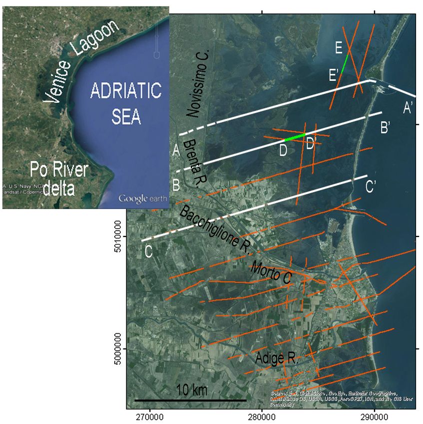
388 L. Tosi et al.: Continental and marine surficial water
ical of the ground-based surveys, among all, the “simultane-
ity” of data acquisition. This method has been successfully
tested in the Venice lagoon at local scale (Viezzoli et al.,
2010; Teatini et al., 2011) and in this work we explored its
potentiality for large scale analysis.
2 Method
About 200 km-long AEM resistivity sections were acquired
by the SkyTEM system in 2013 over the Venice coastland.
This instrumentation was chosen as its dual moment provides
a bandwidth (i.e. a penetration range) suitable for applica-
tions where near-surface and deep information is important
to refine the hydrogeologic model (Viezzoli et al., 2010; Tea-
tini et al., 2011). The AEM survey was acquired along North-
South and West-East profiles, crossing the farmland and wa-
tercourses in a continuous and like-simultaneous acquisition
(Fig. 1). Data have been processed to eliminate artefacts and
assign noise levels at late times, stacked to increase signal to
noise ratio while preserving lateral resolution, and inverted
using the Spatially Constrained Inversion (SCI) technique
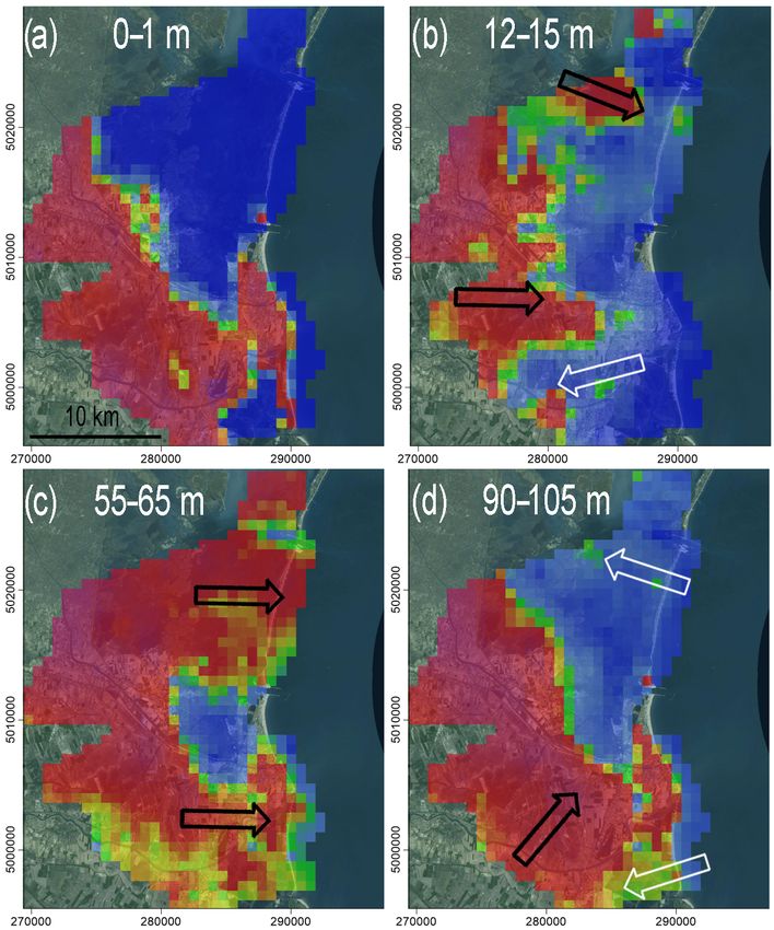
Figure 1. Satellite images of the southern Venice Lagoon – north-
(Viezzoli et al., 2010). The accuracy of the resistivity model
ern Po River Delta coastland. Red and white lines show the AEM
acquisition tracks. obtained from AEM data depends on the contrasts and the
resistivity range. In highly conductive environment like la-
goons and sea it is in the order of ± few tens of %. The inter-
pretation of the AEM outcome has been supported by a num-
gations in lagoon shallows, marshes, rivers and reclamation ber of groundwater and surficial water electrical conductiv-
canals are precluded or at least hardly and locally done. ity measurements carried out simultaneously to the airborne
The Venice coastland (Italy) is an example of heteroge- survey (Da Lio et al., 2015) and available chemical analysis,
neous transitional coastal zone (Fig. 1), which includes low- subsoil data, and hydro-stratigraphic information (e.g., Car-
laying farmland, lagoon, estuary, delta and littoral environ- bognin and Tosi, 2003; Tosi et al., 2007; de Franco et al.,
ments where water flows are often anthropogenically driven, 2009; Rizzetto et al., 2003; Tosi et al., 2009; Zecchin et al.,
especially in the low-lying sectors (e.g., Da Lio et al., 2015). 2011; Da Lio et al., 2013). Specifically, in this work, we as-
Over the last two decades, recurrent summer droughts and sumed electrical resistivity 10 m, as the upper
marine water encroachment along the river mouths severely value for saltwater and the lower value for freshwater, re-
affected the southern Venice coastland, especially the low- spectively.
lying farmland, with salinization of soils and groundwater.
Thus, a number of investigations have been carried out in
3 Results
order to understand the causes and the mechanisms concur-
ring to the aquifer and soil salinization. Although most of the
3.1 Multi-layer vertical resistivity sections
above mentioned methods have been already used (e.g., Car-
bognin and Tosi, 2003; Mayer et al., 2006; de Franco et al., Three vertical resistivity sections have been selected from the
2009; Rapaglia, 2005; Tosi et al., 2011) a clear and compre- whole AEM dataset to illustrate the onshore–offshore rela-
hensive image of surficial water-groundwater interaction in a tionships between surface water and groundwater.
mainland-lagoon – sea unique, consistent and homogeneous In most of the examined lagoon area, the salt water infil-
framework, is still far from being achieved. trates into the subsoil down to 10–20 m depth, delineating
The aim of this work is to provide a step forward in an irregular freshwater–saltwater transition zone (Fig. 2). In
the delineation of the continental and marine surface water– the north-western sector, the saltwater intrusion is restricted
groundwater interactions and the mechanisms controlling the to the lagoon margin or the surroundings of the Brenta and
saltwater intrusion in the southern coastland of Venice. This Bacchiglione rivers, while in the south-western sector the la-
has been achieved using an airborne electromagnetics (AEM) goon water contaminates a large part of the farmland. The
survey (Viezzoli et al., 2010), consisting of electrical resistiv- presence of fresh waters in the lagoon basin has been iden-
ity sections up to 20 km long, acquired from the mainland to tified beneath the shallow saline aquifer (Fig. 2). This fresh-
the sea, crossing lagoon, estuarine and delta environments. water flows from the mainland and laterally extends under-
The AEM allows overcoming many intrinsic constrains typ- neath the littoral to the near shore. Although the AEM data
Proc. IAHS, 379, 387–392, 2018 proc-iahs.net/379/387/2018/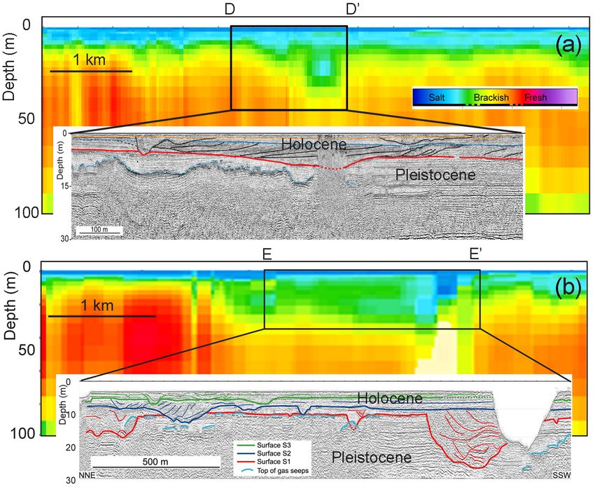
L. Tosi et al.: Continental and marine surficial water                                                                                 389

Figure 2. Multi-layer vertical resistivity sections obtained from the
AEM survey (see section position in Fig. 1). The freshwaters are
highlighted by a black oblique hatching.

quality rapidly decays with the increase of the lagoon and
sea bathymetry, it is reasonably to suppose that continental
groundwaters flow up to a few km offshore. In the lagoon                Figure 3. Conceptualization of the freshwater-saltwater relation-
sector, groundwater is salty again below 70–80 m depth,                 ship at different depths, obtained by integrating the results of
probably because of its fossil marine origin, while in the              the AEM survey with previous available information: (a) 0–1 m,
                                                                        (b) 12–15 m, (c) 55–63 m, (d) 91–108 m. Fresh-, brackish- and salt-
mainland freshwater aquifers occur (Fig. 2). Notice that in
                                                                        waters are represented by red, green/yellow and blue colors, respec-
the lagoon sector, the AEM survey did not produce reliable              tively. White and black arrows delineate the advancement of the
data for a rigorous interpretation deeper than 100 m.                   saltwater intrusion and freshwater flow, respectively.

3.2   Model of the fresh water–saltwater interaction

The pseudo-3-D electrical resistivity dataset provided by               4   Discussion
AEM is used to map the presence of saltwater and freshwa-
ter at different depths. Electrical resistivity data were inter-        AEM provides a continuous image of the freshwater and
polated on a 1 km regular grid by the Kriging method and the            saltwater distribution in the transitional coastal aquifers of
results classified as freshwater and saltwater for values < 5           the southern Venice lagoon and northern Po River Delta.
and > 10  m, respectively. The values between these limits             Moreover, the integrated use of additional data, such as very
are used to map the brackish transitional zone.                         high resolution seismic (VHRS) profiles together with geo-
   Figure 3 shows the conceptualization of the freshwater-              morphological and sedimentological analyses, has allowed a
saltwater relationships at four different depths. The first layer       clearer understanding of the mechanisms driving surface wa-
(0–1 m depth interval, Fig. 3a) highlights the marine-lagoon            ter and groundwater exchanges.
and the land areas by blue and red color, respectively, with               The analysis highlights that the high conductivity shallow
the exception of some low-lying sectors in the southernmost             deposits correspond to the Holocene units (Fig. 4), which
zone where saltwater contaminates also agricultural soils.              are characterized by marine and lagoon-back barrier sedi-
Freshwater below the Venice lagoon is unevenly detected be-             ments, more permeable and less compacted than the deeper
tween 10 and 20 m depth (Fig. 3b) and more generally oc-                Pleistocene alluvial ones (e.g., Tosi et al., 2007 and refer-
curred in the 60–70 m depth range (Fig. 3c). Southward of               ences therein). The setting of the saltwater-freshwater tran-
the lagoon margin, saltwater intrudes from the lagoon and the           sitional zone is very complex and likely related to the loca-
sea and extends to the whole mainland, including the north-             tion of an aquitard partially confining the Holocene deposits,
ern Po River delta. Saltwater is encountered at depth larger            well known by Venetians as caranto. It consists in an over-
than about 90–100 m in the aquifers below the lagoon while              consolidated stiff layer forming the uppermost part of the
freshwaters are detected in the mainland sectors (Fig. 3d).             Pleistocene units (e.g., Bonardi et al., 2006; Tosi et al., 2007).

proc-iahs.net/379/387/2018/                                                                          Proc. IAHS, 379, 387–392, 2018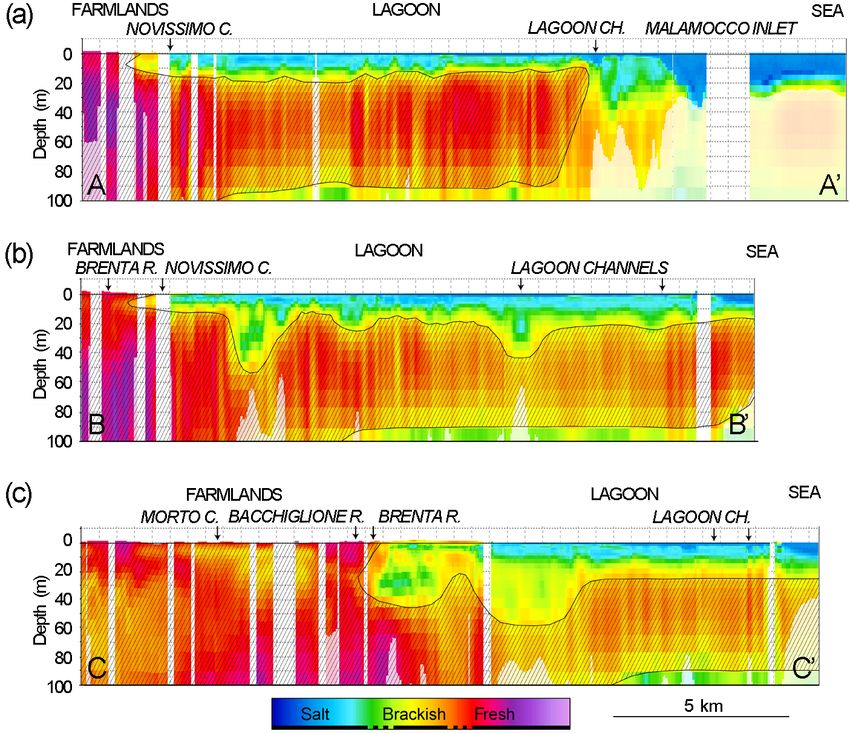
390                                                                           L. Tosi et al.: Continental and marine surficial water

                                                                       5   Conclusions

                                                                       We have explored the capability of the AEM technique
                                                                       to investigate the continental and marine surficial water–
                                                                       groundwater interactions in a large portion of the coastland
                                                                       encompassing the southern Venice lagoon and the northern
                                                                       Po river delta. The AEM has allowed to overcome the lo-
                                                                       gistical problems typical of the ground-based measurements
                                                                       in coastal transitional environments crossed by rivers, canals
                                                                       and lagoons. AEM has provided a continuous and almost si-
                                                                       multaneous image of the relative position of saltwater and
                                                                       freshwater, suggesting the main mechanisms governing the
                                                                       exchange between surface water and groundwater. Signifi-
                                                                       cant information on these water interactions has been ob-
                                                                       tained at “regional” scale and with a good detail even in some
                                                                       local situations. The main results are summarized as follows.
                                                                          The infiltration of the lagoon and marine waters is less
Figure 4. Vertical resistivity and seismic sections along the align-   deep than it was supposed in the past.
ments D–D0 (a) and E–E0 (b) sketched in Fig. 1. The red line repre-       Fresh and brackish waters have been identified underneath
sents the Pleistocene–Holocene boundary.                               the lagoon basin from only 15–20 m depth, locally even
                                                                       less, and down to about 70–80 m. Below this depth, a saline
                                                                       aquifer probably of fossil origin is detected in the lagoon sec-
   Localized seepages of saltwater from the lagoon bottom              tor.
at larger depths involving the Pleistocene deposits (Fig. 4)              Fresh and brackish aquifers extend beyond the littoral to
can be observed. Their location corresponds with the lagoon            the nearshore and could give rise to local SGD.
channels where the caranto clay layer misses. Other deeper                The saltwater–fresh water transition zone is very
saltwater infiltrations are related to the presence of buried          irregularly-shaped and mainly depends on the morphologic
paleo-channels, which are generally filled with coarse and             setting and the subsoil architecture.
more permeable sediments than those forming the lagoon                    The saline infiltration from the lagoon bottom is controlled
bottom.                                                                by an over-consolidated clay layer and the presence of buried
   Similarly to the lagoon basin, also in the inland the mor-          geomorphological structures, generally sandy bodies (e.g.,
phology and subsoil architecture play an important role in de-         paleo-channels).
termining the relationship between fresh and salt groundwa-               In the mainland, sandy buried paleo-channel systems can
ter (Fig. 3). In the littoral sector, generally characterized by a     increase the saltwater flow from the lagoon into the low-lying
ground elevation a few meter above the mean sea level, rain-           sectors, while sandy paleo-ridge systems are capable to con-
falls favour the formation of rather continuous fresh ground-          tain fresh groundwater.
water lens, about 10 m thick and even more, in the sandy sub-             Saltwater intrusion is worryingly spreading in the whole
soil. Conversely, in the areas lying below the mean sea level          southern sector, mostly in the low-lying farmland, with the
(up to 4 m) managed by hydraulic reclamation, saltwater con-           exception of the zones around the Brenta river where the con-
tamination affects the farmland from the subsoil down to 50–           tamination is restricted.
60 m depth (Fig. 3). Moreover, the presence of sandy buried               Concluding, further quantitative investigations targeted
paleo-channel systems crossing the farmland, with a main               at quantifying the continental and marine surface water–
direction from inland to the lagoon boundary, acts as pref-            groundwater exchanges, as well as at developing numerical
erential pathways for groundwater flow and solute transport.           models for the prediction of the future behaviour in light
These structures generally increase the saltwater flow from            of the expected climate changes, will benefit from the out-
the lagoon into the low-lying sectors, even though they allow          comes of this study. Moreover, this work can help detecting
a short-term storage of rainwater in the very shallow sub-             the zones at higher risk, where local more detailed investi-
soil. Conversely, sandy paleo-ridge systems are capable to             gations must be performed to improve the knowledge of the
contain groundwater with lower salinity than that occurring            vulnerability of the farmland to saltwater contamination.
in the paleo-channels, at least in the shallow part. For both
paleo-channels and paleo-coastal ridges, the water quality is
significantly improved by local rainfalls that rapidly supply
freshwater.

Proc. IAHS, 379, 387–392, 2018                                                                         proc-iahs.net/379/387/2018/
L. Tosi et al.: Continental and marine surficial water 391
Data availability. The AEM data presented here are part of an Venezia, Ist. Bosco e Grandi Parchi, Museo di Storia Naturale
ongoing project and, therefore, will be available on completion di Venezia, Istituzione Centro Previsioni e Segnalazioni Maree,
of the research. They will be available on the website of the http://cigno.atlantedellalaguna.it, Atlante della Laguna, last ac-
Institute of Marine Sciences – National Research Council, Italy cess: 30 December 2017.
(http://www.ismar.cnr.it/index_html-1?set_language=en&cl=en). Da Lio, C., Tosi, L., Zambon, G., Vianello, A., Baldin, G., Loren-
Geological and hydrogeological data are available through zetti, G., Manfe, G., and Teatini, P.: Long-term groundwater dy-
the following websites: Città Metropolitana Venezia namics in the coastal confined aquifers of Venice (Italy), Estuar.
(2017) http://webgis.cittametropolitana.ve.it/geologia, Coast. Shelf Sci., 135, 248–259, 2013.
http://difesasuolo.provincia.venezia.it/DifesaSuolo/Index? Da Lio, C., Carol, E., Kruse, E., Teatini, P., and Tosi, L.: Saltwater
pagina=1&id=banca_dati_idrogeologica; Istituto Superi- contamination in the managed low-lying farmland of the Venice
ore per la Protezione e la Ricerca Ambientale (2017) coast, Italy: An assessment of vulnerability, Sci. Total Environ.,
http://www.isprambiente.gov.it/Media/carg/veneto.html; CNR- 533, 356–369, 2015.
ISMAR, CORILA, Regione del Veneto, Magistrato alle Acque de Franco, R., Biella, G., Tosi, L., Teatini, P., Lozej, A., Chiozzotto,
di Venezia, ARPA Veneto, Consiglio di Bacino Laguna di B., Giada, M., Rizzetto, F., Claude, C., Mayer, A., Bassan, V., and
Venezia, Geoportale Nazionale, IVSLA, Ist. Parco Laguna di Gasparetto-Stori, G.: Monitoring the saltwater intrusion by Time
Venezia, Ist. Bosco e Grandi Parchi, Museo di Storia Naturale di Lapse Electrical Resistivity Tomography: The Chioggia test site
Venezia, Istituzione Centro Previsioni e Segnalazioni Maree (2017) (Venice Lagoon, Italy), J. Appl. Geophys., 69, 117–130, 2009.
http://cigno.atlantedellalaguna.it; Regione del Veneto (2017) http: Istituto Superiore per la Protezione e la Ricerca Ambi-
//gisgeologia.regione.veneto.it/website/venezia-10k/viewer.htm. entale: http://www.isprambiente.gov.it/Media/carg/veneto.html,
Progetto CARG, last access: 30 December 2017.
Mayer, A., Gattacceca, J., Claude, C., Radakovitch, O., Giada,
Competing interests. The authors declare that they have no con- M., Cucco, A., Tosi, L., and Rizzetto, F.: Radon activity in the
flict of interest. southern Lagoon of Venice and the Adriatic Sea, in: Scientific
Research and Safeguarding of Venice 2005, edited by: Cam-
postrini, P., CORILA, Research Program 2004–2006, 4, 217–
Special issue statement. This article is part of the special issue 226, Venezia, 2006.
“Innovative water resources management – understanding and bal- Rapaglia, J.: Submarine groundwater discharge into the Venice la-
ancing interactions between humankind and nature”. It is a result of goon, Italy, Estuaries, 28, 705–713, 2005.
the 8th International Water Resources Management Conference of Regione del Veneto: http://gisgeologia.regione.veneto.it/website/
ICWRS, Beijing, China, 13–15 June 2018. venezia-10k/viewer.htm, Progetto CARG, last access: 30 De-
cember 2017.
Rizzetto, F., Tosi, L., Carbognin, L., Bonardi, M., and Teatini, P.:
Geomorphic setting and related hydrogeological implications of
Acknowledgements. The Flagship Project RITMARE – The
the coastal plain south of the Venice Lagoon, Italy, IAHS-AISH
Italian Research for the Sea – coordinated by the Italian National
Publ., 278, 463–470, 2003.
Research Council and funded by the Italian Ministry of Education,
Teatini, P., Tosi, L., Viezzoli, A., Baradello, L., Zecchin, M., and
University and Research within the National Research Program
Silvestri, S.: Understanding the hydrogeology of the Venice la-
2011–2013.
goon subsurface with airborne electromagnetics, J. Hydrol., 411,
342–354, 2011.
Edited by: Depeng Zuo
Tosi, L., Rizzetto, F., Bonardi, M., Donnici, S., Serandrei Bar-
Reviewed by: two anonymous referees
bero, R., and Toffoletto, F.: Note illustrative della Carta Geo-
logica d’Italia alla scala 1: 50.000, Foglio 148–149 Chioggia-
Malamocco, APAT, Dipartimento Difesa del Suolo, Servizio Ge-
References ologico d’Italia, SystemCart, Roma, 164 pp., 2 Maps, 2007.
Tosi, L., Rizzetto, F., Zecchin, M., Brancolini, G., and Baradello, L.:
Bonardi, M., Tosi, L., Rizzetto, F., Brancolini, G., and Baradello, L.: Morphostratigraphic framework of the Venice lagoon (Italy) by
Effects of climate changes on the late Pleistocene and Holocene very shallow water VHRS surveys: evidence of radical changes
sediments of the Venice Lagoon, Italy, J. Coastal. Res., 39, 279– triggered by human-induced river diversions, Geophys. Res.
284, 2006. Lett., 36, https://doi.org/10.1029/2008GL037136, 2009.
Carbognin, L. and Tosi, L.: Il Progetto ISES per l’analisi dei pro- Tosi, L., Baradello, L., Teatini, P., Zecchin, M., Bonardi, M., Shi,
cessi di intrusione salina e subsidenza nei territori meridionali P., Tang, C., Li, F., Brancolini, G., Chen, Q., Chiozzotto, B.,
delle Province di Padova e Venezia, Grafiche Erredici, Padova Frankenfield, J., Giada, M., Liu, D., Nieto, D., Rizzetto, F.,
(Italy), 95 pp., 2003. Sheng, Y., Xiao, Y., and Zhou, D.: Combined continuous elec-
Città Metropolitana Venezia: http://webgis.cittametropolitana.ve. trical tomography and very high resolution seismic surveys to
it/geologia, http://difesasuolo.provincia.venezia.it/DifesaSuolo/ assess continental and marine groundwater mixing, Boll. Geofis.
Index?pagina=1&id=banca_dati_idrogeologica, Banca dati geo- Teor. Appl., 52, 585–594, 2011.
logica e idrogeologica, last access: 30 December 2017. Viezzoli, A., Tosi, L., Teatini, P., and Silvestri, S.: Sur-
CNR-ISMAR, CORILA, Regione del Veneto, Magistrato alle face water-groundwater exchange in transitional coastal
Acque di Venezia, ARPA Veneto, Consiglio di Bacino Laguna environments by airborne electromagnetics: the Venice
di Venezia, Geoportale Nazionale, IVSLA, Ist. Parco Laguna di
proc-iahs.net/379/387/2018/ Proc. IAHS, 379, 387–392, 2018392 L. Tosi et al.: Continental and marine surficial water
Lagoon example, Geophys. Res. Lett., 37, L01402, Zecchin, M., Caffau, M., and Tosi, L.: Relationship between peat
https://doi.org/10.1029/2009GL041572, 2010. bed formation and climate changes during the last glacial in the
Venice area, Sediment. Geol., 238, 172–180, 2011.
Proc. IAHS, 379, 387–392, 2018 proc-iahs.net/379/387/2018/You can also read