Creating City Models in ArchiCAD Software Environment
←
→
Page content transcription
If your browser does not render page correctly, please read the page content below

The International Journal of Engineering and Science (IJES)
|| Volume || 10 || Issue || 1 || Series I || Pages || PP 11-17 || 2021 ||
ISSN (e): 2319-1813 ISSN (p): 20-24-1805

       Creating City Models in ArchiCAD Software Environment
                                           Péter Fejes1, András Horkai1
                    1
                        Óbuda University, Ybl Miklos Faculty of Architecture and Civil Engineering,
                                            Institute of Architecture, Hungary
                                         Corresponding Author: András Horkai

-----------------------------------------------------------ABSTRACT-------------------------------------------------------------
In the 1960s, the 3D-based design from the aviation and automotive industries has now fundamentally changed
the construction industry too. Model-based processes open up new opportunities in both design and decision
support: engineers have been able to do various spatial tests and simulations. However, our buildings (whether
they are residential or public buildings) are typically cannot be interpreted without the conditions – the urban
fabric – next to them, the modelling of which often places a considerable burden on architects.
Given that GRAPHISOFT ArchiCAD is the most frequently used design software among architects in Hungary,
present research aimes to explore and evaluate 3D modeling methods that allow the fast creation of city models
in ArchiCAD software environment. The site was based on the traditional extrusion from (exploded) site plan,
the examination of items that can be downloaded from the CADMAPPER website, and an important part of the
analysis of Rhino with Live Connection to ArchiCAD and the associated Grasshopper (Meerkat and Elk
plugins).
As a result of the studies, it can be concluded that, on the basis of the time available and the content of the data,
there are several possibilities for creating a fast city model in ArchiCAD. If data is available in geospatial
format, Grasshopper + Meerkat was the most appropriate solution based on our research. If you don't need
such an accurate model, you can use it immediately by downloading it from CADMAPPER website. Tradition
footprint-based extrusion was the best solution for complex building geometry.
KEYWORDS;- ArchiCAD, BIM, city model, footprint, GIS, Grasshopper
---------------------------------------------------------------------------------------------------------------------------------------
Date of Submission: 28-12-2020                                                                  Date of Acceptance: 09-01-2021
---------------------------------------------------------------------------------------------------------------------------------------

                                            I.    INTRODUCTION
          The digitalization in the world offers more and more opportunities at a fast pace, which the developing
construction industry should not miss. With the advent of computer 3D design, the requirements that form the
basis of BIM (Building Information Modeling) appeared as early as the 1970s. In virtual space, a set of
buildings composed of pre-defined and 3D model elements embodying real buildings, which virtual model can
later be further shaped interactively and for many purposes, e.g. can also be used to run simulations.
          District-level simulations are especially important in the case of urban decision support and urban
planning, as this allows us to see in advance what is happening, e.g. in case of demolition / reconstruction of a
certain building / block of buildings; what are the consequences of the modification of the settlement regulation
plans (e.g.: the effect of several tall buildings, denser construction on the ventilation and sunbathing of the
settlement part). Or even an ex-post audit is appropriate: what impact has a particular investment had on the
built environment.
          Possibilities of using city models without the need for completeness: solar radiation estimation, energy
demand estimation, floor area determination, flight simulations, visibility analysis, shadow studies, noise
propagation estimation, building registration, urban planning, green infrastructure planning, evacuation
planning, radio wave propagation studies, flood studies [1]. The figures below show examples.

DOI:10.9790/1813-1001011117                                      www.theijes.com                                             Page 11
Creating City Models in ArchiCAD Software Environment

          In reviewing potential uses, there are studies that do not necessarily require a BIM model, such as
certain meteorological / climatic studies (since this property depends almost exclusively on the geolocation of
the building, not on its shape or structural properties). Such analyzes can be performed with a relatively simple
set of tools — using building models and weather files (which include temperature, wind, and humidity
conditions, among others).
          In the Hungarian context, the models for the analyzes are most often made by the architects and the
simulations are performed either by them or by specialists. Of the BIM-based design software available on the
Hungarian market, ArchiCAD is the most commonly used software among architects [5]. The present study is
the first phase of a longer study to investigate modeling opportunities that create opportunities for modeling and
importing into ArchiCAD software environment.

                                           II.    CASE STUDY AREAS
           To present the modeling methods, two markedly different case study areas in terms of building
character were selected: a densely built, downtown fabric; and a housing estate, which was built with
prefabricated techology. Both sample areas are located in the Hungarian capital, Budapest. The downtown fabric
is some block of the 7th district (Belső-Erzsébetváros, Klauzál square and its surroundings), and the housing
estate is in the 14th district (Füredi street housing estate).
           The building stock in Belső-Erzsébetváros consists of multi-apartment condominiums in the city
center, built in a closed row, decorated with historical style elements. Buildings are typically connected to their
neighbours by a firewall on 2-3 sides. They usually have an inner courtyard surrounded by wings on 3-4 sides.
The depth of the street facade is greater, and the apartments in it are more spacious than in the courtyard wings.
The street wing is covered by a gable roof and the courtyard by a half gable roof [6].

DOI:10.9790/1813-1001011117                            www.theijes.com                                    Page 12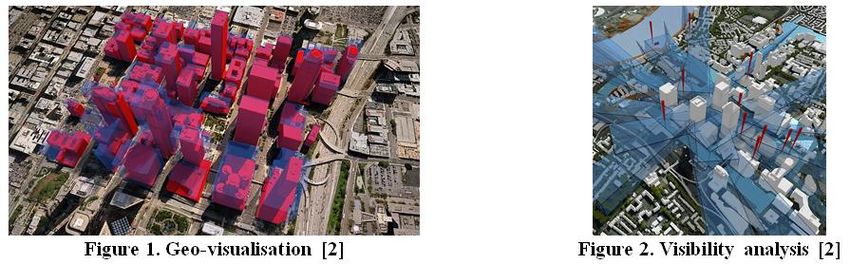
Creating City Models in ArchiCAD Software Environment

                               Figure 6. City fabric of the downtown area [7]

          The housing estate on Füredi Street - also known as Zuglói housing estate - was built in three phases
between 1967-78 (Phase I: Fogarasi Road - Vezér Road - Füredi Road - Rákos Stream; Phase II: Kerepesi Road
- Szentmihályi Road - Füredi Road - Örs vezér Phase III: Örs vezér tér - Egressy tér – Road of Nagy Lajos
király). The buildings are made with prefabricated concrete panel technology, mostly with eleven storeys [8].

                           Figure 7. City fabric of the Füredi housing estate [7]

                             III.    ANALYSED MODELLING METHODS
         Several modelling procedures with the usage of ArchiCAD are presented below. The methods were all
tested during the research. These procedures can be used to produce a LOD1-level model of the city/district.
         The models were created in part with an add-on called Rhino Grasshopper, which can run algorithms
and build models from a geospatial database. Intermediate add-ons were needed in Grasshopper, these were the
Meerkat and Elk plugins. One way to import GIS data into BIM is to set up Grasshopper, which can be
connected to Rhino, and ArchiCAD, which connects to it with the Live Connection extension.

Grasshopper - Meerkat
         In Grasshopper, an extension called Meerkat can be used to extract data from which to create
simplified city models. (Meerkat is a toolset that Grasshopper uses to generate geometry from GIS files.)
Meerkat retrieves the required data from the Google Maps database using *.shp (shape) files. After creating the
algorithm, the add-on saves the data to a file with a *.mkgis (Meerkat GIS) extension, from which it builds a
model that can be imported into ArchiCAD with a continuous data connection [9, 10].
         The *.shp files required for Meerkat may be available, for example, by exporting from the State Plot
Cadastre (with an official data request) or by converting *.osm format files that can be downloaded from the
free OpenStreetMap interface to *.shp. It is important to note that in Hungary, neither the State Plot Cadastre
nor the OSM database contains the height data of the buildings, so the database must be filled in manually with
DOI:10.9790/1813-1001011117                          www.theijes.com                                   Page 13
Creating City Models in ArchiCAD Software Environment

them. In the present research, after the on-site measurements, these data was loaded into the *.shp files in the
free and open source GIS system, QGIS [11].
         The shapefile format is a geospatial vector data format for geographic information system (GIS)
software. The shapefile format can spatially describe vector features: points, lines, and polygons, representing,
for example, water wells, rivers, and lakes. Each item usually has attributes that describe it, such as name or
temperature [12].

                                Figure 8. Algorithm created in Grasshopper

Grasshopper - Elk
         Grasshopper's "Elk" extension provides access to *.osm files on the OpenStreetMap (OSM) Website
and USGS (United States Geological Survey) *.dem files, as well as topographic data in GeoTIFF format. Using
the downloaded files, a model can be generated after the algorithm has been created, which can be imported into
ArchiCAD with a continuous data connection [9].
         Elk is actually a toolset that can be used to create maps and topographic interfaces using open source
data from OpenStreetMap.org and the USGS.

CADMAPPER
         After registering from https://cadmapper.com, an area of up to 1 km2 of the area you are looking for is
available free of charge. This area can be downloaded in file formats compatible with various programs (such as
AutoCAD, SketchUp, Rhinoceros, Illustrator, etc.). The database is not complete and does not contain elevation
data for all buildings. During the download, you can specify in the area settings whether the program will apply
a “false” height to the height of the missing buildings. The database is also suitable for downloading
topographic models. Area models can be downloaded from the website in * .dxf ArchiCAD compatible file
format, among others [13].

DOI:10.9790/1813-1001011117                           www.theijes.com                                   Page 14
Creating City Models in ArchiCAD Software Environment

                                   Figure 9. CADMAPPER interface

      The downloaded file can be embedded in ArchiCAD without further conversion. In ArchiCAD, the
DXF model appears as an Object element, which can be converted to a Morph element for further ease of use.

                     Figure 10. Model extracted from CADMAPPER in ArchiCAD

Traditional method - extrusion from site plan
        Existing DWG layouts can also be the basic of modeling – and in many cases they are used in
Hungarian practice. Elevation data for buildings can be derived from field measurements, Google Earth
measurements, or official databases.

DOI:10.9790/1813-1001011117                        www.theijes.com                                Page 15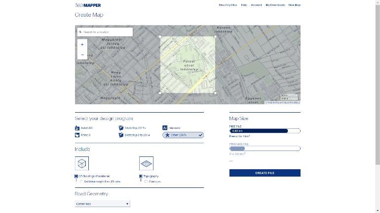
Creating City Models in ArchiCAD Software Environment

                                  Figure 11. Extrusion from site plan in ArchiCAD

        During this method, the DWG site plan can be imported into ArchiCAD and then used a spatial
modeling tool (e.g. slab or morph) to create a building model of the desired height.

                                            IV.     CONCLUSIONS
         In the present research, partially or fully automatic urban modeling methods have been tested, which
are suitable for creating and managing models in the ArchiCAD software environment, which is the most widely
used on the Hungarian market.
         As a result of the investigations, it can be seen that several possibilities are available for the preparation
of the model of the settlement parts. Which option is selected depends mostly on the amount of basic data and
the time available. If the data is available in a GIS format, Grasshopper + Meerkat was the most expedient and
simplest solution based on our research. If you don't need an accurate model that faithfully returns the real
geometry of the buildings, downloading it from the online CADMAPPER interface, which can be used
immediately, but in some places more inaccurate, has proven to be the fastest and easiest method. The
conventional footprint-based extrusion was the best solution for complex building geometries and different
height conditions (e.g. tower-like building parts).

                                        ACKNOWLEDGEMENTS
         This research is supported by the ÚNKP-19-1-I-SZIE-4 New National Excellence Program of the
Ministry for Innovation and Technology.

                                                        REFERENCE
[1].   F. Biljecki, H. Ledoux, and J. Stoter, An improved LOD specification for 3D building models, Computers, Environment and Urban
       Systems, vol. 59, 2016/09/01/ 2016, 25-37.
[2].   CiberCity3D. (2020). Uses. URL: https://www.cybercity3d.com/uses
[3].   DataKustik. City Noise Mapping. URL: https://www.datakustik.com/noise-outdoors/city-noise-mapping/
[4].   Microwaves&RF. (2017). Mapping the Way for IoT Radio Waves. URL: https://www.mwrf.com/software/mapping-way-iot-radio-
       waves
[5].   G. H. P. Intézet, A Graphisoft ArchiCad a legnépszerűbb BIM-alapú szoftver az építészek és kivitelezők körében, 2017).
[6].   V. Sugár, A. Horkai, Z. Pap, and A. Talamon, "Századfordulós bérházak energetikai lehetőségei," in Környezet és energia:
       Hatékony termelés, tudatos felhasználás, I. Lázár, Ed., ed Debrecen: MTA DAB Földtudományi Szakbizottság, 2018, pp. 93-98.
[7].   Apple Maps. URL: https://www.apple.com/ios/maps/
[8].   L. Berza, Budapest Lexikon (Budapest, Akadémiai Kiadó, 1993).
[9].   E. Fontan. (2019). GIS to BIM – ARCHICAD & Grasshopper. URL: http://www.weareenzyme.com/gis-to-bim-archicad-
       grasshopper/?fbclid=IwAR1jyEZiLvjhIDXS3zuTuOBLVAib_c4qGDMuUbl4V-WkbcLJPIXRnSgsMvA

DOI:10.9790/1813-1001011117                                    www.theijes.com                                            Page 16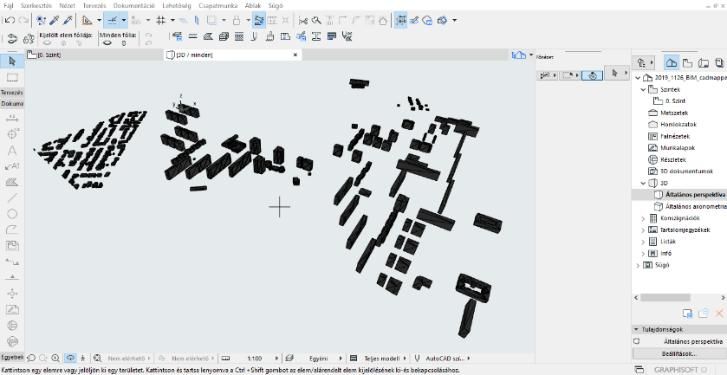
Creating City Models in ArchiCAD Software Environment
[10].   C.             McAdams.                (2016).              Meerkat          for             Grasshopper.      URL:
        https://www.youtube.com/watch?v=B92r3Nc2StU&t=185s&ab_channel=ChristopherMcAdams
[11].   QGIS. A Free and Open Source Geographic Information System. URL: https://qgis.org/en/site/
[12].   Wikipedia. (2015). Shapefile. URL: https://en.wikipedia.org/wiki/Shapefile
[13].   CADMAPPER. Instant CAD files for any location on earth. URL: https://cadmapper.com/

  András Horkai, et. al. "Creating City Models in ArchiCAD Software Environment." The International
  Journal of Engineering and Science (IJES), 10(01), (2021): pp. 11-17.

DOI:10.9790/1813-1001011117                                     www.theijes.com                                     Page 17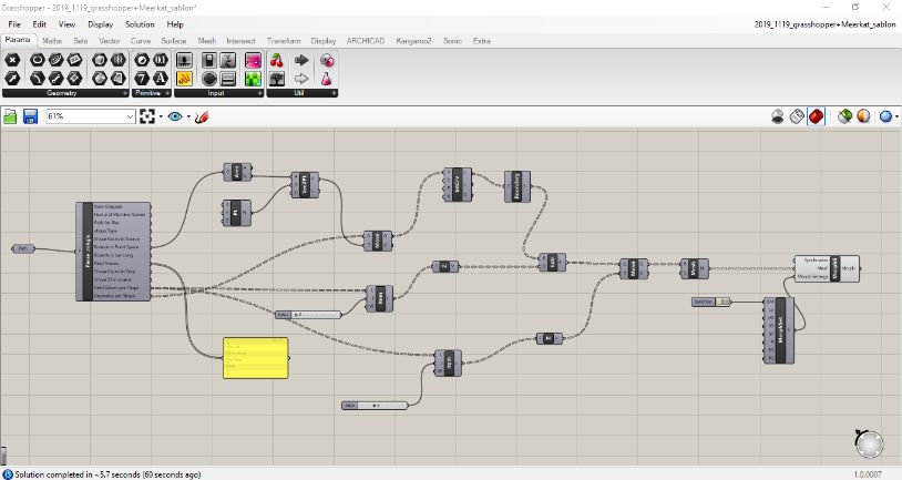
You can also read