Deliverable D.T1.1.1 short version - Ex-ante analysis of current journey planners - Alpine Space
←
→
Page content transcription
If your browser does not render page correctly, please read the page content below

Deliverable D.T1.1.1 short
version
Ex-ante analysis of current journey planners

Version: 4.0

Dissemination level: No restriction (public version)

WP: WPT1 – A.T1.1 Ex-ante Analysis and current uptake of Journey Planners

Author: LINKS, UM-FGPA

                                                         http://www.alpine-space.eu/linkingalps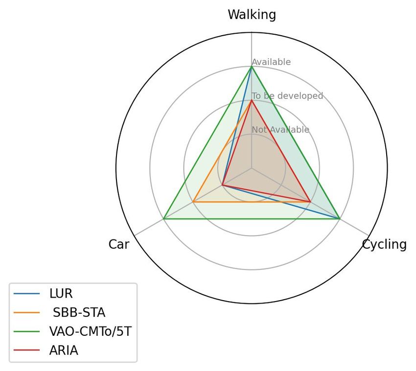
Document Information
Authors
Name PartnerNo Organisation
Alexander Fazari LINKS
Tiziana Delmastro LINKS
Stefano Pensa LINKS
Maurizio Arnone LINKS
Andrej Tibaut UM-FGPA
Peer-Reviewer
Name PartnerNo Organisation
Nenad Čuš Babič UM-FGPA
Sara Guerra de Oliveira UM-FGPA
Document History
Date Version Summary of changes Dissemination
19/05/2020 1 D.T1.1.1 Project partners
03/06/2020 2 D.T1.1.1 Peer review LINKS, ATE, UM-FGPA
29/06/2020 3 D.T1.1.1 Final version Project partners
10/08/2020 4 D.T1.1.1 Short version
Public
draft
07/09/2020 5 D.T1.1.1 Short version
Public
partner revision
LinkingAlps Deliverable DT1.1.1 Ex-ante Analysis 2Preface
Acronym: LinkingAlps
Title: Innovative tools and strategies for linking mobility information services in a
decarbonised Alpine Space
Project number: 740
Start Date: 01-10-2019
End Date: 30-06-2022
Call number: 4th call
Priority: Priority 2 - Low Carbon Alpine Space
Specific objective: SO2.2 - Increase options for low carbon mobility and transport
LinkingAlps Deliverable DT1.1.1 Ex-ante Analysis 31
Glossary
Terms Definition
The active system integrates the routing information from several local
journey planners to a combined seamless route. It is composed of a passive
system and a distributing system. It communicates through an OJP
Active system interface. It's a journey planning engine with OJP capabilities. Via the
distributing system it is able to detect journeys through adjacent or remote
regions and able to create OJP Trip Compositions.
Alias OJP Router.
System that distributes journey planning enquiries to other systems. It
sends the request for journey-parts through areas to the corresponding
Distributing system passive servers, receives the responses and is able to create OJP Trip
Compositions. It has the knowledge about gazetteers and is able to collect
information about exchange points for the whole system.
End user User of an end-user service; travellers.
Alias home-system. It is the participating system called by the end user
Enquirer system application. It is the system that takes care of the end user travel
information request and provides an answer.
Exchange point It’s a stop or a station where the local connection of one system is linked to
the long distance connection of another system. This includes regional
stops which match with stops for long distance or regional stops from
adjacent regions. Exchange points are mainly but not exclusively located at
borders and in bigger cities.
It’s a directory of common objects across the local journey planner systems
Gazetteer and its system borders. It enables the active system to find the passive
system for all geolocations (stops, stations, points of interest, address etc.).
The Graphical User Interface is a form of user interface that allows users to
GUI
interact with electronic devices through graphical icons.
Identification of Fixed Objects in Public Transport, a logical data model for
IFOPT the fixed objects relevant for public transport, in particular for stops and
points of interest.
1
Most definitions are from the LinkingAlps official Glossary
LinkingAlps Deliverable DT1.1.1 Ex-ante Analysis 4Journey Planner, a system that is calculating the journey for a given
JP
request. It is able to accept requests directly from end-user services.
A system with a routing engine and access to multimodal data with a
Local Journey Planner
particular local, regional or national coverage; “local” underlines its focus
(LJP)
on a specific coverage that is limited. LJPs have no OJP routing capabilities.
The territory for which the journey planner can plan trips itself without
Local region
information from other systems.
NeTEx Network Timetable Exchange (CEN/TS 16614 ff).
OJP is an Open API for distributed journey planning that allows a system to
engineer just one interface to exchange accurate and timely information
OJP
about public transport (PT) services and to implement systems able to
provide multi-modal information for longer-distance journeys.
Travel information service providers that are implementing an OJP service
OJP implementers
exchange (in most cases on the back-end system of an end user service).
Application Programming Interface (API) based on CEN/TS 2017: OpenAPI
OJP Interface for distributed journey planning and specified in D.T1.5.1 Specification of
the API interface (including a LinkingAlps OJP Profile).
An end user service provider that is using OJP services from local JPs to
OJP user
provide an end-user service.
OSM OpenStreetMap is an open source street level map of the world.
A system (service) that is part of a decentralised network of JPs established
Participating system
through OJP.
Alias OJP responder, responding system.
A Local Journey Planner (LJP) with a OJP interface (API) being able to
Passive system respond to requests from distributing systems. It is an information source
within the system without distributed journey planning capabilities. It
communicates through an OJP interface as a responding system.
The real time of a particular means of transport at a particular stop; only
Real time data
sent after the arrival/departure of the vehicle to/from that stop.
The generalized term for a system that responds to questions from the
Responding system
distributing system.
Technical, self-sufficient unit that bundles related functionalities into a
Service
complex of topics and makes them available via a clearly defined interface.
SIRI Service Interface for Real time Information (CEN/TS 15531).
LinkingAlps Deliverable DT1.1.1 Ex-ante Analysis 5OJP implementers
Territory Active or
Organization (Acronym) Journey Planning System
(Country) passive system
The Verkehrsauskunft
Austria routenplaner.verkehrsauskunft.at Active
Österreich (VAO)
Provincia
autonoma di Strutture Trasporto Alto Südtirolmobil
Active
Bolzano Adige Spa (STA) http://www.suedtirolmobil.info/
(ITA)
Schweizerische
Switzerland https://www.sbb.ch/de/ Active
Bundesbahnen (SBB)
Azienda Regionale Muoversi in Lombardia
Regione
Innovazione e Acquisti http://www.muoversi.regione.lombardia.it Passive
Lombardia (ITA)
S.p.a. (ARIA) /
Regione Piemonte Città Metropolitana di Torino Muoversi in Piemonte
Passive
(ITA) (CMTo) via the in-house 5T https://www.muoversinpiemonte.it/
Regionalna razvojna agencija
AtoB Ljubljana
Slovenia Ljubljanske urbane regije Passive
http://www.atob.si/
(RRA LUR)
LinkingAlps Deliverable DT1.1.1 Ex-ante Analysis 6Table of Contents
1 Introduction 9
2 Ex-ante analysis methodology 9
3 Summary of JPs’ main features, commonalities and differences 14
3.1 Services and engines 14
3.1.1 Transport Modes 14
3.1.2 Request Options 15
3.1.3 Geographical details 17
3.1.4 Languages 18
3.1.5 System Architecture 18
3.1.6 Data governance 18
3.2 Open API Requests 18
LinkingAlps Deliverable DT1.1.1 Ex-ante Analysis 7Table of Annexes Document Information 2 Preface 3 Glossary 4 OJP implementers 6 LinkingAlps Deliverable DT1.1.1 Ex-ante Analysis 8
1 Introduction
The objective of WPT1 - A.T1.1 “Ex-ante Analysis and current uptake of Journey Planners (JPs)" can
be summarized in two main activities.
Task 1 deals with the ex-ante analysis of the current features of local JPs and the uptake of
innovations (such as the Open Journey Planning API - OJP). The action intends to summarize the
main technical information on the participating systems involved in LinkingAlps as the basis for the
interoperability of the OJP services and the development of the distributed system.
Task 2 deals with the current uptake of travel information services and aims to collect information
about the current use of the participating systems (e.g. type of requested information , frequency of
accesses, type of users and end users, etc.) and about potential OJP users’ needs and requirements
for multimodal travel information services.
Deliverable D.T1.1.1 shows the results obtained in Task 1 through the JPs ex-ante analysis.
2 Ex-ante analysis methodology
The ex-ante analysis is based on the data collected through a questionnaire that was specifically
designed and distributed to the six OJP implementers (SBB - Switzerland, VAO - Austria, STA -
Bolzano Province, IT, LUR - Slovenia, ARIA - Lombardia Region, IT, CMTo/5T - Piemonte Region, IT)
involved in LinkingAlps project and currently developing and managing the local JPs that will be
linked together through the implementation of a distributed system based on OJP.
In particular, the analysis was carried out through specific steps requiring:
1. the identification of the relevant aspects and features needed for the interoperability of OJP
services and for information exchange;
2. the design of a questionnaire to collect information for all the local JPs about the aspects
identified in the previous step and to provide a conceptual knowledge about what
information existing JPs can offer/process and what information can be queried with OJP
schemas;
3. the collection of the requested information;
4. the assessment and analysis of the provided responses and the identification of
commonalities and differences between the participating systems and of the current gaps
and interoperability problems.
The main features to be investigated were selected by the LINKS Foundation and University of
Maribor mainly based on interoperability aspects with regard to the syntax and the content of the
LinkingAlps Deliverable DT1.1.1 Ex-ante Analysis 9services (schema, modelling of IDs, terminology, etc.). Furthermore, relevant features for providing
a complete overview on the available modes, request options, geographical coverage and
governance of data of the local JPs were considered.
Most features were defined and described with reference to the OJP Schema as defined in the Open
API for Distributed Journey Planning (CEN/TS 17118:2017). Furthermore, European Standards and
Technical Specifications were considered: Transmodel (Public Transport Reference Data Model),
IFOPT (Identification of Fixed Objects in Public Transport), SIRI (Service Interface for Real Time
Information) and NeTEx (Network and Timetable Exchange).
The selected features were organised in a questionnaire with 3 main tables to be filled in by OJP
implementers:
1. the first table includes all the features, that can be supported by the routing engine and
implemented by the local J P services, related to 3 main topics:
1.1. Transport modes
1.2. Request options
1.3. Geographical details
2. the second table includes features and questions related to the JPs system architecture;
3. the third table requires a description about data governance.
During the questionnaire design process several comments were collected from consortium
partners in order to integrate their feedback in the final form.
More in detail, the table dedicated to routing engine and local services includes the features
reported in Table 2.1. OJP implementers were required to provide two separate answers for each
feature: one for those that can be supported by their routing engine and another for those that
have been implemented and that are currently provided to end-users by their local JP service.
Table 2.1 Ex-ante questionnaire table 1 related to the routing engine and JP service
Features Description
Name
Provider
Transport Modes
Public transport mode Transport modes (air | bus | trolley bus | tram | coach | rail | intercity rail |
2
and submode urban rail | metro | water | cableway | funicular | taxi) and public transport
submodes
3
Transfer mode Types of transfer modes dedicated to perform transfers (walk | park and ride |
bike and ride | car hire | bike hire | protected connection
2
Reference to standards: as defined in Open API for DJP (PTMode and PTSubmode section 8.4.3) and Transmodel 6
(MODE, and SUBMODE)
3
Reference to standards: as defined in Open API for DJP (TransferModes section 8.4.3)
LinkingAlps Deliverable DT1.1.1 Ex-ante Analysis 10guaranteed connection | remain in vehicle | change within vehicle | check in |
check out)
4
Private modes Mobility modes offered by private persons (e.g. car pooling)
5
Individual modes Modes of transport which an individual powers himself and/or serving individual
transport (walk | cycle | taxi | self-drive-car | others-drive-car | motorcycle |
truck).
6
Continuous modes modes that run at any time without a timetable (demand and response services,
replacement services – bus replacing rail)
Modes that are not (e.g. hiking, car sharing and other sharing modes or other activities related to
modelled within one of mobility)
the previous standards
Request options
7
Requesting O/D pairs Point to point/multipoint trip solutions from 1 or more origins to 1 or more
destinations. Each feature can have ordered series of via points, which the trip has
to pass through.
8
Filtering by departure/arrival time | mode | stops |operators | branding/product
categories
O/D search optimization (e.g. fastest path |shortest path | least number of exchanges, lowest fare | least
9
criteria walking, etc.)
10
Accessibility requests and Accessibility information for special needs users (e.g. ramp | lift | escalator, etc.)
information Level of detail (e.g. information for stops, platforms, transport mean)
Other accessibility information (e.g. incident and service disruption information,
road works, availability to transport bikes on-board)
Requesting a stop Departures from a specific stop within a specified time window
11
timetable
Requesting times for all To help a passenger follow the progress of a trip along the route besides
intermediate stops in a displaying its boarding and alighting stops and times, it is also possible to ask for
12
trip trips to be described with details of all stops between the boarding and alighting
points and the times at which these stops are expected to be reached
Requesting expected With an increasing number of operations having real-time monitoring and
events at a particular stop prediction systems, the departure times of vehicle journeys can be obtained not
13
only in the form of a timetable, but also in the form of predicted departure times
calculated in real time
4
Reference to standards: as defined in Open API for DJP (PrivateMode section 8.4.3) and Transmodel 6 (category of
MODE)
5
Reference to standards: as defined in Open API for DJP (IndividualModes section 8.4.3) and Transmodel 6 (category of
MODE)
6
Reference to standards: as defined in Open API for DJP (ContinuosModes section 8.4.3) and Transmodel 6 (category of
MODE)
7
Reference to standards: section 5.2.1 as described in Open API for DJP
8
Reference to standards: sections 8.7.3.3 and 8.7.3.4 as described in Open API for DJP
9
Reference to standards: section 8.7.3.3 as described in Open API for DJP
10
Reference to standards: section 5.2.3 as described in Open API for DJP
11
Reference to standards: section 5.3.1 as described in Open API for DJP
12
Reference to standards: section 5.3.2 as described in Open API for DJP
13
Reference to standards: section 5.3.3 as described in Open API for DJP
LinkingAlps Deliverable DT1.1.1 Ex-ante Analysis 11Requesting information As journey planning systems increasingly provide at least basic information about
about the fares and ticket fares and tickets so a DJP system should be able to interrogate such systems and
options for a particular convey the relevant information to enquirers. Optionally, also information about
14
trip return tickets, multi-trip tickets, multi-person tickets etc. could be provided
15
Other possible question Some journey planning systems may ask for supplementary information if it is
available. Examples might be to seek a "rain safe" trip, or to ask for an estimate of
energy usage for each leg of a trip
Location for the start and Ability to identify trip O/D from a user input on:
16
end of a trip - Any stop, station or other public transport terminal
- A topographic place (city, suburb, town, village or hamlet)
- A wide range of different types of points of interest (POIs)
- A named street
- The postal street address of an individual property
- A postcode (particularly relevant where these are very precise, as in the UK
where a postcode typically covers no more than about 50 addresses on a specified
street)
- A point on a map.
Geographical details
Topographic map for The journey planner will also need a topographic map which allows the routing of
route calculation trips to follow appropriate roads, alongside the ability to plan walk legs along all
available pedestrian routes, and the ability to present the origin, destination,
interchanges and stops, and routes (e.g. GoogleMaps, OpenstreetMap, Here,
customized maps)
Customization of network Detailed information for routing (e.g. inclusion of underground stations, stairs,
topology for routing lifts, etc.)
Public Transport (PT) Stop hierarchy (e.g. meta stations, stop areas, stop points, etc.).
network representation Existing repositories for stops.
Route paths representation (real geometries of routes and lines | approximated
representation of routes)
Types of identifiers used Coding system: a common understanding of identifiers of stops, lines, journeys,
17
for PT network elements vehicles, transport operators etc. has to exist across system boundaries including
identification of objects beyond system borders
PT network dimension number of transport operators, lines, stops included in the service
Geographical coverage (e.g. national / regional / province / urban level)
Transnational coverage Countries/Regions/ Provinces already connected within the JP
Ways of managing interconnections/ transnational services in route calculation
(e.g. interchange points in distributed systems, centralized DB, pooling)
Provided languages Default language, preferred language for text elements and other available
languages
Default language for origin and destination points (e.g. original location names
needed also when setting a foreign querying language)
14
Reference to standards: section 5.3.4 as described in Open API for DJP
15
Reference to standards: section 5.3.5 as described in Open API for DJP
16
Reference to standards: section 6.3 as described in Open API for DJP
17
Reference to standards: section 8.2 and section 8.4.5.1 as described in Open API for DJP
LinkingAlps Deliverable DT1.1.1 Ex-ante Analysis 12The features included in the system architecture and in the data governance tables are listed in
Table 2.2 and Table 2.3.
Table 2.2. Ex-ante questionnaire table 2 related to the system architecture
Features Description
Data exchange formats Data object request and delivery (e.g. GTFS, NeTEx, etc.)
API endpoints Identify all the requests that APIs can fulfill (e.g. travel solutions by O/D, stop,
“What JP can provide to mode, departure times, position, etc. including additional potential requests not
other services via API “ provided in the front-end)
Available APIs/web The parameters needed for the requests (inputs needed to fulfill the request)
service parameters
Output, message content (e.g. XML, JSON,etc.)
format
Schema of the output (e.g. XSD, XML schema definition, DTD)
message
Data transfer protocols (e.g. SIRI, HTTP, REST, FTP, JDBC)
Service publication GUI (e.g. desktop website, mobile app, etc.)
Table 2.3. Ex-ante questionnaire table 3 related to data governance
Features Description
Data owners (e.g. transport operators, provinces)
Data providers (e.g. transport operators, provinces)
Frequency of data update (e.g. every day, every week)
Current major gaps in (e.g. lack of route geometries, fare data, etc.)
input data Quality of input data
A summary of the main commonalities and differences among all the participating systems’
features, is provided in the next chapter and has been obtained as a result of the detailed analysis
and comparison of the responses provided by the OJP implementers, aimed at identifying
interoperability information and data gaps.
LinkingAlps Deliverable DT1.1.1 Ex-ante Analysis 133 Summary of JPs’ main features, commonalities and
differences
3.1 Services and engines
3.1.1 Transport Modes
● All possible public transport modes and submodes can be supported by the routing engines
of each participating system, provided that mode data are available and can be associated
to a timetable. However, only two PT modes are provided by all the JP services: rail (short
distance, long distance, intercity, urban) and bus (regional, urban) as shown in fig. 3.1.
Tram, metro, water and cableway/funicular modes are also provided by most services, if
available: SBB, VAO, and ARIA provide all of them, CMTo/5T provides tram and metro, STA
includes cableways and funiculars.
SBB, VAO, STA and ARIA also provide detailed information about train categories (e.g
ICE/TGV/RJX, EC/IC, etc.).
Figure 3.1: Radar chart indicating the public transport modes
● All JPs have walking as the main common transfer mode (even if engines would support
more modes, if data are provided). ARIA JP only provides walking between some stops with
pre-defined “foot walks”, from the trip origin to the first boarding stop or from the last
alighting stop to the final destination.
LinkingAlps Deliverable DT1.1.1 Ex-ante Analysis 14STA and VAO services provide additional transfer modes like remain in vehicle, guaranteed
connection, protected connection. VAO also considers further modalities: park and ride, bike
and ride, bike hire.
● Private modes have not been implemented by any of the JP yet. However, SBB and STA
foresee their implementation (through the EFA routing engine which supports private
modes, if data is provided) or at least their integration.
● As shown in fig. 3.2 VAO, LUR and CMTo/5T support walking and cycling as individual
modes. In VAO and CMTo/5T services also the car mode is available.
SBB, ARIA and STA have not implemented any individual mode yet, but foresee their
implementation in the next few years.
Figure 3.2: Radar chart indicating the individual modes for each JP
● SBB, VAO and LUR engines are supporting continuous modes like demand responsive
transport (DRT) and replacement services. However, only VAO JP currently provides DRT
services, included into route calculation by defining a pseudo timetable. Bike sharing
systems are also included in VAO routing service as a kind of bike hire.
3.1.2 Request Options
Requesting O/D pairs:
LinkingAlps Deliverable DT1.1.1 Ex-ante Analysis 15● All LJPs support point to point requests. None of the services supports multipoint trip
solutions from more origins to more destinations. Only 2 JPs have implemented and are
currently providing the via routing option with one or more intermediate stops.
● Most routing engines support filters to customize the O/D pair requests at least by
departure/arrival time and by mode. However, the only option that has been implemented
by all LJPs, except for LUR, is the filter by departure/arrival time.
● Location for the start and end of a trip (ability to identify O/Ds from a specific user input):
requests by address is supported by all the OJP implementers. Most JPs also support
requests by stop/stations, topographic place, POI (Point of Interest), point on a map.
● O/D search optimization criteria:
LUR and CMTo/5T do not support any additional search optimization criteria.
The other JPs support further criteria based on transfer time, the fastest path, the least
walking and on the number of interchanges (e.g maximum or minimum number of transfers,
only direct connections).
Filters and optimisation criteria require different computational times and can affect the response
times and the service performances: this represents an open issue needing more detailed discussion
to define which filters and criteria need to be implemented in the future distributed system in order
to avoid very time consuming O/D requests.
Accessibility request and information
● Accessibility information for special needs users is supported by all the engines if data are
provided. However, only the active JPs have implemented such functionality: VAO service
provides information about ramps, lifts, escalators and low floor vehicles (not with the same
quality for all Austria), STA allows to exclude stairs and or lifts and SBB currently supports
the filter “with” or “without” restrictions for special needs users.
● Other accessibility information is supported by VAO and STA that provide accident, service
disruption information and availability to transport bikes onboard. VAO also includes
roadworks information.
Requesting planned and expected events at a particular stop
● All JPs support requests of planned stop timetables and provide planned times at
intermediate stops of a trip.
● Real time (RT) information at stops is provided by SBB, VAO and STA (foreseen in short
terms both for rail and part of road services). CMTo/5T does not provide RT information but
could support it, provided the GTFS RT data are available.
Requesting information about the fares and ticket options for a particular trip
● The routing engines of four participating systems on six support fares and ticket options if
data are available. However, only the active systems currently provide fare information
LinkingAlps Deliverable DT1.1.1 Ex-ante Analysis 16mainly for their local region, but not for long distance connections. SBB foresees a future
connection to the digital sales hub for Switzerland.
Other possible questions
● CO2 emissions request (providing indications about emission savings with respect to cars) is
supported by two engines but not yet implemented.
Bike carriage with public transport is supported by the active systems engines. Other
currently supported options include: direct connections with sleeping car or couchette car,
bike transport , group transport, occupancy level in train 1st and 2nd class, walking speed
(fast, normal, slow), exclusion of stairs, elevators, escalators of long distance transport
modes.
3.1.3 Geographical details
The participating systems are currently covering areas with different geographical scales and
extensions and this is reflected in their network dimension:
● SBB and VAO cover an extended national scale including, respectively, Switzerland and
Austria plus a greater area (buffer) around the national borders.
● LUR covers the national scale.
● ARIA and CMTo/5T cover the regional scale including, respectively, Lombardia and
Piemonte. ARIA also manages national and international long distance trains with at least
one station inside Lombardia Region. CMTo/5T covers also part of Lombardia, including the
left side of the region until Milan and the railway services provided by the Trenord
operator.
● STA covers the province scale (Bolzano Province and South Tyrol plus Trentino, Belluno and
Tyrol).
Topographic map for route calculation
● All LJPs support and use OpenStreetMap (OSM), except for VAO which uses the Austrian
traffic graph and reference system. ARIA does not manage routing on a map.
PT network representation
● Stop hierarchy can be considered an open issue to be dealt with for the development of the
LinkingAlps distributed system since network stops are currently modelled in different ways
by the different JPs.
● Route paths representation
Four on six JPs support real geometries of routes and lines, two do not manage real route
paths in their services.
LinkingAlps Deliverable DT1.1.1 Ex-ante Analysis 17Types of identifiers for PT network elements
● This is an open issue that needs to be further discussed for the development of the
LinkingAlps distributed system: at present, all the JP services are using different types of
identifiers (IDs): from global and/or national official IDs to local and numeric ones.
3.1.4 Languages
● All JPs provide at least their native language and English on their website/apps for text
elements. SBB, STA and ARIA provide four different languages.
● LUR, ARIA, CMTo/5T require their native language to indicate trip origins and destinations.
The active systems support multilingual identification of O/D points.
3.1.5 System Architecture
● Most JPs support the traditional GTFS format, however, it is evident that they are
increasingly supporting and switching to more standardised exchange formats (NeTEx and
SIRI).
The prevailing output message content formats are XML and JSON.
HTTP REST API is the prevailing method for transferring data.
3.1.6 Data governance
● The frequency for updating data can be considered as an open issue since it varies
depending on the JPs and on the information provided, for instance, timetables are updated
daily, weekly, monthly or even with less frequency, when there are relevant changes,
depending on the services. Also timetables availability varies among the different countries
and services: they can be available for the full year or only for six months and this affects
the lapse in information provision.
● The most common gaps in input data concern missing real time and fare information,
mainly due to the difficulties in collecting complete data from transport operators. Other
problems are related to missing accessibility information and real geometries for route
paths. Moreover, new and alternative transport modes (e.g. DRT services, ski lifts and other
services not based on timetables) are not integrated enough in the routing calculation.
3.2 Open API Requests
Data from six JP owners/implementers in the project were collected to assess to what extent their
JPs support the seven standardised Open API Requests: Location Information Request, Exchange
LinkingAlps Deliverable DT1.1.1 Ex-ante Analysis 18Points Request, Trip Request, MultiPoint Trip Request, Stop Event Request, Trip Info Request and Fare Request. Based on the results collected, following can be concluded for particular requests. (1) Location Information Request Only matching text input against possible origin and destination locations is supported by all JPs. Other supported options (only by some JPs) are: geographical context service that provides location objects within a bounding box, reverse address resolution service that delivers the nearest address for a given coordinate, finding the nearest stops/stations for a given coordinate, matching text input against the names of locations near a given coordinate. (2) Exchange Points Request The request is only supported by one JP, others don’t support it. (3) Trip Request Three on six JPs support the OJP API request, while the others support it with proprietary functionality. (4) MultiPoint Trip Request None of the JPs currently supports it. Instead several distinct parallel trip requests can be issued and wait for the response. (5) Stop Event Request Only one JP provides the OJP API request. Two support it with proprietary functionality. (6) Trip Info Request Only one JP provides the OJP API request. Three support it with proprietary functionality. (7) Fare Request No OJP API support from the JPs. Two JPs support proprietary fare requests for all transport modes, but not for long distance trains. Other JPs don’t support it because functionality is not implemented or agencies don’t provide this information. SBB foresees a future connection to NOVA, the digital sales hub for Switzerland. LinkingAlps Deliverable DT1.1.1 Ex-ante Analysis 19
LinkingAlps Deliverable DT1.1.1 Ex-ante Analysis 20
You can also read