Determining Positions After 2022 - Institute of Navigation GNSS Civil GPS Service Interface Committee Meeting Miami, FL - GPS.gov
←
→
Page content transcription
If your browser does not render page correctly, please read the page content below
Determining Positions After 2022

          Institute of Navigation GNSS
Civil GPS Service Interface Committee Meeting
                    Miami, FL
              September 16, 2019

                Denis Riordan, PSM
           NOAA, National Geodetic Survey
               denis.riordan@noaa.gov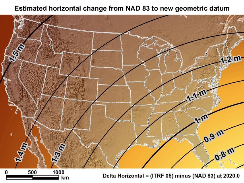
U.S. Department of Commerce
National Oceanic & Atmospheric Administration
          National Geodetic Survey
    Mission: To define, maintain & provide access to the
         National Spatial Reference System (NSRS)
to meet our Nation’s economic, social & environmental needs

             National Spatial Reference System

               * Latitude            * Scale
               * Longitude           * Gravity
               * Height              * Orientation

                 & their variations in time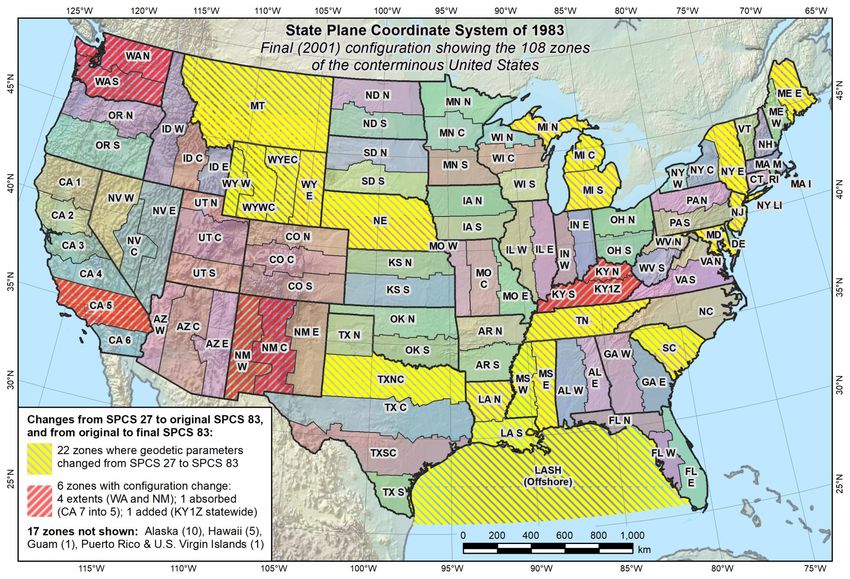
New U.S. Geometric Datums in 2022
National Spatial Reference System(NSRS)
    Improvements in the Horizontal Datums
                TIME         NETWORK                 METHOD
NETWORK         SPAN         ACCURACY               OF REFERENCE

NAD 27         1927-1986     10 meter
                                                TERRESTRIAL
                                          TRAVERSE          BASED -
                                                   & TRIANGULATION
                                          GROUNDREFERENCE  SYSTEM
                                                  MARKS USED  FOR
                                                    FOR
                                          REFERENCING    NSRS
                                                       THE NSRS.
NAD83(86)      1986-1990     1 meter

NAD83(199x)*   1990-2007     0.1 meter     TERRESTRIAL
                                          GPS           BASED REFERENCED
                                              BECOMES MEANS   OF
                                          POSITIONING – STILL
                                                  SYSTEM  FORGRND
                                                              NSRSMARKS.
  HARN

NAD83(2007)    2007 - 2011   0.01 meter
                                          GPS – CORSSPACE BASED
                                                     STATIONS ARE MEANS
 (CORS)                                          REFERENCE
                                          OF REFERENCE  FORSYSTEM
                                                            THE NSRS.
NAD83(2011)    2011 - 2022   0.01 meter              FOR NSRS

 (CORS)
NSRS Reference Basis
Old Method - Ground     New Method - GNSS Stations
Marks (Terrestrial)             (CORS)
NGS Published CORS

        Northern Chapter PLSC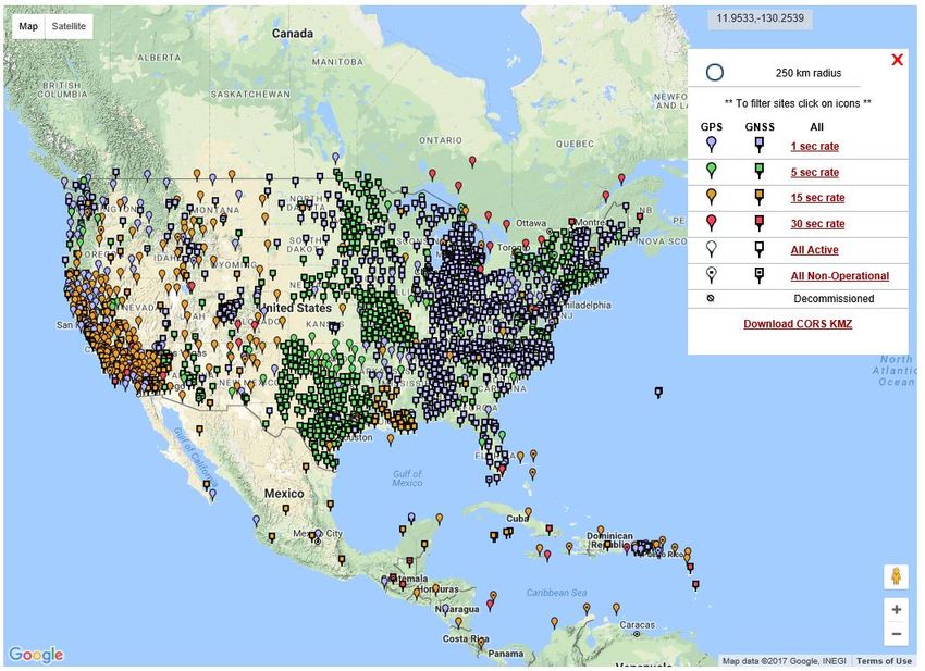
NSRS “Constrained” CORS

* Stations shown for
concept purposes only.

Why Replace NAD83?

• Datum based on best known information about the earth’s size
  and shape from the early 1980’s (≈34 years old), and the
  terrestrial survey data of the time.

• NAD83 is NON-geocentric & hence inconsistent w/GNSS (ITRF).

• Necessary for agreement with future ubiquitous positioning of
  GNSS capability.

Future Geometric (3-D) Reference Frame

  Blueprint for 2022: Part 1 – Geometric Datum

• CORS-based, accessed via GNSS observations.

• Coordinates & velocities in ITRF (IGS) & new US reference frame.

• Passive control tied to new reference frame (not a component).

• Transformation tools will relate NAD83 to new US reference
  frame (NCAT with 2022 transformation).
Datum Names
The Old:       The New:
NAD 83(2011)   The North American Terrestrial Reference Frame of 2022
                      (NATRF2022)
NAD 83(PA11)
               The Caribbean Terrestrial Reference Frame of 2022
NAD 83(MA11)           (CATRF2022)

               The Pacific Terrestrial Reference Frame of 2022
                        (PATRF2022)

               The Mariana Terrestrial Reference Frame of 2022
                       (MATRF2022)
NSRS Plate Rotation Modeling Each frame will get 3 parameters - Euler Pole Latitude - Euler Pole Longitude - Rotation rate (radians / year) This will be used to compute time-dependent TRF2022 coordinates from time-dependent IGS coordinates.
CORS Velocities – IGS08

Crustal motion to be removed by Intra Frame Velocity Models for each TRF.
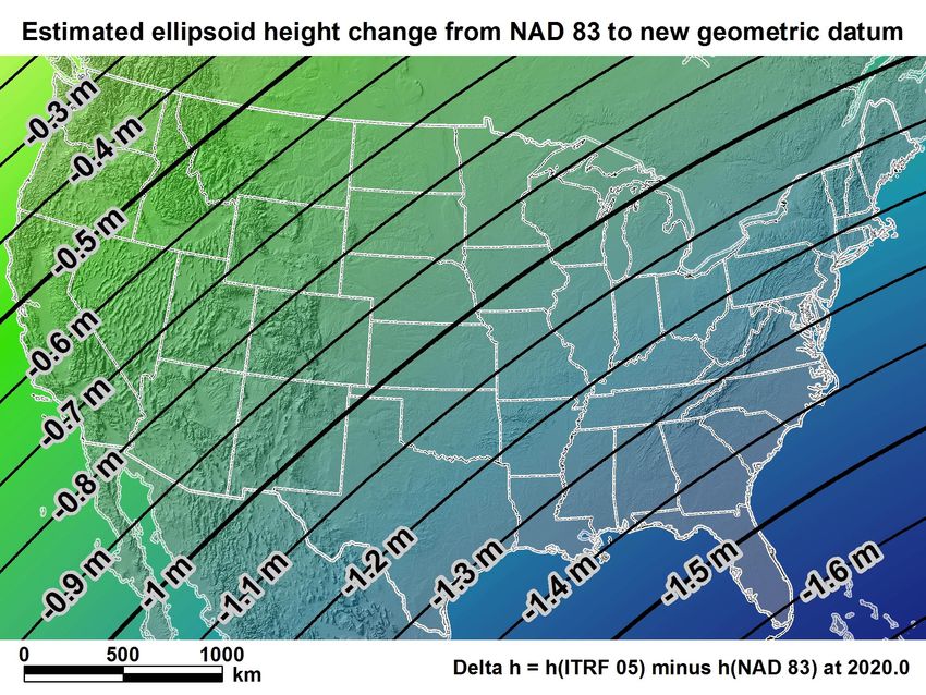
NATRF2022

New  geometric
 For Florida = 0.8 >datum   minus
                    1.02 m (2.6 > 3.3 NAD
                                      ft.) 83
                (horizontal)
NATRF2022 For Florida = -1.39 > -1.62 m (-4.5 > -5.3 ft.)
Geometric Position Epochs
Geometric Position Epochs
   NGS OPUS SOLUTION REPORT
New U.S. Vertical Datum in 2022
Why isn’t NAVD 88 good enough anymore?
* NAVD 88 is a terrestrial based vertical datum that changes as the
  land changes.

       • NAVD 88 suffers from use of bench marks that:
          – Are almost never re-checked for movement
          – Disappear by the thousands every year
          – Are not funded for replacement
          – Are not necessarily in convenient places
          – Don’t exist in most of Alaska
          – Were determined by leveling from a single point,
            allowing cross-country error build up
NEW VERTICAL DATUM (Rationale) • A move away from differentially leveled passive control as the defining mechanism of the reference surface • To be consistent with the shift in the geometric reference frame/ellipsoid (2022) • Improvement in our technical abilities in reference surface realization (geopotential gravimetric reference surface - 1cm accuracy of the geoid (GNSS/GRAV-D)) • Goal - ability to establish 2cm orthometric height anywhere in U.S. using a minimum of 15 min. of GNSS data. • The new geopotential reference surface will be aligned with the geometric reference frame/ellipsoid (i.e., no hybrid geoid)
Names
                 The Old:
Orthometric
Heights          NAVD 88
                 PRVD 02     The New:
                 VIVD09      The North American-Pacific Geopotential
Normal
Orthometric
Heights
                 ASVD02      Datum of 2022 (NAPGD2022)
                 NMVD03
                 GUVD04
Dynamic
Heights          IGLD 85
Gravity          IGSN71
Geoid
Undulations
                 GEOID12B
Deflections of
the Vertical     DEFLEC12B
Building a Gravity Field
Long Wavelengths
(≥ 250 km)
GRACE/GOCE/Satellite Altimetry +
Intermediate Wavelengths
(500 km to 20 km)
Airborne Measurement
+
Short Wavelengths
(< 100 km)
Surface Measurement and
Predicted Gravity from TopographyGravity for the Redefinition of the American
Vertical Datum (GRAV-D)
• Replace the Vertical Datum of the USA
by 2022 (at today’s funding)
• GRAV-D is:
– An airborne gravity survey of the
entire country and its holdings
– A 2022 gravimetric geoid accurate to
1 cm
– Long-term monitoring of geoid
change over time
– Partnership surveys
• Working to launch a collaborative effort
with the USGS for simultaneous
magnetic measurement
Gravity and Heights are • Acting Manager: Monica Youngman
inseparably connected Monica.Youngman@noaa.govGeoid Monitoring Service (GeMS) • Goal: Track all changes to the geoid which would prevent 1 cm accuracy • Aspects included: – Shape, Secular: e.g. Hudson Bay – Shape, Episodic: e.g. Massive Earthquakes – W0, Secular: Global Sea Level Change (see next slides) • Examples of things excluded: – Size, Secular: Mass quantity of Earth is effectively static – Shape, Periodic: Seasonal glacier cycle
Extent of 2022 gravimetric geoid model used for
                  NAPGD2022
Expected changes to orthometric heights –
NAVD88 to NAPGD2022
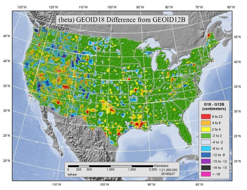
For Florida = 0.1 > -0.3 m (4 > -11 in.)NGS Products Update
GEOID 18 – Last NGS “Hybrid” Geoid Model`

Geoid 18 is being co-released with updated
 IGS14 positions on NGS published CORS
GEOID 18 – Last NGS “Hybrid” Geoid Model
NGS Products Update
Coordinate Conversion and
Transformation Tool – NCAT
    using NADCON v5.0
Other Updated NGS Products NCAT - Updated coordinate transformation program.
Prior to NCAT

                                                                                           SPC

                                                                                                      UTM
                                                                                 f, l, h
                             Region: CONUS                                2022
 USSD

                                                                                                      USNG
                                                                                            X, Y, Z
                                         GEOCON 11
NAD 27                                                        NAD 83 (2011)

         NADCON                         GEOCON

                                                        NAD 83 (NSRS2007)
NAD 83 (1986)
                                             NAD 83 (FBN)
              NAD 83 (HARN)
                                                    f, l, h
                 f, l, h

                                       X, Y, Z                      SPC
    X, Y, Z                      SPC
                                                 USNG         UTM
              USNG         UTM
Using NCAT
SPC
UTM
f, l, h
Region: CONUS 2022
USSD
USNG
NCAT (NADCON 5)
X, Y, Z
NAD 27 NAD 83 (2011)
NAD 83 (NSRS2007)
NAD 83 (1986)
NAD 83 (FBN)
NAD 83 (HARN)
f, l, h
f, l, h
X, Y, Z SPC
X, Y, Z SPC
USNG UTM
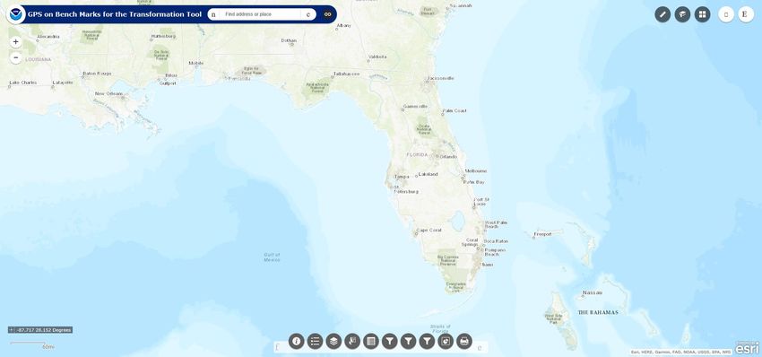
USNG UTM2022 Vertical Transformation Model – GPS on BM Project
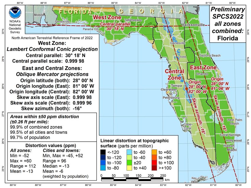
NGS Products Update
2022 State Plane Coordinate System Project
Final SPC 83 State Systems - 2001
? ? QUESTIONS ? ?

 Denis.Riordan@noaa.gov
You can also read