Development of a Navigation System Using Smartphone and Bluetooth Technologies to Help th e Visually Impaire d Navigate Work Zones Safely
←
→
Page content transcription
If your browser does not render page correctly, please read the page content below
Development of a Navigation System
    Using Smartphone and Bluetooth
Technologies to Help the Visually Impaired
       Navigate Work Zones Safely

            Chen-Fu Liao, Principal Investigator
             Department of Civil Engineering
                 University of Minnesota

                  February 2014
                     Research Project
                   Final Report 2014-12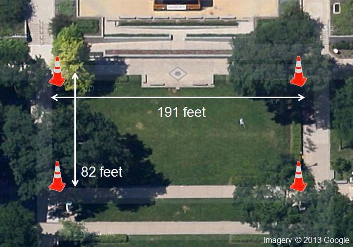
To request this document in an alternative format call 651-366-4718 or 1-800-657-3774 (Greater
Minnesota) or email your request to ADArequest.dot@state.mn.us. Please request at least one
week in advance.
Technical Report Documentation Page
1. Report No.                                  2.                               3. Recipients Accession No.
MN/RC 2014-12
4. Title and Subtitle                                                           5. Report Date
Development of a Navigation System Using Smartphone and                         February 2014
Bluetooth Technologies to Help the Visually Impaired Navigate                   6.
Work Zones Safely
7. Author(s)                                                                    8. Performing Organization Report No.
Chen-Fu Liao                                                                    CTS Project #2013027
9. Performing Organization Name and Address                                     10. Project/Task/Work Unit No.
Department of Civil Engineering
University of Minnesota                                                         11. Contract (C) or Grant (G) No.
500 Pillsbury Drive, SE                                                         (C) 99008 (WO) 66
Minneapolis, MN 55455
12. Sponsoring Organization Name and Address                                    13. Type of Report and Period Covered
Minnesota Department of Transportation                                          Final Report
Research Services & Library                                                     14. Sponsoring Agency Code
395 John Ireland Boulevard, MS 330
St. Paul, MN 55155
15. Supplementary Notes
http://www.lrrb.org/PDF/201412.pdf
16. Abstract (Limit: 250 words)

According to statistics from the Federal Highway Administration (FHWA), each year approximately 17% of all
work zone fatalities are pedestrians. People who are visually impaired often encounter physical and information
barriers that limit their accessibility and mobility. A survey was conducted among 10 visually impaired participants
as a starting point to understand their challenges and what types of information are helpful in providing bypass or
routing instructions to them around work zones. The survey results were incorporated into development of guiding
documents in determining information elements that are essential and useful for providing routing instructions to
the visually impaired around work zones. Building on our previous efforts to provide geometry and signal timing to
the visually impaired at signalized intersections, a smartphone-based navigation system was developed and
integrated with navigational audible information to alert pedestrians at decision points prior to their arrival at a
work zone. The recommended message elements from survey results were implemented in a smartphone app that
uses GPS and Bluetooth technologies to determine a user’s location. When a work zone is detected, the smartphone
will vibrate to alert users and the app will then announce a corresponding audible message to users. The visually
impaired users can perform a single tap on the smartphone to repeat the messages, if needed. Functionality testing
and system validation of the smartphone app were performed by attaching four Bluetooth beacons to light posts
near a construction site in St. Paul, MN. Additional research is needed to conduct experiments with visually
impaired users and evaluate system reliability and usefulness.

17. Document Analysis/Descriptors                                               18. Availability Statement
Audible warning devices, Work zones, Visually impaired                          No restrictions. Document available from:
persons, Smartphones, Bluetooth technology                                      National Technical Information Services,
                                                                                Alexandria, Virginia 22312

19. Security Class (this report)               20. Security Class (this page)   21. No. of Pages              22. Price
Unclassified                                   Unclassified                     87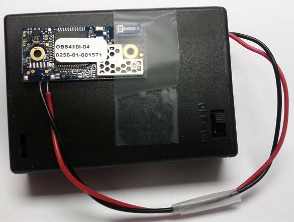
Development of a Navigation System Using Smartphone and
  Bluetooth Technologies to Help the Visually Impaired
              Navigate Work Zones Safely

                                                 Final Report

                                                  Prepared by:

                                             Chen-Fu Liao
                                Minnesota Traffic Observatory Laboratory
                                    Department of Civil Engineering

                                               February 2014

                                                 Published by:

                                 Minnesota Department of Transportation
                                      Research Services & Library
                                  395 John Ireland Boulevard, MS 330
                                          St. Paul, Minnesota

This report documents the results of research conducted by the authors and does not necessarily represent the views
or policies of the Minnesota Department of Transportation or the University of Minnesota. This report does not
contain a standard or specified technique.
The authors, the Minnesota Department of Transportation, and the University of Minnesota do not endorse products
or manufacturers. Trade or manufacturers’ names appear herein solely because they are considered essential to this
report.
ACKNOWLEDGEMENTS

This work was supported by the Minnesota Department of Transportation (MnDOT). The
author would like to thank members of the Technical Advisory Panel (TAP) for
providing feedback and guidance on this project. The author thanks the visually impaired
participants for their survey. The author also would like to recognize the following
people and organizations for their invaluable assistance in making this research possible.

   •   Kaushiki Nag and Kaustubh Duraphe, Department of Computer Science,
       University of Minnesota (UMN)
   •   Ken Johnson, MnDOT
   •   Monica Beeman, City of St. Paul Public Works
   •   Rik Myhre, JE Dunn Construction
   •   Gordon Legge, Department of Psychology, UMN
   •   Vision Loss Resources (VLR), Inc., Minneapolis
   •   Minnesota Traffic Observatory (MTO), UMN
   •   Center for Transportation Studies (CTS), UMN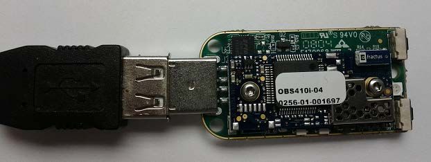
TABLE OF CONTENTS

CHAPTER 1. INTRODUCTION ...................................................................................... 1
 1.1 Research Objectives .................................................................................................. 1
 1.2 Literature Review ...................................................................................................... 1
    1.2.1 Work Zone Mobility for People with Disabilities.............................................. 2
    1.2.2 Auditory Navigation........................................................................................... 4
    1.2.3 Verbal Guidance and Usability for the Blind..................................................... 5
 1.3 Report Organization .................................................................................................. 6

CHAPTER 2. SURVEY .................................................................................................... 7
 2.1 Audible Messages ..................................................................................................... 7
 2.2 Survey Results ........................................................................................................... 9
 2.3 Recommended Elements for Audible Work Zone Messages ................................. 13

CHAPTER 3. SYSTEM DESIGN AND DEVELOPMENT ........................................... 14
 3.1 Spatial Database ...................................................................................................... 14
 3.2 Audible Messages ................................................................................................... 16
 3.3 Smartphone App ..................................................................................................... 16
 3.4 Bluetooth Beacons .................................................................................................. 17

CHAPTER 4. SYSTEM TESTING AND VALIDATION.............................................. 21
 4.1 Functionality Testing .............................................................................................. 21
 4.2 System Validation ................................................................................................... 22
    4.2.1 Testing of Bluetooth Communication Range................................................... 22
    4.2.2 North Construction Site (9/9/13 – 10/2/13) ..................................................... 23
    4.2.3 South Construction Site (10/7/13 – 10/25/13) ................................................. 25

CHAPTER 5. FUTURE WORK ...................................................................................... 28
 5.1 Proposed System Architecture for Future Implementation ..................................... 28
    5.1.1 PC Based Data Entry........................................................................................ 28
    5.1.2 Smartphone-Based Data Entry ......................................................................... 29
 5.2 Future Work ............................................................................................................ 30

CHAPTER 6. SUMMARY AND CONCLUSION ......................................................... 31

REFERENCES.................................................................................................................. 33

Appendix A: Participant Recruitment Ad and Consent Form
Appendix B: Experiment Protocol and Interview Questionnaires
Appendix C: Database Interface for Work Zone Bluetooth Beacons
Appendix D: Java Code Structure Examples
Appendix E: ConnectBlue™ Programming Interface
Appendix F: Other Hardware Components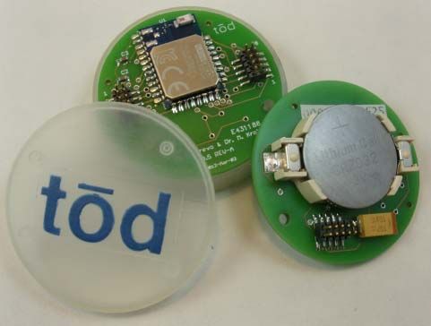
LIST OF FIGURES

Figure 2-1 Self-Reported Travel Skills .............................................................................. 9
Figure 2-2 Importance of Work Zone Information .......................................................... 10
Figure 2-3 Clearness of Message ..................................................................................... 10
Figure 2-4 Understanding of the Message ....................................................................... 11
Figure 2-5 Remembrance of Intersection or Street Name ............................................... 11
Figure 2-6 Likelihood to Try Suggested Route................................................................ 12
Figure 3-1 Bluetooth Database System ............................................................................ 15
Figure 3-2 Flowchart of Work Zone Navigation Smartphone App ................................. 17
Figure 3-3 Illustration of Bluetooth Beacon Placement at Decision Points around a Work
Zone................................................................................................................................... 18
Figure 3-4 A Bluetooth Beacon Prototype Powered by 3 AA Batteries .......................... 19
Figure 3-5 tōd Smart Beacon using Bluetooth 4.0 Technology ....................................... 19
Figure 4-1 Testing locations on UMN campus ................................................................ 21
Figure 4-2 Bluetooth Beacon Prototype and Enclosure ................................................... 22
Figure 4-3 Configuration of Bluetooth Communication Range Testing ......................... 23
Figure 4-4 Testing at State Capitol North Construction Site ........................................... 24
Figure 4-5 Installation of Bluetooth Beacon and Field Testing (North Sidewalk) .......... 25
Figure 4-6 Testing at State Capitol South Construction Site ........................................... 26
Figure 4-7 Installation of Bluetooth Beacon and Field Testing (South Sidewalk) .......... 26
Figure 5-1 Proposed System Architecture for Future Implementation ............................ 28
Figure 5-2 Proposed Smartphone App to Update Bluetooth Database ............................ 29
Figure C-1 Bluetooth Database Editing Interface .......................................................... C-1
Figure E-1 Connectblue USB Programming Interface .................................................. E-1
Figure E-2 ConnectBlue™ Graphical User Interface – Select Product ......................... E-1
Figure E-3 ConnectBlue™ Graphical User Interface – Connection .............................. E-2
Figure E-4 ConnectBlue™ Graphical User Interface – Programming .......................... E-2

                                                  LIST OF TABLES
Table 1-1       Linguistic Forms and Guidance Functions ........................................................ 4
Table 3-1       Data Scheme of Spatial Database .................................................................... 16
Table 4-1       Test Results of Bluetooth Communication Range (OBS410i Module)........... 23
Table C-1       Data Fields of Tables in MySQL Database .................................................. C-4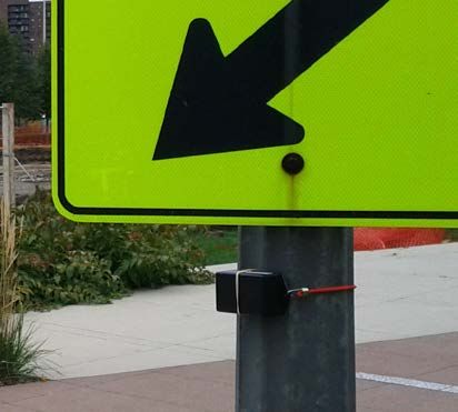
LIST OF ACRONYMS AND ABBREVIATIONS

ADA        American Disability Act
ALF        Automatic Location Finder
App        Application Software for Mobile Device
APS        Accessible Pedestrian Signal
ATSSA      American Traffic Safety Services Association
BT         Bluetooth
CALTRANS   California Department of Transportation
COMS       Certified Orientation and Mobility Specialist
CTS        Center for Transportation Studies
CWA        Cognitive Work Analysis
DB         Database
DSCC       Disabled Student Cultural Center
DSRC       Dedicated Short Range Communications
DSS        Digital Sign System
dB         Decibels
EID        Ecological Interface Design
FHWA       Federal Highway Administration
GIS        Geographic Information System
GPS        Global Positioning System
GUI        Graphical User Interface
HAR        Highway Advisory Radio
IDE        Integrated Development Environment
IEEE       Institute of Electrical and Electronics Engineers
IMEI       International Mobile Equipment Identity
I/O        Input / Output
IRB        Institutional Review Board
KB         Kilo Byte
ITS        Intelligent Transportation Systems
LBS        Location Based Service
MAC        Media Access Control
MAPS       Mobile Accessible Pedestrian Signal
MAX        Maximum
MnDOT      Minnesota Department of Transportation
MTO        Minnesota Traffic Observatory
MUTCD      Manual on Uniform Traffic Control Devices
mW         Milli-Watts
NCHRP      National Cooperative Highway Research Program
NEMA       National Electrical Manufacturers Association

OEM    Original Equipment Manufacturer
OS     Operation System
O&M    Orientation and Mobility
PC     Personal Computer
RFID   Radio Frequency Identification
RITA   Research & Innovative Technology Administration
SD     Standard Deviation
SQL    Structured Query Language
TAP    Technical Advisory Panel
TPAR   Temporary Pedestrian Access Route
TTC    Temporary Traffic Control
TTS    Text To Speech
UI     User Interface
UMN    University of Minnesota
USB    Universal Serial Bus
VA     Veteran Affairs
VIS    Vision Impairment Services
VLR    Vision Loss Resources
VPN    Virtual Private Network
WDA    Work Domain Analysis
WZ     Work Zone
EXECUTIVE SUMMARY

According to statistics from the Federal Highway Administration (FHWA), each year
approximately 17% of all work zone fatalities are pedestrians. People who are visually impaired
often encounter physical and information barriers that limit their accessibility and mobility.

The Minnesota Department of Transportation (MnDOT), the American Traffic Safety Services
Association (ATSSA) and the local Northland Chapter of ATSSA jointly organized a Temporary
Pedestrian Access Route (TPAR) Workshop and Demonstration on June 23‐24, 2010. The
purposes were to (1) collect information regarding pedestrian work zone detouring experiences
from people with disabilities and mobility instructors and (2) use the information to develop
guidelines for temporary traffic control planning and design.

In June 2011, ATSSA in coordination with the FHWA and the California Department of
Transportation also hosted a temporary pedestrian access and mobility demonstration in
Sacramento, California. A practitioner guide was published in 2012 to provide state and local
practitioners with guidance on how to design temporary traffic control plans that address
pedestrian access to better meet the needs of people with disabilities.

Key findings from both workshops emphasized the need to provide adequate audible messages
for people with vision impairment. The workshops concluded that audible messages for a
temporary pedestrian route shall include a complete physical description of the temporary
pedestrian route including duration, length of and distance to the by-pass, any restrictions or
hazards and project information.

The objective of this study is to evaluate the use of a smartphone app and Bluetooth beacons to
provide work zone information to visually impaired travelers. Needs analysis was first assessed
to understand current challenges and what information may be needed to improve mobility. A
smartphone-based accessible pedestrian navigation system was designed to incorporate user
needs from survey results. The app was intended to take advantages of sensors already embedded
on smartphones and the Bluetooth technology to effectively provide bypass or routing
information to the visually impaired while they are approaching a work zone.

A survey was conducted among a small group of visually impaired participants as a starting
point to understand their challenges and what types of information are helpful in providing
bypass or routing instructions to them while approaching work zones. Survey results were
analyzed to develop guidelines in determining various message elements that are essential and
useful for providing routing instructions to the visually impaired at work zones. Four audible
message elements are recommended and summarized as follows.
1.   Brief announcement to get pedestrian’s attention
   2.   Current location of a pedestrian
   3.   What and/or where (such as accessible path availability and construction duration)
   4.   Advisory action

A sample message follows the recommended information elements is described as follows.
   • Attention eastbound Washington Avenue pedestrians.
   • You are at southeast corner of Washington and Church.
   • Road construction on Washington from Church Street to Huron for 7 blocks.
   • Protected pedestrian path open on this side.

A smartphone app based on the Android operation system was developed for providing audible
messages to people with vision impairment at a work zone. Global positioning system (GPS),
Bluetooth technology, text to speech (TTS) interface, and digital compass already equipped on a
smartphone were integrated with a digital map in the smartphone app. The smartphone app will
communicate Bluetooth beacons installed near a work zone to help determine a user’s location
and provide corresponding navigational guidance instructions.

Bluetooth beacons were programmed to operate in discovery mode with minimal power
consumption. The navigation program runs continuously in the background as a service on the
smartphone. The smartphone app will continuously scan for Bluetooth devices in the vicinity and
identify available information related to work zone and/or signalized intersection by comparing
the identification (ID) of detected Bluetooth beacons with a spatial database.

The work zone navigation app was also integrated with the intersection crossing app previously
developed. When a Bluetooth beacon contains work zone and intersection geometry information,
the app will first announce corresponding work zone messages and then provide intersection
information (street name and number of lanes) based on the direction that the smartphone is
pointing to.

Functionality testing and system validation of the smartphone app were performed by attaching 4
Bluetooth beacons to light posts near a construction site in St. Paul, MN. A research student
carried the smartphone with the app and walked around the test sites repeatedly from different
directions to validate the audible messages, Bluetooth communication and other user interface.
The validation result confirms that the smartphone vibrated for about one second and announced
the corresponding audible message to the traveler as a user was walking toward a Bluetooth
beacon.
Additional research is needed to conduct experiment with visually impaired users and evaluate
system reliability and usefulness. An implementation study is essential and needs to be robust in
terms of numbers of participants and needs to be completed at different work zones with
different configurations. Data can be recorded and analyzed in terms of travel time, number of
correct/incorrect responses/movement, understanding, safety and user confidence.

According to a reserch survey conducted by Pew Research Center in 2013, 55% of cell phone
owners say that their phone is a smartphone. Although, the smartphone ownership in the visually
impaired community is lower than that in the general population. Five of the ten visually
impaired participants we surveyed own a smartphone. It is expected that smartphone ownership
will continute to increase as the mobile technology advances in the near future. The work zone
nagivation app will become more widely accessible to users as the public agencies advance the
implementation.
1. INTRODUCTION

Each year approximately 17% of all work zone fatalities are pedestrians. In addition to federal
guidelines, MnDOT has invested significant amount of effort to accommodate pedestrians,
particularly for those with disabilities, in temporary traffic control situations to ensure safe and
effective movement. People who are visually impaired often encounter physical barriers that
limit their accessibility and mobility. Building upon our previous study on providing geometry
and signal timing to the visually impaired at signalized intersections, a smartphone-based
navigation system was developed to assist the visually impaired pedestrians to navigate work
zones safely.

1.1 Research Objectives
The objectives of this project are to: (1) understand what types of information are helpful in
providing bypass or routing instructions to the visually impaired around work zones, (2) provide
recommendations on key elements of accessible messages that will be useful for the visually
impaired, and (3) develop a smartphone-based system to alert pedestrians with the necessary
information in advance of the visually impaired approaching a work zone at decision points. The
proposed research will help develop standardized message format for conveying work zone
bypass or routing instructions to pedestrians. The proposed system aims to improve the ability of
the visually impaired to travel independently and safely around work zones.

1.2 Literature Review
Federal and state work zone guidelines and standards require that pedestrian travel be
accommodated in work zones. People with vision impairment are more vulnerable to collision
due to insufficient information (such as distant and heading) and time for planning detour around
obstacle (Loomis et al., 2001, 2007). The Americans with Disability Act (ADA) requires that the
built in environment be accessible to people with disability (Bentzen, 2007). Individuals with
wayfinding difficulties, such as those that are visually impaired (Golledge et al., 1996; Helal et
al., 2001), elderly people (Rogers et al., 1998; Kirasic, 2002; Hess, 2005), and those with
dementia or Alzheimer's diseases (Uc et al., 2004; Rosenbaum et al., 2005; Pai 2006), can
benefit from a personal navigation system for wayfinding assistance. There have been numerous
studies on using Geographic Information System (GIS) and Global Positioning System (GPS)
based navigation system for visually impaired travelers (Golledge, et al., 1991, 1996, 1998,
2004; Helal et al., 2001; Ponchillia et al., 2007; Blake, 2011). Several researchers also focused
on the development of User Interface (UI) with non-visual spatial displays, for example, haptic
(Loomis et al., 2005 & 2007; Marston et al., 2007), auditory (Loomis et al., 1998; Kim et al.,
2000; Marston et al., 2007), or virtual acoustic display (Kim and Song, 2007), in order to provide
perceptual information about the surrounding environment.

                                                  1
1.2.1 Work Zone Mobility for People with Disabilities
According to statistics from the Federal Highway Administration (FHWA), each year
approximately 17% of all work zone fatalities are pedestrians. Since the ADA was enacted in
1990, there has been growing emphasis from both federal and local transportation agencies to
provide safe pedestrian access in and around work zones. The ADA requires that pedestrians
with disabilities be accommodated in completed facilities as well as during times of construction.
Pedestrian movements around work zone areas require proper planning and consideration in
order to avoid conflicts with work site equipment, vehicles and operations. The Manual on
Uniform Traffic Control Devices (MUTCD) published by the FHWA and the Minnesota
MUTCD (part 6) provide specific guidelines for Temporary Traffic Control (TTC) in work zones
and outline specific requirements to accommodate pedestrians with disabilities. One of the
requirements is, for example, to provide audible information for the visually impaired.
Temporary Pedestrian Access and Mobility
The Minnesota Department of Transportation (MnDOT), the American Traffic Safety Services
Association (ATSSA) and the local Northland Chapter of ATSSA jointly organized a Temporary
Pedestrian Access Route (TPAR) Workshop and Demonstration on June 23‐24, 2010. The
purposes were to, (1) collect information regarding pedestrian work zone detouring experiences
from people with disabilities and mobility instructors, and (2) use the information to develop
guidelines for temporary traffic control planning and design (MnDOT, 2010).
In June 2011, ATSSA in coordination with the FHWA and the California Department of
Transportation (CALTRANS) also hosted a temporary pedestrian access and mobility
demonstration in Sacramento, California. The objective was to provide state and local
practitioners with guidance on how to design temporary traffic control plans that address
pedestrian access to better meet the needs of people with disabilities. The final guideline is
currently under review by the FHWA and is expected to be published in early 2013.
Key findings from both workshops emphasize the need to provide adequate audible messages for
people with vision impairment. They concluded that audible messages for a temporary pedestrian
route shall include a complete physical description of the temporary pedestrian route including
duration, length of and distance to the by-pass, any restrictions or hazards and project
information.
Pushbutton or motion-activated audible devices are also commercially available. For example,
Empco-Lite (http://www.empco-lite.com) and the ADA Pedestrian Audible Alert System from
MDI Traffic Control Products (http://www.mditrafficcontrol.com/) use pre-recorded messages at
selected locations around a work zone to inform approaching pedestrians about the construction
and provide specific routing information. The MDI system can automatically adjust volume to
compensate ambient noises. However, there are concerns over the consistency of message
2elements and clarity of audible messages. Ullman & Trout (2009) emphasized the importance of
clear audible messages and spatial message elements that are critical in guiding the visually
impaired pedestrians along a temporary route and supporting navigation in a less familiar
environment. However, information overload could be a concern as most people may have
difficulties in memorizing long verbal messages accurately. Transportation engineers and
practitioners often face the challenges between verbosity and efficiency of auditory messages.
Auditory Messages for the Visually Impaired
The MUTCD clearly states that auditory messages should be used in and around work zone for
people with disabilities; however, there is limited guidance available on auditory message
structure and elements. Currently, there is insufficient guidance on how the audible message
should be formatted to support wayfinding for the visual impaired around work zones.
For example, Bentzen et al. (2002) recommended speech message structure and wording for
Accessible Pedestrian Signals (APS). Hine et al. (2000) developed an auditory location finder
(ALF) that involved auditory message content, structure, route choice, orientation, landmarks,
and clues. Giudice et al. (2007) studied spatial learning and navigation using dynamically
updated verbal messages and employed a geometric-based display consisting of three verbal
modes (local, maplet, and global). They concluded that dynamically updated verbal descriptions
are an effective medium in describing environmental relations and support spatial learning in
unfamiliar environments (Giudice et al., 2007).
In addition, Ullman & Trout (2009) explored different audio message elements and investigated
how the guidance and warning messages were being understood by the visually impaired. They
identified number of units of information in each message based on Highway Advisory Radio
(HAR) message guidance as outlined by Hutchingson et al. (1982). Ullman & Trout (2009) first
conducted a survey then performed a field test using a motion–activated audible device to
evaluate the effectiveness of messages for navigating around a work zone. They concluded that
(1) it is important to design a clear, simple and concise message, (2) initial turning or crossing
instruction and travel distance (preferably using blocks for long distance and feet for shorter
distance) are critical message elements for navigating an alternate route, and (3) there is a
concern on information overload.
Sample audible messages used by Ullman & Trout (2009) are listed as follows.
• “Attention northbound Clark Avenue pedestrians. Sidewalk closed. To avoid closed area,
cross Clark Avenue at next intersection. Turn right and continue six blocks on opposite
side of street. Return to original side of street if desired.” – 7 units of information
• “Attention eastbound Orchard Road pedestrians. Construction ahead. To avoid
construction area, cross at Green Street and turn left. Continue on opposite side of street
for the next 1⁄2 mile.” – 5 units of information
3Gaunet and Briffault (2005) and Gaunet (2006) studied guidance instructions and spatial
information through navigational experiments in both simple structured and complex
unstructured urban areas. They used six categories of guidance functions to structure linguistic
forms for synthesizing the perceptual and environmental information. They suggested that detail
level of description and precision of localization must be improved in order to provide guidance
in complex urban environments. Information and instruction guidance functions used by Gaunet
and Briffault (2005 & 2006) are outlined as follows.
Information guidance functions:
• Location and Orientation (LO)
• Goal Location (GL)
Instruction guidance functions:
• Orientation (O)
• Crossing (C)
• Route Ending (RE)
• Progress (P)
Examples of linguistic forms and guidance functions (Gaunet, 2006):
Table 1-1 Linguistic Forms and Guidance Functions
Linguistic Forms Guidance Functions
You are in front of “XXX Café” LO: Location / Orientation
Walk forward P: Progression
Turn to the right O: Orientation
Arrive at XXX intersection RE: Route Ending
1.2.2 Auditory Navigation
Due to the heavy visual demands on a driving task, auditory route guidance has safety advantage
over the visual display. The impact of driver’s performance while obtaining auditory and/or
visual guidance has been studied in vehicle navigation (Campbell et al. 1998), in-vehicle display
(Campbell et al, 2004), and speed advisory (Shahab et al. 2010). Improved driving performance
and reduced driver’s workload were found in route guidance systems (RGS) incorporating both
visual and auditory guidance as compared to those using electronic map alone (Srinivasan &
Jovanis, 1997). Streeter et al. (1985) reported that auditory navigation in their experiment is
easier than the visual format. However, Walker et al. (1990) found that complicated auditory
information such as spatial layouts interfered with participants’ information processing
capabilities.
4The human factor design guidelines for advanced traveler information systems (Campbell et al.,
1998) suggested presenting the information in the order of importance or relevance and
providing a feature for repeating the audio message. Campbell et al. (1998) also recommended
that auditory navigation instructions should be limited to 3 or 4 information units for drivers.
Morley et al. (1999) designed and evaluated a non-visual hypermedia system for blind users.
Hypermedia is a network of information which comprises of text, images, sound recordings
(even tactile and olfactory outputs). The World Wide Web is a well-known example of a
hypermedia environment. Morley et al. (1999) concluded that user interface should be simple,
easy to learn, consistent and provide effective feedback. Boer de (2008) suggested using short
auditory messages with natural tone and familiar voices to improve the effectiveness in
navigating people with mild dementia.
1.2.3 Verbal Guidance and Usability for the Blind
Gaunet and Briffault (2005) developed a set of verbal guidance rules for assisting visually
impaired pedestrians in navigating through urban areas. Gaunet (2006) conducted navigational
experiments in simple structured, and complex unstructured urban areas. The findings offer
interesting perspectives for guidance rules originating from verbal instructions given to visually
impaired pedestrians. Gaunet suggested that these instructions could also be used by sighted
users with a few specific modifications.
Roentgen et al. (2011) evaluated four electronic navigational devices for the visually impaired.
Five-point scale of D-Quest (Wessels & de Witte, 2003) based questionnaire in seven aspects
(dimension, weight, adjustment, safety, simplicity, comfort, and effectiveness) was used in
combination with open questions to access 18 participants’ subjective experiences. They
concluded that participants’ preferences regarding device usability and functionality linked
closely with individual’s O&M and computer skills, and their knowledge and expectations of the
devices’ functional ability (Roentgen et al., 2011).
Havik et al. (2011) evaluated the effectiveness of different types of verbal information provided
by electronic travel aids in assisting wayfinding performance among 24 visually impaired users.
The results suggested that a combination of route and environmental information are preferred
by the participants, even though the combined information did not always result in an optimal
wayfinding performance. They recommended including distance information to next information
point and more landmarks or information points in the environment.
Wilson et al. (2007) developed a wearable audio navigation system to assist blind and visually
impaired people getting from origin to destination. The system uses GPS, digital compass,
cameras, and a light sensor to transmit 3D audio cues to guide the traveler along a path to
destination. They concluded that the auditory interface has proven itself to be simple,
5straightforward, and effective in guiding uses along both simple and complex paths (Wilson et
al., 2007).
Davies and Burns (2008) reviewed recent advances in Cognitive Work Analysis (CWA) and
Ecological Interface Design (EID) for visual and auditory displays. Davies et al. (2006)
developed a prototype design of an auditory interface based on the Work Domain Analysis
(WDA) of EID for people who are visually impaired. Usability test of the prototype was
performed to evaluate the effectiveness of object identification, direction of obstacle, and
determining relative size and distance of an object (Davies et al., 2007). Sanderson et al. (2000)
proposed additional hierarchy layer to extend EID for auditory design.
1.3 Report Organization
The rest of this report is organized as follows. A questionnaire was designed and discussed in
Section 2 to better understand what message elements are important and useful for the visually
impaired while navigating around work zones. Design and development of a smartphone app and
Bluetooth beacon interface are included in Section 3. System testing and validation are presented
in Section 4. Lesson learned and future works are discussed in Section 5. Finally, summary is
presented in Section 6.
62. SURVEY
To better understand what message elements are important and useful for the visually impaired
while navigating around work zones, a survey protocol was designed and reviewed by the
University of Minnesota (UMN) Institutional Review Board (IRB). The recruitment ads and
survey materials were approved by the UMN IRB with reference code #1209S21382.
The research team has been working closely with local blind communities, including the Vision
Loss Resources, Inc. (VLR) in Minneapolis, UMN disability student group, and Vision
Impairment Service (VIS) group at VA hospital. The recruiting ad (see Appendix A) was
announced in VLR’s monthly newsletter and also distributed through email to disability student
group though Disabled Student Cultural Center (DSCC) at UMN. The approved consent form,
listed in Appendix B, was used to ensure participants understand the objectives of this research
and the purposes of the survey prior to their participations in survey discussion. Interview
protocol and survey questionnaires (see Appendix C) were used to collect navigational
information and comments from the pedestrians who are visually impaired while wayfinding
around work zones.
2.1 Audible Messages
The research team has interviewed 10 visually impaired pedestrians (in-person) to understand
what type of information is helpful in providing work zone routing information to them. In
addition to demographic information, four different messages with various level of information
content were programmed and announced using synthetic speech voice, i.e., text to speech
(TTS), to each participant during the survey.
• Message #1
“Attention eastbound Dolphin Street pedestrians. Construction ahead on sidewalk
between 2nd and 6th Avenue. Use alternate route.”
• Message #2
“Attention southbound Lyndale Avenue pedestrians. East sidewalk closed from 22nd to
26th street. Cross Lyndale. Use sidewalk on the other side.”
• Message #3
“Attention southbound Snelling Ave pedestrians. Sidewalk closed from Marshall Ave for
6 blocks. Cross Snelling at Marshall. Use sidewalk on the other side. Return to original
side of street if desired”
• Message #4
Part 1 - “Attention southbound Lyndale Avenue pedestrians. You are at southwest corner
of Lyndale and Franklin. West sidewalk closed from 22nd to 26th street. Cross Lyndale
for more bypassing message.”
7Part 2 - “Attention southbound Lyndale Avenue pedestrians. You are at southeast corner
of Lyndale and Franklin. West sidewalk closed from 22nd to 26th street. Use sidewalk on
this side.”
82.2 Survey Results
The survey results were summarized as follows.
• 5 participants have no vision at all and the other 5 participants have low vision
• 3 participants are males and the other 7 are females
• Regarding to highest level of education, 1 participant graduated from high school, 5
participants received a bachelor’s degree, and the other 5 obtained a master’s degree.
• Average length of blindness is 34 years (SD 29 years)
• Average age is 55.6 years (SD 12.5 years)
• Average length of using cane for assistance is 26.5 years (SD 23 years)
• Average length of using guide dog is 13.8 years (SD 13.6 years)
• When traveling in a familiar environment, 4 participants prefer using cane for assistance,
4 participants prefer using guide dog, and the other 2 participants, with limited vision,
does not need assistance.
• When receiving audible detour or bypassing information nearby a work zone, 2
participants prefer complete detour or bypassing message at a starting location, 7
participants prefer sequential turn-by-turn audible guidance message at key decision
points, and the other participant would like to have both information.
• 5 participants use regular mobile phones, 4 participants have smartphone, and the other
one does not have a mobile phone.
• Only one participant out of the 4 smartphone owners uses mobile GPS navigation system
on the smartphone.
• As regard to technology proficient in general on the scale from 1 to 5, the participants
gave an average score of 4.0 with standard deviation of 1.2.
Figure 2-1 Self-Reported Travel Skills
9• Self-reported travel skills (on the scale from 1 to 5), displayed in Figure 2-1.
• Importance of work zone information (on the scale from 1 to 5), displayed in figure 2-2
Figure 2-2 Importance of Work Zone Information
• Clearness of message (on scale 1 to 5, 1 – very unclear, 3 – neutral, 5 very clear),
displayed in Figure 2-3
Figure 2-3 Clearness of Message
10• Understanding of the message, displayed in Figure 2-4
Figure 2-4 Understanding of the Message
Most of the participants reported that they understood the message as display in Figure 2-4.
However, three participants did not remember what street or intersection the message #1 was
talking about. As illustrated in Figure 2-5, one participant cannot recall the intersection in
message #2 and two participants did not remember which intersection that message #3 referred
to.
Figure 2-5 Remembrance of Intersection or Street Name
11• In all messages, participants were able to identify the sidewalk was closed or there was a
construction in the vicinity.
• Try suggested route (on scale 1 to 5, 1 – absolutely no, 3 – neutral, 5 – absolutely yes),
displayed in Figure 2-6.
Figure 2-6 Likelihood to Try Suggested Route
• In general, the participants will follow the detour instruction or try to find an alternate
route if no further information was provided in the audible messages. They trust the
message and will avoid the construction area as instructed for the sake of their own
safety.
• When receiving audible direction information, 6 participants prefer cardinal (such as
north, south, east, or west) direction, 2 participants prefer clock phase direction, and the
other 2 participants have no preference.
• When receiving audible location information, 2 participants like landmark, 6 participants
prefer street name, and the other 2 have no preference.
• When hearing an audible message, 4 participants prefer male voice, 1 prefers female
voice, and the other 5 participants have no preference.
• All participants (10) reported that the synthetic voice is clear. 2 participants reported the
compute speech is a bit too slow, 2 felt it’s a bit too fast, and the other 6 participants felt
the speed is just fine.
• All participants reported that it is extremely important to include a feature for repeating
the audible message as many times as needed.
• In addition to work zone information, some participants reported that they also would like
to know if the intersection has a stop light or other key landmark around them.
122.3 Recommended Elements for Audible Work Zone Messages
Survey results were analyzed to develop guidance documents in determining various message
elements that are essential and useful for providing routing or bypassing work zone instructions
to the visually impaired. Proposed audible message elements are listed as follows.
• Brief announcement to get pedestrian’s attention
• Current location of a pedestrian
• What
• Where, (accessible path availability and event duration)
• Advisory action
Message example #1
Attention southbound Lyndale Avenue pedestrians.
You are at southwest corner of Lyndale and Franklin.
West sidewalk closed from 22nd to 26th street for 4 blocks.
Cross Lyndale for more bypassing message.
Message example #2
Attention eastbound Washington Avenue pedestrians.
You are at southeast corner of Washington and Church.
Road construction on Washington from Church St to Huron for 7 blocks
Protected pedestrian path open on this side.
133. SYSTEM DESIGN AND DEVELOPMENT
A smartphone app based on Android operation system (OS) was developed to provide audible
messages to people with vision impairment while approaching a work zone. The purpose is to
help the visually impaired pedestrians safely navigate through or around construction areas.
Global positioning system (GPS), Bluetooth technology, text to speech (TTS) interface, and
motion sensors equipped on a smartphone were integrated with a digital map and Bluetooth
beacons to help identify a user’s location and provide navigational guidance.
Bluetooth beacons can be easily attached to barricades or traffic cones at decision points to help
determine the location of a user. The smartphone app, after detecting a Bluetooth beacon in
discovery mode, will provide associated navigation messages to travelers. The navigation
program runs continuously in the background as a service on the Android smartphone. It will
continuously scan for Bluetooth devices in the vicinity and identify available information related
to work zone and signalized intersection by comparing the ID of detected Bluetooth beacons
with the spatial database. When any work zone information is detected, the app will alert users
with a brief vibration (about 1-sec) and announce corresponding audible messages through the
TTS interface. Users can then perform a single-tap on the screen of a smartphone to repeat
announced audible message, if desired.
The work zone navigation system consists of three key components, i.e., a digital map database
for spatial reference, a smartphone app, and Bluetooth smart beacons. User input is implemented
by performing a single-tap on the smartphone screen for repeating audible messages. Vibration
and audible feedback are provided to users when a Bluetooth beacon is detected.
The general geometry information of a work zone area, location of Bluetooth devices, and
associated advisory messages can be easily programmed and uploaded to the spatial database
through a web interface (See Appendix A). The web interface will allow engineers to deploy
accessible audible messages around a work zone quickly and easily. The smartphone app was
developed using the open source Java technology in Eclipse-based integrated development
environment (IDE). In the future, the same app can be developed for other smartphones (e.g.,
iPhone iOS, Windows phone, etc.) running on mobile OS other than Android. Several prototypes
of Bluetooth beacons were developed and programmed using OEM Bluetooth modules
(SPA310i and OBS410i) manufactured by the ConnectBlue Inc. The Bluetooth beacon
prototypes are powered by three AA batteries.
3.1 Spatial Database
An open source database server, mySQL, is setup and configured to provide digital map
reference to smartphone clients based on a user’s current location. Location based spatial
information, for example, covers 5-mile radius around a smartphone user, will be periodically
14updated in an embedded database (SQLite) residing on the smartphone to ensure continuous map
coverage. Media access control (MAC) address of individual Bluetooth module, latitude-
longitude location, and other spatial information are included in each record of the spatial
database. In addition, a Java application was developed on the server side to facilitate the process
of creating spatial data records and updating work zone location with corresponding information
(See Appendix C for detailed description).
The 3-tier Bluetooth database system design is illustrated in Figure 3-1.The middle tier (servlet)
application handles the data transaction between the client applications (the PC graphical user
interface (GUI) program or the smartphone app) and the SQL database server. Sample servlet
code is included in Appendix D. The work zone smartphone app will download spatial data from
the Bluetooth database server within +/-7 miles (or +/- 0.1 degree in both latitudinal and
longitudinal directions) when the app was started initially. The app will continue monitor current
GPS location and update the local database on the phone every 15 minutes. The smartphone will
always have +/- 7 miles of reference data coverage in case the cellular network is temporary out
of service. Currently, the smartphone app uses relatively small memory space (in the range of
100 KB to 200 KB) on the smartphone.
MySQL DB
Servlet
Bluetooth DB PC WZ Pedestrian
User Interface Navigation App
Update Bluetooth DB Work Zone Pedestrian
from a PC Navigation Smartphone App
Figure 3-1 Bluetooth Database System
153.2 Audible Messages
Proposed audible message elements resulting from survey in task #2 are listed as follows.
• Brief announcement to get pedestrian’s attention
• Current location of a pedestrian
• What and where, (accessible path availability and event duration)
• Advisory action
The data scheme implemented in the spatial database, as listed in Table 3-1, is based on the
proposed message elements. The message ID is the identical MAC address of each Bluetooth
module. The latitude/longitude data fields store the latitude and longitude location of a Bluetooth
beacon. The message direction describes which direction of travelers will be affected by the
construction. The Bluetooth ID location verbally describes the location where the Bluetooth
beacon is installed. Description 1, 2 and 3 inform travelers the nature, location, and the scale of
the work zone. The advisory message contains the suggested bypassing information for the
travelers. The following audible message is used as an example.
Attention southbound Lyndale Avenue pedestrians. [Attention]
You are at southwest corner of Lyndale and Franklin. [User location]
West sidewalk closed from 22nd to 26th street for 4 blocks. [What & where]
Cross Lyndale for more bypassing message. [Advisory action]
Table 3-1 Data Scheme of Spatial Database
Data Field Sample Value
Message ID 00:12:F3:0B:4A:11
Latitude 44.98339267
Longitude -93.37697511
Message Direction Southbound Lyndale Avenue
Bluetooth ID Location Southwest corner of Lyndale and Franklin
Description 1 West sidewalk closed
Description 2 22nd to 26th street
Description 3 4 blocks
Advisory Message Cross Lyndale for more bypassing message
3.3 Smartphone App
System design flowchart of the smartphone app is illustrated in Figure 3-2 as follows.
Intersection-related features on the left column of Figure 3-2 were previously developed to
provide signal timing information to the visually impaired at signalized intersections. For work
zone applications, the smartphone app, running as a service in the background, continuously
scans for Bluetooth devices in the nearby environment in discovery mode. The Bluetooth
16functionality on the smartphone will be activated in order to detect Bluetooth beacons in the
environment.
When a Bluetooth MAC address is detected and identified in the spatial database, the
smartphone will vibrate for about 1 second to alert users. The app will then announce
corresponding audible message associated with the Bluetooth beacon to smartphone users using
the TTS (Text to Speech) technology. After the initial message was announced, users can repeat
the message, if needed, by performing a single tap on the smartphone screen. The smartphone
app redirects its process to the smartphone screen and waits for potential user input whenever a
match in database is found for a Bluetooth device. In case no Bluetooth devices are found from
the spatial database, the phone will simply announce “No Information Present”. Please refer to
Appendix B for more detail information on the pseudo code of the Android app.
Figure 3-2 Flowchart of Work Zone Navigation Smartphone App
3.4 Bluetooth Beacons
The GPS satellite positioning system provides relatively accurate user location in an open space.
However, in urban canyons or indoor environments, the position solution is unavailable or
17degraded due to signal strength, reflections, and multipath. The purpose of using low power
Bluetooth devices as smart beacons is to identify a pedestrian’s location more accurately and
reliably at a corner of a street. Smart Bluetooth modules can be placed at intersection corners or
key decision points nearby work zone to provide more accurate position and guidance
information as shown in Figure 3-3. Corresponding audible message will provide appropriate
bypassing or detouring information to the visually impaired travelers.
Figure 3-3 Illustration of Bluetooth Beacon Placement at Decision Points around a Work Zone
A Bluetooth module operating in a receiving mode can be installed at decision points to serve as
a geo-reference IDs which can be detected by the smartphone application to identify the user’s
location. When operating in the receiving mode, the Bluetooth module consumes minimal power
ranging from 15 to 50 milliwatts (mW). The Bluetooth module can be either connected to the
battery of a barricade flasher or operated using a very small solar panel. Figure 3-4 displays a
Bluetooth Geo-ID prototype operating on a pack of 3 AA batteries.
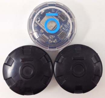
New development of low power Bluetooth 4 technology, as shown in Figure 3-5, will allow
Bluetooth beacons to operate on a single coin cell battery. The low power consumption feature of
18Bluetooth devices running in discovery mode for the proposed work zone application could
extend the battery life significantly. The smaller package size (similar to the size of a US dollar
coin) will make it even easier to deploy by attaching the Bluetooth beacons on barricades, traffic
cones, or flashers in a work zone.
Figure 3-4 A Bluetooth Beacon Prototype Powered by 3 AA Batteries
Figure 3-5 tōd Smart Beacon using Bluetooth 4.0 Technology
(Image Source: http://www.todhq.com/index.html)
In order to reduce power consumption and avoid coverage overlaps among Bluetooth devices,
the range of the OSB410i Bluetooth antenna (typically 75 to 150 meter) can also be adjusted by
using the AT*AMMP command via the serial port adapter tool to cover a smaller area such as 5
to 10 meter radius.
19[AT*AMMP = Max_output_power, Startup_flag]
Where,
Max_output_power =
255: Use the highest output power supported by the Serial Port Adapter as the
maximum output power (default value).
128 - X: -X dBm (X < 30)
128: 0 dBm
128 + Y: +Y dBm (Y < 30)
Startup_flag =
0: The setting will only be valid for the current power cycle.
1: The ConnectBlue Serial Port Adapter will remember the setting between
power cycles. The settings database in the Serial Port Adapter will be
updated.
dBm is power ratio in decibels (dB) of the measured power referenced to one
milliwatt (mW).
For example, a value of Max_output_power = 130 means +2 dBm.
The prototype Bluetooth devices were configured to a few meters of range using [AT*AMMP =
120, 1]. See Appendix C for more information about the ConnectBlue programming interface
using Bluetooth serial port adapter toolbox.
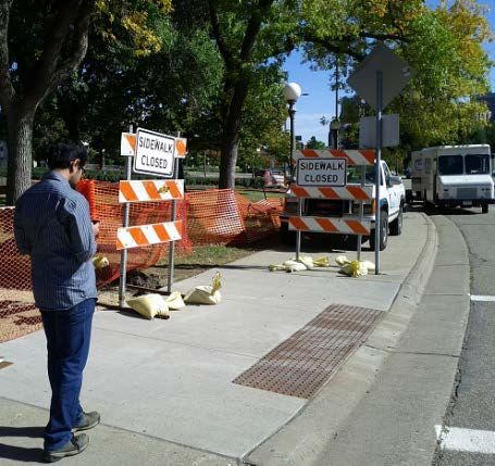
204. SYSTEM TESTING AND VALIDATION
The research team previously performed functional test of the developed smartphone app on the
University of Minnesota east bank campus. Validation of the developed smartphone app at two
construction sites on Martin Luther King Boulevard near the state capitol mall were performed
and discussed in this report. The validation results confirmed that the smartphone app
successfully detects Bluetooth beacons installed about 15 feet away. The smartphone vibrates for
about 1 second and announces the corresponding audible message to a test subject as the person
is approaching an intersection of crosswalk and sidewalk. The subject was able to validate the
audible messages and follow each audible message to bypass the work zone construction.
4.1 Functionality Testing
Functionality testing of the smartphone app was previously performed by placing 4 traffic cones
with Bluetooth beacons attached to each traffic cone on University of Minnesota (UMN) east
bank campus as shown in Figure 4-1. A research student carries the smartphone with the
developed app installed and walks around the test site to validate the TTS interface, Bluetooth
communication range, and other functionalities designed by the research team.
Figure 4-1 Testing locations on UMN campus
(Background Image from Google Inc.)
214.2 System Validation
The repeatability of the Bluetooth communication range was tested and system validation at two
sidewalk closure sites was performed and presented as follows.
4.2.1 Testing of Bluetooth Communication Range
A Bluetooth module operating in a receiving mode was programmed and installed at corners of
an intersection to serve as a geo-reference tag which can be detected by the work zone
smartphone app to identify a user’s location. When operating in the receiving mode, the
Bluetooth module consumes minimal power ranging from 15 to 50 milliwatts (mW). The
Bluetooth module can be either connected to the battery of a barricade flasher or operated using a
very small solar panel. Currently, the Bluetooth beacon prototypes were powered by 3 AA
batteries. A prototype and its enclosure are displayed in Figure 4-2.
Figure 4-2 Bluetooth Beacon Prototype and Enclosure
In order to reduce power consumption and avoid coverage overlaps among Bluetooth beacons,
the antenna range of the OBS410i Bluetooth module (typically 75 to 150 meter) was
programmed (AT*AMMP = 100, see Appendix A for details on AT*AMMP command) to cover
a smaller area such as 5 meter radius.
Figure 4-3 illustrates the configuration for testing the Bluetooth beacon in four different
directions. Table 4-1 listed the results of testing the Bluetooth communication ranges when the
smartphone detects the Bluetooth beacon. The average communication distance when
approaching the Bluetooth beacon from the left direction is 4.9 feet with standard deviation of
1.8 feet. The average communication distance when approaching the Bluetooth beacon from
right direction is 8.7 feet with standard deviation of 5.5 feet. The average communication
distance in front of the Bluetooth beacon is 8.7 feet with standard deviation of 3.3 feet. The
average communication distance in the rear direction of the Bluetooth beacon is 13.1 feet with
standard deviation of 6.3 feet.
22You can also read