DEVELOPMENT OF DYNAMIC MAP FOR AUTOMATED DRIVING AND ITS POTENTIAL TO BE NEXT-GEN INDUSTRIAL INFRASTRUCTURE
←
→
Page content transcription
If your browser does not render page correctly, please read the page content below
Mitsui & Co. Global Strategic Studies Institute Monthly Report July 2018
DEVELOPMENT OF DYNAMIC MAP FOR AUTOMATED DRIVING
AND ITS POTENTIAL TO BE NEXT-GEN INDUSTRIAL INFRASTRUCTURE
Koji Wariishi and Hideki Kinjo
Digital Innovation Dept., Technology & Innovation Studies Div.
Mitsui & Co. Global Strategic Studies Institute
INTRODUCTION
The development of self-driving cars has accelerated in recent years, and fully automated vehicles (i.e., SAE
Levels of Automation 4 or above) will be on the road in around 2020 at the earliest. The largest challenge is to
guarantee the safety of such vehicles. To achieve high level of safety, not only advanced on-board sensors and
AI technology, but also maps for an accurate vehicle localization and predictive driving, are essential. In Japan,
a project is underway to create a dynamic mapping system that combines high-definition three-dimensional (3D)
map data with real-time traffic information (“Dynamic Map”). This report overviews the current development
status of the Dynamic Map and its future outlook.
WHAT IS DYNAMIC MAP?
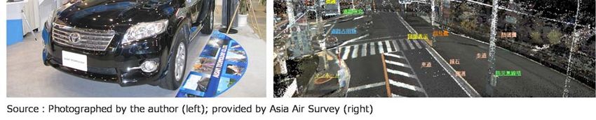
The Dynamic Map is a database that incorporates real-time vehicle/traffic information into high-precision 3D
maps. It is a digital twin or a digital representation of roads and other structures in urban areas. As shown in
Fig. 1, the Dynamic Map integrates four layers of information: (1) static information, or 3D maps including
information on roads, lanes, and location of buildings; (2) semi-static information such as planned traffic
regulations and road works, as well as wide-area weather forecasts; (3) semi-dynamic information such as
accidents, congestions, traffic regulations, and local weather; and (4) dynamic information, which is real-time
information on nearby vehicles, pedestrians, and traffic signals, etc. As for the frequency of updating information,
(1) is updated at least once a month; (2) at least once an hour; (3) at least once a minute; and (4) real time (at
least once a second).
The first layer of the Dynamic Map (statistic information) is a high-definition 3D map database, which is created
by using 3D measurement equipment called the Mobile Mapping System (MMS). The second and third layers,
semi-static and semi-dynamic information, are obtained from outside the vehicle. They include traffic information
1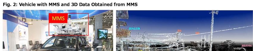
Mitsui & Co. Global Strategic Studies Institute Monthly Report July 2018

provided by road traffic control authorities, weather information, and probe information1. Meanwhile, the fourth
layer, dynamic information, consists of two different types of information: (1) information on surroundings, which
is collected directly by the vehicle via on-board sensors (cameras, radars) and (2) information on the road ahead
from the Intelligent Transport Systems (ITS)2, including nearby vehicles and pedestrians. The latter is obtained
via vehicle-to-vehicle communications, vehicle-to-infrastructure communications, and 5G (fifth-generation
mobile communication) systems, which are expected to increase going forward.

MMS Enables Production of High-Precision 3D Maps

The Mobile Mapping System (MMS) is a measurement equipment system consisting of 3D measurement
equipment such as cameras and laser scanners, and satellite positioning systems (GPS antennas, etc.)
mounted on a vehicle. The vehicle with the MMS can efficiently acquire 3D positioning data on roads (road
shape, etc.) and lanes, as well as traffic signs and other roadside structures (Fig. 2).

In automated driving, it is very important to obtain 3D data on the surrounding environment, as information on
height is necessary to distinguish between the elevated expressway and the general road underneath or identify
interchanges.

WHY DYNAMIC MAP IS NEEDED

In automated driving, a sequence of actions (i.e., recognition, judgment, and operation) are performed by the
automated driving system instead of a human driver. As shown in Fig. 3, the system needs to understand the
vehicle’s location and the driving environment accurately (recognition), make appropriate driving plans including
routes and speed (judgment), and control the vehicle properly (operation).

For safe automated driving, the precise location of a vehicle and accurate information about its surroundings
are essential. In the actual driving environment, however, it is sometimes difficult to get such information. For
example, in satellite positioning systems like GPS, an error of several meters may occur, and signals from a
satellite may be weak in tunnels. In addition, on-board sensors such as cameras and radars may not work
properly due to bad weather, and there are some intersections with poor visibility, leaving blind angles for
sensors.

1   Probe information is information collected from travelling vehicles, such as location and speed data.

2Information on the road ahead from the Intelligent Transport Systems (ITS) is used to predict the
movement of nearby vehicles in the near future.

                                                                                                                2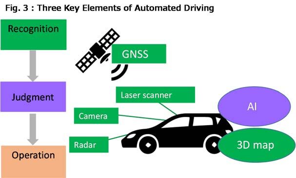
Mitsui & Co. Global Strategic Studies Institute Monthly Report July 2018

                                                                      By combining high-definition 3D maps with
                                                                      data obtained from satellite positioning
                                                                      systems and on-board sensors, a self-
                                                                      driving car can grasp its positioning and
                                                                      surroundings more accurately. It can also
                                                                      secure high safety as it can predict the
                                                                      movement of nearby vehicles based on the
                                                                      dynamic information of the Dynamic Map
                                                                      and make up for blind angles of on-board
                                                                      sensors at intersections with poor visibility.

                                                                      Partially-automated cars (SAE Level 2)
                                                                      with advanced driver assistance systems,
which are widely used at present, monitor the driving environment by themselves via on-board sensors.
Meanwhile, conditionally-automated (Level 3) and highly or fully-automated (Level 4 or above) vehicles need to
coordinate with various infrastructures outside the vehicle, which support self-driving systems, in order to ensure
safety.

Against this backdrop, the Dynamic Map is being developed and expected to be an important infrastructure for
automated vehicles.

CURRENT DEVELOPMENT STATUS OF DYNAMIC MAPPING SYSTEMS

Recent Developments in Japan (1): Public-Private Initiative to Develop Dynamic Map

In Japan, the automated driving system is one of the research and development projects under the Cross-
Ministerial Strategic Innovation Promotion Program (SIP) led by the Cabinet Office. This project (SIP-adus) is
aimed at (1) reducing accidents and congestions in road traffic, (2) early implementation and wider use of
automated driving, and (3) deployment of a next-generation urban transportation system.

In SIP-adus, there are five key technology fields in which all relevant parties collaborate: (1) the Dynamic Map;
(2) cyber security; (3) Human Factors; (4) pedestrian traffic accident reduction; and (5) the next-generation
transport. As such, the development of the Dynamic Map is positioned as an important theme in SIP-adus.

The high-definition 3D maps in the Dynamic Map were prepared for 14,000km of main expressways in Japan
in FY2017 and those covering 30,000km of expressways nationwide (total of both ways) are to be completed
by the end of FY2018. Of note, a large-scale field operational test for the automated driving system started in
October 2017, in which trial data of the Dynamic Map is used under real traffic conditions. The near-term goal
of the project is to realize Level 3 automation on highways in 2020. Toward this goal, the specifications and
accuracy of the high-definition map data, data updating/delivering systems, as well as links between the 3D
map and dynamic information obtained from outside the vehicle, are being verified in the test. The next target
is to establish technology necessary for Level 3 automation on general roads and Level 4 automation (fully-
automated driving) on highways by 2023, and to put it into practice in 2025.

Recent Developments in Japan (2): Efforts to Commercialize Dynamic Map Started in Private Sector

While the public and private sectors work together to develop the Dynamic Map in SIP-adus, efforts for the
commercialization of the dynamic mapping system are also being made.

With the aim of developing and operating a dynamic mapping system, several automakers and mapping
companies jointly invested in and established Dynamic Map Planning as a planning company in June 2016,
which conducted a feasibility study on the Dynamic Map. The company was then changed to an operating
company and renamed itself to Dynamic Map Platform in June 2017, making a new start to develop and operate
the Dynamic Map with united efforts. The current major shareholders include Innovation Network Corporation

                                                                                                                  3
Mitsui & Co. Global Strategic Studies Institute Monthly Report July 2018
of Japan, Mitsubishi Electric Corporation, Zenrin, Pasco, Aisan Technology, Increment P (a subsidiary of
Pioneer), Toyota Mapmaster, and ten Japanese automakers.
One of the challenges for putting the Dynamic Map into practical use is how to develop and maintain high-
definition 3D map data for all the roads in Japan (1,200,000km). Dynamic Map Platform plans to decide policies
for developing maps for general roads by 2021. It also aims to reduce costs by developing automated map
updating technology.
Developments Overseas: Creation of 3D Maps Led by Major Mapping Companies
In Europe, the European Commission has spearheaded initiatives to realize the Cooperative, Connected, and
Automated Mobility (CCAM). Each member country has also launched its own unique projects. In the US,
Department of Transportation released new federal guidance for automated driving systems “A Vision for Safety
2.0” in September 2017, and each state is developing a policy framework associated with autonomous driving.
Against this backdrop, major mapping companies are accelerating their moves to develop high-definition 3D
map data. We will take a brief look at the following three leading players: (1) HERE Technologies (Netherlands);
(2) TomTom (Netherlands); and (3) Waymo (US).
(1) HERE Technologies
HERE Technologies, a major mapping company in Europe, is developing HD Live Maps, highly accurate map
data for automated driving. The maps have already covered 555,000km of roads and are to cover more than
1,000,000km by the end of 2018. HD Live Maps automatically update map data by using data measured by on-
board sensors, leading to lower updating costs.
The company’s major shareholders include German car manufacturers Daimler, BMW, and Audi. It also
received investments from Intel (US), Tencent (China), NavInfo (China), and GIC (Singapore) in 2017, and
Bosch (German) and Continental (Germany) in January 2018. As for relationships with Japanese companies,
HERE Technologies announced capital alliance with Pioneer, and also agreed to collaborate with Dynamic Map
Platform. In May 2018, the company joined forces with Increment P, NavInfo, and SK Telecom (South Korea)
to create OneMap Alliance, and plans to provide map data in 2020. As such, it seems to be a leading provider
of 3D map data for autonomous driving.
(2) TomTom
TomTom, another major mapping company in Europe, is also developing 3D maps for automated driving. Its
RoadDNA technology converts 3D data into 2D data, with the distance to an object shown by colors, which
reduces costs for processing frequently changing data. The company has created 3D map data for 380,000km
of major roads in the US and Europe, and 18,000km of highways in Japan. In January 2018, it announced a
deal with Chinese internet company Baidu to collaborate on 3D maps. It has also partnered with Japanese
mapping company Zenrin.
(3) Waymo
Alphabet’s self-driving unit Waymo is using 3D maps developed in-house. It apparently keeps ahead of the pack
in developing automated vehicles, and announced collaboration with Fiat Chrysler Automobiles (Netherlands)
and Honda Motor (Japan). While it is still unclear whether Fiat and Honda will use Waymo’s 3D maps, the
company may take a similar strategy to Google Map’s by giving free access to the map.
International Coordination
Given such active efforts made by major mapping companies abroad, Japan’s public and private sectors started
to cooperate with relevant overseas organizations toward the global harmonization of dynamic mapping
systems. Japan is promoting activities to standardize dynamic mapping systems, by making a proposal of
specifications to the International Organization for Standardization (ISO). In addition, SIP-adus has participated
4Mitsui & Co. Global Strategic Studies Institute Monthly Report July 2018
in the industry’s standardization initiative Open AutoDrive Forum, led by European and American players, and
has promoted collaborations with the Navigation Data Standard (NDS), an European consortium for developing
a standardized format for driving-grade navigation systems. As such, efforts are being made to establish de-
facto standards.
FUTURE OUTLOOK: DYNAMIC MAP HAS POTENTIAL TO BE NEXT-GENERATAION
INDUSTRIAL INFRASTRUCTURE
The Dynamic Map is a new infrastructure with geospatial information. Real-time information can be compiled
on the 3D map (a replica of the physical town in cyberspace), and new information added by the users gives
rise to the value and usefulness of the Map. A digital twin of the city including various information can be created
based on the Dynamic Map.
As such, the Dynamic Map can be used for other purposes than automated driving. Possible applications that
have been discussed are as follows.
Personal Navigation
In personal navigation, the Dynamic Map can be used to provide value-added navigation services for users of
small-size personal mobility device or for mobility-vulnerable people, by adding information about a pedestrian
network including height and width of sidewalks. One example is to show a barrier-free route, which is easy for
parents with children in strollers to walk through, and place an advertisement for products targeting children on
the route.
Logistics
In logistics, information about the entrance of a building, such as height limits and loading/unloading areas, can
be added to the Dynamic Map in order to support safe and efficient logistics involving large trucks, etc. Moreover,
navigation services for drone logistics, which are expected to increase going forward, can be provided by adding
restricted airspace information.
Real Estate and Urban Development
In real estate and urban development, information on building structures, traffic volume, and pedestrians can
be added to the Dynamic Map, which enables a more accurate simulation of the damage which would likely be
caused by a natural disaster. Based on such simulation, more specific measures can be taken to reduce the
number of casualties caused by such damage, by deciding escape routes or areas for evacuation.
Going forward, the applications and functions of the Dynamic Map will be further enhanced. The value of the
Map is expected to increase, as it serves as a shared infrastructure to connect/coordinate such applications.
(Fig. 4)
5Mitsui & Co. Global Strategic Studies Institute Monthly Report July 2018
Fig. 4︓Enhanced Applications of Dynamic Map
Logistics
Real estate/
Personal navigation
Entrance urban development
info.
Advertise Life style
ment Traffic info.
info.
Store Weather
information
Buildings/landmarks info.
Buildings/landmarks Road Landmarks/emergency exits
shapes
Sidewalks Land
/indoors features
Dynamic Mapʼs Common Infrastructure
(Data sharing/coordination, Interoperability)
Autonomous driving New area
Nearby
New area
vehicles/ Info. E
pedestrians
Info. A
Congestion Info. F
Info. B
Traffic regulations Info. G
Info. C
Road
Info. H
shapes
Info. D
The Dynamic Map has the potential to become an information infrastructure to realize the Society5.0 (Super
Smart society) advocated by the Japanese government. We expect it to serve as an infrastructure to integrate
data from various sources in different applications (i.e., automated driving and other areas), and to evolve into
the next-generation industrial infrastructure, which helps create new business.
--------------------------------------------------------------------------------------------------------------------------------------------------------------------------------------
Any use, reproduction, copying or redistribution of this report, in whole or in part, is prohibited without the prior consent of Mitsui & Co.
Global Strategic Studies Institute (MGSSI). This report was created based on information and data obtained from sources believed to be
reliable; however, MGSSI does not guarantee the accuracy, reliability, or completeness of such information or data. Opinions contained in
this report represent those of the author and cannot in any way be considered as representing the unified opinion of MGSSI and the Mitsui
& Co. group. MGSSI and the Mitsui & Co. group will not be liable for any damages or losses, whether direct or indirect, that may result
from the use of this report. The information in this report is subject to change without prior notice.
6You can also read