Development on Indigenous Homelands and the Need to Get Back to Basics with Scoping: Is There Still "Unceded" Land in Northern Ontario, Canada ...
←
→
Page content transcription
If your browser does not render page correctly, please read the page content below
The International Indigenous Policy Journal
 Volume 12 | Issue 1

 March 2021

Development on Indigenous Homelands and
the Need to Get Back to Basics with Scoping:
Is There Still “Unceded” Land in Northern
Ontario, Canada, with Respect to Treaty No. 9
and its Adhesions?

 Leonard Tsuji
 University of Toronto, Canada, leonard.tsuji@utoronto.ca

 Stephen Tsuji
 University of Waterloo, Canada, srjtsuji@uwaterloo.ca

Recommended Citation
Tsuji, L., & Tsuji S. (2021). Development on Indigenous Homelands and the need to get back to basics with scoping: Is there
still “unceded” land in Northern Ontario, Canada, with respect to Treaty No. 9 and its Adhesions? The International Indigenous
Policy Journal, 12(1). https://doi.org/10.18584/iipj.2021.12.1.8551
Development on Indigenous Homelands and the Need to Get Back
to Basics with Scoping: Is There Still “Unceded” Land in Northern
Ontario, Canada, with Respect to Treaty No. 9 and its Adhesions?

Abstract
Scoping includes the establishment of unambiguous spatial boundaries for a proposed development initiative (e.g.,
a treaty) and is especially important with respect to development on Indigenous homelands. Improper scoping
leads to a flawed product, such as a flawed treaty or environmental impact assessment, by excluding stakeholders
from the process. A comprehensive literature search was conducted to gather (and collate) printed and online
material in relation to Treaty No. 9 and its Adhesions, as well as the Line-AB. We searched academic databases as
well as the Library and Archives Canada. The examination of Treaty No. 9 and its Adhesions revealed that there is
unceded land in each of four separate scenarios, which are related to the Line-AB and/or emergent land in
Northern Ontario, Canada. Lastly, we present lessons learned from our case study. However, since each
development initiative and each Indigenous Nation is unique, these suggestions should be taken as a bare minimum
or starting point for the scoping process in relation to development projects on Indigenous homelands.

Keywords
Indigenous homelands, development, scoping, environmental assessment, Treaty No. 9, Treaty No. 9 Adhesions,
Northern Ontario, Canada, Line-AB, unceded land

Acknowledgments
We thank the Social Sciences and Humanities Research Council of Canada for funding support.

Creative Commons License

This work is licensed under a Creative Commons Attribution-Noncommercial-No Derivative Works 4.0
License.
1
                                         Tsuji & Tsuji: Development on Indigenous Homelands

     Development on Indigenous Homelands and the Need to Get Back to Basics with Scoping:
                  Is There Still “Unceded” Land in Northern Ontario, Canada,
                        With Respect to Treaty No. 9 and its Adhesions?

Development projects are increasingly affecting Indigenous homelands in northern Canada and around
the world (Tsuji et al., 2011). Kirchhoff et al. (2013) explained that in development projects:

          Environmental challenges occur frequently. Approaches to mitigate damage, to halt
          developments and undertakings that are likely to cause serious problems and, in some cases, to
          compare alternatives and identify the most desirable options have been developed. One of the
          main ways of doing this is through environmental [impact] assessment (EA) processes of
          various types. The most entrenched form of environmental assessment is project-level
          environmental assessment, which is now common in virtually every part of the world. (p. 2)

Proper scoping is an essential part of the environmental assessment process (Whitelaw et al., 2009).
Similarly, proper scoping should have been historically—and should be at present—an essential part of
the treaty-making (or negotiated agreement-making) process. Although a universally held definition for
the term scoping does not exist (Mulvill & Baker, 2001), a common element of the scoping process is
“the establishment of unambiguous spatial boundaries for the proposed project” (Tsuji et al., 2011,
p. 37). Scoping is a term generally used in environmental assessment literature with respect to
development projects and should become more common in the treaty-making literature because both
processes often have development on Indigenous homelands as the end goal. As stated by Tsuji et al.
(2011):

          Proper scoping is essential for any environmental assessment (EA) process. This is particularly
          true with respect to resource development in the intercultural setting of First Nation homelands
          of northern Canada. (p. 37)

Improper scoping in either the environmental assessment process or treaty-making process leads to a
flawed product—that is, a flawed environmental assessment or treaty—by excluding Indigenous people
who should be included in the process and/or including people who should not be included. For
example, the Victor Diamond Mine environmental assessment process in Northern Ontario, Canada,
excluded Indigenous groups through the establishment of erroneous spatial boundaries for the project
(Tsuji et al., 2011; Whitelaw et al., 2009, 2012). Unrest in the communities and winter-road blockades
followed (Whitelaw et al., 2009). The diamond mine’s scoping process was:

          Based on two erroneous assumptions: that the registered trapline system [of the Government of
          Ontario] was the accepted system of land use/occupation in northern Ontario, and that land
          use/occupancy was based on the treaty-imposed reserve system (not the family-based
          traditional lands system). (Tsuji et al., 2011, p. 37)

Similarly, Long (2010) noted, in treaty-making “Indigenous territories seldom conform to the
boundaries of the state” (p. 64). This is true in Canada and worldwide where there are treaties with
Indigenous people. For example, in the United States of America (US), the American Indians in
Northern California were never properly enumerated, and their Traditional Lands never properly
demarcated before the signing of the treaties—and for political reasons, the Californian Indian Treaties

Published by Scholarship@Western, 2021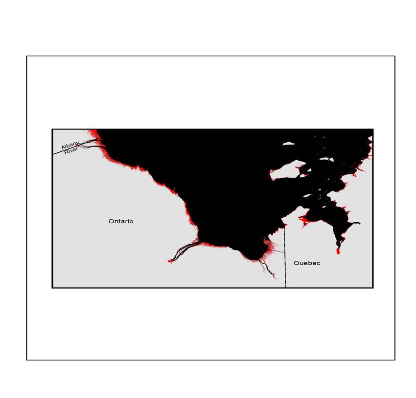
2
The International Indigenous Policy Journal, Vol. 12, Iss. 1
were never ratified—thus, successive US governments were left to deal with treaty issues not of their
own making (Miller, 2013). In another case, the “redrawing” of treaty boundaries in the Fort Laramie
Treaty of 1868 has led to an ongoing legal battle between the US and the Sioux Nation (Cutlip, 2018).
Thus, treaty boundaries—like development project boundaries—must be properly scoped and
validated, or there will be unforeseen consequences.
Our case-based development-and-scoping study centres on Treaty No. 9 and its Adhesions:
Unfortunately, there is simply no consensus about what Treaty Nine represents. Simple facts
like the admissions of Indians north of the Albany River in 1905 and the arbitrary line,
designated AB [hereafter referred to as the line-AB] . . . have been ignored by historians. (Long,
1989, p. 41)
In 1867, when Ontario, Quebec, New Brunswick, and Nova Scotia were amalgamated to form the
Dominion of Canada, this confederation of provinces (Figure 1) did not resemble what we today
consider the country of Canada1 (Figure 2). The provinces of Ontario and Quebec were only a portion
of their current size; most of present-day Canada’s land mass was embodied in Rupert’s Land and the
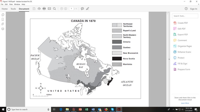
North-Western Territory. In 1870, an Order of Her Majesty (Queen of England) in Council admitted
Rupert’s Land and the North-Western Territory into the Dominion of Canada (Rupert’s Land and
North-Western Territory—Enactment No. 3, 1870). Together, Rupert’s Land and the North-Western
Territory were renamed the Northwest Territories (Figure 3). The lands of the Northwest Territories
would be partitioned to become the provinces and territories of the country of Canada (Figure 2).
However, in the Rupert’s Land and North-Western Territory—Enactment No. 3 (1870), it was stated in
the terms and conditions:
Any claims of Indians to compensation for lands required for purposes of settlement shall be
disposed of by the Canadian Government in communication with the Imperial [British]
Government; and the [Hudson’s Bay] Company shall be relieved of all responsibility in respect
of them. (Part 1, Section 14)
1
A federated system of government exists in Canada; whereby, there are two levels of government: the central or federal
government (originally known as the Dominion of Canada, now referred to as the Government of Canada), and the
provincial (e.g., Government of Ontario) and territorial (e.g., Government of Nunavut) governments. Areas of legislative
power were first specified for the different levels of government in the British North American Act (1867; now known as the
Constitution Act, 1867) and then later in the repatriated Constitution Act (1982). According to the British North American
Act (1867), the Government of Canada has legislative authority over “Indians, and Lands reserved for the Indians”
(VI. Distribution of Legislative Powers, Section 91, Item 24).
DOI:10.18584/iipj.2021.12.1.85513
Tsuji & Tsuji: Development on Indigenous Homelands
Figure 1. Canada in 1867
Note. Adapted from “Post-Glacial Isostatic Adjustment and Global Warming in Subarctic Canada: Implications for Islands of
the James Bay Region,” by L.J.S. Tsuji, N. Gomez, J.X. Mitrovica, and R. Kendall, 2009, Arctic, 62(4), p. 460
(https://doi.org/10.14430/arctic176). Copyright 2009 by Arctic Institute of North America.
Figure 2. Canada in 1997
Note. Adapted from “Akimiski Island, Nunavut, Canada: A Test of Inuit Title,” by C. Pritchard, B. Sistili, Z. General, G.S.
Whitelaw, D.D. McCarthy, and L.J.S. Tsuji, 2010, Canadian Journal of Native Studies, 31(2), p. 411
(http://www3.brandonu.ca/cjns/30.2/09tsuji.pdf). Copyright 2010 by the University of Brandon.
Published by Scholarship@Western, 20214
The International Indigenous Policy Journal, Vol. 12, Iss. 1
Figure 3. Canada in 1870
Note. Adapted from “Territorial Evolution,” by Natural Resources Canada, n.d. (https://www.nrcan.gc.ca/earth-
sciences/geography/atlas-canada/selected-thematic-maps/16884). Copyright n.d. by Natural Resources Canada.
Schedule A of the Order-in-Council2 offers further elaboration of this point:
Upon the transference of the territories in question to the Canadian Government, the claims of
the Indian tribes to compensation for lands required for purposes of settlement will be
considered and settled in conformity with the equitable principles which have uniformly
governed the British Crown in its dealings with the aborigines. (Cauchon & Cockburn, 1867,
para. 11)
In other words, Indian3 lands could only be acquired by consent (ceded or purchased) as the British
Crown believed that Indigenous people held rights to land in North America (Henry, 2006; The Royal
Proclamation of 1763). Thus, the period from1870 to1930 was characterized by the signing of 11
treaties (and their adhesions) between the Government of Canada and various First Nations that
2
“A federal Order-in-Council is a legal instrument made by the Governor in Council pursuant to a statutory authority or, less
frequently, the royal prerogative. All orders in council are made on the recommendation of the responsible Minister of the
Crown and take legal effect only when signed by the Governor General [of Canada]. Orders-in-Council address a wide range
of administrative and legislative matters . . . [for example] the disposition of Indigenous lands” (Library and Archives Canada,
2020, About Orders-in-Council section, para. 2). Similarly, for the Government of Ontario, “An Order in Council is a legal
order made by the Lieutenant Governor, on the advice of the Premier [of the Province of Ontario] or a Minister [of the
Government of Ontario]” (Government of Ontario, 2020, para. 1).
3
The term “Indian” was erroneously used to describe Indigenous people in North America because European explorers
thought they had landed in India. We use the term “Indian” throughout this article when referencing historical documents.
Otherwise, we use the term First Nations. Further, although the Canadian Constitution Act (1982) states, “In this Act,
‘aboriginal peoples of Canada’ [emphasis added] includes the Indian, Inuit and Métis peoples of Canada” (Section 35(2)).
We use Indigenous Peoples in keeping with recent developments in Canada.
DOI:10.18584/iipj.2021.12.1.85515
Tsuji & Tsuji: Development on Indigenous Homelands
became known as the Numbered Treaties (Indigenous and Northern Affairs Canada, 2016; Figure 4).
These treaties were necessary to allow for relatively unfettered development on Indigenous Lands.
Unique among the Numbered Treaties was Treaty No. 9 with the Cree, Ojibwe, and Oji-Cree peoples,
as it was the first and only Numbered Treaty where one member of the Treaty Commission was
nominated by and represented a province (Ontario), along with the usual Canadian government
representatives4 (Scott et al., 1905). Perhaps this is the reason why so much controversy and confusion
has been associated with Treaty No. 9 and its Adhesions, and, as we will illustrate, why areas of Northern
Ontario were not included in Treaty No. 9 and its Adhesion.
Figure 4. Numbered Treaties
Note. Adapted from the “Historical Treaties of Canada” map, by Indian and Northern Affairs Canada, n.d.c.
(https://www.aadnc-aandc.gc.ca/DAM/DAM-INTER-HQ/STAGING/texte-text/htoc_1100100032308_eng.pdf).
Copyright n.d. by Indian and Northern Affairs Canada.
The present article will be the first to examine specifically the question of whether there is still unceded
land in Northern Ontario related to Treaty No. 9, its Adhesions, and the Line-AB, in the context of
proper scoping. The article begins with a very brief background section about Treaty No. 9 to set the
stage of the present study. A description of the methods employed will then be presented. This section is
followed by results, discussion based on secondary data analyses relevant to the research question, and
the conclusions of the study including lessons learned with respect to scoping.
4
Note that in Treaty No. 8, the Province of British Columbia participated, but had a very limited role in the treaty-making
process (Long, 2010).
Published by Scholarship@Western, 20216
The International Indigenous Policy Journal, Vol. 12, Iss. 1
Background
The Treaty-Making Process in Northern Ontario
In 1905, a Treaty No. 9 field team was assembled with commissioners appointed by both the
Government of Ontario (Daniel G. MacMartin) and the Government of Canada (Duncan C. Scott and
Samuel Stewart); this Treaty No. 9 Commission was entrusted with the task of travelling down the
Albany River and stopping at Hudson’s Bay Company fur-trading posts to enter into treaty with First
Nations living in the area south of the Albany River (Scott et al., 1905). The Albany River was the
northern boundary of Ontario as defined by law at that time.5 As emphasized by the Treaty No. 9
commissioners in their report:
Under the provisions of clause 6 [the Statute of Canada, 54-55 Vic., chapter V] . . . the terms of
the treaty [No. 9] were fixed by the governments of the Dominion and Ontario [emphasis
added]; the commissioners were empowered to offer certain conditions, but were not allowed to
alter or add to them in the event of their not being acceptable to the Indians. (Scott et al., 1905,
p. 2)
This is why many Treaty No. 9 researchers have suggested that there were no negotiations with First
Nations, as the commissioners could not change the terms of the treaty (e.g., Dragland, 1994; Long,
1989, 2010; Morrison, 1986, 1988). Thus, when the commissioners’ train departed Ottawa for
Dinorwic, a small Canadian Pacific Railway station in Ontario6 (Dragland, 1994; Long, 2006; Scott,
1947), on June 30, 1905, to start their Treaty No. 9 field expedition, the commissioners were not
authorized to change the specific terms of Treaty No. 9 (Scott et al., 1905). However, the
commissioners in their Treaty No. 9 report also stated:
As the cession of the Indian title in that portion of the Northwest Territories which lies to the
north of the Albany river would have to be consummated at no very distant date, it was thought
advisable to make the negotiations with Indians whose hunting grounds were in Ontario serve as
the occasion for dealing upon the same terms with all the Indians trading at Albany river posts,
and to add to the community of interest which for trade purposes exists amongst these Indians a
like responsibility for treaty obligations. We were, therefore, given power by Order of His
Excellency in Council of July 6, 1905, to admit to treaty any Indian whose hunting grounds
cover portions of the Northwest Territories lying between the Albany river, the district of
Keewatin and Hudson Bay [emphasis added], and to set aside reserves in that territory. (Scott et
al., 1905, p. 1)
The timing of the Order-in-Council (Government of Canada) is important, as the authority to admit
First Nations whose land was north of the Albany River to Treaty No. 9 was provided after the Treaty
No. 9 commissioners were in the field.
5
In 1889, “the federal government awarded the Kenora area to Ontario in 1889. At the same time, the Albany River became
the province’s northern boundary” (Ontario Ministry of Government and Consumer Services, n.d., Ontario Boundaries 1889
section, para. 1).
6
Dinorwic also served at a Hudson’s Bay trading post located near Dryden and Sioux Lookout, Ontario, and 200 miles east of
Winnipeg, Manitoba (Dragland, 1994; Long, 2006; Scott, 1947).
DOI:10.18584/iipj.2021.12.1.85517
Tsuji & Tsuji: Development on Indigenous Homelands
Moreover, the Treaty No. 9 official text makes no mention of the land north of the Albany River:
The said Indians [Cree, Ojibwe, and Oji-Cree peoples] do hereby cede, release, surrender and
yield up [emphasis added] to the government of the Dominion of Canada, for His Majesty the
King and His successors forever, all their rights titles and privileges whatsoever, to the lands
included within the following limits, that is to say: That portion or tract of land lying and being
in the province of Ontario [emphasis added], bounded on the south by the Height of Land and
the northern boundaries of the territory ceded by the Robinson-Superior Treaty of 1850, and
the Robinson-Huron Treaty of 1850, and bounded on the East and North by the boundaries of
the said Province of Ontario as defined by law [emphasis added], and on the West by a part of
the eastern boundary of the territory ceded by the Northwest Angle Treaty No. 3; the said land
containing an area of ninety thousand square miles, more or less [emphasis added]. (Treaty No.
9, 1905, p. 1)
Further, according to maps found on the Government of Canada website for treaties (Crown–
Indigenous Relations and Northern Affairs Canada, 2020), it is clear that the northern boundary of
Treaty No. 9—as per the written text of the Treaty—was the Albany River, which at the time was the
northern boundary of Ontario (see Figure 4 & Figure 5) as defined by law (Indian and Northern Affairs
Canada, n.d.b).
Thus, it is difficult to comprehend how the Treaty No. 9 commissioners can state the following in their
official Treaty No. 9 report:
Cession was taken of the tract described in the treaty, comprising about 90,000 square miles,
and, in addition, by the adhesion of certain Indians whose hunting grounds lie in a northerly
direction from the Albany river, which may be roughly described as territory lying between that
river and a line drawn from the northeast angle of Treaty No. 3, along the height of land
separating the waters which flow into Hudson bay by the Severn and Winisk from those which
flow into James bay by the Albany and Attawapiskat [emphasis added; this northern boundary
will be later referred to as the Line-AB by the Treaty No. 9 Adhesion Commissioners, Cain &
Awrey (1929); Figure 6], comprising about 40,000 square miles [emphasis added]. (Scott et al.,
1905, p. 8)
Since, there is no mention of the Line-AB in the text of Treaty No. 9—even though the Treaty No. 9
commissioners retrospectively asserted that the Line-AB was the northern boundary of Treaty No. 9—
that is, the Albany River (Treaty No. 9, 1905). Historically, it should be noted that the Government of
Canada held the position that only the written text in any treaty was binding:
The Government cannot admit their claim to any thing which is not set forth in the treaty [with
specific reference to Treaties 1 and 2] . . . which treaty is binding alike upon the Government
and upon the Indians, yet, as there seems to have been some misunderstanding between the
Indian Commissioner and the Indians in the matter of Treaties Nos. 1 and 2, the Government,
out of good feeling to the Indians and as a matter of benevolence, is willing to raise the annual
payment to each Indian under Treaties Nos. 1 and 2 . . . on the express understanding, however,
that each Chief or other Indian who shall receive such increased annuity or annual payment shall
be held to abandon all claim whatever against the Government in connection with the so-called
Published by Scholarship@Western, 20218
The International Indigenous Policy Journal, Vol. 12, Iss. 1
“outside promises,” other than those contained in the memorandum attached to the treaty.
(Committee of the Honourable Privy Council, 1875, p. 1)
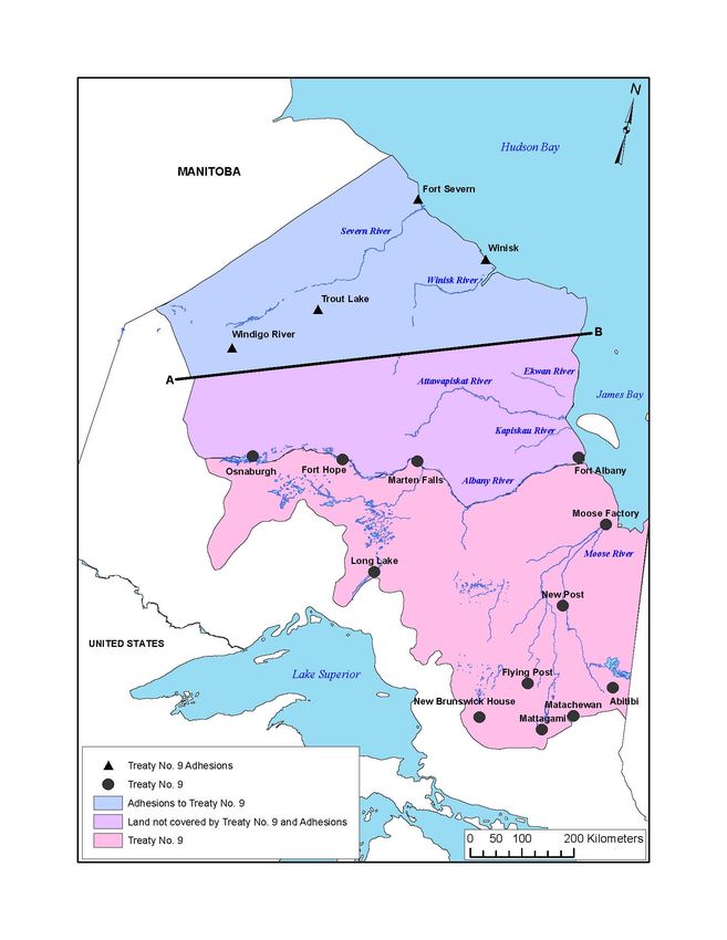
Figure 5. Treaty No. 9 and Adhesions
Note. The small triangular area delineated in the northeast corner of Manitoba and the northwestern corner of Ontario is a
cartographic error based on the original Treaty No. 9 Adhesion map (see Figure 9); this triangular area is now part of the
Province of Manitoba. Adapted from “Historical Treaties of Canada” map, by Indian and Northern Affairs Canada, n.d.c.
(https://www.aadnc-aandc.gc.ca/DAM/DAM-INTER-HQ/STAGING/texte-text/htoc_1100100032308_eng.pdf) and
the “Canada in 1905” map, by Indian and Northern Affairs Canada, n.d.a. (https://www.rcaanc-cirnac.gc.ca/DAM/DAM-
CIRNAC-RCAANC/DAM-TAG/STAGING/texte-text/hc1905trty_1100100028856_eng.pdf). Copyright n.d. by Indian
and Northern Affairs Canada.
DOI:10.18584/iipj.2021.12.1.85519
Tsuji & Tsuji: Development on Indigenous Homelands
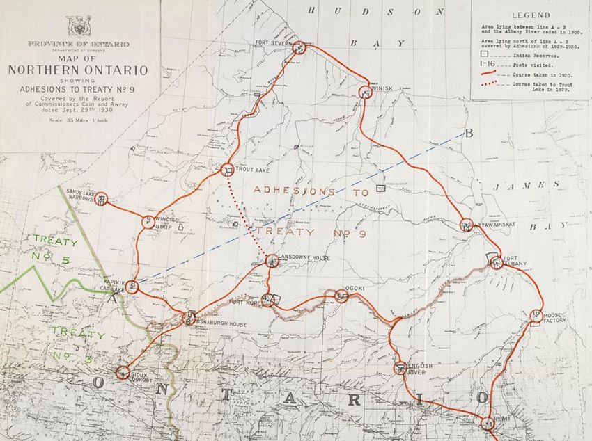
Figure 6. Map Showing Line-AB
Note. From Report of Commissioners re Adhesion to Treaty No. 9, for the year 1930, by W.C. Cain and H.N. Awrey, 1930.
In the public domain.
However, since the Constitution of Canada was repatriated in 1982:7
Canadian courts have ruled that treaties must be interpreted in accordance with the common
intention of treaty partners and that oral promises made during treaty negotiations cannot be
ignored when interpreting treaty texts. (Coyle & Borrows, 2017, p. 8)
An Indigenous Perspective on Land in Northern Ontario
The Government of Ontario and many in Southern Ontario view the province’s Far North as an
untouched hinterland containing vast swaths of natural resources (Gardner et al., 2012). Although it is
true that there are vast resources in the Far North of Ontario, it is far from untouched. This region of the
province appears untouched because the First Nations people of Northern Ontario have treated the land
7
With repatriation of the Constitution of Canada in 1982, the British Crown no longer held legal power to amend the
Constitution of Canada. Moreover, the repatriated Constitution entrenched Indigenous Treaty Rights:
Section 35(1) [Canadian Constitution Act, 1982] recognizes and affirms the treaty rights ‘of the Aboriginal
peoples,’ not the treaty rights of the Crown. In other words, treaty rights of the Aboriginal peoples are
constitutionalized, while the treaty rights of the Crown are not. The Sparrow decision held that because Aboriginal
rights are constitutional, they take priority over other rights which are not constitutional. (Macklem 1997, p. 131)
For other examples, see Regina v. Badger (1996) and Regina v. Sundown (1999). Adding further, “The [Canadian] Court
has signaled that there is more to a treaty than its written text” (Macklem, 1997, p. 100).
Published by Scholarship@Western, 202110
The International Indigenous Policy Journal, Vol. 12, Iss. 1
respectfully and used it sustainably over millennia. As Chief Jonathon Solomon (2009) of Kashechewan
First Nation stated:
We live in the north. The land up north is our home. It’s our lifeline, it’s our bloodline of who we
are. The land up north is not an untouched land. Our people, my ancestors, travelled that land.
All over the area of my land, you can see sacred burial grounds, where my people died, where
they lost their loved ones during the winter months. So it’s not an untouched land; it’s not a land
that has been discovered. We’ve been there for thousands and thousands of years. We were very
nomadic people. We are still closely tied to the land. Like I said, that is our bloodline, our lifeline.
Without land, we will [not] be Cree people of James Bay . . . Where there are footprints all over
the place in my territory, that signifies that my people were out in the land. (p. 954)
Similarly, Band Councillor Sam McKay (2009) of Kitchenuhmaykoosib Inninuwug, also known as Big
Trout Lake First Nation, said:
Our concepts of preserving Mother Nature . . . We are one with the land, we depend on it to feed
our families, and we have thousands of years of intergenerational experience with how to live in
harmony with the land and preserve it, not destroy it in a few years. (p. 912)
Chief George Hunter (2009) of Weenusk First Nation asserted:
The protection of our homelands . . . The Far North is First Nations land . . . the land looks after
us. We have an abundance of fish, wildlife, waterfowl and stuff, and as a result, the land is our
social welfare system, and we would like to keep it that way. We’ve got good, clean water and we
can dip our cups into any of our river and creek systems without worrying . . . We have not
contaminated and harmed our land. (p. 956)
In addition, First Nation leaders of Northern Ontario stress that they did not own the land, but were
stewards of the land:
Man does not own land. (Elder Janet Nakogee of Attawapiskat First Nation recorded in 1987,
cited in Long, 1993, p. 57)
I always believed that the Creator included me in his creation. Therefore, I belonged to the land.
The same goes for everybody. The Natives did not have any problems as [long as] they pursued
their traditional life. (Elder John Matinas of Attawapiskat First Nation recorded in 1987, cited in
Long, 1993, p. 22)
When we’re talking about the land, the people are connected to the land. First Nations people
are stewards of the land; it’s part of us. (Chief Keeter Corston of Chapleau Cree First Nation;
Corston, 2009, p. 955).
Thus, it is understandable in the context of the First Nations worldview that if one does not own the
land, one cannot give up the land by treaty, but one can share the land with others. According to Grand
Chief of Mushkegowuk Council Stan Louttit (2011):
DOI:10.18584/iipj.2021.12.1.855111
Tsuji & Tsuji: Development on Indigenous Homelands
The [Treaty No. 9] Commissioner’s Diaries record many Oral Promises that were made to the
First Nations at Treaty [No. 9] time, which were not recorded in the official written document
[Treaty No. 9]. The Diaries support the Elder’s story that they never gave up their land. (Slide
13)
From a First Nations’ perspective, stewardship of the land is an inherent right bestowed upon them.
Grand Chief Stan Beardy (2009) of Nishnawbe Aski Nation stated:
The north is our homeland and we govern and protect it through our inherent right, given to us
by the Creator. Since time immemorial, our people have exercised our inherent right and
protected the lands. That is why they are still in pristine condition. And we will continue to
protect our lands for future generations. (p. 828)
Chief Andrew Solomon of Fort Albany First Nation (2009) said:
When you talk about jurisdiction, that there are only two ways you can have jurisdiction: You
can inherit it—one way—or you get delegated it. The province [of Ontario] and the feds
[Government of Canada] got delegated by the Queen of England. First Nations here, we
inherited it from our Creator. (p. 954)
Indeed, the Government of Canada is starting to acknowledge Indigenous Inherent Rights beyond what
is contained in the Canadian Constitution Act (1982).
The new policy will recognize Indigenous lawmaking power; their inherent rights to land; and,
in many instances, title within their traditional territories. In all, the legislation and policy will
support the implementation of the new United Nations Declaration on the Rights of Indigenous
Peoples Act. (Crown–Indigenous Relations and Northern Affairs Canada, 2018, para. 4)
Nonetheless, there are some concerns with this emerging Indigenous rights process (for a critical review,
see King & Pasternak, 2018). In addition, the related issues of Aboriginal Title and private property are
complex, which will require the abandoning of absolutes with respect to common law, constitutional
law, and Indigenous law in order to find resolution (Borrows, 2015).
Methods
A comprehensive literature search was conducted to gather (and collate) printed and online material in
relation to Treaty No. 9 and its Adhesions, as well as the Line-AB. Starting in 2007, we searched
academic databases as well as the Library and Archives Canada; online sources were last accessed August
27, 2019. Data sources used in the present study included Treaty No. 9 and its Adhesions, maps,
photographs, reports, correspondence, drafts, memorandums, Order-in-Councils, books, articles,
diaries, published Indigenous oral history, PowerPoint presentations, and the film Trick or Treaty based
on Treaty No. 9 (also known as the James Bay Treaty; Obosawin, 2014). Data were analysed
qualitatively by manual coding, using deductive thematic analysis. We used an organizational template
to guide deductive coding in order to determine if Treaty No. 9 was properly scoped with unambiguous
spatial boundaries (Tsuji et al., 2011). In addition, data were analyzed and categories were created using
Published by Scholarship@Western, 202112
The International Indigenous Policy Journal, Vol. 12, Iss. 1
inductive thematic analysis—that is, categories emerged from the data itself (Fereday & Muir-
Cochrane, 2006)—and the data analysis was iterative.
Results and Discussion
The Ontario Boundary Extension (1889), Unceded Land, and the Need for a Treaty
In 1884, the northern boundary of Ontario was extended west and north (to the Albany River) by the
Judicial Committee of the Imperial Privy Council; this extension was enacted through the Canada
(Ontario Boundary) Act, 1889 (Figure 7). With increasing development activity (e.g., settlement,
prospecting, railway construction) in this newly acquired northern area of Ontario, Indian Title needed
to be extinguished (i.e., ceded), and non-Treaty First Nations wanted their rights protected (Macrae,
1901). In a memorandum to the Superintendent General of Indian Affairs from J. Macrae of the Office
of the Inspector of Indian Agencies and Reserves, Macrae (1901) outlined the unceded territory as:
Lying to the north and north-east of the country surrendered by the Indians under the Robinson
Treaties lies the tract indicated on the annexed map. (p. 1)
Figure 8 shows the Macrae (1901) map of unceded land with Treaty No. 3 defining the southwestern
border, and the Robinson–Superior Treaty and Robinson–Huron Treaty lands forming the southern
border. The northern border is the Albany River, and the shoreline of James Bay is the northeastern
border. However, the southeastern border of the unceded territory on the map also extends into the
Province of Quebec below James Bay. The Macrae (1901) map would become the starting point for the
scoping (i.e., demarcation) of the land to be included in Treaty No. 9.
In addition, Macrae (1901) pointed out:
The number of Indians inhabiting the tract referred to is not reliably known nor is their present
deposition understood, and it is submitted that it might be wise to collect trust-worthy
information in respect to both [emphasis added]. (p. 3)
DOI:10.18584/iipj.2021.12.1.855113
Tsuji & Tsuji: Development on Indigenous Homelands
Figure 7. The Province of Ontario Boundaries (a) in 1867 at Confederation, (b) in 1874, and (c)
in 1889 After the Boundary Extension
Note. Adapted from “Sea Level Change in the Western James Bay Region of Subarctic Ontario: Emergent Land and
Implications for Treaty No. 9” by L.J.S. Tsuji, D. Daradich, N. Gomez, C. Hay, and J.X. Mitrovica, 2016, Arctic, 69(1), p. 101.
(https://doi.org/10.14430/arctic4542). Copyright 2016 by the Arctic Institute of North America. Reprinted with
permission.
Published by Scholarship@Western, 202114
The International Indigenous Policy Journal, Vol. 12, Iss. 1
Figure 8. Macrae’s (1901) Map.
Note. Unceded land is shaded. For orientation, James Bay is to the north. From Memorandum for the Superintendent
General of Indian Affairs, by J. Macrae, 1901. In the public domain.
DOI:10.18584/iipj.2021.12.1.855115
Tsuji & Tsuji: Development on Indigenous Homelands
Subsequently, J. McLean (1901), secretary of Indian Affairs, sent a memorandum to R. Rimmer, a law
clerk at Indian Affairs, for an opinion on whether the provinces of Ontario and Quebec should be
included in the surrender of the tract of land, described by Macrae (1901), if the federal government
chose to surrender it. R. Rimmer’s (1901) report stated that, in light of the St. Catherines Milling and
Lumber Company court case in which the Government of Canada lost to the Province of Ontario8:
I think the consent of each Province should certainly be obtained . . . [with a] view to seeking the
concurrence [emphasis added] of the provincial governments [Ontario and Quebec]. (p. 3)
Thus, right from the beginning of the Treaty No. 9 process in 1901, legal counsel advised that
concurrences should be obtained from both Ontario and Quebec. What form the concurrences should
take was not specified.
Petitions for Treaty, and the District of Keewatin Issue
The topic of petitions related to the request for a treaty has been extensively covered by other
researchers (e.g., Long 1978a, 1978b, 2010; Macklem, 1997; Morrison, 1986), so we will not belabour
the point that there was real and relatively widespread interest by most non-Treaty First Nations to enter
into treaty for a number of reasons (e.g., the protection from settlement and development pressures on
the Indigenous ways of life, and associated health and wellbeing benefits; Long, 2010). However, there is
one petition that is particularly relevant to our examination of the boundaries of Treaty No. 9 and its
Adhesions because of the District of Keewatin issues it raises: the treaty-extension request letter dated
December 12, 1901, from J. Williams (1901), clerk at the Hudson’s Bay [fur trading] Company, to the
Superintendent General of Indian Affairs. The District of Keewatin is north of the 1889 Ontario
boundary extension (Figure 7). In Secretary of the Department of Indian Affairs J. McLean’s (1902a)
reply letter, he acknowledged:
The receipt of your letter of the 12th. . . inclosing [sic] a petition from the Indians residing in the
Province of Ontario and in the District of Keewatin, asking to be allowed to enter into treaty
with the Government [of Canada] . . . the petition will receive consideration. (p. 1)
By February 22, 1902, J. McKenna (1902), assistant Indian commissioner of the Department of Indian
Affairs, had prepared a report and sent it to C. Sifton, minister of the Interior and superintendent of
Indian Affairs:
Respecting the suggested extinguishment of the Indian title in the territory lying north and
north-east of the territory of Ontario covered by the Robinson Huron Treaty. (p. 1)
8
Briefly, as explained by Drake (2018):
In 1883, the St. Catherine’s Milling and Lumber Company (the Company) cut approximately 2,000,000 feet of
timber around Wabigoon Lake in northwestern Ontario pursuant to a licence granted by the Dominion
government. The Ontario government took issue with the licence, arguing that the land where the timber was cut
belonged to Ontario, not the Dominion government, and thus only Ontario had authority to issue such a licence.
The trial judge, Chancellor Boyd, held in favour of Ontario. Each of the Company’s appeals—to the Ontario Court
of Appeal, to the Supreme Court of Canada, and to the Privy Council—was dismissed. … [Since this time,] almost
none of the legal principles enshrined within the Privy Council’s decision are still [considered] good law. (pp. 6-7,
11).
Published by Scholarship@Western, 202116
The International Indigenous Policy Journal, Vol. 12, Iss. 1
Further, McKenna (1902) noted:
The communication from the Indians describes the territory as being in Ontario and Keewatin,
while the maps submitted show the territory as being in Ontario and Quebec, the main portion
being in the former Province. I mention this because in extinguishing the aboriginal title in the
territory covered by Treaty Three there has been an apparent inconsistency. The territory is
partly in Ontario and partly in Keewatin and a portion extends into Manitoba . . . the
Department of the Interior recognized the Halfbreeds of the ceded portion of Keewatin as
North West Halfbreeds . . . The consequence is that Halfbreeds living on the Keewatin side of
the English River are recognized as having territorial rights and got scrip, scrip which they may
locate in Manitoba or any part of the North West Territories; while the Halfbreed on the
Ontario side who naturally come and make claim has to be told that he has no territorial rights.
We must take care to avoid the perpetuation of this . . . until the settlement of Halfbreed claims is
completed, so that we may start with a clean slate in that respect. Then to avoid as far as possible
the appearance of inconsistency, I would suggest that the extinguishment be confined to Ontario
and Quebec [emphasis added] and be made in the form of an adhesion to the Robinson Huron
Treaty . . . The suggested cession will cover the whole of the unceded portion of Ontario
[emphasis added]. (pp. 1-3)
Thus, it is clear that the “halfbreed” and scrip issue9 was the reason why the District of Keewatin was
excluded from subsequent Treaty No. 9 boundaries discussions.
Lastly, McKenna (1902) proposed:
The officers who pay the Robinson Huron annuities this year be informed . . . and instructed to
ascertain . . . the number of Indians in the [unceded] territory and their habitat, described by
natural boundaries [emphasis added]. (p. 4)
This was the start of the enumeration process of First Nations inhabiting the unceded tract of land,
referred to in Macrae’s map (Figure 8), and the attempt to document the Traditional Lands.10
Estimating the Total Number of Non-Treaty First Nations People to be Included in Treaty No. 9,
and the Finalization of the Boundaries of the Land to be Surrendered Under Treaty No. 9
On April 8, 1902, J. McLean (1902b), secretary of Indian Affairs, sent out a letter to Indian agents in
Ontario advising them:
9
During this time period, the derogatory term “halfbreed” (or “half-breed”) was used in Canada, typically in reference to a
person of mixed Indigenous and European heritage (Library and Archives Canada, 2019; for a more extensive discussion of
the “halfbreed” question with respect to Treaty No. 9, see Long, 1978c). Scrip refers to a document that could be redeemed
for land or money.
10
Prior to European first contact, land use and settlement patterns of First Nations in northern Ontario were non-random
and typically were clustered along major waterways (Tsuji et al., 2011; Woodland Heritage Services, 2004). During the fur
trading years, prior to Treaty No. 9 (1905), river-basin areas were used by First Nations families and extended families, but
there was movement between these river-basin groups (Lytwyn, 2002). J.M. Cooper began mapping these family-based
Traditional Lands and Traditional Territories in the 1920s in northern Ontario. He collected oral history in order to
construct territorial maps based on settlement patterns in the 1880s (Flannery & Chambers, 1986).
DOI:10.18584/iipj.2021.12.1.855117
Tsuji & Tsuji: Development on Indigenous Homelands
[Non-Treaty] Indians inhabiting the district lieing [sic] north and north east of the land
surrendered under the Robinson [Treaties] . . . inform any enquirers that the Government [of
Canada] has the request for a treaty under consideration, and that they will be advised later on of
a decision. (p. 1)
To gather data on the number of non-Treaty First Nations people that may be involved in the treaty-
making process in the future, and the boundaries of their Traditional Territories (also referred to as
hunting grounds), Indian agents in Ontario began to make inquiries about these topics to missionaries
and Hudson’s Bay Company personnel (involved in the fur trade). For example, in a letter dated July 14,
1902, the Archdeacon T. Vincent (1902; Stonewall, Manitoba) made an inquiry to the Superintendent
General Indian Affairs:
A few days ago I received a letter from the Indian Agent at Port Arthur [J. Hodder], requesting
information regarding a certain portion of un-surrendered territory, bounded on the South by
the height of land, on the West by the Albany River [in Ontario], on the North by James Bay,
and on the East by the Nottaway River [in Quebec, see Figure 8] . . . What is really required?
(p. 1)
J. McLean (1902c), secretary of Indian Affairs, replied to Archdeacon T. Vincent:
The Department [Indian Affairs] will be glad if you can see your way to comply with Mr.
Hodder’s request and furnish him the information [about the number of “Indians” and their
Traditional Territories] that he asked for, by letter. (p. 1)
Estimates of non-Treaty First Nations people trading at the Hudson’s Bay Company posts in the
unceded land began to arrive at the Indian Affairs office. By December 6, 1902, it was reported by J.
Hodder (1902), Indian agent, Port Arthur, Ontario, in a letter to J. McLean, secretary Indian Affairs:
A list of the Hudson’s Bay Co Posts and the approximate number living in their vicinity and
trading at them is given below, it was not possible to obtain boundaries of their hunting grounds
from any person I came in contact with . . . Total 2140 [emphasis added] . . . While the above
estimate can be considered fairly correct, some of the Posts may not be included in the list [and
some in Quebec such as Waswanaby] and quite a number of Indians wander around and are not
attached to any particular [Hudson’s Bay] Post [emphasis added], it is estimated that the full
number would come under 3000 [emphasis added]. I am indebted to Mr. Alex Matheson of the
Hudson’s Bay Co, and Archdeacon Thomas Vincent late of Moose Factory for the most of the
above information. (pp. 1-2)
To gather additional data, J. McLean (1903) sent out letters to other Indian agents in Ontario early the
next year, instructing his personnel to collect:
Any information as to the number of Indians inhabiting the district lying North and East of the
line surrendered under the Robinson–Huron and Robinson–Superior Treaties. (p. 1)
Published by Scholarship@Western, 202118
The International Indigenous Policy Journal, Vol. 12, Iss. 1
This was not a very fruitful exercise, because no information could be gathered from several of the Indian
agents (Hagan, 1903; Sims, 1903); however, W. MacLean (1903), Indian agent, Parry Sound, Ontario,
reported:
[With] reference to certain Indians residing in the territory lying North & East of the land
surrendered under the Robinson Huron & Robinson Superior Treaty . . . [there are an estimated
400 Temogammque Indians, but everybody contacted was] unable to give me any information
as to the natural boundaries of the territory occupied by the Abbittibi Indians [emphasis added].
(pp. 1-2)
All of the above collected data were used to draft a report entitled, Synopsis Proposed Treaty with
Indians of District North of Robinson Superior and Huron Treaties (1850), whereby it was specified
that Ontario and Quebec would be part of the proposed treaty, the District of Keewatin would be left
out because of the “halfbreed” issue and:
The full number [of non-Treaty First Nations people] would come under 3000 and that some of
these places may not be included in the district the title of which it is proposed to extinguish.
(Anonymous, 1903, p. 3)
In a memorandum from F. Pedley (final version dated August 17, 1903), deputy superintendent general
of Indian Affairs, to C. Sifton, minister of the Interior and superintendent general of Indian Affairs,
details were described:
So far as the Indians of Quebec are concerned, it is suggested that no treaty should be made with
them [Quebec non-Treaty Indians] or that any Quebec Indians living temporarily in Ontario
should be included in the Ontario treaty [emphasis added], but we should endeavor to obtain an
understanding from the Province of Quebec . . . The new treaty might be called Treaty No. 9, or
the James Bay Treaty . . . the best time to make the treaty is in the autumn, in the month of
September . . . 1904 . . . In the estimate for the fiscal year 1904-5 we should include an amount
sufficient to meet the cost of making the treaties, and the first payment of annuities, and, if
necessary, gratuities [emphasis added]. These items may be as follows:
Cost of making the treaty, which will depend largely upon the size of the party and its
composition, say . . . $15,000.00 [emphasis added]
1st payment. 3,000 Indians (estimated population) at $4.00 [annuity] per capita . . .
[$]12,000.00 [emphasis added]
Gratuity. 3,000 Indians (estimated population) at $4.00 per capita . . . [$]12,000.00
[emphasis added]
Total [estimated number of Indians] . . . 2,365 [emphasis added]. (Pedley, 1903, pp. 5-7)
This memorandum is important because it presents an estimate of the number of First Nations people to
be admitted to treaty, and concomitantly the area of the land to be covered by the treaty, and the budget
DOI:10.18584/iipj.2021.12.1.855119
Tsuji & Tsuji: Development on Indigenous Homelands
to be put forward forthwith. In a letter dated March 25, 1904, from D.C. Scott (1904), accountant at
Indian Affairs, to F. Pedley, deputy superintendent general of Indian Affairs, he advised:
Upon the last page of your memorandum, an estimate is given of what the probable cost may be.
I do not think these figures can be altered [emphasis added]. (p. 1)
Having these figures solidified was important because on April 30, 1904, F. Pedley (1904a), deputy
superintendent general of Indian Affairs, sent a letter to E. Davis, commissioner of Crown Lands for the
Government of Ontario that stated:
This Department proposes at as early a date as possible to negotiate a treaty with the Indians
whose habitat lies North of the height of land between the boundaries of the tract surrendered
by the Robinson Treaties of 1850, and the Northern and Eastern boundaries of the Province of
Ontario . . . [with a total population estimate of] 2,365. Accurate enumeration may have the
result of increasing or diminishing this number, but it is thought to be approximately correct
[emphasis added]. (pp. 1-2)
A similar letter was sent by F. Pedley to C. Chipman, commissioner of the Hudson’s Bay Company.
C. Chipman’s (1904) reply on May 11, 1904, reads:
I gather from the numbers on your list it is only intended to deal with Indians borne [sic] within
the boundaries of Ontario [emphasis added]. In that case would it be necessary for the
Commissioner to go into the Province of Quebec, to the posts at Abitibi, Ruperts House, and
Waswanaby? (p. 2)
In this letter, C. Chipman also petitions to include First Nations that inhabit the land north of the
Albany River (i.e., in the District of Keewatin) in the treaty. In the return correspondence, dated May 18,
1904, F. Pedley (1904b) specified that the District of Keewatin and Province of Quebec were not to be
included in Treaty No. 9:
The arrangements to be made for negotiating a new treaty with the Indians of Ontario
[emphasis added], North of the height of land. It is only proposed to take a cession of that
portion of the Province of Ontario not covered by the Robinson Treaty or other treaties or
surrenders. (p. 1)
Thus, Treaty No. 9. was to include only non-Treaty First Nations people of Ontario, and the actual
budget11 of $30,000 in small notes (Scott, 1947) fiscally fixed the number of non-Treaty First Nations
people that could be monetarily included in Treaty No. 9 during the proposed 1904-field expedition.
This 1904 trip did not occur because of issues with the Government of Ontario in gaining concurrence
(which will be addressed in a forthcoming section).
11
Compare that to the estimated total budget of $39,000, as calculated by Pedley (1903).
Published by Scholarship@Western, 202120
The International Indigenous Policy Journal, Vol. 12, Iss. 1
It would be approximately a year before F. Pedley (1905b) issued a memorandum on April 27, 1905,
entitled, In Re James Bay Treaty, to Sir Wilfred Laurier, acting superintendent general of Indian Affairs12
and attached a draft Order-in-Council. In follow-up on May 2, 1905, F. Pedley (1905c) submitted a
letter and enclosure (Draft James Bay Treaty Order-in-Council) to E. Newcombe, deputy minister of
Justice, Government of Canada, for his input. In his response dated May 5, 1905, E. Newcombe (1905)
wrote:
It appears to me that all that is needed from the Government of Ontario is its concurrence and
consent to the conclusion of a treaty upon the proposed terms . . . I enclose a fair copy of the
draft report as revised. (p. 1)
The land which is to be ceded shall be described as follows: That portion or tract of land lying
and being in the Province of Ontario, bounded on the south by the Height of land and the
northern boundaries of the territory ceded by the Robinson–Superior Treaty of 1850, and the
Robinson–Huron Treaty of 1850, and bounded on the East and North by the boundaries of the
said province of Ontario as defined by law [emphasis added], and on the West by a part of the
Eastern boundary of the territory ceded [italicized and underlined section was handwritten into
the Pedley typed draft] by the North West Angle Treaty No. 3; the said land containing an area
of ninety thousand square miles, more or less [emphasis added]. (p. 2)
The passage detailing the boundaries of Treaty No. 9, as revised by E. Newcombe, remains unchanged
in appearance in the approved Government of Canada Order-in-Council (1905a) of the terms of Treaty
No. 9, which had Government of Ontario input to gain concurrence (McGee, 1905). Lastly, S. Stewart
(1905), assistant secretary of Indian Affairs, sent a letter dated June 26, 1905, to the Undersecretary of
State, Government of Canada, which stated:
I beg to enclose herewith [a paper] copy of Treaty No. 9. Would you kindly cause this to be
engrossed on parchment at as early a date as possible? You will observe that there are certain
omissions [such as, the actual date the agreement between the Government of Ontario and the
Government of Canada was signed] for which blanks should be left to be afterwards filled in
[emphasis added]. (p. 1)
From the time that the text of Treaty No. 9 was engrossed on parchment (or in this case vellum), the
written terms of the treaty were fixed. Two vellum copies would be made and carried into the field by the
Treaty No. 9 Commission to be signed by the Treaty No. 9 commissioners, leaders of the non-Treaty
First Nations people, and witnesses: one copy for the Government of Ontario (Archives of Ontario,
2019), and one copy for the Government of Canada (Treaty No. 9, 1905). The only way to add to the
Treaty No. 9 “official document” would be to add another same-sized piece of vellum, as was done for
the agreement between the Government of Ontario and the Government of Canada (McLean, 1905;
Scott, 1905) after the commissioners returned from the Treaty No. 9 expedition.
12
C. Sifton resigns on February 27, 1905, as minister of the Interior and superintendent general of Indian Affairs; thus,
W. Laurier takes on the responsibility of the acting superintendent general of Indian Affairs (Dominion of Canada, 1905;
Parliament of Canada, 2020). On April 8, 1905, F. Oliver was appointed as minister of the Interior and the superintendent
general of Indian Affairs (Parliament of Canada, 2020).
DOI:10.18584/iipj.2021.12.1.855121
Tsuji & Tsuji: Development on Indigenous Homelands
Admitting First Nations People North of the Albany River in the District of Keewatin to Treaty
No. 9
It is surprising that the Treaty No. 9 commissioners reported that some non-Treaty First Nations from
the District of Keewatin were included in Treaty No. 9 (Scott et al., 1905) because we have shown: (a)
the District of Keewatin was excluded from the beginning of the Treaty No. 9 planning process (Macrae,
1901), in light of the “halfbreed” issue (McKenna, 1902), and (b) the boundaries fixed on vellum in the
Treaty No. 9 text did not include the District of Keewatin (Treaty No. 9, 1905). Long (2006) suggested:
Upon the urging of the Hudson’s Bay Company, the federal government had decided at the last
minute [through an Order-in-Council on July 6, 1905]—and after the commissioners had left
Ottawa [on June 30, 1905]—to admit Indians who traded along the Albany River but hunted in
the North West Territories [District of Keewatin], north as far as the imaginary line AB. (p. 24)
We have found no evidence in Library and Archives Canada that supports Long’s (2006) contention
about the influence of the Hudson’s Bay Company on the District of Keewatin issue, except the May 11,
1904, letter from C. Chipman (1904) to F. Pedley that we previously mentioned. We suspect that it was
a change in leadership at Indian Affairs that led to these last-minute changes to the commissioner’s
treaty-making parameters through Government of Canada Order-in-Councils. For example, Minster of
the Interior and Superintendent General Indian Affairs Clifford Sifton, who as the elected member of
government was ultimately responsible for Treaty No. 9, resigned in the winter of 1905 (Dominion of
Canada, 1905; Parliament of Canada, 2020). Prime Minister Wilfred Laurier assumed responsibilities as
acting superintendent general of Indian Affairs (Pedley, 1905b), until Frank Oliver took over this
portfolio on April 8, 1905 (Parliament of Canada, 2020). On June 20, 1905, an Order-in-Council was
introduced from the Superintendent General of Indian Affairs, but there is no signature on the typed
copy. We assume it to be F. Oliver, but we do not know for sure who put this Order-in-Council forward
(Superintendent General Indian Affairs, 1905). This Order-in-Council (1905b) was approved on June
29, 1905, confirming the appointment of D.C. Scott and S. Stewart from Indian Affairs as the two
Government of Canada commissioners to negotiate Treaty No. 9. The Government of Ontario
commissioner had yet to be named. Further, this Order-in-Council stipulated that at Hudson’s Bay
Company posts:
Situated close to the boundary between the Province of Ontario and the District of Keewatin,
the said Commissioners representing the Dominion of Canada shall use their discretion in
allotting reserves within the District of Keewatin and in admitting to treaty any Indians whose
hunting grounds may cover portions of the District of Keewatin [emphasis added]. (pp. 1-2)
Thus, D.C. Scott and S. Stewart, Government of Canada commissioners, were given authority on June
29, 1905, to allow the District of Keewatin First Nations into Treaty No. 9, prior to their Ottawa,
Ontario, Treaty No. 9 expedition departure date of June 30, 1905 (Scott et al., 1905). However, it is
evident that the commissioners were not aware of this Order-in-Council (1905b) because, in their
retrospective Treaty No. 9 report, they stated that they were:
Given power by Order of His Excellency in Council of July 6, 1905, to admit to treaty any Indian
whose hunting grounds cover portions of the Northwest Territories lying between the Albany
Published by Scholarship@Western, 202122
The International Indigenous Policy Journal, Vol. 12, Iss. 1
river, the district of Keewatin and Hudson bay [emphasis added], and to set aside reserves in
that territory. (Scott et al., 1905, p. 1)
The Government of Canada Order-in-Council that Scott, Stewart, and MacMartin (1905) are
retrospectively referring to is the Order-in-Council (1905c) submitted on July 3, 1905. This
Government of Canada Order-in-Council was to bring the Government of Ontario Order-in-Council
appointing D.G. MacMartin as the Government of Ontario Treaty No. 9 commissioner into force
federally. The Government of Canada Order-in-Council (1905c) was brought into effect on July 6,
1905, and reads:
The Minister therefore recommends that Mr. MacMartin be appointed as a Commissioner to
negotiate the said treaty . . . The Minister further recommends that the authority given to the
Dominion Commissioners to set aside reserves be extended to that part of the North West
Territories lying between the Albany River, the District of Keewatin and Hudson Bay, and to
admit to Treaty any Indians whose hunting grounds cover portions of that District [emphasis
added]. (pp. 1-2)
We have been using the word “retrospectively” when referring to the Scott et al. (1905) report because it
was written after the Treaty No. 9 commission team returned from the field, so D.C. Scott (the principal
author of the report) would have known about the July 6, 1905, Order-in-Council (1905c) being passed,
and revised events in this light. As we have mentioned previously, Long (2010) noted that the Treaty
No. 9 commissioners left Ottawa on June 30, 1905, for Dinorwic (Scott et al.,1905), while the Order-in-
Council was passed July 6, 1905. Long (2010) does not pursue this line of inquiry further, but we will
here.
The commissioners arrived by train in Dinorwic on July 2, 1905 (Scott et al., 1905), and left on their
northward journey into the wilderness by canoe on July 3, 1905 (Scott et al., 1905). We are highly
incredulous that, once the Treaty No. 9 commission field team left for the wilderness by canoe to visit
the Hudson’s Bay fur trading outposts to conduct treaty activities, they received any correspondence
regarding Order-in-Council (1905c) because we see no proof in the written record that suggests that the
commissioners’ party received said message. Moreover, there was no form of rapid communication at
the time to get the message to them once the commission was in the field: Postal service would have
been too slow to reach the commission in time due to the remote locations they were travelling to;
telegraphs would have offered a rapid means of communication, but were associated with railways, and
there were no railway lines where the commissioners’ team headed; and long-distance telephone
connection did not exist in 1905 in the region that the commission was entering (Babe, 1993;
NorthernTel, 2019). The “moccasin telegraph,” which refers to the network used by Indigenous people
to transmit messages by foot and canoe (Long, 2010), could have been used, but there is no written
evidence that it was. Unless other material becomes available, there is no evidence that suggests that the
Treaty No. 9 commissioners received news about Order-in-Council No. 1905-1275 while in transit in
the wilderness; thus, the commissioners did not know they had the authority to treaty First Nations
people from the District of Keewatin. The legality of carrying out an activity without the knowledge that
authority has been granted until after the activity is completed is beyond the scope of the present article.
DOI:10.18584/iipj.2021.12.1.8551You can also read