Distribution of Canadian Rocky Mountain Wetlands Impacted by Beaver
←
→
Page content transcription
If your browser does not render page correctly, please read the page content below
See discussions, stats, and author profiles for this publication at: https://www.researchgate.net/publication/268802526

Distribution of Canadian Rocky Mountain Wetlands Impacted by Beaver

Article in Wetlands · November 2014
DOI: 10.1007/s13157-014-0595-1

CITATIONS                                                                                              READS

19                                                                                                     313

3 authors:

            Alasdair Morrison                                                                                     Cherie Westbrook
            University of Saskatchewan                                                                            University of Saskatchewan
            6 PUBLICATIONS 60 CITATIONS                                                                           68 PUBLICATIONS 1,121 CITATIONS

                SEE PROFILE                                                                                          SEE PROFILE

            Angela Bedard-Haughn
            University of Saskatchewan
            60 PUBLICATIONS 957 CITATIONS

                SEE PROFILE

 All content following this page was uploaded by Alasdair Morrison on 26 November 2014.

 The user has requested enhancement of the downloaded file.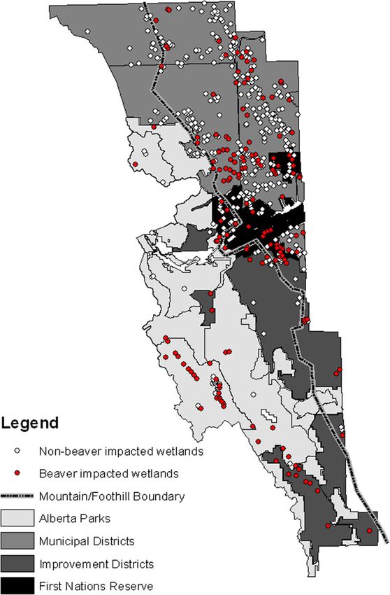
Wetlands
DOI 10.1007/s13157-014-0595-1

 ORIGINAL RESEARCH

Distribution of Canadian Rocky Mountain
Wetlands Impacted by Beaver
Alasdair Morrison & Cherie J. Westbrook &
Angela Bedard-Haughn

Received: 26 May 2014 / Accepted: 17 October 2014
# Society of Wetland Scientists 2014

Abstract Mountain wetlands, although limited in their spatial        Introduction
extent, provide many important hydrological and ecological
services. There is a need to know existing beaver habitation         Beaver (Castor canadensis and C. fiber) have long been
patterns across mountain wetlands because of emerging inter-         recognized as agents of hydrogeomorphic and ecological
est in using beaver to restore and protect riparian and wetland      change, owing largely to their dam building abilities
habitats. However, there exist few inventories of wetlands, or       (Gurnell 1998). Although best known for building dams
their use as beaver habitat, for any mountain region of North        across streams that create and maintain wetland conditions
America. We studied the distribution of beaver-impacted min-         in riparian areas (Westbrook et al. 2006), beaver can also
eral wetlands and peatlands in a 7,912 km2 area of the               inhabit pre-existing wetlands, including peatlands (Johnston
Canadian Rocky Mountains. Using aerial photography and               2012). The beaver population is believed to be rebounding in
an existing wetland database, we inventoried 529 wetlands at         North America due to conservation measures (Gibson and
elevations of 1,215 to 2,194 m; peat soils were found at 69 %        Olden 2014). Climate change may also increase the beaver
of the 81 field verified wetlands. Wetland distribution and          population; Jarema et al. (2009) predicted that the beaver
beaver habitation varied by physiography and jurisdiction.           population would respond to a warmer future climate with a
While 75 % of the wetlands identified were located in the            modest range expansion a substantial increase in density in the
foothills region, beaver were twice as likely to inhabit those in    range interior (Jarema et al. 2009). Other factors that affect the
the mountain region owing to differences in land use activities      North American beaver population include new re-
and wildlife conservation measures. Wetlands inhabited by            introduction efforts geared toward using beaver as a tool for
beaver had an order of magnitude greater area of open water          wetland restoration (Conover 2011) and water management
and 12 times the number of individual open water features            (Törnblom et al. 2011), particularly in North America's water
than those without. Beaver-enhanced open water extent has            towers, the Rocky Mountains (Baldwin 2013; Pollock et al.
far-reaching consequences for wetland ecohydrological and            2014). Information on existing beaver pond density is there-
biogeochemical functioning.                                          fore desirable (Butler 2012), but unfortunately, there exist few
                                                                     inventories of wetlands (Chimner et al. 2010), or their use as
                                                                     beaver habitat, for any mountain region of North America.
Keywords Castor canadensis . Ecohydrology . Open Water .             The purpose of this research is thus to better understand how
Peatlands . Mineral Wetlands . Inventory                             beaver modify the environment by evaluating the distribution
                                                                     and abundance of beaver ponds in mineral wetlands and
                                                                     peatlands across varying land management jurisdictions in
A. Morrison : C. J. Westbrook (*)
                                                                     the Northern Rocky Mountains.
Centre for Hydrology and Department of Geography and Planning,          Evaluating wetland extent and distribution in the moun-
University of Saskatchewan, Saskatoon, SK S7N 5C8, Canada            tains is challenging because a wide range of wetland types
e-mail: cherie.westbrook@usask.ca                                    occurs over very short distances. This is because the
                                                                     supporting hydrological characteristics can change at small
A. Bedard-Haughn
Department of Soil Science, University of Saskatchewan, Saskatoon,   spatial scales owing to variations in topography, geology and
SK S7N 5A8, Canada                                                   geochemistry (Cooper et al. 2012). Although there has yet to
Wetlands
be a systematic inventory of wetland distribution in the Rocky The boundary of the study area was determined by the avail-
Mountains as a whole, it is estimated that they make up 2 % of ability of recent (2007 and 2008) high-resolution aerial im-
the land cover, with peatlands being the most common wet- ages, and the geographical limit of the foothills region. It is
land type (Cooper et al. 2012). Inventories of peatlands in bordered to the west by Banff and Jasper National Parks. The
select areas of the Rocky Mountains have been conducted at study area forms the western margin of the Western Canada
both fine (Chadde et al. 1998; Chimner et al. 2010) and coarse sedimentary basin and is therefore geologically complex. The
(Vitt et al. 1996; Halsey et al. 1997; Zoltai et al. 2000) spatial strata (sandstone, limestone, shale and dolomite) are folded
scales, using aerial or satellite imagery. These inventories and faulted, range in age from Cambrian to Cretaceous (Toop
commonly report the presence of beaver ponds (Cooper and de la Cruz 2002), and are covered by glacial, lacustrine
et al. 2012), despite reports in the literature of peatlands being and fluvial materials (Gignac et al. 1991).
marginal beaver habitat (Rebertus 1986; Pastor et al. 1993). Elevation of the study area ranges from 1,161 to 3,427 m,
Beaver can dam stream channels in both mineral wetlands with the highest areas occurring in the Kananaskis Range in
and peatlands (Watters and Stanley 2007; Janzen and the south. The mountain region is characterized by glaciated
Westbrook 2011), but they do not require channels to build U-shaped valleys, with tarns, cirques and moraines at higher
dams (Racine and Walters 1994; Walbridge 1994). Where elevations and valleys bisected by rivers at lower elevations.
channelized surface drainage is lacking, beaver dredge canals Land use activities are restricted across the entire mountain
and dam groundwater seepage (Mitchell and Niering 1993). region, with uses such as forest harvesting permitted in the
This causes anchored mat vegetation to be eliminated or Improvement Districts but not the Provincial Parks. The foot-
partially sheared, thereby resulting in open water formation hills region is characterized by a rolling topography and more
(Ray et al. 2001; Cunningham et al. 2006). The tight arrange- varied land uses, such as ranching, recreational vehicle use,
ment of small branches in beaver dams, as compared to debris and forestry.
dams, is an architecture that further promotes upstream Beaver were extensively trapped in the study area from the
pooling of water at the land surface (Bisson et al. 2006). An 1790s through the mid-1800s, with several fur trading out-
increase in open water can fundamentally modify wetland posts on the nearby Bow (Peigan Post), Kootenay (Kootenae
structure and function, through affecting processes such as Post) and North Saskatchewan (Rocky Mountain House) riv-
water storage-runoff relations (Tardif et al. 2009), water table ers (Moore 2012). The history of fur trading with the Ktuxana,
dynamics (Janzen and Westbrook 2011) and carbon accumu- Piikani, and Niitsitapi First Nations indicates that there was an
lation rates (Blodau 2002) at the local (Wieder et al. 1981) or abundant beaver population into at least the beginning of the
regional scale (Rebertus 1986). Modification to wetland struc- 1800s (Moore 2012). Aerial photography from 1949 shows
ture and function by beaver may be temporally persistent no evidence of beaver activity in the study area; however, in
(Gorham et al. 2007) because dams and ponds in wetlands the 1970s, there was abundant evidence in the images, sug-
are less prone to washout than those in riverine environments gesting that the beaver population rebounded in the 1950s and
due to the flowing water having less energy (Ray et al. 2001). 1960s.
As a result, ponds could remain in a stable state in mineral
wetlands and peatlands for centuries (Westbrook et al. 2013). Wetland Identification and Mapping
The objectives of this research are to: 1) determine the distri-
bution and abundance of mineral wetlands and peatlands in Inventorying of wetlands in the study area involved both a
the Northern Rocky Mountains; 2) assess beaver habitation general analysis of the 2007 and 2008 aerial photography
patterns of these ecosystems; and 3) determine the impact imagery (scale 1:30,000 in nearly all instances) within a
beaver activity has on one ecohydrologically important vari- geographic information system (GIS) and field verification
able, open water extent. of a subset of the GIS identified wetlands. The 2007 images
were taken in October, and contained 202 of the wetlands. The
2008 images were taken between mid-August and mid-
Methods September, and contained 327 of the wetlands. Wetland
shapefiles available from the National Topographic Database
Study Area (NTDB; Natural Resources Canada) were used as a starting
point for the GIS wetland delineation. The wetland NTDB
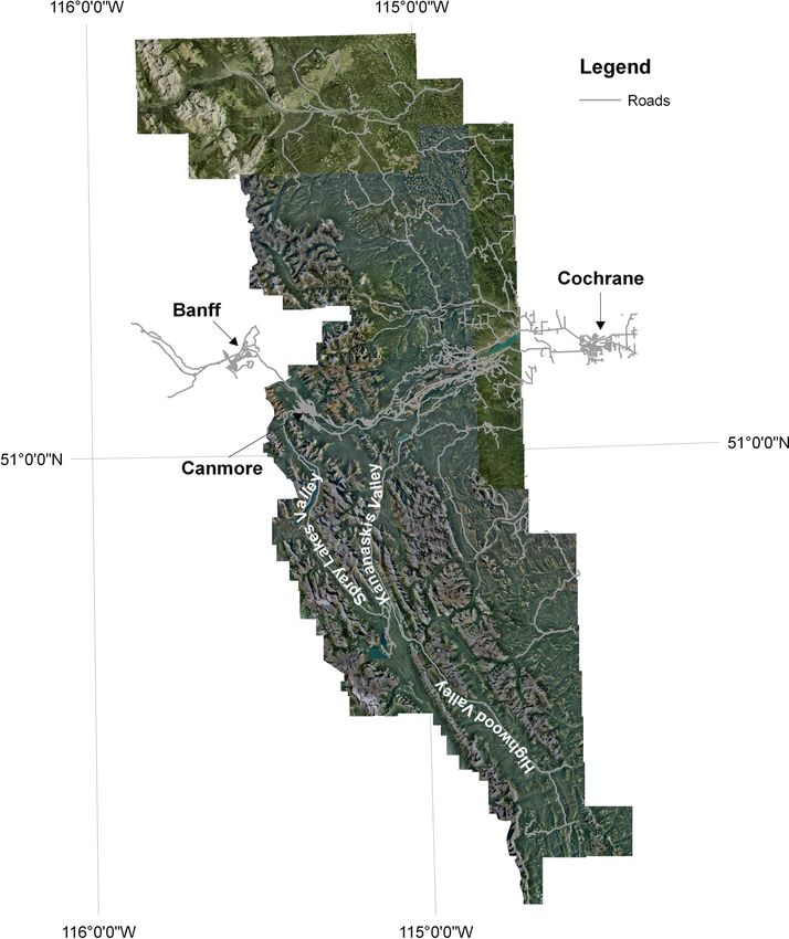
Wetland and beaver pond distributions were evaluated in a shapefiles are a summary of data gathered between 1972 and
7,912 km2 area of the Canadian Rocky Mountains west of 1996. Owing to the fact that the metadata for this GIS layer did
Calgary, Alberta (Fig. 1). The study area consists of the not describe the method by which it was produced, the wet-
entirety of Kananaskis Country (a series of protected areas – land shapefile was overlain on the 2007 and 2008 aerial
provincial parks and improvement areas), part of the Stoney- imagery and manually inspected to ensure that it did coincide
Nakoda First Nations reserve, and three Municipal Districts. with apparent wetland features. This assessment revealed thatWetlands Fig. 1 The 7,912 km2 study area in the Canadian Rocky Mountains, Alberta. Aerial images are from 2007 and 2008; linear grey features are roads the majority of the wetland polygons coincided with apparent Working Group, 1998). In each field-verified wetland, multi- wetlands on the aerial images as assessed manually. The ple cores (up to 10) were collected using a Russian corer accuracy of the shapefiles in depicting wetland location was (50 cm in length). The sampling location with the thickest also assessed during field verification, where 100 % of wet- peat deposit was used for organic matter analysis; samples of land sites identified from the shapefiles proved to be wetlands the top 40-cm from the core were sealed on-site in polypro- on the ground. We recorded the UTM coordinates of the pylene bags and refrigerated within 10 h until lab analysis. wetland centroid, wetland area, physiographic region and Samples were dried at 105 °C for 24 h, homogenized, and jurisdiction. The smallest wetland identified in the GIS anal- subsampled. Subsamples were burned in a muffle furnace at ysis was 0.2 ha; however, many wetlands smaller than this 500 °C for 5 h to determine the percentage of organic matter. were observed during the field verification. We broadly defined peatlands as both wetlands that were true To distinguish peatlands from mineral wetlands, soil or- peatlands (i.e. had at least 40 cm of peat; Soil Classification ganic composition and peat thickness were measured during Working Group (1998)) and wetlands that were peat-forming, the field verification stage using cores. The distinction be- (i.e. had at least 20 cm of continuous peat in the surface tween peat and mineral soils was based on soil organic matter 40 cm). Although a wetland must technically have at least content by mass, where peat has >30 % organic matter content 40 cm of peat to be considered a peatland, the sloping gradient and >17 % organic carbon content (Soil Classification common to mountain wetlands meant highly variable depths
Wetlands

to peat within a single wetland. This variability was             Results
compounded by interbedded mineral material in a peat matrix,
which was found in many of the wetlands.                          Distribution and Abundance of Wetlands

Assessment of Wetlands as Beaver Habitat                          Wetlands occurred at elevations between 1,215 m and 2,194 m
                                                                  throughout the study area and those that were field verified
All delineated wetlands were assessed for evidence of beaver      occurred at 1,286–1,968 m. Wetland distribution varied by both
habitation by visually inspecting the aerial images. Two basic    physiographic location and jurisdiction. The GIS inventory of
identifiers were used: 1) wetlands with ponds that had clear      wetlands identified that of the 529 wetlands, 25 % were in the
indications of being created by beaver because of identifying     mountain region and 75 % were in the foothills region. Wetland
features such as dams (linear structures), lodges (circular       density in the study area was 0.067/ km2, but there was a clear
features within ponds), and visible food caches; and 2) wet-      difference between the physiographic regions, with the moun-
lands with relict beaver structures that indicated past beaver    tains having a lower wetland density (0.026/ km2) than the
activity, but were not accompanied by the presence of ponded      foothills (0.137/km2). Alberta Parks (0.020/ km 2) and
water on the surface at the time that the image was taken.        Improvement Districts (0.026/ km2) had lower wetland density
These structures included relict dams (broken linear struc-       than Municipal Districts (0.121/ km2) and First Nations
tures) and patches of relatively homogenous vegetation that       Reserves (0.146/ km2). The Municipal Districts contained the
were different than the surrounding area (see Wright et al.       greatest number of wetlands of all the jurisdictions.
2003).                                                               We found peat soils at 69 % of the 81 field-verified wetlands
   Field verification was performed for 15 % of the 529           (Fig. 2) at elevations of 1,286–1,889 m. Proportionally fewer
delineated wetlands at a ratio of 3:1 beaver impacted to non-     wetlands in the mountains were peatlands (57 %) than in the
beaver impacted wetlands. A ranked list of the 161 beaver         foothills (71 %). The jurisdiction with the greatest proportion of
impacted wetlands identified on the aerial imagery was creat-     peatlands was the Municipal Districts (75 %), which was
ed in the database, as was a number of other metrics like         located wholly in the foothills region (Table 1). Unfortunately,
accessibility by road, number of wetlands nearby, and acces-      field verification for wetlands in the Stoney-Nakoda First
sibility during the usually wet summer conditions. Of the 129     Nation was not possible as land access was not granted.
potential wetlands listed, 81 were visited between 1 July and
20 August 2012.                                                   Wetlands as Beaver Habitat
   The GIS analysis indicated that 59 of the wetlands had
recent evidence of beaver impact and 22 did not. Field visits     Beaver impacts were evident in 30 % of the wetlands identi-
showed that of the 59 wetlands predicted to show beaver           fied (Fig. 3) across nearly the entire elevation range (1,215–
impact, two were misidentified due to an oversight during         2,152 m; Fig. 4). Distribution of beaver-created features dif-
the site selection phase, as confirmed by repeating the desktop   fered by both physiographic and jurisdictional region
methods for those sites. Of the 22 wetlands predicted to show     (Table 1). In the mountain region, 43 % of wetlands had
no clear evidence of beaver, 20 were correctly identified. The    evidence of beaver impact, whereas only 26 % of foothill
two wetlands misidentified as not having evidence of beaver
impact were a result of relict features being small and over-
grown, and the aerial imagery not having the necessary reso-
lution for identification. Therefore, the GIS delineation was
mostly accurate, with limitations in photograph quality more
likely to lead to an underestimate of beaver impacted sites
rather than an overestimate.

Open Water

Polygons were manually digitized in ArcGIS for each water
open water feature in each wetland using the aerial images
from 2007 and 2008. Although the smallest identifiable wet-
land in the GIS analysis was 0.2 ha, the smallest identifiable
area of open water within any identified wetland was 5 m2.
Open water area for wetlands impacted and not impacted by         Fig. 2 Organic content of the top 50 cm of soil at each field verified
beaver activity was compared using the Wilcoxon test because      wetland. Soils with an organic matter content of 30 % or greater were
data were non-normal.                                             considered peat
Wetlands
Table 1 Distribution of field
verified mineral wetlands and Peat-forming wetlands Mineral wetlands
peatlands by physiography, land
management jurisdiction and Wetland land status Number of Total Beaver Total Beaver
beaver habitation wetlands impacted impacted
Physiography
Mountains 28 16 16 12 12
Foothills 51 36 20 15 12
Jurisdiction
Alberta Parks 21 12 12 9 9
Municipal Districts 40 30 17 10 8
Improvement Districts 18 10 7 8 7
wetlands did. Wetlands in protected areas (i.e., Alberta Parks Evidence of recent or current beaver activity was found at
59 % and Improvement Districts 60 %) were most frequently 69 % of the field verified peatlands and 89 % of the mineral
impacted by beavers (Table 1). In contrast, the more densely wetlands. However, there were regional and jurisdictional
populated Municipal Districts had few beaver impacted wet- differences in beaver activity (Table 1). In the mountain re-
lands (20 %), although there was a cluster of beaver impacted gion, 100 % of field verified peatlands and mineral wetlands
wetlands in the southern part of this jurisdiction (Fig. 3). had evidence of past or present beaver habitation whereas only
About 40 % of wetlands in the First Nation had evidence of 56 % of peatlands and 80 % of mineral wetlands in the
beaver habitation. foothills did. All field verified peatlands and mineral wetlands
in the Alberta Parks had evidence of beaver habitation where-
as 57 to 88 % of the peatlands and mineral wetlands located in
the Municipal Districts and Improvement Areas did. There
was a clustering of peatlands with evidence of beaver activity
in the southwestern area of the Municipal Districts (Fig. 3).
Open Water
Of the 529 wetlands inventoried, 40 % had open water. Open
water area varied greatly, ranging by four orders of magnitude
(27 to 2.6×10⁴ m2). There was twice as much open water area,
on average, in mountain wetlands than foothill ones (Table 2).
Open water area accounted for 2.4 % of total wetland area in
the mountain region and 0.8 % in the foothill region.
Municipal district wetlands had considerably less open water
Fig. 3 Distribution of wetlands, as impacted by beaver, as related to
physiographic location and jurisdiction Fig 4 Histographs of mapped and field verified wetland elevationsWetlands
Table 2 Area and abundance of open water in mapped wetlands for each physiographic location and jurisdiction
No. Wetlands No. wetlands Total wetland Mean individual Total open Mean open
with open water area wetland area water area water area
Physiographic location m2 x 105 m2 x 105 m2 x 1055 m2 x 103 SE
Mountains 133 75 130.75 0.99 3.10 2.31 0.29
Foothills 396 135 604.42 1.50 4.85 1.22 0.21
Total 529 210 735.59 1.4 7.92 1.50
Jurisdictional location
Alberta Parks 59 42 42.68 0.83 1.38 2.27 0.43
Municipal Districts 361 106 556.35 1.52 2.88 0.80 0.13
Improvement Districts 42 25 56.04 1.23 1.81 4.30 1.27
First Nations Reserve 67 30 81.14 1.36 1.85 5.00 0.57
Total 529 210 735.59 1.4 7.92 1.50
area on average than the other jurisdictions owing to a greater at the near surface (Cole et al. 1997; Westbrook et al. 2006). In
total wetland area. Wetlands with beaver impact had signifi- the foothills region, wetlands also occur in low-lying posi-
cantly more (pWetlands
identified 77 % of the field-verified wetlands as peatlands or beaver tend to be perceived as a nuisance to these two indus-
peat forming wetlands. Our research complements Halsey tries (Bhat et al. 1993; Conover 1994; Messmer 2000;
et al.'s (1997) provincial peatland inventory and Zoltai Törnblom et al. 2011).
et al.'s (2000) national inventory by providing a regionally In the Improvement Districts, the proportion of beaver
dense dataset. Extending our field results to the GIS inventory impacted wetlands is 40 % higher than the Municipal
indicates that ~397 of the 529 identified wetlands could be Districts. This jurisdiction does not have the same intensity
peatlands. This is a much higher number than Chadde et al. of forestry or ranching found in the Municipal Districts.
(1998) reported for the Rocky Mountains in the northern Further, it contains some wildlife protection areas that are
United States (61 peatlands in Idaho, Washington, Montana mostly used for recreational purposes. Thus beaver are more
and Wyoming). If the ecological value (in terms of uniqueness likely to be tolerated as they are rarely directly impacting
and ecosystem services) of peatlands presented in Chadde peoples’ livelihoods. Indeed, in many cases their presence
et al. is similar for those in our study area, then the peatlands could be seen as beneficial. For example, beaver ponds are
of the greater Kananaskis region represent a substantial re- known to provide good conditions for fishing, and wildlife
gional natural resource. Given the expansiveness of the viewing as they attract a plethora of other wildlife (Conover
Canadian Rockies, its peatland resource is likely to be large. 2011). Other factors that may be important in influencing the
The challenges encountered while inventorying the local beaver population are food availability and predator
peatlands have important implications for relying solely on density. For example, the interaction of predators such as
remote sensing imagery for this task, such as is the current wolves with their prey can be complex. Elk herbivory can
trend (Krankina et al. 2008). We discovered out in the field reduce the available food source for beaver (Wolff et al. 2007),
that wetlands that appear as peatlands at the land surface, but the predation of wolves on elk reduces this impact
based on their vegetation composition and wetness, had a (Hebblewhite et al. 2005). Wolves are discouraged from living
stratigraphy in the upper 40 cm that ranged from pure peat in areas of high human population (Hebblewhite et al. 2005),
to heavily stratified with mineral layers; layers of pure peat which impacts their distribution and density.
and stratified peat were found not only in different wetlands The Alberta Parks jurisdiction had a similar proportion of
but also often at different locations within the same wetland. wetlands impacted by beaver as the Improvement Districts.
Many of those heavily stratified ended up not meeting the There are stringent rules on development and a high degree of
criteria of >17 % organic carbon by weight in the upper 40 cm wildlife protection in the park area. The unofficial policy of
(Soil Classification Working Group, 1998) and thus could not Alberta Parks is to adapt management practices to allow co-
be considered a peatland despite having many of the requisite existence with beaver, and to remove them only when abso-
functional characteristics. lutely necessary to protect infrastructure (M. Percy, pers.
comm.). That there were similar proportions of inhabited
Beaver Habitation Patterns wetlands in the parks and Improvement Districts indicates that
the suitable wetland habitat in both jurisdictions is already
Beaver disturbance varied by wetland physiographic location colonized, and that land management and land use practices in
and jurisdiction. Even though there were fewer wetlands in the the Improvement Districts are sufficient to protect beaver
mountain region, beaver impacts were twice as likely there populations. The similarity is perhaps surprising as logging
than the foothills region. While there could be a number of and seasonal grazing does occur in the Improvement Districts.
causes for this, the most likely one is differing priorities of the It may be that licensing of these activities provides adequate
main land managers in each jurisdiction. The mountain area protection of beaver, compared to logging and ranching prac-
consists primarily of Improvement Districts and Provincial tices on private land, but further study is needed.
Parks whereas the foothills region consists primarily of Interestingly, the proportion of wetlands on the First
Municipal Districts and a First Nations Reserve. None of these Nations reserve with evidence of beaver activities (40 %)
jurisdictions have an official published policy on beaver man- fell halfway between that of the protected regions and the
agement, although there is a provincial quota system to limit Municipal Districts. Physiographically, the reserve sits in
the beaver harvest. The Government of Alberta (2012) reports the foothills region, and so should be more densely im-
that the average harvest of beaver pelts from 2008 to 2012 was pacted by beaver than the Municipal Districts. Beaver
12,075. Beaver are also removed in many Alberta municipal- management policy is decided at the reserve level, and
ities as part of regular road maintenance and in response to was not publicly available for the Stoney-Nakoda First
landowner complaints. Trapping and land/infrastructure re- Nation. Without knowing more about the way beaver are
moval are thus likely to be the main causes of the low managed on the reserve, specific conclusions cannot be
proportion of wetlands (20 %) in the municipal districts found drawn other than to note that sharing of management
to have beaver ponds. Ranching and forestry may also con- strategies across jurisdictions is the region could aid in
tribute to low pond densities in the Municipal Districts as the development of a regional beaver management policyWetlands
that provides a balance of protection of both beaver and peatlands inhabited by beaver had much more of it. The idea
human interests while promoting the important ecosystem that beaver enhance open water extent in ecosystems they
services provided by beavers. inhabit is not new; there are many descriptions in the literature
Although the Municipal Districts generally had a low den- of increased open water area in riverine systems dammed by
sity of beaver-impacted wetlands, there was a high-density beaver, and how it turns lotic habitat into lentic (Johnston and
cluster in one Municipal District, coincident with the Ghost Naiman 1987; Gurnell 1998). However, the changes incurred
Valley Forest Recreation Area (GVFRA). Land use in to pre-existing wetlands (mineral and peat) are often quite
GVFRA is restricted to recreation activities such as ATV trails different than those in riverine systems. In shallow open water
and fishing and this land was an Improvement District until wetlands, such as those common in the western boreal forest
1988. Interestingly, the average distance from wetlands to a of Canada, beaver can increase the extent of flooding (Hood
road was higher within this cluster (average of just over 3 km) and Bayley 2008). For other types of wetlands though, beaver
than for other wetlands in the Municipal District (average of create open water features where they did not previously
1.5 km). High road density fragments habitats and increases occur. Although the formation of open water features by
beaver mortality through road kills (Gunther et al. 1998). Our beaver activity in wetlands, particularly peatlands has been
results suggest that the proportion of wetlands impacted by previously documented (see Johnston et al. 1990), the area is
beaver can be changed through modifying socioeconomic only infrequently quantified, and linkages to peatland hydro-
forces and/or land and wildlife management practices. If prac- logic function have yet to be explored. The form of beaver
tices are designed in a way that increases beaver inhabitation ponds are similar to peat pools in that they are open water
of wetlands, this approach is likely to help towards balancing bodies within the peat matrix, but they are different in that
human interests with the improvement of wetland functions their persistence is influenced by dam intactness (Woo and
and services (Törnblom et al. 2011). Waddington 1990). Although they did not study beaver
Peatlands, in particular, appear to be good beaver habitat: ponds, Tardif et al. (2009) showed that the presence, shape
73 % of the peatlands visited had evidence of beaver habita- and location of pools changed the way peatlands store and
tion. The widespread use of peatlands as beaver habitat con- release rain water. An important research avenue is the explo-
tradicts descriptions from the literature of peatlands as mar- ration of rainfall and snowmelt runoff generation in mountain
ginal habitat (Rebertus 1986; Pastor et al. 1993), but these mineral wetlands and peatlands as impacted by beaver ponds.
assertions were not based on scientific evidence. Studies Biogeochemical impacts of open water areas of peatlands
focused on peatlands have shown that beaver commonly have been studied, and been shown to be distinct from non-
inhabit them. For example, Milbrath (2013) described beaver open water areas. In particular, carbon (C) sequestration and
colonization patterns in nine peatlands in the Rocky Mountain release are impacted by changed wetness conditions (Belyea
foothills of Montana, and although Rebertus (1986) conclud- and Malmer 2004; Strack et al. 2005; Ise et al. 2008). For
ed that peatlands were marginal habitat, he documented that example, Roulet et al. (1997) reported a C flux from a beaver
42 % of the peatlands studied his northcentral Minnesota pond in a boreal peatland as more than 200 g C/m2 per year
study site had evidence beaver impact. Further, researchers and Crill et al. (1988) found that methane flux from an open
studying other peatland attributes have noted the presence of peat bog was 107 g C/m2 per year. Given the differences in the
beaver at their study sites (Yavitt et al. 1990; Roulet et al. climate and peatland forms present in the Canadian Rockies as
1997; Turetsky and St. Louis 2006). At a continental scale, compared to the boreal forest, along with the large enhance-
Gorham et al. (2007) showed that there is evidence of beaver ment of open water features documented here, investigations
in peatlands throughout the Holocene. This finding suggests of C dynamics in Rocky Mountain peatlands, as affected by
that beaver readily colonize peatlands. It would be interesting beaver, are warranted.
to revisit Rebertus’ study site to determine if more (or fewer)
peatlands have been colonized by beaver since his research,
given that Johnston and Naiman (1990) concluded that the
rate of pond creation after the first two decades of beaver re- Conclusions
colonization of a landscape becomes limited by lack of
geomorphically suitable habitat. Wetlands are abundant in this Rocky Mountain environment
and, despite their small areal extent, provide critical elements
One Ecohydrological Impact of Beaver on Wetlands of landscape diversity. They were physiographically
constrained mainly to valley bottom positions in the mountain
Our results indicated beaver commonly use mountain region and more evenly distributed in the foothills region
peatlands as habitat, which opened the question of resulting owing to the rolling topography. Challenges encountered
impacts on peatland function. We focused our attention on one when mapping peat wetlands serve as a cautionary note for
ecohydrological impact, open water area, and found that relying solely on digital mapping to infer wetland type. InWetlands
several cases wetlands appeared as peatlands based on their Chimner RA, Lemly JM, Cooper DJ (2010) Mountain fen distribution,
types and restoration priorities, San Juan Mountains, Colorado.
functional characteristics, but could not be classified as such
Wetlands 30:763–771. doi:10.1007/s13157-010-0039-5
because the coring revealed heavily stratified soils that did not Conover MR (1994) Perceptions of grass-roots leaders of the agricultural
meet the criteria for organic soil. community about wildlife damage on their farms and ranches. Wildl
Our research also highlights the widespread use of moun- Soc Bull 22(1):94–100
Conover D (2011) The keystone role of beavers in a restored wetland
tain wetlands, both mineral wetlands and peatlands, as beaver
(Ohio). Ecol Restor 29(3):212–213
habitat. Although our study design did not permit an in-depth Cooper DJ, Chimner RA, Merritt DA (2012) Western mountain wetlands.
evaluation, research is needed on the differences in the ways In: Batzer DP, Baldwin AH (eds) Wetland habitats of North America
beaver use mineral wetlands vs. peatlands. Even though there ecology and conservation concerns. University of California Press,
California, pp 313–328
were fewer wetlands in the mountain region, beaver impacts
Crill PM, Bartlett KB et al (1988) Methane flux from Minnesota
were twice as likely there than in the foothills region, peatlands. Glob Biogeochem Cycles 2(4):371–384
reflecting different land use zoning and wildlife management Cunningham JM, Calhoun AJK, Glanz WE (2006) Patterns of beaver
strategies. Human-wildlife interactions also appear to greatly colonization and wetland change in Acadia National Park. Northeast
Nat 13(4):583–596
enhance pooling of water on the surface of wetlands. Open
Gibson PP, Olden JD (2014) Ecology, management and conservation im-
water has far-reaching implications for wetland ecosystem plications of North American beaver (Castor canadensis) in dryland
function and service, in particular, water storage-runoff rela- streams. Aquatic Conservation doi:10.1002/aqc.2432 (2014).
tions and nutrient cycling. Specifically, the role of beaver in Gignac LD, Vitt DH, Zoltai SC, Bayley SE (1991) Bryophyte response
surfaces along climatic, chemical, and physical gradients in
delaying the transmission of runoff to downstream water
peatlands of western Canada. Nova Hedwigia 53(1–2):27–71
bodies is under-researched, which is important to know for Gorham E, Lehman C, Dyke A, Janssens J, Dyke L (2007) Temporal and
mountain wetlands, as they tend to be located at the critical spatial aspects of peatland initiation following deglaciation in North
juncture between mountain hillsides and major rivers. America. Quat Sci Rev 26:300–311
Changes in the abundance of keystone species, in this case Gunther KA, Biel MJ, Robison HL (1998) Factors influencing the
frequency of road-killed wildlife in Yellowstone National Park.
beaver, that influence water and nutrient dynamics should thus Proceedings of the international conference on wildlife, the environ-
be monitored to protect key wetland ecosystem functions. ment and transportation, Report No. FL-ER-69S58.
Gurnell AM (1998) The hydrogeomorphological effects of beaver dam-
Acknowledgements We thank Jeff Kardas for his hard work in the field building activity. Prog Phys Geogr 22(2):167–189
and May Guan and Dhiraj Pradhanaga for their jeep extraction skills. We Halabisky M, Hannam Long AL, Vondrasek C, Moskal M (2013) The
appreciate the insightful comments provided by Bob Clark, Bruce Baker sharper image: hyperspatial remote sensing of wetlands. Wetl Scie
and two anonymous reviewers. Staff at University of Calgary's Biogeo- and Prac 30(2):12–31
sciences Institute provided much needed logistical support. This research Halsey L, Vitt D, Zoltai S (1997) Alberta wetland inventory standards. In
was supported by grants from the Global Institute for Water Security and Nesby R (ed) Alberta vegetation inventory standards manual, ver-
the Natural Sciences and Engineering Research Council of Canada. sion 2.2, Alberta Environmental Protection, Alberta.
Hebblewhite M, White C et al (2005) Human activity mitigates a trophic
cascade caused by wolves. Ecology 86(8):2135–2144
Hood GA, Bayley SE (2008) Beaver (Castor canadensis) mitigate the
References effects of climate on the area of open water in boreal wetlands in
western Canada. Biol Cons 141:556–567
Ise T, Dunn A, Wofsy S, Moorcroft P (2008) High sensitivity of peat
Baldwin J (2013) Problematizing beaver habitat identification models for decomposition to climate change through water-table feedback. Nat
reintroduction application in the western United States. Yearb Assoc Geosci 1:763–766
Pac C Geo 75:104–120 Janzen KF, Westbrook CJ (2011) Hyporheic flows along a channelled
Belyea L, Malmer N (2004) Carbon sequestration in peatlands: patterns peatland: influence of beaver dams. Can Water Res J 36(4):331–347
and mechanisms of response to climate change. Glob Change Biol Jarema SI, Samson J, Mcgill BJ, Humphries MM (2009) Variation
10:1042–1052 in abundance across a species’ range predicts climate change
Bhat MG, Huffaker RG, Lenhart SM (1993) Controlling forest damage responses in the range interior will exceed those at the edge:
by dispersive beaver populations: centralized optimal management a case study with North American beaver. Glob Chang Biol
strategy. Ecol Appl 3(3):518–530 15:508–522
Bisson PA, Buffington JM, Montgomery DR (2006) Valley segments, Johnston CA (2012) Beaver wetlands. In: Batzer DP, Baldwin A (eds)
stream reaches, and channel units. In: Hauer FR, Lamberti GA (eds) Wetland habitats of North America: Ecology and Conservation
Methods in Stream Ecology, 2nd edn. Elsevier, California, pp 23–49 Concerns. University of California Press, California, pp 161–172
Blodau C (2002) Carbon cycling in peatlands: a review of processes and Johnston CA, Naiman RJ (1987) Boundary dynamics at the
controls. Environ Rev 10(2):111–134. doi:10.1139/a02-004 aquaticterrestrial interface: The influence of beaver and geo-mor-
Butler DR (2012) The impact of climate change on zoogeomorphological phology. Landscape Ecol 1:47–57
influence: examples from the Rocky Mountains of the Western Johnston C, Naiman R (1990) Aquatic patch creation in relation to beaver
U.S.A. Geomorphology 157–158:183–191 population trends. Ecology 71(4):1617–1621
Chadde S, Shelly S, Bursik R, Moseley R, Evenden A, Mantas M, Rabe Krankina ON, Pflugmacher D, Friedl M, Cohen WB, Nelson P, Baccini A
F, Heidel B (1998) Peatlands on national forests of the northern (2008) Meeting the challenge of mapping peatlands with remotely
Rocky Mountains: Ecology and conservation. US Forest Service, sensed data. Biogeosciences 5:1809–1820
Rocky Mountain Research Station, General Technical Report Lang M, McCarty G (2009) Lidar intensity for improved detection of
RMRS-GTR-11. inundation below the forest canopy. Wetlands 29(4):1166–1178Wetlands
Maxa M, Bolstad P (2009) Mapping northern wetlands with high reso- water management with a catchment perspective. Balt For
lution satellite images and lidar. Wetlands 29(1):248–260 17(1):154–161
Messmer T (2000) The emergence of human-wildlife conflict: turning Turetsky M, St. Louis V (2006) Disturbance in boreal peatlands. Ecol
challenges into opportunities. Int Biodeterior Biodegrad 45:97–102 Stud 188:359–379
Milbrath J (2013) Land cover change within the peatlands along the Vitt D, Haley L, Thormann M, Martin R (1996) Peatland inven-
Rocky Mountain Front, Montana: 1937–2009. University of tory of Alberta. Alberta Peat Task Force, Network of Centres
Montana, Thesis of Excellence in Sustainable Forest Management, University
Mitchell CC, Niering WA (1993) Vegetation change in a topogenic bog of Alberta, Alberta.
following beaver flooding. Bull Tor Bot Club 120(2):136–147 Walbridge M (1994) Plant community composition and surface water
Moore K (2012) Negotiating the middle ground in a world-system: The chemistry of fen peatlands in West Virginia's Appalachian plateau.
Niitsitapi (Blackfoot) and Ktunaxa (Kootenai) in the Northern Water Air Soil Pollut 77:247–269
Rocky Mountain Fur Trade. University of Arizona, MSc Thesis Watters JR, Stanley EH (2007) Stream channels in peatlands: the role of
Pastor J, Bonde J, Johnston C, Naiman R (1993) Markovian analysis of biological processes in controlling channel form. Geomorphology
the spatially dependent dynamics of beaver ponds. Lect Mathe iLife 89:97–110
Sc 23:5–28 Westbrook CJ, Cooper DJ, Baker BW (2006) Beaver dams and overbank
Pollock MM, Beechie TJ et al (2014) Using beaver dams to restore floods influence groundwater – surface water interactions of a
incised streams. Bioscience. doi:10.1093/biosci/biu036 Rocky Mountain riparian area. Water Resources Research 42 doi:
Racine CH, Walters JC (1994) Groundwater-discharge fens in the Tanana 10.1029/2005WR004560
lowlands, interior Alaska, U.S.A. Arct Alp Res 26(4):418–426 Westbrook C, Cooper D, Butler D (2013) Beaver geomorphology and
Ray AM, Rebertus AJ, Ray HL (2001) Macrophyte succession in hydrology. In Treatise on Geomorphology – Ecogeomorphology
Minnesota beaver ponds. Can J Bot 79:487–499 (Butler D, Hupp C, eds.), Elsevier, pp 293–306.
Rebertus AJ (1986) Bogs as beaver habitat on north-central Minnesota. Wieder RK, McCormick AM, Lang GE (1981) Vegetational analysis of
Am Midl Nat 116(2):240–245 Big Run Bog, a nonglaciated Sphagnum bog in West Virginia.
Roulet N, Crill P, Comer N, Dove A, Boubonniere R (1997) CO2 and Castanea 46(1):16–29
CH4 flux between a boreal beaver pond and the atmosphere. J Wolff E, Cooper D, Hobbs N (2007) Hydrologic regime and herbivory
Geophys Res 102(D24):29313–29319 stabilize an alternative state in Yellowstone National Park. Ecol
Strack M, Kellner E, Waddington J (2005) Dynamics of biogenic gas Appl 17(6):1572–1587
bubbles in peat and their effects on peatland biogeochemistry. Glob Woo M-K, Waddington JM (1990) Effects of beaver dams on sub-arctic
Biogeochem Cycles 19:1–9 wetland hydrology. Arctic 43:223–230
Tardif S, St-Hilaire A, Roy R, Bernier M, Payette S (2009) Statistical Wright J, Flecker A, Jones C (2003) Local vs. landscape controls
properties of hydrographs in minerotrophic fens and small lakes in on plant species richness in beaver meadows. Ecology
mid-latitude Quebec, Canada. Can Water Reso J 34(4):365–380 84(12):3162–3173
Toop D, de la Cruz NN (2002) Hydrogeology of the Canmore corridor Yavitt J, Lang G, Sexstone A (1990) Methane fluxes in wetland and forest
and northwestern Kananaskis Country. Alberta, Alberta soils, beaver ponds and low-order streams of a temperate forest
Environment, Hydrogeology Section, Edmonton, AB ecosystem. J Geophys Res 95(D13):22463–22474
Törnblom J, Angelstam P, Hartman G, Henrikson L, Sjoberg G Zoltai SC, Siltanen R, Johnson J (2000) A wetland database for the western
(2011) Toward a research agenda for water policy implemen- boreal subarctic and arctic regions of Canada. Natural Resources
tation: Knowledge about beaver (Castor fiber) as a tool for Canada, Northern Forestry Centre, Information report NOR-X-386
View publication statsYou can also read