DRAFT Otter Slough Conservation Area - Ten-Year Area Management Plan FY 2019-2028
←
→
Page content transcription
If your browser does not render page correctly, please read the page content below
DRAFT
Otter Slough Conservation
          Area
 Ten-Year Area Management Plan
                 FY 2019-2028

     To submit a comment on this document,
     click on the following link:
     https://mdc.mo.gov/node/10013?ap=309229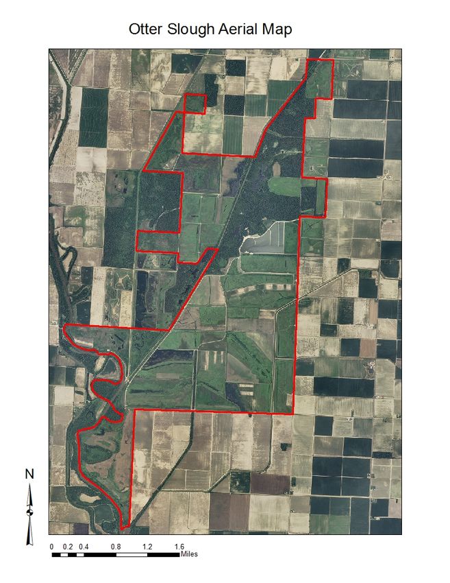
June 2018 DRAFT Otter Slough Conservation Area Management Plan Page 2
OVERVIEW
• Official Area Name: Otter Slough Conservation Area, #5004
• Year of Initial Acquisition: 1944
• Acreage: 4,859 acres
• County: Stoddard, Butler
• Region: Southeast
• Division with Administrative Responsibility: Wildlife
• Division with Maintenance Responsibility: Wildlife
• Statements of Purpose:
A. Strategic Direction
Manage and conserve a diverse wetland community that will provide compatible public
use opportunities.
B. Desired Future Condition
The desired future condition of Otter Slough Conservation Area (CA) is a diverse
wetland community with a mixture of open wetland habitats and lowland forests. These
communities will be managed for a diverse hydrology that mimics the range of historic
wetland hydroperiods previously found in the area.
C. Federal Aid Statement
• Otter Slough CA, or a portion thereof, was developed with North American Wetlands
Conservation Act funds to conserve and restore wetland habitats.
• This area, or a portion thereof, was also acquired with Pittman-Robertson Wildlife
Restoration funds to restore and manage wildlife, conserve and restore suitable
wildlife habitat, and provide public access for hunting or other wildlife-oriented
recreation.
GENERAL INFORMATION AND CONDITIONS
I. Special Considerations
A. Priority Areas: Saint Francis River Stream Reach Conservation Opportunity Area,
Otter Slough Wetland Complex Wetland Conservation Opportunity Area, Otter
Slough Wetland Complex Forest and Woodland Conservation Opportunity Area
B. Natural Areas: The 139-acre Bradyville Natural Area represents a remnant tract of
bottomland forest natural communities, including a bottomland flatwoods natural
community. The Mississippi Lowlands ecological region has lost over 80 percent of
its bottomland forest natural communities, making tracts such as these ecologically
valuable. The 20-acre Otter Slough Natural Area represents a remnant tract of
cypress-tupelo swamp that is important to a number of wetland-dependent species,
including species of conservation concern.
June 2018 DRAFT Otter Slough Conservation Area Management Plan Page 3
II. Important Natural Features and Resources
A. Species of Conservation Concern: Species of conservation concern are known from
this area. Area managers should consult the Natural Heritage Database annually and
review all management activities with the natural history biologist.
B. Caves: None
C. Springs: None
III. Existing Infrastructure
• 34 parking lots (three parking areas are Americans with Disabilities Act [ADA]
accessible)
• 21 wells
• 67 water control structures
• Levee, 42.4 miles
• Graveled field roads, 7 miles
• Field roads, 8.4 miles
• Missouri Department of Conservation (Department) roads, 10.2 miles
• 24 boat ramps
• 13 waterfowl hunting blinds (one is ADA accessible)
• Tupelo Trail, 0.4 miles
• One viewing blind (ADA accessible, at Beaver Lake)
• Two privies (both are ADA accessible)
• Three primitive camping areas
• One fishing dock (ADA accessible)
• Three fishing jetties/platforms (at Cypress Lake)
• Viewing deck/tower (at Beaver Lake)
• Cypress Lake, 93-acre fishing lake
• Otter Lake, 250-acre wetland
• Beaver Lake, 6-acre wetland
• Area Headquarters building
IV. Area Restrictions or Limitations
A. Deed Restrictions or Ownership Considerations: None
B. Federal Interest:
• This land must be used to conserve and restore wetlands. The federal funds made
available under the North American Wetlands Conservation Act may not be used
for fish and wildlife mitigation purposes under the Fish and Wildlife Coordination
Act of 1934 or the Water Resources Development Act of 1986. Federal funds may
also be used in the management of this land.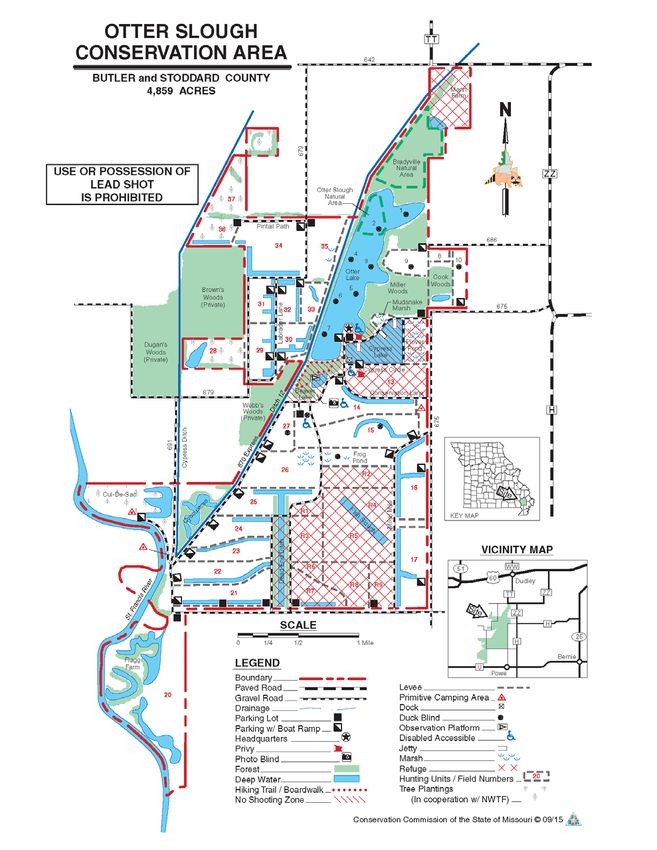
June 2018 DRAFT Otter Slough Conservation Area Management Plan Page 4
• Uses of land acquired with federal funds may not interfere with the purpose for
which it was acquired. Federal funds may also be used in the management of this
land. Fish and wildlife agencies may not allow recreational activities and related
facilities that would interfere with the purpose for which the State is managing the
land. Other uses may be acceptable and must be assessed in each specific
situation.
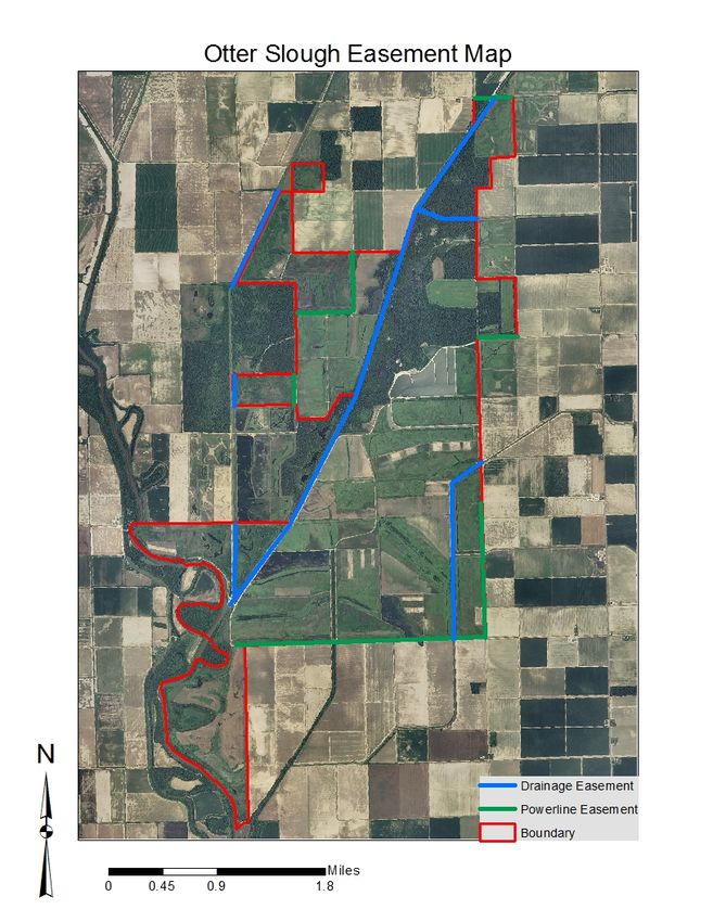
C. Easements:
• Missouri’s Drainage District 12 maintains an easement along Ditch 12 (Dudley
Main Ditch), Cypress Ditch, and an unnamed ditch that divides the Fish Slough
Refuge and Units 16 and 17.
• Powerline easements run along Units 16 and 17, R9, R7, 21, 28, and 34.
• The owners of the private inholding on the north end of the Flagg Farm are
seeking an easement, but currently are administered access with a special use
permit.
• Davis Minton maintains an easement to maintain the ditch that divides Bradyville
Natural Area and Otter Lake.
• Access to the inholding north of Unit 37 is administered through a special use
permit and no easement currently exists.
D. Cultural Resources Findings: Yes, records kept with the Missouri Department of
Conservation (Department) environmental compliance coordinators. Managers should
follow best management practices for cultural resources found in the Department
Resource Policy Manual.
E. Endangered Species: Endangered species are known from this area. Area managers
should consult the Natural Heritage Database annually and review all management
activities with the natural history biologist.
F. Boundary Issues: Establishing accurate and identifiable boundary markers is a
priority for this property.
MANAGEMENT CONSIDERATIONS
V. Terrestrial Resource Management Considerations
Challenges and Opportunities:
1) Otter Slough CA provides a diverse mixture of habitat types, including 890 acres
of bottomland forests, 465 acres of open lands, and 170 acres of old field habitat
in various stages of succession.
2) There are approximately 2,563 acres of managed wetland impoundments with
pumping and water control capabilities. Of the wetland impoundments, 214 acres
are in bottomland forest habitats and managed as Green Tree Reservoirs.
June 2018 DRAFT Otter Slough Conservation Area Management Plan Page 5
3) Some of the forested habitats on Bradyville Natural Area are wetter than historical
conditions because of impounded water caused by dredge spoil from surrounding
ditches and low levees on adjacent land. Many of the managed wetlands lack
regular hydrologic connectivity to adjacent ditches and rivers. Therefore,
dispersal for less mobile wetland-dependent species can be limited. Most of the
wetlands lack natural topography because the area was graded for agriculture
prior to the Department’s ownership. The grading of topography limits natural
wetland function and, in some areas, the top soil is no longer in place and soil
productivity is greatly reduced.
4) There are several adjacent privately-owned wetlands and tracts of forested habitat
that total approximately 2,400 acres. Outside of the habitats immediately adjacent
to Otter Slough CA, connectivity to other suitable habitats is limited to an
extremely narrow corridor along the St. Francis River.
Management Objective 1: Manage bottomland hardwood forest as habitat for a
species mix characteristic of the natural communities.
Strategy 1: Conduct forest inventories in the forested areas and developing
forested areas periodically to collect data on forest health, tree composition, and
density. (Forestry)
Strategy 2: From inventory data, develop and implement forest management
actions (harvest and forest thinning), as budget and time constraints allow.
(Forestry)
Strategy 3: Uneven-aged (or all-aged) harvest and forest thinning will be used
outside of the Bradyville Natural Area to create forest habitat conditions suitable
for wetland forest wildlife species. A long-term goal is to have 35 to 50 percent of
forested acres meet the desired stand structure, outlined in Table 2 of Restoration,
Management and Monitoring of Forest Resources in the Mississippi Alluvial
Valley: Recommendations for Enhancing Wildlife Habitat (Lower Mississippi
Valley Joint Venture Forest Resource Conservation Working Group, 2007)
(Figure 5). (Forestry, Wildlife)
Management Objective 2: Manage open wetland habitats to provide resources for
waterfowl and other wetland-dependent wildlife.
Strategy 1: Maintain native vegetation within managed impoundments and non-
forested areas. (Wildlife)
Strategy 2: Maintain at least 70 percent of herbaceous vegetation within managed
impoundments in an early successional state. (Wildlife)
Management Objective 3: Enhance wetland function on non-forested areas to
improve habitat connectivity and natural topography where feasible.June 2018 DRAFT Otter Slough Conservation Area Management Plan Page 6
Strategy 1: Enhance topographic diversity with earth-moving equipment in open
habitats, where possible. (Wildlife, Design and Development)
Strategy 2: Create avenues for wildlife and fish dispersal between and among
units, where possible (Wildlife, Fisheries, and Design and Development).
Management Objective 4: Manage Green Tree Reservoirs for wildlife habitat and
long-term forest health.
Strategy 1: Do not initiate flooding in the fall until trees have gone dormant
(known to occur when the soil temperature reaches 38 degrees Fahrenheit).
(Wildlife)
Strategy 2: Alternate flood timing, depth, and duration to mimic natural
hydrology as much as possible. (Wildlife)
Strategy 3: Dewater forested impoundments before leaf-out in the spring.
(Wildlife)
Management Objective 5: Explore possibility of restoring a more natural hydrology
to Bradyville Natural Area.
Strategy 1: Survey areas impacted by unnaturally impounded water for potential
restoration efforts. (Wildlife)
Strategy 2: Where possible, restore hydrology to a more natural regime by
removing artificial barriers to drainage. (Wildlife, Design and Development)
VI. Aquatic Resource Management Considerations
Cypress Lake is a 93-acre ‘perched reservoir’ with no watershed. It receives water from
precipitation and three wells located along the shoreline. It is a shallow lake with an
average depth less than 5 feet and maximum depth of 10 feet.
Otter Lake is a 250-acre cypress-tupelo and scrub-shrub swamp. It can be filled from
wells on Cypress Lake and near Pool 9.
Otter Slough CA has numerous ditches, borrows, oxbows, and created wetland scours.
Water can be added to some of these; others are simply conduits for water transfer, while
others catch water only from precipitation or flood events.
Challenges and Opportunities:
1) Water depth is relatively uniform across the Cypress Lake basin, making it
challenging for anglers to find fish except during spawning periods.
2) Fishing effort and harvest are high at Cypress Lake, with most anglers fishing
from shore. Predominant sportfish are largemouth bass, channel catfish, crappie,June 2018 DRAFT Otter Slough Conservation Area Management Plan Page 7
and redear sunfish. Nongame fish include common carp, gizzard shad, and
bluegill.
3) Water can be moved through Cypress Lake into adjacent wetland units.
Historically, the lake supported some aquatic macrophytes, such as pondweeds,
southern naiad, cattail, and American lotus. Other species (pickerel weed, wild
celery) were introduced with no success. Water clarity makes it difficult for
macrophytes to establish.
4) Cypress Lake is a popular roost for geese that contribute immeasurable amounts
of nutrients and the well water used to maintain the water level is high in
phosphorous. These nutrient inputs result in phytoplankton blooms. Fish kills
have resulted from phytoplankton bloom die-offs during late summer and after
extensive ice cover.
5) Otter Lake is managed for the unique habitats it provides for fish, herptiles,
plants, and wildlife.
6) Historically, water was maintained in Otter Lake year-round to allow for fishing
and waterfowl hunting. Sport fishing at Otter Lake was mediocre in the distant
past and some nongame fish were harvested. Over time a decline in the health of
the cypress and tupelo forest as well as buttonbush community was noted.
American lotus and spatterdock became dense and frequently the resulting lake
turnover caused fish kills and prevented angler access.
7) Several species of conservation concern have been collected on Otter Slough CA,
primarily from Otter Lake.
8) Sport fish are found in some of the deeper waters of area ditches/borrows/oxbows/
wetland scours during some times of the year, in particular juveniles of some
sunfish species. Nongame species use many of these waters seasonally, depending
upon water level. Fish species of conservation concern are found through much of
the year in several waters including some in which they have been transplanted.
Management Objective 1: Maintain efforts to improve water quality and minimize
fish kills on Cypress Lake.
Strategy 1: Operate lake aeration system during summer and periods of ice cover.
Monitor dissolved oxygen and water clarity (secchi depth) to determine aeration
operation periods. (Wildlife, Fisheries)
Strategy 2: Flush water through the lake using lake wells when phytoplankton
blooms are extensive. (Wildlife, Fisheries)
Management Objective 2: Manage Cypress Lake for quality sportfish populations.
Strategy 1: Monitor sportfish populations. (Fisheries)June 2018 DRAFT Otter Slough Conservation Area Management Plan Page 8
Strategy 2: Apply management techniques, when appropriate, including adjusting
channel catfish stocking rates and setting appropriate sportfish harvest
regulations. (Fisheries)
Management Objective 3: Improve angler access on Cypress Lake to cover-seeking
sportfish.
Strategy 1: Place hardwood brush fish attractors in various locations to allow
anglers to reach fish from the shoreline, fishing dock, and boats. (Wildlife,
Fisheries)
Strategy 2: Replace brush fish attractors as they deteriorate. (Wildlife, Fisheries)
Management Objective 4: Provide habitat for species of conservation concern by
improving the Otter Lake plant community and associated habitats.
Strategy 1: Conduct periodic drawdowns and allow for drying of wetland basin.
(Wildlife)
Strategy 2: Manage vegetative succession of willow and perennial plants during
drawdowns. (Wildlife)
Management Objective 5: Improve habitat for fish in other bodies of water, in
particular species of conservation concern dependent on wetland habitat.
Strategy 1: Maintain suitable water levels during dry periods in some constructed
wetlands to allow for survival of aquatic organisms and small fish, primarily
species of conservation concern. (Wildlife)
Strategy 2: Establish native aquatic vegetation historically found in shallow
wetland. (Wildlife, Fisheries)
VII. Public Use Management Considerations
Challenges and Opportunities:
1) The primary use of Otter Slough CA is by waterfowl hunters and anglers; small
game hunting, wildlife viewing, outdoor education, and managed archery deer
hunting are also popular activities for the area.
2) Numerous easily accessible viewing opportunities exist on Otter Slough, but some
roads close seasonally to limit disturbances to waterfowl and other wildlife.
3) Fishing is also closed on the area at times to limit disturbances to waterfowl and
waterfowl hunting.
4) Maintain good relationships with neighboring landowners.
5) The current level of management infrastructure at Otter Slough CA is adequate.
However, some improvements to existing infrastructure could reduce
maintenance time and expense over the long term. There are no storage facilitiesJune 2018 DRAFT Otter Slough Conservation Area Management Plan Page 9
for large equipment and it is subjected to weathering, accelerated aging, and
increased maintenance costs. Much of the infrastructure, like wells and some
water control structures, is approaching or past its reliable life expectancy.
Management Objective 1: Provide high-quality public hunting and viewing
opportunities.
Strategy 1: Conduct annual management activities that will provide habitat for a
diversity of species. (Wildlife)
Strategy 2: Manage public access to offer quality and safe outdoor experiences.
(Wildlife, Protection)
Strategy 3: Use managed hunts to promote a quality hunting experience of
waterfowl and deer. (Wildlife)
Management Objective 2: Facilitate a good working relationship with neighboring
landowners.
Strategy 1: Work with neighbors to minimize any boundary, trespass or any other
issues affecting Otter Slough CA or private property. (Wildlife)
Management Objective 3: Maintain area management infrastructure at current
levels.
Strategy 1: Maintain area infrastructure in accordance with Department guidelines
and at the currently identified maintenance level. (Wildlife)
Strategy 2: Annually maintain levees to prevent damage from encroaching trees.
(Wildlife)
Strategy 3: Monitor levees for damage and report damages to Design and
Development for repairs. (Wildlife, Design and Development)
Management Objective 4: Maintain or improve existing infrastructure to maximize
its remaining functionality.
Strategy 1: Perform routine and preventative maintenance on infrastructure.
(Wildlife, Design and Development)
VIII. Administrative Considerations
Challenges and Opportunities:
1) Consider land acquisitions, when available. There are several inholdings by
private landowners. Access is currently granted to inholdings by special use
permits. Land acquisitions could also help with improving public access, limiting
wildlife disturbances, and in some cases improving hydrologic functions and
connectivity.June 2018 DRAFT Otter Slough Conservation Area Management Plan Page 10
2) The boundary on the East side of Unit 10 is unknown. The Department shares a
levee on the East side of the Mann Farm with a private landowner and does not
own the entrance to the Mann Farm. Approximately half of the levee on the north
end of Unit 28 is owned by a private landowner.
Management Objective 1: Resolve any boundary line disputes.
Strategy 1: Clearly mark area boundary lines that are surveyed.
Strategy 2: Regularly inspect area boundary lines to ensure that they are clearly
marked, on a rotating five-year schedule or as-needed.
Lands Proposed for Acquisition:
When available, adjacent land may be considered for acquisition from willing
sellers. Tracts that improve area access, provide public use opportunities, contain
unique natural communities and/or species of conservation concern, or meet other
Department priorities, as identified in the annual Department land acquisition
priorities, may be considered.
MANAGEMENT TIMETABLE
Strategies are considered ongoing unless listed in the following table:
FY19 FY20 FY21 FY22 FY23 FY24 FY25 FY26 FY27 FY28
Terrestrial Resource Management
Objective 5
Strategy 1 XJune 2018 DRAFT Otter Slough Conservation Area Management Plan Page 11 APPENDICES Area Background: Otter Slough Conservation Area (CA) is in Stoddard County. When early explorers were making their way across what would be southeastern Missouri, they saw a seemingly endless expanse of bottomland hardwood timber and an interconnecting complex of sloughs and St. Francis River oxbows. The New Madrid earthquakes of 1811 and 1812 caused Otter Slough, Fish Slough, Lick Creek, and the Glades Swamp to combine into the large wetland now visited by thousands of migrating waterfowl. Amos Stoddard, for whom the county was named, described the region in 1812: "Nearly half of the lands... are covered with swamps and ponds, and periodically inundated. These swamps, filled with cypress, are mostly dry in the summer... Many creeks or bayous take their rise in them, and... it is calculated that there are as many as 1 to every 15 miles."(Penick, 1981). As the explorers moved on, westward expansion and settlement followed. Agricultural development was inevitable, and wetlands were converted to croplands. During the 1960s and 1970s, much of the land on and around Otter Slough CA was cleared, drained, and graded for crop farming, resulting in the decline of both resident and migratory wildlife. Of the estimated original 320,000 acres of wetlands that once existed in Stoddard County, only 6,884 acres remain. Otter Slough CA is now one of only a few examples of a cypress/tupelo swamp left in Missouri. The cypress swamp, open marsh, and flooded timber provide acorns, natural seeds, tubers, and invertebrates, all important waterfowl foods. Corn, wheat, sunflowers, and other row crops are used to maintain an open marsh condition and provide high energy food during winter months to sustain waterfowl during their long, migratory journeys. Duck numbers have exceeded 70,000 and as many as 250,000 snow geese have been recorded in the past. Although the 4,859-acre area is managed primarily for migratory and wintering waterfowl, many wading birds, shorebirds, raptors, fish, herptiles, and wetland mammals make Otter Slough CA their home.
June 2018 DRAFT Otter Slough Conservation Area Management Plan Page 12
Current Land and Water Types
Land/Water Type Acres % of Area Miles
Wetlands 2,563 53
Forest 890 18
Open Land 465 10
Infrastructure 464 10
Forested Impoundments 214 4
Old Fields 170 3
Open Water 93 2
Total 4,859 100
Stream Frontage – Ditch 12 4.8
Stream Frontage – St. Francis River 3.8
Stream Frontage – Other ditches 2.8
Stream Frontage – Cypress Ditch 1.7
References:
Lower Mississippi Valley Joint Venture Forest Resource Conservation Working Group. (2007).
Restoration, management and monitoring of forest resources in the Mississippi Alluvial
Valley: Recommendations for enhancing wildlife habitat. Wilson, R., Ribbeck, K., King,
S., & Twedt, D. (Eds.). Vicksburg, MS: LSU Printing Services.
Penick, J. L., Jr. (1981). The New Madrid earthquakes (Rev. ed.). Columbia, MO: University of
Missouri Press.
Maps:
Figure 1: Area Map
Figure 2: Aerial Map
Figure 3: Land Cover Map
Figure 4: Easement Map
Figure 5: Table 2 from Restoration, Management and Monitoring of Forest Resources in the
Mississippi Alluvial Valley: Recommendations for Enhancing Wildlife Habitat (Lower
Mississippi Valley Joint Venture Forest Resource Conservation Working Group, 2007)June 2018 DRAFT Otter Slough Conservation Area Management Plan Page 13 Figure 1: Area Map
June 2018 DRAFT Otter Slough Conservation Area Management Plan Page 14 Figure 2: Aerial Map
June 2018 DRAFT Otter Slough Conservation Area Management Plan Page 15 Figure 3: Land Cover Map
June 2018 DRAFT Otter Slough Conservation Area Management Plan Page 16 Figure 4: Easement Map
June 2018 DRAFT Otter Slough Conservation Area Management Plan Page 17 Figure 5: Table 2 – Desired Stand Conditions for Bottomland Hardwood Forests within the Mississippi Alluvial Valley (Lower Mississippi Valley Joint Venture Forest Resource Conservation Working Group, 2007)
June 2018 DRAFT Otter Slough Conservation Area Management Plan Page 18
To submit a comment on this document,
click on the following link:
https://mdc.mo.gov/node/10013?ap=309229You can also read