ECOLOGICAL IMPACT ASSESSMENT (ECIA) FOR A PROPOSED DEVELOPMENT AT DUCKSPOOL, DUNGARVAN, CO. WATERFORD.
←
→
Page content transcription
If your browser does not render page correctly, please read the page content below
Ecological Impact Assessment (EcIA) for a proposed development at
              Duckspool, Dungarvan, Co. Waterford.

                                                 5th July 2021

Prepared by: Bryan Deegan (MCIEEM) of Altemar Ltd.
Applicant: Mr Michael Ryan

          Altemar Ltd., 50 Templecarrig Upper, Delgany, Co. Wicklow. 00-353-1-2010713. info@altemar.ie
                                   Directors: Bryan Deegan and Sara Corcoran
                                     Company No.427560 VAT No. 9649832U
                                                 www.altemar.ie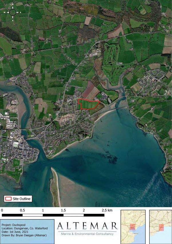
Document Control Sheet
Project    Ecological Impact Assessment (EcIA) for a proposed residential development at
           Duckspool, Dungarvan, Co. Waterford.
Report     Ecological Impact Assessment
Date       5th July 2021
Version    Author                     Reviewed                     Date
Draft 01   Bryan Deegan               Jack Doyle                   2nd June 2021
Draft 02   Bryan Deegan                                            5th July 2021
Table of Contents
Introduction .............................................................................................................................................................1
   Background ..........................................................................................................................................................1
   Study Objectives ..................................................................................................................................................1
   Altemar Ltd. .........................................................................................................................................................1
Project Description ..................................................................................................................................................2
       Drainage...........................................................................................................................................................8
       Landscape ......................................................................................................................................................11
   Ecological Assessment Methodology ................................................................................................................14
   Desk Study .........................................................................................................................................................14
   Field Survey .......................................................................................................................................................14
   Consultation ......................................................................................................................................................14
   Spatial Scope and Zone of Influence .................................................................................................................15
   Impact Assessment Significance Criteria ...........................................................................................................15
Results ...................................................................................................................................................................18
   Proximity to Designated Conservation Sites .....................................................................................................18
   Habitats and Species..........................................................................................................................................18
4 Analysis of the Potential Impacts .......................................................................................................................33
   Introduction .......................................................................................................................................................33
   Construction Impacts ........................................................................................................................................33
       Operational Impacts ......................................................................................................................................36
   Cumulative Impacts ...........................................................................................................................................44
   Residual Impacts and Conclusion ......................................................................................................................45
References .............................................................................................................................................................46
Appendix I- Wintering Bird Assessment in relation to a proposed development at Duckspool, Dungarvan, Co.
Waterford. .............................................................................................................................................................48
Introduction .............................................................................................................................................................1
   Altemar Ltd. .........................................................................................................................................................1
   Description of the Proposed Project ...................................................................................................................1
       Drainage...........................................................................................................................................................6
       Landscape ........................................................................................................................................................9
   Wintering Bird Surveys ......................................................................................................................................15
       Survey Methodology .....................................................................................................................................15
   Results ...............................................................................................................................................................18
   Potential Impacts on Wintering Birds................................................................................................................28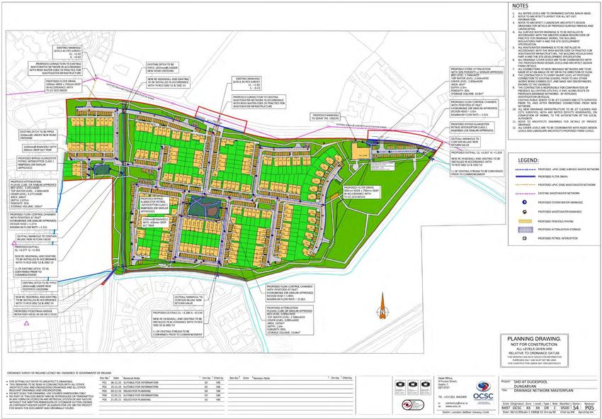
Introduction
Background
Ecological Impact Assessment (EcIA) has been defined as ‘the process of identifying, quantifying and evaluating
the potential impacts of defined actions on ecosystems or their components’ (Treweek, 1999). “The purpose of
EcIA is to provide decision-makers with clear and concise information about the likely ecological effects
associated with a project and their significance both directly and in a wider context. Protecting and enhancing
biodiversity and landscapes and maintaining natural processes depends upon input from ecologists and other
specialists at all stages in the decision-making and planning process; from the early design of a project through
implementation to its decommissioning” (IEEM, 2010).

The following EcIA has been prepared by Altemar Ltd. at the request of Michael Ryan. The project relates to an
application for planning permission for a residential development at Duckspool, Dungarvan, Co. Waterford.

Study Objectives
The objectives of this EcIA are to:

    1. Outline the project and any alternatives assessed;
    2. Undertake a baseline ecological feature, resource and function assessment of the site and zone of
       influence;
    3. Assess and define significance of the direct, indirect and cumulative ecological impacts of the project
       during its construction, lifetime and decommissioning stages;
    4. Refine, where necessary, the project and propose mitigation measures to remove or reduce impacts
       through sustainable design and ecological planning; and
    5. Suggest monitoring measures to follow up the implementation and success of mitigation measures and
       ecological outcomes.

The following guidelines have been used in preparation of this EcIA:
     • Guidelines on the information to be contained in Environmental Impact Statements (EPA, 2002);
     • Advice Notes on current practice in the preparation of EIS’s (EPA, 2003);
     • Institute of Ecology and Environmental Management Guidelines for EIA (IEEM, 2005).

A separate Appropriate Assessment Screening, in accordance with the requirements of Article 6(3) of the EU
Habitats Directive, has been produced by Altemar to identify potential impacts of the development on Natura
2000 sites, Annex species or Annex habitats. In summary, there is no possibility of significant effects on any
European Sites, features of interest or site-specific conservation objectives.

Altemar Ltd.
Since its inception in 2001, Altemar has been delivering ecological and environmental services to a broad range
of clients. Operational areas include: residential; infrastructural; renewable; oil & gas; private industry; Local
Authorities; EC projects; and, State/semi-State Departments. Bryan Deegan, the managing director of Altemar,
is an Environmental Scientist and Marine Biologist with 26 years’ experience working in Irish terrestrial and
aquatic environments, providing services to the State, Semi-State and industry. He is currently contracted to
Inland Fisheries Ireland as the sole “External Expert” to environmentally assess internal and external projects.
He is also chair of an internal IFI working group on environmental assessment. Bryan Deegan (MCIEEM) holds a
MSc in Environmental Science, BSc (Hons.) in Applied Marine Biology, NCEA National Diploma in Applied Aquatic
Science and a NCEA National Certificate in Science (Aquaculture). Bryan Deegan carried out all elements of this
Ecological Impact Assessment (EcIA).
Project Description
The proposed development site (Figures 1-3) of 8.6288 ha is located at Duckspool, Dungarvan, Co. Waterford.
The site is bound as follows: to the north by the L3168 road (which links the R675 to the east with the N25 as it
enters Dungarvan to the west), across which are the Cluain Garbhán housing estate, Scoil Gharbháin (primary
level Gaelscoil) and St. Augustine’s College (secondary level school); to the east and south-east by an
undeveloped field; and to the south and west by existing residential areas (Sallybrook and Tournore housing
estates).

The development (Figures 4 & 5) will consist of: 218 no. residential units (8 no. 1-bed, 36 no. 2-bed, 161 no. 3-
bed and 13 no. 4-bed) ranging in height from 2 no. to 4 no. storeys, comprising 42 no. duplex units (8 no. 1-bed,
32 no. 2-bed and 2 no. 3-bed) and 176 no. terraced, semi-detached and detached houses (4 no. 2-bed, 159 no.
3-bed and 13 no. 4-bed (with the option for up to 121 no. of the 3-bed houses to have attics converted, thereby
creating 4-bed houses)), with private open space as rear gardens, balconies and terraces; crèche (342.34 sq. m
GFA) and associated open space play area; 466 no. car parking spaces at surface level (430 no. within the
residential area for residents and visitors and 36 no. in the crèche and community car park), which include 24
no. mobility impaired spaces; 48 no. cycle parking spaces at surface level in 3 no. locations; bin stores (73 no.
for houses and duplexes and 1 no. for the crèche); publicly accessible open space areas (28,570 sq. m total),
which include footpaths and cycle paths, children’s play areas, planting and the incorporation of existing
hedgerows and open space; new entrances along the northern frontage, including (1) main multi-modal
entrance and junction works to the residential area, (2) one-way multi-modal entrance system (separate access
and egress) and junction works to the crèche and community car park and (3) 2 no. pedestrian and cycle
entrances; pedestrian and cycle connection to be facilitated via new bridge to the south-west into Tournore
Court; and all ancillary site services and above and below ground works to facilitate the development, including
adjustments to site levels, signage, boundary treatments, water services and public lighting.

Dungarvan Harbour SPA is proximate to the proposed development site. There is a direct pathway from the
proposed works to the SPA via drainage ditches on site. The site is surrounded on three sides by drainage
ditches. These are approximately 2m below the ground level. No other Natura 2000 sites are within the
potential Zone of Influence (ZoI). The ZoI of the proposed project would be seen to be restricted to the site
outline with potential for minor localised noise, dust and light impacts during construction. However, drainage
from site, both foul and surface water, would be seen as the outputs form the site during construction and
operation that could potentially extend the potential ZoI. Drainage ditches on site drain to the sea within the
SPA to the east of the proposed development site. As outlined in the Wintering Bird Assessment (Appendix I),
the site has been observed to be a foraging area for overwintering Brent goose (Light-bellied) (Branta bernicla
hrota), black‐tailed godwit (Limosa limosa), curlew (Numenius arquata), golden plover (Pluvialis apricaria),
lapwing (Vanellus vanellus), grey plover (Pluvialis squatarola), and redshank (Tringa tetanus), all of which are
qualifying interests of Dungarvan Harbour SPA.

As there is a direct pathway from the proposed development of the Dungarvan Harbour SPA and the landscape
strategy incorporates elements relating to wintering birds, further information is included relating to drainage
and landscape elements.
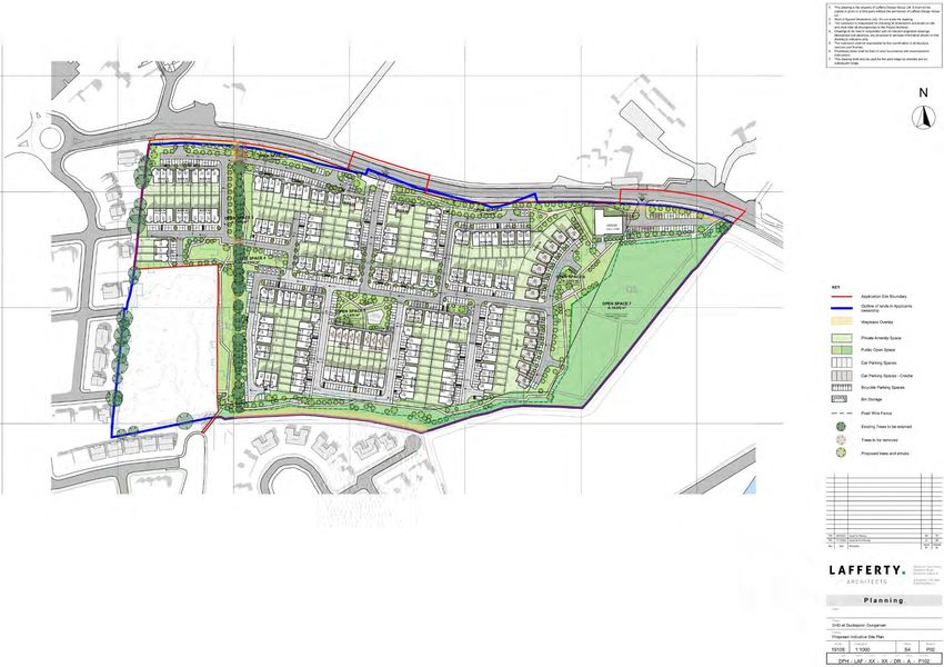
Figure 1. Proposed site outline and location
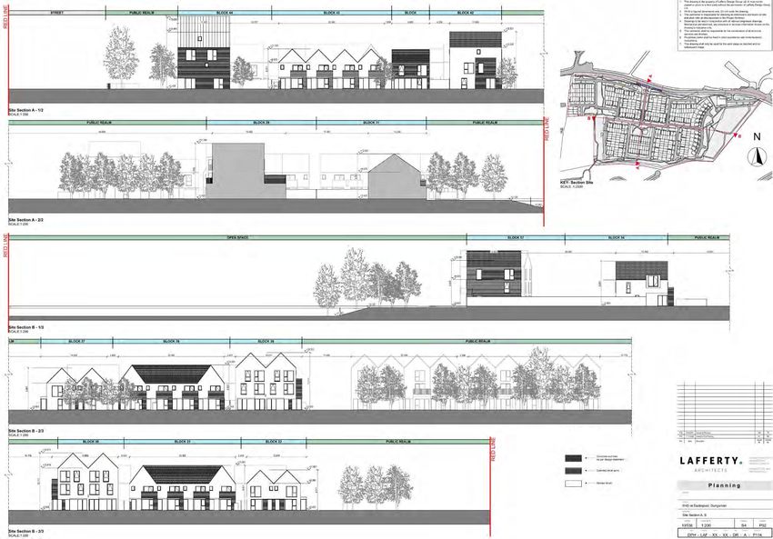
Figure 2. Proposed site outline
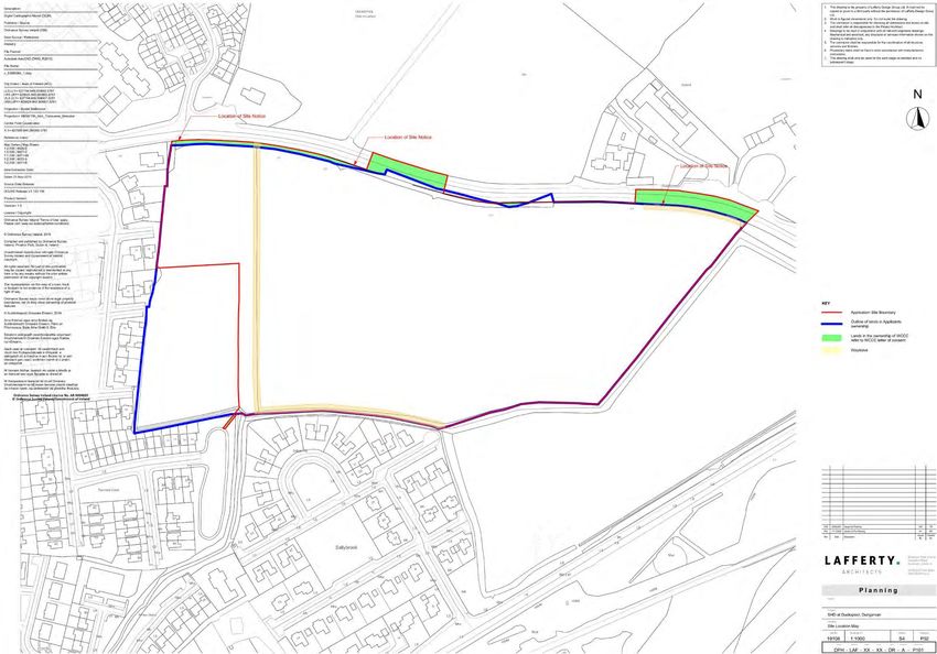
Figure 3. Site location map
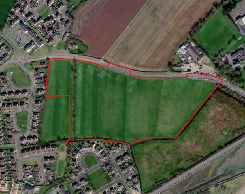
Figure 4. Proposed indicative site plan
Figure 1. Site Sections A-B

Figure 5. Proposed site sections
Drainage
OCSC Consulting Engineers were commissioned by the Applicant to prepare an Engineering Services Report
(ESR) for the proposed residential development at Duckspool, Dungarvan, Co. Waterford. The report contains
details on the foul water and surface water drainage strategies proposed for the development and details of
these strategies are outlined below.

Surface Water Drainage

The report details the existing site catchment and drainage:

‘There is no existing surface water drainage infrastructure in the vicinity of the proposed development. … the
site is currently drained by local open ditches that discharge to the Irish Sea, across Clonea Rd, to its south.’

‘There is a local highpoint near the centre of the site, with an approximate level of +3.0m AOD. The site is typically
graded from this high point to the site boundaries, with these gradients being more predominant in the southern
and eastern directions, towards a stream that aligns the site boundary.

There is also an existing tree-lined ditch that traverses the site in a north to south direction, in the western part
of the site. This ditch naturally breaks the site catchment, with the ditch discharging natural greenfield runoff to
the aforementioned L3168, at the southern boundary of the site.’

‘There is an open ditch, from the western corner of the site, and along the southern and eastern boundaries,
which conveys the natural greenfield runoff from the greater site area towards the Irish Sea, via a culvert under
the R465 and adjacent tidal floodplains.’

‘There is an additional tree-lined and vegetated ditch that traverses the site from north to south, near the
western boundary of the site, which appears to take some runoff discharge from a source north of the L3168.’

‘All surface water runoff, on the existing site, currently infiltrates to the natural ground or discharges to the local
open ditches, which in turn convey the runoff to an open watercourse.’

All of these drainage ditches drain to the culvert under the main coastal road and into Dungarvan Harbour SPA.

In terms of the proposed surface water strategy that will form part of the development, the report states:

’It is proposed to separate the surface water and wastewater drainage networks, which will serve the proposed
development, and provide independent connections to the adjacent watercourse and local wastewater sewer
network respectively.’

‘The proposed surface water network is to be split into 3nr. catchments, each of which are to discharge
attenuated flows to the open ditch / watercourse that bounds the site, to its south and east.’

‘The surface water networks are to typically comprise a gravity pipe network, with significant Sustainable
Drainage Systems implemented, where practicable. The typical traditional and Sustainable Drainage Systems
(SuDS) provided, all of which have been designed in accordance with CIRIA C753 and the SuDS Manual.’

Sustainable Drainage Systems (SuDS)

SuDs will form an integral part of the proposed development with the following elements forming part of the
overall strategy:

    •   Pervious Paving (In all private driveways)

    •   Filter Drains (Drains provided where practical)

    •   Trapped Road Gullies (On all road carriageways to trap silt and gross pollutants)

    •   Underground Pipe Network
• Silt Traps (On manholes immediately upstream of attenuation systems
• Geocellular Storage Systems
• Outlet Protection
• Flow Control Device
• Oil Separator (Class 1 bypass fuel separator to be provided prior to discharging from site)
Furthermore, the report states the following:
‘It is proposed to retain the exiting tree-lined ditch that traverses the site, in the western part of the site, with
new piped-crossings provided under the new road carriageways, where they cross. This ditch naturally acts as a
catchment boundary, with all lands east of this ditch to be drained separately to the remaining development
areas.
This catchment (Catchment A) is to discharge attenuated flows to the noted existing ditch which then flows to
the south, near the southern boundary.
The remaining part of the site, with the exception of the access to the creche, will form part of the development’s
main surface water drainage network catchment (Catchment B). This catchment is to discharge attenuated
flows to the existing watercourse at the development’s southern boundary.
The small remaining drainage catchment of the new development, which is to serve the new creche and parking
facilities, is to discharge attenuated flows to the existing watercourse to the east of the development.’
’It is proposed to reduce and restrict the rainfall runoff, discharging from the proposed development, to the
greenfield equivalent… This is to be achieved with the provision of a flow restrictor (Hydro-Brake Optimum by
Hydro-International, or similar approved) prior to discharging to the existing open drains at the north western
corner of the site, with the appropriate measures of attenuation provided. Sub-catchment flow-control devices
and associated attenuation are also to be strategically provided, in order to maximise SuDS benefits and avail
of the central open space for preliminary attenuation.’
‘The overall surface water drainage system, serving each catchment in the proposed development, is to consist
of a gravity sewer network that will convey runoff from the roofs and paved areas to the outfall manholes. The
new gravity drainage networks will discharge controlled attenuated flows to the existing open ditch’
‘Attenuation systems are to be provided at strategic locations within the development in order to temporarily
store excessive rainfall runoff, during significant rainfall events, due to the restricted discharge rates (to
greenfield equivalent runoff rates) from the development outfalls.
As noted previously, the proposed development has been split into 3nr. separate surface water drainage
catchments, to best manage the rainfall runoff. Each drainage catchment has its own independent surface water
drainage network that will require attenuation systems as a result of managing the surface water runoff flows
to greenfield equivalent runoff rates.’
‘The surface water drainage network serving Catchment A is to discharge attenuated flows to the existing tree-
lined ditch that is being retained as part of the development’s public open space provisions. The surface water
drainage networks that are to serve Catchments B and C are to discharge attenuated flows to the existing
watercourse that run along the southern and eastern boundary of the site.’
Foul Drainage
In terms of the existing foul sewer and drainage services on site, the report states:
‘The Irish Water public drainage records indicate that there is an existing public wastewater network along the
L3168, which aligns the northern boundary of the site. The sewer discharges to the Barnawee public Wastewater
Pumping Station, approximately 450m east from the proposed development’s entrance. The levels of the existingsewer were surveyed, to confirm viability of connections, and the sewer was identified as being 300mm
diameter.’
In terms of the proposed wastewater drainage strategy that will form part of the development, the report
states:
‘It is proposed to separate the wastewater and surface water drainage networks, which will serve the proposed
development, and provide independent connections to the local public foul sewer and existing open ditch
watercourse respectively.’
‘The wastewater discharge from each dwelling is to connect, via a private outfall chamber, to the new
development’s gravity wastewater network, which has been designed in accordance with the Irish Water Code
of Practice for Wastewater Infrastructure.
The overall development is to be separated into two individual gravity wastewater catchments, with the existing
tree-lined ditch acting as the catchment divide, with the number of contributing residential units as follows:
• Catchment A (western catchment) 22nr. residential units
• Catchment B (eastern catchment) 196nr. residential units
Both wastewater drainage networks are to connect to the existing public wastewater network that is located
along the L3168 road, which aligns the northern boundary of the site. It is proposed to provide a single service
connection, serving the new crèche, to the public network also.’
Flood Risk Assessment
A Site Specific Flood Risk Assessment (SSFRA) has been prepared by OCSC Consulting Engineers to support the
planning application for the proposed development.
The SSFRA concludes the following in relation to flood risks and surrounding lands:
• ‘This report identifies the flood risks at the proposed development site at Duckspool, Dungarvan.
Planning permission is currently being sought for residential development, a creche and open space
amenity development. The residential development and the creche are classified as “highly vulnerable
development” and the open space development on lands zoned as ‘OS’ is classified as “water compatible
development” in accordance with Table 3.1 of the 2009 Planning Guidelines
• The tidal and fluvial flood risk has been assessed and it is concluded that the site is within Flood Zones
A, B and C in accordance with Table 3.1 of the 2009 Planning Guidelines. Therefore, a Justification Test
has been provided.
• To achieve design objectives for density and urban design, it is proposed to rationalise the flood extent
area to create a contiguous and coherent developable area. This is achieved by raising ground levels in
areas of the existing floodplain and lowering ground level in areas outside the existing floodplain to
provide compensation. This compensation storage will be provided on a direct “level-for-level” basis, in
accordance with CIRIA C624 and the 2009 Planning Guidelines.
• All proposed buildings will be provided with a minimum FFL of 3.42mAOD, which ensures adequate
freeboard to future scenario tidal and fluvial flood levels.
• Pluvial flooding risk has been assessed and it is considered that off-site pluvial flooding is not a
significant risk. The design of internal road and FFLs should ensure that pluvial flooding is directed away
from buildings towards the existing boundary watercourses.
• It is recommended that the proposed drainage systems are designed in accordance with current best
practices and Building Regulations. Attenuation of surface water runoff should be provided, and
discharge limited to pre-development greenfield rates. In circumstances where the proposed drainage
system is constructed as designed (in accordance with the relevant standards and regulations), the floodrisks arising from the proposed drainage infrastructure will be negligible and no further mitigation is
required.
• The flood risk represented by ground water is negligible and no further mitigation is required.’
Regarding the aforementioned Justification Tests, the SSFRA states the following:
• The subject site passes the Justification Test for Development Plans.
• The subject site passes the Justification Test for Development Management.
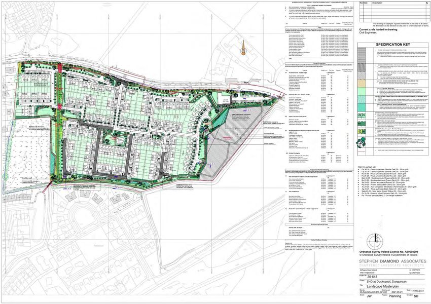
Landscape
Stephen Diamond Associates have developed a landscape design rationale and detailed landscape proposal for
the proposed residential development at Duckspool, Dungarvan. It contains eight main elements:
1 LINEAR PARK
“Establishing a green connection along wetland corridors linking school and college grounds in N.E with wider
residential areas to S.W via compacted gravel meandering pathway. Bridge crossing proposed to S.W linking
existing open green space with linear park. Resting areas provided along route as areas of high quality paving
with S.E views preserved across Dungarvan Estuary.
2 INTERNAL OPEN SPACE 1
Communal green space divided by existing way leave into seating areas to west and open green activity lawn to
east. Informal nature based play elements to occupy eastern active zone.
3 INTERNAL OPEN SPACE 2
Central communal space with pathway network connecting wider routes, areas of ornamental flowering
perennial planting, tree planting and proposed playground.
4 SHARED SURFACE -
Paved surface to roadway to prioritize pedestrian activity while establishing a strong pedestrian friendly
connection between internal open spaces and perimeter linear park.
5 OPEN GRASSLAND AREA
Grassland to eastern zone retained and separated from user circulation routes via native hedgerow, post and
wire fencing forming eastern boundary to linear park. Summer access to lands only.” This area will form a
wintering bird foraging area.
6 EXISTING WAYLEAVE
“The Linear park allows for the integration of an existing wayleave consisting of mature hedgerow vegetation
and drainage ditch allowing a strong landscaped cyclical pedestrian route to form within the development itself
while linking wider circulation for adjacent residential areas.
7 WOODLAND WALK
Native tree planting to supplement existing mature hedgerow allowing a ecological corridor to develop
southwards along wetland! drainage ditch zone and westwards as buffer to main road. Hard compacting gravel
pathway linking creche set down! car park with linear park.
8 WOODLAND BUFFER
Native woodland planted backdrop to housing allowing visual and acoustic separation from main road.”Figure 2. Drainage Masterplan Figure 6. Proposed drainage masterplan
Figure 3. Landscape plan

Figure 7. Proposed landscape masterplan
Ecological Assessment Methodology
Desk Study
A desk study was undertaken to gather and assess ecological data prior to undertaking fieldwork elements.
Sources of datasets and information included:

    •   The National Parks and Wildlife Service
    •   National Biological Data Centre
    •   Satellite, aerial and 6” map imagery
    •   Bing Maps (ArcGIS)

A provisional desk-based assessment of the potential species and habitats of conservation importance was
carried out in December 2019 and updated in June 2021. Altemar assessed the project, the proposed
construction methodology and the operation of the proposed development. It was determined that the
proposed development had the potential to impact beyond the site outline and into the surrounding
environment through dust and surface water emissions, in the absence of mitigation measures. In addition,
following the initial site visits it was determined that the proposed development site is an ex-situ foraging site
for wintering birds that are qualifying interests of the Dungarvan Harbour SPA.

Field Survey
An initial field survey was carried out by Altemar Ltd. on the 30th December 2019 following completion of the
desk-based assessment. Wintering bird surveys were carried out from the 30th December 2019 to March 2020
and from 10th September 2020 to 30th December 2020 by Bryan Deegan (MCIEEM). It was determined that
based on the 30th December 2020 count where >1%of international population of Brent Geese were observed
on site that a broader wintering bird assessment was required. This was to assess not only the numbers of
wintering birds using the site but, also evaluate the usage of the current network of ex-situ inland feeding sites
in the Dungarvan Area for Brent geese and other SPA qualifying interests, identify where the birds are currently
going and identify ex-situ sites, evaluate the site fidelity / transiency of Brent geese among the ex-situ network
of inland feeding sites in the Dungarvan area through the weekly site visits at these sites and evaluate the overall
carrying capacity of the network of inland feeding sites in the Dungarvan area for Light-bellied Brent Geese. As
a result, local ornithologist Daniel Weldon was commissioned to carry out weekly site visits to the proposed
development site and the area surrounding Dungarvan SPA from 16th January 2021 to 1st May 2021 . A detailed
methodology is outlined in the Wintering bird assessment (Appendix I). The survey was extended to May 2021
due to a particularly cold spring which resulted in the Brent geese staying in the vicinity of the Dungarvan
Harbour SPA through April 2021. A site visit was carried out by Bryan Deegan in relation to flora, fauna and
included a bat emergent survey on the 20th September 2020. The survey was carried out in mild dry conditions
and covered all the lands within the site outline and the land immediately outside the site. The purpose of the
field survey was to identify habitat types according to the Fossitt (2000) habitat classification and map their
extent. In addition, more detailed information on the species composition and structure of habitats,
conservation value and other data were gathered. A mammal assessment was carried out on 13th March 2021.

Survey Limitations

The field surveys were carried out in the appropriate time of year. This is within the period for full species
assessments of the floral cover in addition to bat surveys. Weather conditions were mild and dry and allowed
a bat detector survey to take place. Due to the cold Spring in 2021 wintering bird assessments were extended
to May 2021. No survey limitations are noted in relation to the site assessments.

Consultation
A request for data in relation to species of conservation interest was submitted to the National Parks and
Wildlife Service (NPWS). Data of rare and threatened species were provided by NPWS within 5km of the
proposed development and the information from these data is included in the EcIA. The National Biological

                                                        14
Data Centre records were consulted for species of conservation significance. As part of the SHD process
consultation has been carried out in relation to the proposed project and Waterford County Council and An
Bord Pleanála. On the 1st April 2021 a request for consultation was sent to the Development Applications Unit
of the National Parks and Wildlife Service. The reference number for the consultation is G Pre00143/2021.
However, no consultation is forthcoming from NPWS (5th July 2021).
Spatial Scope and Zone of Influence
IEEM (2006) defined the zone of influence as ‘the areas/resources that may be affected by the biophysical
changes caused by activities associated with a project’. In order to define the extent of the study area for
ecological assessment, all elements of the project were assessed and reviewed in order to identify the spatial
scale at which ecological features could be impacted. Due to the proximity of numerous drainage ditches and a
watercourse to the south of the development there is potential for the proposed development to impact
beyond the site outline into the marine environment. In addition, the project would involve excavations and
construction, which may impact beyond the site through noise, dust and light impacts. Standard construction
phase controls will need to be implemented to limit the potential impact of the proposed development into the
surrounding environment. Zone of Influence (ZoI) is the ‘effect area’ over which changes could give rise to
potentially significant impacts. The potential ZOI of the construction phase of the project was deemed to be
2km. However, the ZOI of the operation of the proposed development would be the immediate area of the
proposed development site.
Impact Assessment Significance Criteria
This section of the EcIA examines the potential causes of impact that could result in likely significant effects to
the species and habitats that occur within the ZOI of the proposed development. These impacts could arise
during either the construction or operational phases of the proposed development. The following terms are
derived from EPA EIAR Guidance and are used in the assessment (Tables 1-5) to describe the predicted and
potential residual impacts on the ecology by the construction and operation of the proposed development.
Table 1. Magnitude of impact and typical descriptions.
Magnitude of impact Typical description
(change)
High Adverse Loss of resource and/or quality and integrity of resource; severe damage to
key characteristics, features or elements.
Beneficial Large scale or major improvement of resource quality; extensive
restoration; major improvement of attribute quality.
Medium Adverse Loss of resource, but not adversely affecting the integrity; partial loss
of/damage to key characteristics, features or elements
Beneficial Benefit to, or addition of, key characteristics, features or elements;
improvement of attribute quality.
Low Adverse Some measurable change in attributes, quality or vulnerability; minor loss
of, or alteration to, one (maybe more) key characteristics, features or
elements.
Beneficial Minor benefit to, or addition of, one (maybe more) key characteristics,
features or elements; some beneficial impact on attribute or a reduced risk
of negative impact occurring
Negligible Adverse Very minor loss or alteration to one or more characteristics, features or
elements.
Beneficial Very minor benefit to or positive addition of one or more characteristics,
features or elements.
15Table 2. Criteria for Establishing Receptor Sensitivity/Importance
Importance Ecological Valuation
International Sites, habitats or species protected under international legislation e.g. Habitats and Species
Directive. These include, amongst others: SACs, SPAs, Ramsar sites, Biosphere Reserves,
including sites proposed for designation, plus undesignated sites that support populations
of internationally important species.
National Sites, habitats or species protected under national legislation e.g. Wildlife Act 1976 and
amendments. Sites include designated and proposed NHAs, Statutory Nature Reserves,
National Parks, plus areas supporting resident or regularly occurring populations of species
of national importance (e.g. 1% national population) protected under the Wildlife Acts, and
rare (Red Data List) species.
Regional Sites, habitats or species which may have regional importance, but which are not protected
under legislation (although Local Plans may specifically identify them) e.g. viable areas or
populations of Regional Biodiversity Action Plan habitats or species.
Local/County Areas supporting resident or regularly occurring populations of protected and red data
listed-species of county importance (e.g. 1% of county population), Areas containing Annex
I habitats not of international/national importance, County important populations of
species or habitats identified in county plans, Areas of special amenity or subject to tree
protection constraints.
Local Areas supporting resident or regularly occurring populations of protected and red data
listed-species of local importance (e.g. 1% of local population), Undesignated sites or
features which enhance or enrich the local area, sites containing viable area or populations
of local Biodiversity Plan habitats or species, local Red Data List species etc.
Site Very low importance and rarity. Ecological feature of no significant value beyond the site
boundary
Table3. Quality of Potential Impacts on Biodiversity
Impact Impact Description
Negative A change which reduces the quality of the environment (for example, lessening
/Adverse species diversity or diminishing the reproductive capacity of an ecosystem; or
Impact damaging health or property or by causing nuisance).
Neutral No effects or effects that are imperceptible, within normal bounds of variation or
Impact within the margin of forecasting error.
A change which improves the quality of the environment (for example, by increasing
Positive
species diversity; or the improving reproductive capacity of an ecosystem, or by
Impact
removing nuisances or improving amenities).
Table 4. Significance of Impacts
Significance of
Description of Potential Impact
Impact
Imperceptible An effect capable of measurement but without significant consequences.
An effect which causes noticeable2 changes in the character of the environment but
Not significant
without significant consequences.
An effect which causes noticeable changes in the character of the environment without
Slight Effects
affecting its sensitivities.
An effect that alters the character of the environment in a manner that is consistent
Moderate Effects
with existing and emerging baseline trends.
An effect which, by its character, magnitude, duration or intensity alters a sensitive
Significant Effects
aspect of the environment.
An effect which, by its character, magnitude, duration or intensity significantly alters
Very Significant
most of a sensitive aspect of the environment.
Profound An impact which obliterates sensitive characteristics.
16Table 5.Duration of Impact
Duration of
Description
Impact
Momentary Effects lasting from seconds to minutes
Brief Effects lasting less than a day
Temporary Effects lasting less than a year
Short-term Effects lasting one to seven years.
Medium-term Effects lasting seven to fifteen years.
Long-term Effects lasting fifteen to sixty years.
Permanent Effects lasting over sixty years
Reversible Effects that can be undone, for example through remediation or restoration
Likely Effects The effects that can reasonably be expected to occur because of the planned project if
all mitigation measures are properly implemented.
Unlikely Effects The effects that can reasonably be expected not to occur because of the planned project
if all mitigation measures are properly implemented.
Extent of Effects Description
Describe the size of the area, the number of sites, and the proportion of a population
Extent
affected by an effect.
17Results
Proximity to Designated Conservation Sites
Designated conservation sites (national and international) within 15km of the proposed development are seen
in Figures 8 - 11. It should be noted that the proposed development site is not located within a designated
conservation area, but it is proximate and does have a direct pathway to Dungarvan Harbour SPA.
The closest Natura 2000 site is the Dungarvan Harbour SPA, located 0.1 km from the proposed development
site (Figure 9). The nearest national conservation site is the Dungarvan Harbour pNHA, located 118 m from the
proposed development site (Figure 10). The nearest recorded RAMSAR site is Dungarvan Harbour, located 230
m from the proposed development site (Figure 11). Details of Natura 2000 sites are seen in Table 6, while details
on national conservation sites are in Table 7, and details of recorded RAMSAR sites are seen in Table 8.
An Appropriate Assessment Screening Report and Natura Impact Statement accompanies this application.
Following the implementation of the mitigation measures outlined, the construction and presence of this
development would not be deemed to have a significant impact. No significant impacts are likely on Natura
2000 sites, alone or in combination with other plans and projects based on the implementation of mitigation
measures. Based on the data gleaned by the Wintering Bird assessment it is considered that the loss of ex-situ
habitat for foraging wintering birds will not impact on the conservation objective attributes of “Distribution”
and “Population Trend” of any of the qualifying interest species of Dungarvan Harbour SPA.
Table 6. Distances to NATURA 2000 sites within 15km of the subject site
Site Code NATURA 2000 Site Distance
Special Areas of Conservation
002324 Glendine Wood SAC 1.8 km
000665 Helvick Head SAC 5.8 km
002170 Blackwater River (Cork/Waterford) SAC 7.7 km
001952 Comeragh Mountains SAC 8.5 km
Special Protection Areas
004032 Dungarvan Harbour SPA 0.1 km
004192 Helvick Head to Ballyquin SPA 5.8 km
004193 Mid-Waterford Coast SPA 5.8 km
Table 7. Distances to National conservation sites within 15km of the subject site
Conservation Site Name Conservation Type Distance
Dungarvan Harbour pNHA 118 m
Ballyvoyle Head to Tramore pNHA 5.7 km
Helvick Head pNHA 5.8 km
Stradbally Woods pNHA 7.3 km
Comeragh Mountains pNHA 8.5 km
Glenanna Wood pNHA 11.9 km
Ballyeelinan Wood pNHA 14 km
Table 8. Distances to National conservation sites within 15km of the subject site
RAMSAR Site Name Conservation Type Distance
Dungarvan Harbour RAMSAR 230 m
Habitats and Species
A site assessment was carried out on the 20th September 2020. Habitats within the proposed site were classified
according to Fossitt (2000) (Figure 15).
18Figure 8. Special Areas of Conservation (SAC) within 15km of proposed development site
19Figure 9. Special Protection Areas (SPA) within 15km of proposed development site
20Figure 10. National Heritage Areas (pNHA) within 15km of proposed development site
21Figure 11. Recorded RAMSAR sites within 15km of proposed development site
22Figure 12. SPAs and watercourses in close proximity to the proposed development site
23Figure 13. pNHAs and watercourses in close proximity to the proposed development site
24Figure 14. Ramsar sites and watercourses in close proximity to the proposed development site
25Figure 15. Habitats within the proposed development site classified according to Fossitt (2000).
(See the Habitat descriptions below for an explanation of the Fossitt Codes)
26As can be seen from Figure 15, the site consists of the following habitats (Fossitt, 2000):
BL3- Buildings and artificial surfaces)
No buildings are present within the site outline. Roads, paths and carparks consisting of concrete or tarmac. No
flora or fauna of conservation importance were noted in these areas.
Plate 1. Road to the north of the site.
GA1-Agricultural grassland
Agricultural grassland occupies approximately 90%s of the proposed development site. It has a relatively low
sward and cattle are noted on site for much of the year, with the exception of winter and some spring months.
Species within the grassland included, creeping buttercup (Ranunculus repens), dandelion (Taraxacum spp.),
docks (Rumex spp.), daisy (Bellis perennis), clover (Trifolium repens), plantains (Plantago spp.), thistles (Cirsium
vulgare), and nettle (Urtica dioica). No flora or fauna of conservation importance were noted in these areas.
Plate 2. GA1 Agricultural grassland.
27WS1-Scrub
Scrub is located on the south perimeters of the site in between the electric fence and stream. Species within the
scrub area included thistles (Cirsium arvense & C. vulgare), common nettle (Urtica dioica), docs (Rumex spp.),
hedge bindweed (Calystegia sepium), dog-rose (Rosa canina), rosebay Willowherb (Epilobium
angustifolium),bramble (Rubus fruticosus agg.), great Willowherb (Epilobium hirsutum), wild carrot (Daucus
carota) and devils poker (Arum maculatum).
Plate 3. Scrub
WL2- Treelines
A long treeline is located within the site and it divides the length of the site. Species within this treeline included
elder (Sambucus nigra), blackthorn (Prunus spinosa), hawthorn (Crataegus monogyna), holly (Ilex aquifolium),
ash (Fraxinus excelsior), dog-rose (Rosa canina), bramble (Rubus fruticosus agg.), , ivy (Hedera helix), honeysuckle
(Lonicera periclymenum), cleavers (Galium aparine), elm (Ulmus procera), Hawthorn (Crataegus monogyna),
Bramble (Rubus fruticosus), privet (Ligustrum vulgare). A deep drainage ditch is located parallel to the treeline.
Plate 4. Treeline with parallel drainage ditch (FW4)
28WL1- Hedgerows
Two small hedgerows are located on site. These are located on the north east corner of the site near the school
and at the opposite end of the site where it is proposed to cross the stream. Species in these hedgerows
included hawthorn (Crataegus monogyna), elder (Sambucus nigra), bramble (Rubus fruticosus), dogrose (Rosa
canina), ivy (Hedera helix), alder (Alnus glutinosa) and blackthorn (Prunusspinosa).
Evaluation of Habitats
The proposed development site is primarily on agricultrual grassland comprising a treeline, artificial surfaces
and scrub. No habitats of conservation significance were noted within the site outline. The drainage ditch (on
site) and stream to the south of the site would form a direct pathway to downstream sites. It should be noted
that there is a valve at the seaward end of the stream to prevent tidal movements inland. This would inhibit the
movement of fauna into the stream and prolong the freshwater element of the southern watercourse.
Plant Species
The plant species encountered at the various locations on site are detailed above. No rare or plant species of
conservation value were noted during the field assessment. Records of rare and threatened species from NBDC
and NPWS were examined. No rare or threatened plant species were recorded within the proposed development
site.
Invasive Plant species
No invasive plant species that could hinder removal of soil from the site during groundworks, such as Japanese
knotweed, giant rhubarb, Himalayan balsam or giant hogweed were noted on site.
Fauna
Records of rare and threatened species from NBDC and NPWS were examined. No rare or threatened faunal
species were recorded within the proposed site.
Bats
A bat survey was carried out was carried out on the 20th September 2020, and the results of the survey are seen
in Appendix II. There were no seasonal or climatic constraints as the survey was undertaken within the active bat
season in good weather conditions with temperatures of 13oC after dark. Winds were very light and there was no
rainfall. No evidence of a bat roost was found in any of the onsite trees. However, several trees on site are of bat
roosting potential. A detector survey was carried out with a Batbox Duet is a dual-mode bat detector. Foraging
activity of a soprano pipistrelle (Pipistrellus pygmaeus) and Leisler bat (Nyctalus leisleri) were noted proximate
treeline area (Appendix II).
Amphibians/Reptiles
The common frog (Rana temporaria) was not observed on site. However, there features within the site
boundary i.e. drainage ditches, that could be important to frogs. It is likely that frogs may be present on site but
were not noted during the surveys. The common lizard (Zootoca vivipara) or smooth newt (Lissotriton vulgaris)
were not recorded on site.
Terrestrial Mammals
No mammal activity was noted on site. No badgers or badger activity was noted on site. Otter (Lutra lutra) activity
was not noted on site. However, it is possible that they are present due to the presence of a nearby watercourse.
No hedgehogs were seen during the site visit, but may be present on site. No protected terrestrial mammals
were noted on site or in the vicinity of the site.
Birds
A wintering bird assessment is seen in Appendix I. The bird species noted on site outside the wintering bird
assessment are seen in Table 9.
29Table 9: Bird Species noted in the vicinity of the proposed development.
Common Name Scientific Name
Woodpigeon Columba palumbus
Wren Troglodytes troglodytes
Robin Erithacus rubecula
Blackbird Turdus merula
Blue tit Parus caeruleus
Starling Sturnus vulgaris
Great tit Parus major
Rook Corvus frugilegus
Little egret Egretta garzetta
Mallard Anas platyrhynchos
Snipe Gallinago gallinago
Assessment of Biodiversity Records
The National Biodiversity Data Centre’s online viewer was consulted in order to determine the extent of
biodiversity and/or species of interest in the area. First, an assessment of the site-specific area was carried out by
generating a report based on the site outline, however it recorded no species of interest in the site area. Following
this, a 2 km2 grid, reference number X29S, based on the Ordnance Survey Ireland (OSI) Irish Grid classification
system, was assessed.
Table 10 provides a list of all species recorded in the species reports generated for these grids that possess a
specific designation, such as Invasive Species or Protected Species.
Table 10. Table of species, NBDC
Date of Species Name Designation
Record
31/12/2011 Barn Swallow (Hirundo rustica) Protected Species: Wildlife Acts || Threatened Species: Birds
of Conservation Concern || Threatened Species: Birds of
Conservation Concern >> Birds of Conservation Concern -
Amber List
31/12/2011 Barnacle Goose (Branta Protected Species: Wildlife Acts || Threatened Species: Birds
leucopsis) of Conservation Concern || Threatened Species: Birds of
Conservation Concern >> Birds of Conservation Concern -
Amber List
31/12/2011 Bar-tailed Godwit (Limosa Protected Species: Wildlife Acts || Protected Species: EU Birds
lapponica) Directive || Protected Species: EU Birds Directive >> Annex I
Bird Species || Threatened Species: Birds of Conservation
Concern || Threatened Species: Birds of Conservation Concern
>> Birds of Conservation Concern - Amber List
31/12/2011 Black-headed Gull (Larus Protected Species: Wildlife Acts || Threatened Species: Birds
ridibundus) of Conservation Concern || Threatened Species: Birds of
Conservation Concern >> Birds of Conservation Concern - Red
List
31/12/2011 Black-tailed Godwit (Limosa Protected Species: Wildlife Acts || Threatened Species: Birds
limosa) of Conservation Concern || Threatened Species: Birds of
Conservation Concern >> Birds of Conservation Concern -
Amber List
31/12/2011 Brent Goose (Branta bernicla) Protected Species: Wildlife Acts || Threatened Species: Birds
of Conservation Concern || Threatened Species: Birds of
Conservation Concern >> Birds of Conservation Concern -
Amber List
31/12/2011 Common Greenshank (Tringa Protected Species: Wildlife Acts || Threatened Species: Birds
nebularia) of Conservation Concern || Threatened Species: Birds of
30Conservation Concern >> Birds of Conservation Concern -
Amber List
31/12/2011 Common Redshank (Tringa Protected Species: Wildlife Acts || Threatened Species: Birds
totanus) of Conservation Concern || Threatened Species: Birds of
Conservation Concern >> Birds of Conservation Concern - Red
List
31/12/2011 Common Shelduck (Tadorna Protected Species: Wildlife Acts || Threatened Species: Birds
tadorna) of Conservation Concern || Threatened Species: Birds of
Conservation Concern >> Birds of Conservation Concern -
Amber List
31/12/2011 Common Starling (Sturnus Protected Species: Wildlife Acts || Threatened Species: Birds
vulgaris) of Conservation Concern || Threatened Species: Birds of
Conservation Concern >> Birds of Conservation Concern -
Amber List
31/12/2011 Common Swift (Apus apus) Protected Species: Wildlife Acts || Threatened Species: Birds
of Conservation Concern || Threatened Species: Birds of
Conservation Concern >> Birds of Conservation Concern -
Amber List
31/12/2011 Common Wood Pigeon Protected Species: Wildlife Acts || Protected Species: EU Birds
(Columba palumbus) Directive || Protected Species: EU Birds Directive >> Annex II,
Section I Bird Species || Protected Species: EU Birds Directive
>> Annex III, Section I Bird Species
31/12/2011 Dunlin (Calidris alpina) Protected Species: Wildlife Acts || Protected Species: EU Birds
Directive || Protected Species: EU Birds Directive >> Annex I
Bird Species || Threatened Species: Birds of Conservation
Concern || Threatened Species: Birds of Conservation Concern
>> Birds of Conservation Concern - Amber List
31/12/2011 Eurasian Curlew (Numenius Protected Species: Wildlife Acts || Protected Species: EU Birds
arquata) Directive || Protected Species: EU Birds Directive >> Annex II,
Section II Bird Species || Threatened Species: Birds of
Conservation Concern || Threatened Species: Birds of
Conservation Concern >> Birds of Conservation Concern - Red
List
31/12/2011 Eurasian Oystercatcher Protected Species: Wildlife Acts || Threatened Species: Birds
(Haematopus ostralegus) of Conservation Concern || Threatened Species: Birds of
Conservation Concern >> Birds of Conservation Concern -
Amber List
31/12/2011 Eurasian Teal (Anas crecca) Protected Species: Wildlife Acts || Protected Species: EU Birds
Directive || Protected Species: EU Birds Directive >> Annex II,
Section I Bird Species || Protected Species: EU Birds Directive
>> Annex III, Section II Bird Species || Threatened Species:
Birds of Conservation Concern || Threatened Species: Birds of
Conservation Concern >> Birds of Conservation Concern -
Amber List
31/12/2011 Great Black-backed Gull (Larus Protected Species: Wildlife Acts || Threatened Species: Birds
marinus) of Conservation Concern || Threatened Species: Birds of
Conservation Concern >> Birds of Conservation Concern -
Amber List
31/12/2011 Great Cormorant (Phalacrocorax Protected Species: Wildlife Acts || Threatened Species: Birds
carbo) of Conservation Concern || Threatened Species: Birds of
Conservation Concern >> Birds of Conservation Concern -
Amber List
31/12/2011 House Martin (Delichon Protected Species: Wildlife Acts || Threatened Species: Birds
urbicum) of Conservation Concern || Threatened Species: Birds of
Conservation Concern >> Birds of Conservation Concern -
Amber List
31/12/2011 House Sparrow (Passer Protected Species: Wildlife Acts || Threatened Species: Birds
domesticus) of Conservation Concern || Threatened Species: Birds of
Conservation Concern >> Birds of Conservation Concern -
Amber List
31/12/2011 Lesser Black-backed Gull (Larus Protected Species: Wildlife Acts || Threatened Species: Birds
fuscus) of Conservation Concern || Threatened Species: Birds of
31Conservation Concern >> Birds of Conservation Concern -
Amber List
31/12/2011 Little Egret (Egretta garzetta) Protected Species: Wildlife Acts || Protected Species: EU Birds
Directive || Protected Species: EU Birds Directive >> Annex I
Bird Species
31/12/2011 Mallard (Anas platyrhynchos) Protected Species: Wildlife Acts || Protected Species: EU Birds
Directive || Protected Species: EU Birds Directive >> Annex II,
Section I Bird Species || Protected Species: EU Birds Directive
>> Annex III, Section I Bird Species
31/12/2011 Mute Swan (Cygnus olor) Protected Species: Wildlife Acts || Threatened Species: Birds
of Conservation Concern || Threatened Species: Birds of
Conservation Concern >> Birds of Conservation Concern -
Amber List
31/12/2011 Northern Lapwing (Vanellus Protected Species: Wildlife Acts || Protected Species: EU Birds
vanellus) Directive || Protected Species: EU Birds Directive >> Annex II,
Section II Bird Species || Threatened Species: Birds of
Conservation Concern || Threatened Species: Birds of
Conservation Concern >> Birds of Conservation Concern - Red
List
31/12/2011 Northern Shoveler (Anas Protected Species: Wildlife Acts || Protected Species: EU Birds
clypeata) Directive || Protected Species: EU Birds Directive >> Annex II,
Section I Bird Species || Protected Species: EU Birds Directive
>> Annex III, Section III Bird Species || Threatened Species:
Birds of Conservation Concern || Threatened Species: Birds of
Conservation Concern >> Birds of Conservation Concern - Red
List
31/12/2011 Red-breasted Merganser Protected Species: Wildlife Acts || Protected Species: EU Birds
(Mergus serrator) Directive || Protected Species: EU Birds Directive >> Annex II,
Section II Bird Species
21/07/2003 Butterfly-bush (Buddleja davidii) Invasive Species: Invasive Species || Invasive Species: Invasive
Species >> Medium Impact Invasive Species
21/07/2003 Field Penny-cress (Thlaspi Invasive Species: Invasive Species || Invasive Species: Invasive
arvense) Species >> Medium Impact Invasive Species
07/05/2017 Japanese Knotweed (Reynoutria Invasive Species: Invasive Species || Invasive Species: Invasive
japonica) Species >> High Impact Invasive Species || Invasive Species:
Invasive Species >> Regulation S.I. 477 (Ireland)
25/07/2002 Little-robin (Geranium Threatened Species: Endangered
purpureum)
12/04/2014 Round-leaved Crane's-bill Threatened Species: Endangered
(Geranium rotundifolium)
08/04/2004 Sycamore (Acer pseudoplatanus) Invasive Species: Invasive Species || Invasive Species: Invasive
Species >> Medium Impact Invasive Species
08/04/2004 Traveller's-joy (Clematis vitalba) Invasive Species: Invasive Species || Invasive Species: Invasive
Species >> Medium Impact Invasive Species
29/08/1997 Turkey Oak (Quercus cerris) Invasive Species: Invasive Species || Invasive Species: Invasive
Species >> Medium Impact Invasive Species
25/07/2002 Wall Cotoneaster (Cotoneaster Invasive Species: Invasive Species || Invasive Species: Invasive
horizontalis) Species >> Medium Impact Invasive Species
22/05/2014 Brown Rat (Rattus norvegicus) Invasive Species: Invasive Species || Invasive Species: Invasive
Species >> High Impact Invasive Species || Invasive Species:
Invasive Species >> Regulation S.I. 477 (Ireland)
31/12/2015 Eurasian Badger (Meles meles) Protected Species: Wildlife Acts
14/04/2010 Eurasian Pygmy Shrew (Sorex Protected Species: Wildlife Acts
minutus)
07/06/2015 Eurasian Red Squirrel (Sciurus Protected Species: Wildlife Acts
vulgaris)
28/08/2013 European Otter (Lutra lutra) Protected Species: EU Habitats Directive || Protected Species:
EU Habitats Directive >> Annex II || Protected Species: EU
32You can also read