Economic Assessment: 404 Omokoroa Road - May 2020 - Prepared for Kiwi Green New Zealand Ltd - Western Bay of ...
←
→
Page content transcription
If your browser does not render page correctly, please read the page content below
Economic Assessment: 404 Omokoroa Road
                                  May 2020

                Prepared for Kiwi Green New Zealand Ltd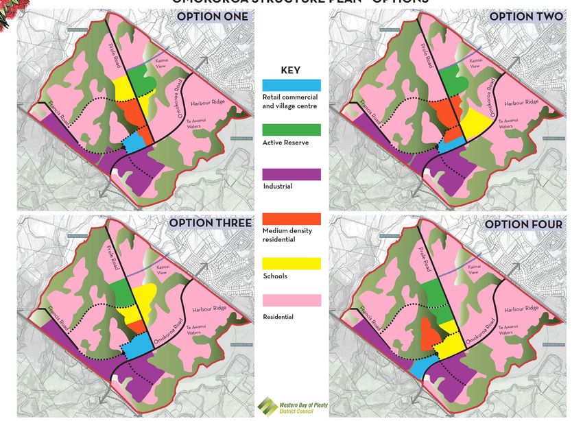
DISCLAIMER

 Every effort has been made to ensure the soundness and accuracy of the opinions,
 information, and forecasts expressed in this report.

 Information, opinions and forecasts contained in this report should be regarded solely as a
 general guide. While we believe statements in the report are correct, no liability is accepted
 for any incorrect statement, information or forecast. RCG disclaims any liability that may
 arise from any person acting on the material within.

 RCG Ltd is the author of this report, and therefore holds all copyright and intellectual
 property rights relating to it. RCG requires that all parties permitted to use the report and
 the research contained within the report give full and correct acknowledgement of its
 authorship.

 DOCUMENT CONTROL

 Document ID: 001-2020-20013

Code        Date                           Version   Author
02          May 2020                       Final     John Polkinghorne
                                                     Associate Director

 RCG LTD
 11 CHESHIRE ST
 PO BOX 137313
 PARNELL, AUCKLAND
 P +64 9 303 1501 F +64 9 303 1506
 www.rcg.co.nz

 RCG LIMITED | CONSTRUCTIVE THINKING DELIVERED                 OMOKOROA ECONOMIC ASSESSMENT | MAY 2020   1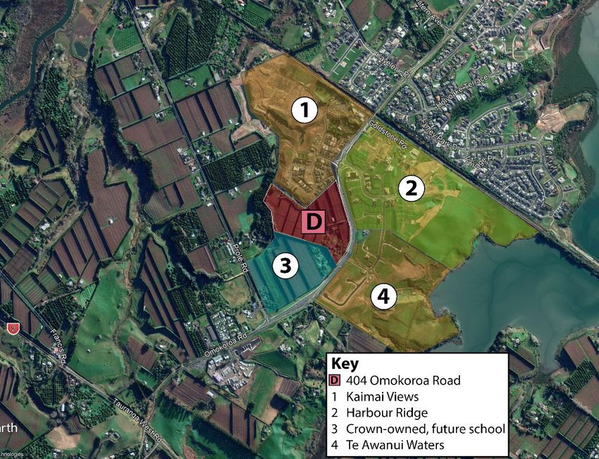
Contents
Contents ............................................................................................................................................... 2
1       Introduction ............................................................................................................................... 3
2       The Site and Context ............................................................................................................... 4
3       Other Retail Precincts ............................................................................................................ 6
4       Review of Previous Studies.................................................................................................. 9
5       Population and Capacity .....................................................................................................13
6       Planning Considerations .....................................................................................................16
7       2018 Consultation Options ................................................................................................19
8       Assessment of Economic Effects ......................................................................................21

Abbreviations and Definitions
We use various abbreviations and definitions in this report, including:

       • CBD – Central Business District
       • F&B – Food and Beverage
       • SH – State Highway
       • Stats NZ – Statistics New Zealand
       • WBOPDC – Western Bay of Plenty District Council

RCG LIMITED | CONSTRUCTIVE THINKING DELIVERED                                                OMOKOROA ECONOMIC ASSESSMENT | MAY 2020                         2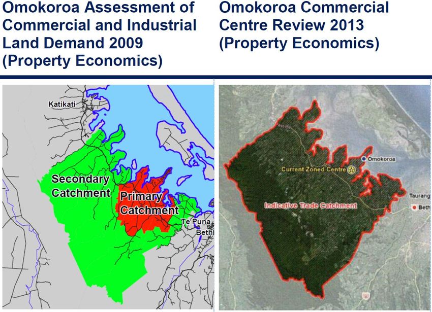
1 Introduction
Kiwi Green New Zealand Ltd owns a 7.9 hectare site at 404 Omokoroa Road. They intend to
apply for resource consent to develop part of the site (zoned Commercial) as a town centre.

RCG has been engaged to assess the economic effects of this proposal. Our work has
included:

       • An overview of the site and its context within Omokoroa, a long-identified growth
         area;
       • Comments on other retail precincts in Omokoroa and surrounding areas;
       • A review of past economic studies for Omokoroa;
       • Compiling data on population and household numbers (past and future
         ‘projections’), and building consents;
       • Comments on strategic planning issues as they relate to economics;
       • Comments on the Council’s ‘consultation options’ for a new structure plan in 2018;
       • Assessing the economic effects of the proposed development.

RCG LIMITED | CONSTRUCTIVE THINKING DELIVERED            OMOKOROA ECONOMIC ASSESSMENT | MAY 2020   3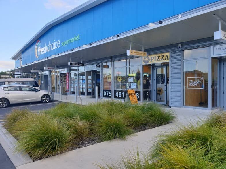
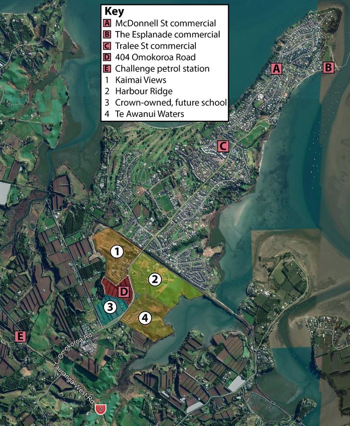
2 The Site and Context
404 Omokoroa Road is a 7.9 hectare site, partly zoned Commercial and with the rear
portions of the site zoned Future Urban. It is the Commercial part that our report focuses on.

2.1 The Commercial Zone
This Commercial zone was identified as a future town centre for Omokoroa some years ago,
which is reflected in the Operative District Plan (ODP) and the existing Omokoroa Structure
Plan (part of Appendix 7 to the ODP). The zone stretches across parts of several properties,
including: 404 Omokoroa Road; the area now being developed as ‘Kaimai Views’; and 412-
426 Omokoroa Road, which have recently been bought by the Crown for a future school.

As such, although the wider Commercial zone covers some 12.7 hectares, it is only the 404
Omokoroa Road portion (approx. 5.0 hectares) that is still available for commercial
development.

2.2 Site Context
404 Omokoroa Road is adjacent to the Kaimai Views subdivision, and across the road from
Harbour Ridge and Te Awanui Waters. All three subdivisions are still in progress, with new
stages being developed and new homes being built.

Figure 2.1: Site Context for 404 Omokoroa Road

Source: RCG
RCG LIMITED | CONSTRUCTIVE THINKING DELIVERED           OMOKOROA ECONOMIC ASSESSMENT | MAY 2020   4
As shown in Figure 2.1 above, the proposed school site is immediately south of 404
Omokoroa Rd, with residential subdivisions to the north and east.

Other than the developments and sites identified above, most parts of Omokoroa south of
the railway line are zoned Future Urban, and would require a plan change or structure plan
process to be developed. However, there is an area of live industrial-zoned land east of
Omokoroa Rd.

2.3 Omokoroa Background
Omokoroa used to be a small coastal village, and as late as 1986 the peninsula had only
1,100 people. Western Bay of Plenty District Council (WBOPDC) consultation material from
2018 notes that:

            “Omokoroa was earmarked for growth as far back as the 1970s. It grew in various
            stages up to the 1990s when pollution from septic tanks into the harbour halted this…

            In 2007 the peninsula’s wastewater was reticulated and septic tanks were
            disestablished. At that time planning was put in place to urbanise the area between the
            [Omokoroa Country Estate retirement village] and the railway. This was Stage 1 of
            Omokoroa’s urban planning.

            Stage 2 occurred in 2010 and zoned the residential areas south of the railway that are
            now under development (Kaimai Views, Harbour Ridge, and Te Awanui Waters), and
            the industrial area around where Omokoroa General Carriers are”.1

404 Omokoroa Road was also rezoned as part of the Stage 2 planning process.

Even now, Omokoroa is still at an early stage of its development – although it is growing
fast. We look into this in more detail in section 5.

1   https://haveyoursay.westernbay.govt.nz/39550/widgets/218050/documents/88423
RCG LIMITED | CONSTRUCTIVE THINKING DELIVERED                OMOKOROA ECONOMIC ASSESSMENT | MAY 2020   5
3 Other Retail Precincts 3.1 Omokoroa There are several small retail areas on the Omokoroa peninsula, shown in Figure 3.1 below: Figure 3.1: Omokoroa Retail Areas Source: RCG Aside from Tralee Street, and 404 Omokoroa Rd which is not yet developed, these retail areas are all very small in size, consisting of only a handful of shops each. RCG LIMITED | CONSTRUCTIVE THINKING DELIVERED OMOKOROA ECONOMIC ASSESSMENT | MAY 2020 6
Tralee Street
The Tralee Street Commercial zone covers 3.7 hectares of land, spread over several sites.
These include:

       • 168 Omokoroa Rd, older industrial premises which now also contain Super Liquor
         and some food & beverage (The Local Bar & Eatery etc);
       • Omokoroa Community Church, which opened in 2002;
       • The Omokoroa Medical Centre development, which opened in 2011;
       • The 1.0 hectare Fresh Choice development, which opened in 2016;
       • A 1.7 hectare site at 97-137 Hamurana Rd which is still undeveloped (but has
         resource consent for a mixed-use development – see below).

The Fresh Choice development, developed and still owned by Woolworths New Zealand,
consists of an 1,100 sqm Fresh Choice and six small shops totalling 486 sqm (source –
Ground Floor Plan shown on real estate listings). This development means Omokoroa
residents can now do some of their grocery shopping locally – before 2016, the only food
offering was dairies.

Figure 3.2: Fresh Choice and Small Shops

Source: https://www.realestate.co.nz/2600554/commercial/lease/tenancy2-omokoroa-road-
omokoroa

97-137 Hamurana Rd has not yet been developed, but resource consent for a mixed-use
development was granted in late 2019. The consent allows for a mix of terraced residential,
RCG LIMITED | CONSTRUCTIVE THINKING DELIVERED          OMOKOROA ECONOMIC ASSESSMENT | MAY 2020   7
commercial and retail uses. In total, there is 4,244 sqm of ground floor space which is expected to include a mix of medical, retail, F&B and commercial activity. 3.2 Katikati and Te Puna Katikati has a typical offering for a town of its size: ‘main street’ focused, with a single supermarket (Countdown, roughly 3,200 sqm and located in the Industrial zone to the south of the main town centre), and a variety of convenience/ F&B/ service providers. This offering meets the ‘everyday’ needs of the Katikati community, but for a wider offering people would travel to Tauranga (a 35-minute drive away). Te Puna has a small retail/ service offering around the intersection of State Highway 2/ Te Puna Rd/ Minden Rd. This includes Four Square, BP, real estate and accountancy offices, Te Puna Motel, Farmlands, a tavern and a backpackers. We would characterise most of this offering as convenience/ rural-oriented, relying mainly on the local community and partly on drive-by traffic. 3.3 Tauranga Retail Centres Bethlehem has a sizeable offering, with the main retail centre (opened in 2007) now including Countdown, Kmart, a smaller Smiths City store, and a range of convenience/ F&B/ service providers. The centre struggled in the early years, as it had opened all at once rather than in stages as its catchment grew. Part of the specialty space was demolished in order to make way for Kmart, which opened in 2016. Since this strong ‘anchor tenant’ opened, the centre appears to have become much more successful. Other nearby retailers include Palmers, Z Energy, unstaffed Gull pumps, and several retail/ commercial blocks. In Tauriko, Tauranga Crossing has now become the largest shopping centre in the Bay of Plenty, with 45,000 sqm of lettable area. Future stages could take this to 70,000 sqm. Currently, it includes Pak N Save, The Warehouse, Farmers and a wide range of specialty retailing. Other key retail destinations in Tauranga include the City Centre and Bayfair. RCG LIMITED | CONSTRUCTIVE THINKING DELIVERED OMOKOROA ECONOMIC ASSESSMENT | MAY 2020 8
4 Review of Previous Studies
We are aware of three previous economic reports for Omokoroa.

       • An October 2009 report by Property Economics, titled “Omokoroa Assessment of
         Commercial & Industrial Land Demand” and prepared for WBOPDC. We assume this
         report was an input into the 2010 ‘stage 2’ structure planning;
       • An August 2013 report by Property Economics, titled “Omokoroa Commercial
         Centre Review” and prepared for Foodstuffs;
       • A March 2018 report by RPS Australia, titled “Omokoroa Structure Plan Economic
         Review” and prepared for WBOPDC.

Both Property Economics reports were based on 2006 census data, as they were published
before any 2013 data was released. RPS Australia would have had access to all 2013 census
data and census-derived releases (e.g. population projections). However, none of the three
reports had access to 2018 census data, as this was only released in late 2019.

The RPS Australia report is in large part a review of the two earlier reports, together with
updated data where available, and new recommendations for the Council.

4.1 Catchment/ Trade Area Definition
The two Property Economics reports use the same overall catchment, but the 2009 report
makes a distinction between the ‘primary’ and ‘secondary’ parts. This is an important
distinction, in our view. RPS did not create a new catchment definition, but simply reused
the Property Economics one – distinguishing between the primary and secondary parts.

RCG LIMITED | CONSTRUCTIVE THINKING DELIVERED          OMOKOROA ECONOMIC ASSESSMENT | MAY 2020   9
The overall catchment from the two Property Economics reports is shown below:
Figure 4.1: Property Economics Catchment Definitions
Source: Property Economics 2009 and 2013, RPS 2018
The 2009 Property Economics report noted:
“The proposed commercial centre (the Omokoroa Town Centre) will have a clear
locational advantage for residents in the Primary Catchment. The Omokoroa Town
Centre will attract a smaller portion of the retail spend from the Secondary Catchment,
as residents will also have ready access to Katikati, Bethlehem and other Tauranga
centres, particularly those residents that travel outside of the local area for
employment”.
RPS note that the Property Economics definitions are slightly narrower than Stats NZ area
units – i.e. they include all of the Omokoroa and Te Puna area units, but only part of the
Aongatete and Minden area units.
RCG LIMITED | CONSTRUCTIVE THINKING DELIVERED OMOKOROA ECONOMIC ASSESSMENT | MAY 2020 104.2 Population Growth
As RPS note, “the 2009 [Property Economics] projections assume a much higher growth rate
than the later (2013) projections”.
The 2009 Property Economics report assumed that the Primary Trade Area would grow
from 5,700 people in 2009 to 12,500 people in 2026, with slower growth in the Secondary
Trade Area – from 4,400 to 5,900 people. The total catchment would grow from 10,100 to
18,400 people, growth of 8,300 or 82%.
The 2013 Property Economics report assumed that the total catchment would grow from
10,348 people in 2013 to 13,302 people in 2031, growth of 2,954 or 28% even though the
‘end point’ is five years later than in the previous report.
The 2018 RPS report assumed that the Omokoroa peninsula would have a population of
8,640 people at capacity, with another 3,360 elsewhere in the PTA for a total of 12,000. The
STA would have a capacity of 5,500-6,000 people. RPS didn’t give a firm date for when the
catchments would be fully developed, but “nominally” used 2036, at least for Omokoroa
itself. Based on this, they were projecting growth of say 6,500 people or 60% over this
period.
As we note later, RPS seem to have underestimated the potential population in Omokoroa
itself. The peninsula is likely to have a population of 11,000-12,000 people when fully
developed, so RPS understate the primary catchment population. Other than this, the RPS
projections seem reasonable to us.
4.3 Retail Modelling
Both of the Property Economics reports include a retail modelling exercise, whereas RPS did
not undertake one themselves. The Property Economics process can be summarised as
follows:
• Estimate the retail spending by Omokoroa-based households and businesses, as well
as tourists where appropriate;
• Project these figures into the future, based on household growth projections (which
vary significantly between the two reports) and assumptions around spend-per-
household growth;
• Convert these spending figures into ‘net floorspace’, based on assumptions around
the sales that retailers achieve per square metre of floor space;
• Scale ‘net floorspace’ up to ‘gross floorspace’, based on assumptions for trading area
vs back of house;
• Make assumptions around what fraction of spending/ floor space demand can be
captured locally in Omokoroa, as opposed to going to other centres like Tauranga.
The 2009 Property Economics report runs a full modelling scenario and implies that
Omokoroa captures some fraction of spend across all store types. It projects that the town
centre could support 8,100 sqm of gross floor space in 2011, or 13,300 sqm by 2026.
RCG LIMITED | CONSTRUCTIVE THINKING DELIVERED OMOKOROA ECONOMIC ASSESSMENT | MAY 2020 11The 2013 Property Economics report shows its modelling results in less detail. It also makes
more conservative assumptions about how much spending Omokoroa could capture –
effectively, that the town centre captures two-thirds of supermarket spending, half of
convenience spending, and no spending for other store types.
Property Economics’ two modelling exercises help to inform their land demand estimates.
Beyond that, they are of limited use in 2020, given how different their assumptions are.
4.4 Town Centre Land Requirements
RPS note in their report:
“There seems to be a disconnect between the two Property Economics reports that
cannot be explained by the differing population projections. The 2009 report defines a
6.3Ha (not including roads, open space etc) town centre for an 18,400 catchment.
While the 2013 report has a 2Ha town centre for 13,400 people”.
This is indeed a major difference. The 2009 report breaks its figures down in more detail,
with the 6.3 hectares above consisting of 3.3 ha of retail land and 3.0 ha of “other” land, to
include office, community and parks.
The 2009 report notes that “by 2036… Omokoroa urban area will reach its target
population of 12,500, and by this time the total commercial land requirement will increase
to 11-12 hectares, consistent with the current provision of 13 hectares in the Future Town
Centre zone”. As we note above, of course, the 13 hectares around 404 Omokoroa Rd has
now reduced to just 5 hectares.
The 2013 report assumes a 2 hectare town centre, almost all of which is land for
supermarkets and convenience retailing. The figures are lower than the earlier report for
several reasons:
• The 2013 report has much lower population projections;
• The 2013 report assumes that the centre would have very few uses besides a
supermarket and convenience retail – i.e. a narrower range of store types;
• The 2013 report excludes the “other” non-retail uses from the 2009 report;
• The 2013 report has very optimistic assumptions of how densely the retail will be
developed (40% site coverage for supermarkets and 50% for convenience/ service
space – both figures are too high for single-storey centres, in our experience).
Lastly, RPS recommend a 3.5 hectare town centre in their 2018 report. This is assumed to
include a 4,000 sqm supermarket, 3,500 sqm of other retail, and 2,000 sqm of non-retail
activity (offices, professional services). It excludes roads, open space, and community uses:
“if these are to be included in the town centre, the site area will need to be increased”. We
broadly agree with the RPS outlook, and note that this is in line with the area zoned
Commercial at 404 Omokoroa Rd.
RCG LIMITED | CONSTRUCTIVE THINKING DELIVERED OMOKOROA ECONOMIC ASSESSMENT | MAY 2020 125 Population and Capacity
5.1 Historic Population Figures
The graph below, which we have compiled based on Stats NZ census counts from 1966-
2018, show how Omokoroa’s population has grown over the last 50 years. Earlier figures are
for the ‘Omokoroa Community’, which was a semi-independent council area until local
government reforms in 1989.
Figure 5.1: Historic Population Figures for Omokoroa
4,000
3,500
3,000
2,500
Population
2,000
1,500
1,000
500
0
1966 1976 1986 1996 2006 2016 2026
North of railway line Entire peninsula
Source: RCG based on Stats NZ census counts
The graph shows that Omokoroa’s population increased quite steadily over 1966-2013, and
that it grew faster over 2013-2018 than it had at any time previously. It also shows that only
a small number of people lived south of the railway line by the time of the 2018 census – less
than 300, with no homes yet occupied in the new subdivisions there – and that the peninsula
was home to just under 3,500 people in 2018, only a third of its long-term target population.
Clearly, Omokoroa still has a lot of growing to do, with potential to add another 8,000
people or so compared with its 2018 census population. We explore this further below.
5.2 Population Projections
‘Population projections’ show how an area’s population could change in the future. We
generally use Stats NZ projections as a benchmark in our economic reports. Unfortunately,
they are of limited use for Omokoroa for several reasons:
• The latest projections available were released in February 2017, making them very
out of date. They were released before the 2018 census (using the 2013 census as a
‘base’) and before the change to a new measure of migration.
RCG LIMITED | CONSTRUCTIVE THINKING DELIVERED OMOKOROA ECONOMIC ASSESSMENT | MAY 2020 13• As noted by RPS, the projections do not appear to take Omokoroa’s planned growth
into account.
• Stats NZ will create new projections with a 2018 ‘base’, but we understand that
projections at the SA2 level are unlikely to be released until 2021.
5.3 SmartGrowth Capacity Estimates
Housing capacity and growth is closely monitored in the SmartGrowth area. The projections
below show that Omokoroa had 1,918 existing or consented dwellings by June 2019, and
that this is expected to increase by 1,120 or 71% in the next decade.
Figure 5.2: Growth Rate of Urban Growth Areas in the Western Bay of Plenty District
Stages Stage 3
Total
1&2 (post 2021)
Total Capacity (Dwellings) 2,576 1,750 4,326
Less existing/ consented dwellings as at June 2019 1,831 87 1,918
Gives remaining capacity at June 2019 745 1,663 2,408
Less projected uptake June 2019 – June 2022 252 0 252
Gives estimated remaining capacity at June 2022 493 1,663 2,156
Less projected uptake June 2022 – June 2029 493 627 1,120
Gives estimated remaining capacity at June 2029 0 1,036 1,036
Source: adapted from table 7 of “SmartGrowth: Development Trends, Technical Report 2019”
Omokoroa’s total capacity, estimated at 4,326 dwellings, is consistent with a population of
up to 12,000 – this implies an average ‘household size’ of 2.77 if all homes were occupied.
With more conservative assumptions, e.g. 10% of homes being unoccupied/ holiday homes,
the population might be around 11,000 instead.
Based on SmartGrowth capacity estimates, Omokoroa could overtake Katikati in population
within the next decade. Omokoroa will have a higher number of dwellings once its Stage 1
and 2 Urban Growth Areas are fully built out (expected to be by 2029), and it also has more
Stage 3 capacity than Katikati. 2
In the longer term, Omokoroa should also overtake Te Puke for total population, although
the timeframe for this is uncertain and Te Puke may well remain the largest ‘centre’, given
that it serves a larger rural community.
The SmartGrowth assumptions around timing, shown in the table above, are also
interesting. They imply uptake of 84 homes annually in the next three years (perhaps
reflecting short-term supply constraints), but 160 homes annually in the following seven
years. These numbers can be compared to the building consent figures we use below.
2 “SmartGrowth: Development Trends, Technical Report 2019”. Refer to table 7 of that report
RCG LIMITED | CONSTRUCTIVE THINKING DELIVERED OMOKOROA ECONOMIC ASSESSMENT | MAY 2020 145.4 Building Consent Data
Our analysis here draws on 29 years of data, from the year to March 1991 through to the
year to January 2020. Figure 5.3 below shows the number of homes consented in Omokoroa
and surrounds over this time:
Figure 5.3: Homes Consented in Omokoroa and Surrounds, 1991-2020
200
180
Number of Homes Consented
160
140
120
100
80
60
40
20
0
Year Ended
536000 Omokoroa 536615 Aongatete 536620 Minden 536503 Te Puna
Source: Stats NZ, RCG
This graph shows that Omokoroa has begun to grow rapidly in the last few years. Before
2013, there were typically around 20 new homes consented per year, whereas there are now
well over 100 consented each year.
Almost all of this growth occurred after the 2013 census, and a large portion of it would
have occurred since the 2018 census: given a typical time lag of six months from consent to
completed home, the 354 consents issued since September 2017 are all likely to be
‘additional’ to the census count, reflecting another 1,000 potential residents.
RCG LIMITED | CONSTRUCTIVE THINKING DELIVERED OMOKOROA ECONOMIC ASSESSMENT | MAY 2020 156 Planning Considerations
6.1 SmartGrowth
The SmartGrowth area – Tauranga City and the Western Bay of Plenty District – has adopted
a ‘centre hierarchy’ approach to managing its centres and business areas. The Tauranga City
Centre sits at the top of the hierarchy, and is expected to have the largest catchment and the
widest range of activities.
The three Sub-Regional Centres (Bayfair, Fraser Cove, and Tauriko) form the next level in
the hierarchy. Note that all three are in Tauranga City.
There are a larger number of Town Centres, across both Tauranga and the Western Bay of
Plenty District. The Commercial zone at 404 Omokoroa Road is identified as a Town Centre
in SmartGrowth maps, along with Te Puke, Katikati and Waihi Beach. Bethlehem is also a
Town Centre.
It is important to note that neither the Tralee St commercial area nor Te Puna are identified
as Town Centres, and they are implicitly lower in the centres hierarchy. This is recognised in
some other (non-statutory) documents as well. For example, the 2008 Omokoroa Built
Environment Strategy notes:
It is the intention to develop a town centre for Omokoroa on the Southern side of the
railway line (Stage 2 area) that will become the heart of the Omokoroa community. It is
thus important that commercial development in the existing village compliments the
development of the proposed town centre, but the community should not be deprived
from neighbourhood scale commercial and social services that can contribute to the
development of Omokoroa.
There is a fine line between success and failure for developing the proposed town centre
and the commercial area in Tralee Street, which has to do with the scale of the
development, market needs, future vision for the respective areas and accessibility for
the current and future community… It might well be that the 3.5 hectares [at Tralee St]
are too big for a neighbourhood centre and that a large portion be rezoned for medium
density residential”.
In our view, the SmartGrowth ‘centre hierarchy’ is a useful way to think about 404
Omokoroa Road and its role within the Western Bay. Identifying it as a Town Centre is
appropriate, given that Omokoroa will eventually become the largest town in the Western
Bay of Plenty District.
6.2 The Operative District Plan
The WBOPDC outlines its ‘centres-based policy’ in its Operative District Plan. This is
managed through a single zone, the Commercial zone. Section 19 of the Operative District
Plan states:
RCG LIMITED | CONSTRUCTIVE THINKING DELIVERED OMOKOROA ECONOMIC ASSESSMENT | MAY 2020 16The commercial centres of towns form the heart of the town and outlying districts. They
are a key element in providing a sense of identity and belonging to individuals and the
community in general. There is often considerable community investment in the town
centre. It is the focal point of social, economic and cultural activities. The sustainable
management of these areas is seen as being a key aspect in enabling people and
communities to provide for their social, economic and cultural wellbeing.
The Western Bay of Plenty District has established town centres at Te Puke, Katikati and
Waihi Beach. A new town centre has been planned at Omokoroa to support its existing
and future planned population of 12,000 people as well as the surrounding rural
catchment. Smaller beach and rural communities exist at Pukehina, Paengaroa,
Maketu, Te Puna and Whakamaramara that have small commercial areas to service
their immediate catchments.
This focus is further outlined in Section 19’s Significant Issues, Objectives and Policies. From
an economic perspective, we see the key ones as being:
Significant Issues:
1. The decline of town centres may have an adverse effect on the community’s social,
economic and cultural wellbeing.
2. Commercial creep into non-commercial zones and the establishment of out of zone large
format retail activities have the potential to detract from the viability and efficient operation
of commercial centres.
Objectives:
1. Consolidated commercial centres that are vibrant commercial environments that
encourage social and cultural interaction.
3. Convenient and safe commercial centres.
4. Commercial development of a scale that is appropriate for the location.
Policies:
3. Limit the establishment of commercial activities in non-commercial zones.
The policy direction above is consistent with the aspirations in SmartGrowth, and again
reflects Omokoroa becoming a town centre on par with Te Puke, Katikati and Waihi Beach.
6.3 Practical Issues with the Tralee Street Commercial Area
As noted above, the Tralee Street commercial area has not been identified as a town centre –
but it is a Commercial zone. The two earlier Property Economics reports did not anticipate
that Tralee Street would eventually have a (small) supermarket. The 2009 report noted:
“The Tralee Street site… [offers] potential for a ‘local retail centre’ that services the day
to day needs of the immediate residents, within a 400-800m radius (walking distance).
RCG LIMITED | CONSTRUCTIVE THINKING DELIVERED OMOKOROA ECONOMIC ASSESSMENT | MAY 2020 17Such a centre would ideally be similar in function to the local centre located on the
corner of Hamurana Road and McDonnell Street, and would be comprised of 5-6 small
shops, requiring in the order of 800 sqms GFA of retail floorspace (600 sqms net) or
3,000 sqms of land.
It is important that the scale of a retail centre in the Tralee Street location does not
duplicate the role and function of the Future Town Centre, and the primary
consideration in this respect is the quantum of retail floorspace, as well as the size of the
individual tenancies, which should not exceed 250 sqms GFA”.
Actual development patterns have been quite different, with the Tralee Street commercial
area now home to around 2,000 sqm of retail including an 1,100 sqm supermarket. This is
not necessarily a bad outcome: it has given Omokoroa residents access to a supermarket
earlier than they would otherwise have had, and (in future) will give some extra
competition for grocery shopping.
Tralee Street now has a reasonable ‘neighbourhood centre’ offering, and it is well located for
people living in the northern part of the peninsula. However, it is less convenient for
residents in the growing southern areas, and even less so for people living in the rural areas
beyond the peninsula. This effectively limits how big it can get – it will only ever serve part
of the Omokoroa catchment.
As noted in section 3.1, additional retail has been consented for the last undeveloped site in
the Tralee Street area – 4,244 sqm of ground floor space, although this includes medical and
perhaps other non-retail uses. This is, potentially, a lot of extra retail space in this area, and
we do have some doubts about its viability. However, the space has been consented and is
now considered part of the ‘existing environment’ for our purposes.
The extent of development that has occurred around Tralee Street so far, or which has been
consented, arguably means a longer timeframe to develop the main Omokoroa town centre.
This is a simple commercial reality; the early establishment of a supermarket at Tralee St is
likely to delay the establishment of a second supermarket in the town centre, if only by a
short while. RPS also make this point, noting that “The role and function of the future town
centre will be reinforced if the Tralee Street centre is limited to the current size. Further
development of the Tralee Street centre will likely delay the timing and scale of the planned
town centre”.
Even so, 404 Omokoroa Road is a superior commercial location to the Tralee Street area,
with access to a larger catchment. Over time, we expect it to a larger and more varied (in
terms of its range of uses) centre than Tralee Street. It is a more logical location for a town
centre, and this is reflected in strategic planning documents.
RCG LIMITED | CONSTRUCTIVE THINKING DELIVERED OMOKOROA ECONOMIC ASSESSMENT | MAY 2020 187 2018 Consultation Options Western Bay of Plenty District Council (WBOPDC) consulted on four options for a new Omokoroa structure plan in late 2018. The four options they took to consultation all reflected 404 Omokoroa Rd being rezoned as residential, with other sites (with the site depending on the option) rezoned as a town centre. The four options are shown below: Figure 7.1: 2018 Structure Plan Consultation Options Source: https://haveyoursay.westernbay.govt.nz/39550/widgets/218050/documents/88461 This consultation has not resulted in a plan change application to date and we assume it has no statutory weight. However, we do briefly consider the four sites identified for a possible town centre. 7.1 Consultation Options One to Three These three consultation options locate the town centre on Omokoroa Rd, next to the proposed Francis Rd extension and extending to the intersection with Prole Rd (except for Option One which does not extend quite as far as Prole Rd). Although retailers and centres often prefer to locate at a crossroads or major intersection, we note that only a small percentage of Omokoroa’s population will live off either theFrancis Rd extension or Prole Rd; traffic counts are likely to be much lower than those along Omokoroa Rd itself. RCG LIMITED | CONSTRUCTIVE THINKING DELIVERED OMOKOROA ECONOMIC ASSESSMENT | MAY 2020 19
As such, being located on Omokoroa Rd itself is much more important than being close to
any particular intersection (excluding SH2). The consultation material for Options 1-3 all
noted an “opportunity” that “the village centre has high exposure to Omokoroa Rd which
will ensure commercial viability and easy public access”.

In our view, 404 Omokoroa Road also meets these criteria, and we are unsure why it was
not included as an option for consultation, given that it already has a live centre zoning and
has an easier pathway to development via a resource consent process.

7.2 Consultation Option Four
Only one of the consultation options, Option Four, locates the town centre adjacent to SH2.
Even then, access from the highway (as suggested by Property Economics in 2009) appears
unlikely given the speed of passing traffic and differences in elevation. We understand that
the timeframe for any intersection upgrade around SH2/ Omokoroa Rd is still uncertain,
and it is not known what the intersection will look like.

The consultation material for Option 4 noted an “opportunity” that “the Retail/ Commercial
Centre is close to SH2 and as a result might be exposed to passing traffic and hinterland
residents”. On the other hand, a “limitation” is that there is “uncertainty around SH2
upgrade design and subsequent effects on the visibility of the Retail/ Commercial Centre”.

Another “limitation” is that the centre’s location “limits the size of the development site. The
village centre is further disconnected from residential areas and schools by the future
extension of Francis Road. Access is significantly impacted by traffic along Omokoroa Road,
queuing to access SH2 and industrial traffic along Francis Road”.

We also note that the land indicated for the town centre in Option Four is owned by three
different landowners, and is isolated from any ‘walkup’ catchment.

7.3 404 Omokoroa Road vs. the Four Consultation Options
In our view, 404 Omokoroa Road has similar locational characteristics to options 1-3, being
on the same main road and only 700 metres away. 404 Omokoroa Road also provides a
zoned commercial area in line with RPS’ size recommendation, and in line with what is
provided in the consultation options.

Option Four has different locational characteristics. It adjoins SH2, which may make it
slightly more accessible for people coming from outside Omokoroa. There might be some
visibility from the highway, but this is uncertain. It is slightly more remote from most parts
of Omokoroa, especially from the areas which are already developed or under development.

404 Omokoroa Road is within a 1.2 km radius of most of the new ‘Stage 3’ areas to be
developed and is also convenient for residents living further up the peninsula. For
Omokoroa residents, any of the four ‘consultation’ locations or 404 Omokoroa Road are
likely to be equally convenient. Our analysis suggests that Omokoroa residents will make up
the majority of the catchment and potential sales.
RCG LIMITED | CONSTRUCTIVE THINKING DELIVERED             OMOKOROA ECONOMIC ASSESSMENT | MAY 2020   20
8 Assessment of Economic Effects
8.1 Summary of Key Points
Key points from the earlier sections of our report include:

       • 404 Omokoroa Road is the last undeveloped site in the main Omokoroa Commercial
         zone, identified as the future town centre for the peninsula;
       • It is on the main road, and surrounded by ongoing development, including the
         Kaimai Views, Harbour Ridge and Te Awanui Waters subdivisions, and a future
         school site;
       • Other than these uses, most of the southern parts of Omokoroa are still zoned Future
         Urban, but expected to begin development in the next few years;
       • Omokoroa is still at an early stage of its development – although it is growing fast;
       • Tralee Street is the other noteworthy retail area on the peninsula, and includes
         around 2,000 sqm of retail including a Fresh Choice. Further retail and mixed-use
         activity has been consented. However, due to its location and size, Tralee Street will
         only ever serve part of the Omokoroa catchment;
       • There have been three previous economic reports for Omokoroa, with a range of
         different assumptions and findings.
       • The most recent report, by RPS Australia in March 2018, attempts to reconcile the
         findings of the two previous reports, and includes some more up-to-date data.
         Generally, its findings seem reasonable, although it underestimates the potential
         population for Omokoroa and the primary trade area;
       • RPS recommend a 3.5 hectare town centre, excluding roads. This is similar to the
         size of the Commercial zone at 404 Omokoroa Road;
       • Omokoroa has grown steadily over time and much more rapidly since 2013. Even
         so, the peninsula was home to just 3,500 people by the 2018 census date. It still has
         another 8,000 people to come.
       • SmartGrowth estimate Omokoroa’s total capacity at 4,326 dwellings, which would
         give it a population of 11,000-12,000 people. It is likely to overtake Katikati for
         population in the next decade, and eventually overtake Te Puke to become the
         largest town in the district;
       • SmartGrowth identifies 404 Omokoroa Road as a Town Centre, on par in the
         ‘centres hierarchy’ with Katikati or Te Puke and higher than other commercial areas
         such as Tralee Street. Similar language is reflected in the Operative District Plan;
       • WBOPDC created four Structure Plan options for consultation in late 2018, all of
         which showed 404 Omokoroa Rd rezoned as residential and a town centre in a
         different location. This consultation has not yet resulted in a plan change and we
         assume it has no statutory weight;
       • In our view, 404 Omokoroa Rd has similar locational characteristics as the town
         centre sites identified in consultation Options 1-3, whereas Option 4 is different
         being adjacent to SH2. However, this does not mean that Option 4 is superior, or
         that it would be quicker to develop.

RCG LIMITED | CONSTRUCTIVE THINKING DELIVERED              OMOKOROA ECONOMIC ASSESSMENT | MAY 2020   21
8.2 Consistency with Strategic Planning Documents As outlined in section 6, 404 Omokoroa Rd (and the surrounding sites, which have now been developed or proposed for non-commercial uses) is identified as a Town Centre in key planning documents. Omokoroa will grow to become a sizeable town, and it will need a centre to cater for this population. 404 Omokoroa Rd is a suitable location for this to occur. The size of the site, and the indicative uses shown in the Preliminary Masterplan we have seen, are all consistent with the role expected of a Town Centre in this location. A supermarket is likely to be the main ‘anchor tenant’ and this could be supported by a range of convenience, food & beverage and service activity initially, perhaps with a broader offering over time as the population and demand grows. This is also in line with the indicative uses identified by RPS. Providing a town centre in Omokoroa, at 404 Omokoroa Rd, will enable people living in the peninsula or nearby to fulfil more of their shopping and convenience needs locally, improving their economic and social wellbeing. It will also provide employment opportunities, and reduce retail ‘leakage’ to Tauranga. Development of the town centre will result in significant positive economic effects. 8.3 Effects on Other Centres and Retail Precincts ‘Trade competition’ effects are not to be considered under the Resource Management Act. However, sometimes retail developments can affect sales in other centres to the extent that they lead to a reduction in amenity and quality of those centres. This can be a significant adverse economic effect, one that should be considered under the Act. We have considered the potential for such effects on three centres: Tralee Street, Katikati and Bethlehem. Tralee Street Tralee Street is the closest centre at 2.5 km away from 404 Omokoroa Road, and will have the highest degree of competition with it. However, Tralee Street is not intended to be a Town Centre, but a smaller neighbourhood- level offering. It has a lesser role and a smaller, narrower offering than larger centres. As such, impacts on it will be more localised and less significant (for the wider community) than impacts on a larger centre would be. The concern is less around the impacts that the Town Centre could have on Tralee Street, but the impacts that Tralee Street could have on the Town Centre. This point was also made by RPS, who list as one of their recommendations that “the role and function of the future town centre will be reinforced if the Tralee Street centre is limited to the current size” – which, of course, it may not be. The consented development at 97-137 Hamurana Rd could add up to 4,244 sqm of ground floor commercial space (with a mix of medical, retail, F&B and offices), although the final outcomes might be more modest – this offering is spread across several buildings, so if demand is weaker in this location, some stages might be reconsidered for other uses. RCG LIMITED | CONSTRUCTIVE THINKING DELIVERED OMOKOROA ECONOMIC ASSESSMENT | MAY 2020 22
Other than the Fresh Choice supermarket, a use not originally anticipated for Tralee Street,
most of the existing tenancies provide neighbourhood-level offerings, in line with ‘corner
shops’. These uses typically have quite small catchments, and the northern part of the
peninsula is large enough to support them.

Fresh Choice itself is a small, owner-operated supermarket. Given its small size, it focuses on
locational convenience and knowing its local customer base, rather than competing on price
or a wide product range. This is quite a different pitch and offering to a full-size
supermarket – which could be 2-3 times the size, and needs a larger catchment to support it.

A potential large supermarket at 404 Omokoroa Road would certainly compete strongly
with the Fresh Choice, and there is likely to be a sales impact on the Fresh Choice as it loses
its local monopoly. However, this will be a ‘trade competition’ issue only. It is very unlikely
that Fresh Choice would close – supermarket closures are rare in New Zealand, and almost
unheard of in growing communities – and a second supermarket would be good for
competition in the area. Fresh Choice will continue to provide a convenient grocery offering
for people living in the northern part of Omokoroa (and, to a lesser extent, people living
elsewhere in the peninsula).

Even in the very unlikely event that Fresh Choice were to close, it is unclear whether this
would be a significant adverse effect. Tralee Street is not intended to function as a town
centre, and if local residents have access to a wider range of shops and offerings at 404
Omokoroa Road, with some shops and services still nearby at Tralee Street, the community
is still likely to be better off overall.

As such, we conclude that there is a negligible chance of significant adverse economic effects
on Tralee Street.

Katikati
Katikati is 20 km away from 404 Omokoroa Road, and has very limited catchment overlap
with 404 Omokoroa Road. This is also implicit in the three earlier reports from Property
Economics and RPS. Katikati is a sizeable town in its own right, with a single supermarket
and a range of convenience retail. Any sales impact on Katikati would be very minor, and as
such there is no possibility of significant economic effects.

Katikati is 20 km away from 404 Omokoroa Road, and has very limited catchment overlap
with the site. Katikati is a sizeable town in its own right, with a single supermarket and a
range of convenience retail. It has a larger Commercial zoned area, and its supermarket and
some other retail uses are located outside the Commercial zone. Any sales impact on
Katikati would be very minor, and as such there is no possibility of significant economic
effects.

Bethlehem
Bethlehem is 12 km away from 404 Omokoroa Road, and also has very limited catchment
overlap with the site. Bethlehem is a well-established and significant retail centre, including
a supermarket, one of only two Kmart stores in the Western Bay, and a range of other
specialty retailers and services.
RCG LIMITED | CONSTRUCTIVE THINKING DELIVERED            OMOKOROA ECONOMIC ASSESSMENT | MAY 2020   23
The main centre (on the northwest corner of the SH2/ Bethlehem Rd intersection) is larger
than Omokoroa at 7.8 hectares, and there are other commercial sites on the other corners of
the intersection. The Bethlehem centre serves as the local shopping destination for
Bethlehem and nearby suburbs, and again there is no possibility of significant economic
effects from 404 Omokoroa Road.

8.4 Conclusion
We conclude that the proposed development of 404 Omokoroa Rd will have significant
positive economic effects, for Omokoroa itself and the Western Bay of Plenty District more
generally. Any negative economic effects will be minor and limited to ‘trade competition’
only.

RCG LIMITED | CONSTRUCTIVE THINKING DELIVERED          OMOKOROA ECONOMIC ASSESSMENT | MAY 2020   24
You can also read