Effectiveness of mandatory vessel speed limits for protecting North Atlantic right whales
←
→
Page content transcription
If your browser does not render page correctly, please read the page content below
Vol. 23: 133–147, 2014                   ENDANGERED SPECIES RESEARCH
                                                                                                        Published online February 28
     doi: 10.3354/esr00586                        Endang Species Res

                                                                                                                 FREE
                                                                                                                 ACCESS

  Effectiveness of mandatory vessel speed limits for
        protecting North Atlantic right whales
                     David W. Laist1,*, Amy R. Knowlton2, Daniel Pendleton2
            1
             Marine Mammal Commission, 4340 East-West Highway, Rm. 700, Bethesda, Maryland 20814, USA
                     2
                      New England Aquarium, 1 Central Wharf, Boston, Massachusetts 02110, USA

      ABSTRACT: To reduce right whale Eubalaena glacialis deaths caused by ship collisions along the
      US East Coast, a rule was implemented on 8 December 2008 requiring all vessels ≥65 feet (19.8 m)
      to travel 10 knots (18.5 km h−1) or less in 10 seasonal management areas (SMAs). To evaluate the
      effectiveness of this rule, we plotted the locations of all right whale and humpback whale
      Megaptera novaeangliae carcasses attributed to ship-strikes since December 1990 in US waters to
      determine their proximity to SMAs. In the 18 yr pre-rule period, 13 of 15 (87%) right whales and
      12 of 26 (46%) humpback whales killed by ships were found inside later SMA boundaries or
      within 45 nmi (83 km) of their perimeters during later active dates. In the first 5 yr after the rule
      became effective, no ship-struck right whales were found inside or within 45 nmi of any active
      SMA. This was nearly twice as long as the longest pre-rule period without discovery of a ship-struck
      carcass in those areas during effective time periods. Based on the 18 yr pre-rule period, bootstrap
      resampling analyses revealed that the probability of finding no ship-struck whales in or near
      SMAs during the first 5 yr post-rule period would be a statistically significant reduction in such
      deaths (p = 0.031). The results suggest the rule has been effective at reducing right whale deaths.
      We suggest enlarging SMAs to include additional parts of the right whale migratory corridor.

      KEY WORDS: North Atlantic right whales · Humpback whales · Ship strikes · Conservation ·
      Vessel speed limits
                             Resale or republication not permitted without written consent of the publisher

                   INTRODUCTION                                        eries Service 2005). From 1990 through 2012, more
                                                                       than half of all dead right whales found stranded or
  The North Atlantic right whale Eubalaena glacialis                   floating at sea (39 of 73) were attributable to ship col-
was hunted nearly to extinction by 1000 yr of whaling                  lisions (n = 23) or entanglement (n = 16) (Knowlton &
that ended in the early 1900s (Reeves et al. 2007).                    Kraus 2001, Moore et al. 2004, Marine Mammal
Now one of the world’s most endangered large                           Commission 2013). With no apparent progress in
whales (Marine Mammal Commission 2008), the spe-                       reducing entanglement deaths (Knowlton et al. 2012,
cies currently occurs almost exclusively over the con-                 van der Hoop et al. 2013), reducing vessel collisions
tinental shelf off the eastern USA and Canada. As of                   has become even more important.
late 2013, it was estimated to number about 500                           Several early studies indicated that reducing ship
whales (www.narwc.org/papers.php?mc=3). The prin-                      speed in key right whale habitats could reduce vessel-
cipal threats to its survival — vessel collisions and                  related whale deaths. Knowlton et al. (1995) modeled
entanglement in fishing gear (Knowlton & Kraus                         hydrodynamic forces around ships traveling at differ-
2001, Moore et al. 2004, Knowlton et al. 2012, van der                 ent speeds and concluded that objects the size and
Hoop et al. 2013) — are the main constraints to its                    density of a whale can be pulled towards hulls and
recovery (Kraus et al. 2005, National Marine Fish-                     propellers of large ships with a force that increases as

*Corresponding author: dlaist@mmc.gov                                  © Inter-Research 2014 · www.int-res.com
134                                     Endang Species Res 23: 133–147, 2014

speeds increase above 10 knots. Clyne (1999) also           the southeastern US right whale calving grounds,
simulated risks of collisions with vessels traveling at     and established 2 other types of management areas:
various speeds and found that collisions with the bow       Dynamic Management Areas (DMAs) and a seasonal
were more likely when speeds increased above                ‘Area To Be Avoided’ (ATBA). DMAs are temporary
10 knots. Laist et al. (2001) examined accounts of acci-    15 d management areas established on short notice
dental collisions with whales by vessels travelling at      to protect aggregations of 3 or more right whales
known speeds and concluded that lethal collisions           found at unpredictable locations outside of active
increase sharply between speeds of 10 to 14 knots           SMAs. When DMA boundaries are announced
(18.5 to 15.9 km h−1) and were rare at speeds below         through customary maritime communication media
10 knots. Based on those findings the seasonal distri-      (e.g. voice radio and local notices to mariners) ships
bution of right whales, the location of ship-struck car-    are asked, but not required, to limit speeds to 10 knots
casses, and input from the shipping industry, Russell       or to steer clear of those areas. ATBAs, established
et al. (2001) recommended seasonal management               under the authority of coastal nations after approval
areas with 10 knot speed limits off major ports and in      of the International Maritime Organization, are areas
key habitats along the eastern US coast. Assuming           where ship operators are asked, but not required, to
whale deaths due to ships are strictly a function of        avoid transits. Such an area off Nova Scotia, Canada,
impact force and vessel hydrodynamics, Vanderlaan           has been shown to be effective at reducing the risk of
& Taggart (2007) concluded that the greatest rate of        lethal vessel strikes in right whale habitats (Vander-
change in the probability of lethal collisions was          laan et al. 2008). The ATBA for right whale protection
between vessel speeds of 8.6 to 15 knots (15.9 to           lies principally within the boundary of the Great
27.8 km h−1) and that the probability of death de-          South Channel SMA, east of the shipping lanes that
clined by 50% at speeds of
Laist et al.: Speed limits for right whales                                 135

east−west leg of track of vessel traffic separation           lations with speed limits were issued in late 2010 (Sil-
lanes leading into Boston Harbor to reduce overlap            ber & Bettridge 2012). Most ships, however, reduced
with right whale habitat in Cape Cod Bay (Silber et           their speed to varying degrees, although not neces-
al. 2012a) and (2) recommended routes through Cape            sarily to 10 knots. Compliance in DMAs was very
Cod Bay and off the ports of Jacksonville, Fernand-           poor. This result was similar to a voluntary request
ina, and Brunswick to minimize transit distances              asking vessels to travel at 10 knots off Southern Cal-
through areas used least intensively by right whales          ifornia to protect blue whales, which resulted in
(Lagueux et al. 2011).                                        almost no change in vessel speeds (McKenna et al.
   Initially proposed in June 2006 (NMFS 2006), the           2012). Still other studies have recently provided fur-
rule finally adopted in 2008 was subject to a pro-            ther evidence that collision risks increase as vessel
tracted review by high-level officials in the US gov-         speeds increase above 10 knots due to hydrodynamic
ernment. Concerned about its economic impacts                 effects (Silber et al. 2010), and whale deaths are cor-
and skeptical of the measure’s effectiveness, several         related with vessels traveling at increasing speeds
changes were imposed on the action preferred by               (Conn & Silber 2013).
the NMFS. In part, the width of SMAs along the                   The reason why slow speeds are thought to reduce
species’ migratory corridor was reduced from 30 to            lethal collisions is subject to debate. Some suggest it
20 nmi (55 to 37 km), and a sunset provision was              is due solely to reduced impact and hydrodynamic
added requiring the rule to expire 5 yr after its             forces (Vanderlaan & Taggart 2007, Vanderlaan et al.
effective date (i.e. 8 December 2013). During the             2009, Silber et al. 2010); others suggest it provides
5 yr period the NMFS was to evaluate effectiveness            added time for whales to avoid oncoming ships (Laist
of the speed requirement for reducing whale deaths            et al. 2001, Gende et al. 2011). Regardless of the
and decide whether to extend, modify, or allow it             mechanism and its intuitive rationale for reducing
to lapse. Another required change was making the              speed to reduce collision risks, the effectiveness of
10 knot speed limit in DMAs voluntary instead of              speed requirements remains poorly documented and
mandatory. On 9 December 2013, the rule was                   is still subject to doubt by some. To further explore
extended indefinitely subject to further review to            whether speed restrictions have been effective at
determine if dredged channels through SMAs should             reducing lethal whale collisions, we examined infor-
be exempted from its provisions as requested by               mation on known and possible ship-strike deaths of
petition (NMFS 2013).                                         right and humpback whales found in and near SMAs
   After the 2008 rule was adopted, the NMFS devel-           before and after the NMFS implemented its rules
oped a plan to evaluate its effectiveness (Silber &           limiting ship speeds along the US East Coast.
Bettridge 2009). Based on the first 3 yr of post-rule            Specifically, we examined the locations and discov-
experience, the NMFS examined vessel compliance               ery dates of all right whale and humpback whale car-
rates and economic impacts using data from an                 casses attributed to ship strikes or unknown causes to
Automatic Identification System for ships (Silber &           determine their proximity to SMA boundaries and
Bettridge 2012) and evaluated its biological effec-           their occurrence relative to SMA effective dates
tiveness based on intervals between all documented            before and after the rule went into effect on 8 Decem-
collisions with large whales along the east coast 2 yr        ber 2008. We did not include fin whales because,
before the rules went into effect versus 2 yr after-          unlike right whales and humpback whales, they can
wards (Pace 2011). From those analyses, the NMFS              be carried 1000s of kilometers into ports on the bows
concluded that biological data were not yet suffi-            of ships making it unclear where they were struck
cient to reach statistically meaningful conclusions,          (Laist et al. 2001). We also did not consider other
but that „…there may be ‘a meager amount of evi-              large whales (i.e. sperm, blue, sei, or minke whales),
dence in support of a reduction in ship-strike deaths         because they occur infrequently in areas where
and serious injuries of large whales’“ (Silber & Bet-         SMAs have been designated and because lethal col-
tridge 2012, p. iv).                                          lisions with those species along the US East Coast
   Several other studies have investigated compliance         have been rare over the past 25 yr (Laist et al. 2001).
with the new speed restrictions in both SMAs (Silber          We hypothesized that the average annual tally of
& Bettridge 2010, Lagueux et al. 2011, Mueller et al.         right whale carcasses, and possibly also humpback
2011, Wiley et al. 2011) and DMAs (Asaro 2012, Sil-           whale carcasses, attributable or possibly attributable
ber et al. 2012b). Initial compliance in SMAs was             to ships discovered in or near SMA boundaries dur-
poor, but improved after warnings began to be issued          ing SMA time frames would be lower after the ship-
in late 2009 and improved further after notices of vio-       strike reduction rule went into effect.
136                                     Endang Species Res 23: 133–147, 2014

           MATERIALS AND METHODS                            dinates available from the NMFS. Separate maps
                                                            showing carcass discovery locations before and after
  We searched the National Marine Mammal Strand-            the rule went into effect on 8 December 2008 were
ing Database maintained by the NMFS for records of          prepared for right whales killed by ships and for right
all known right whale and humpback whale deaths             whales that died of unknown causes that might have
attributed to ship strikes along the eastern US and         involved ship collisions. To identify carcasses of
Canadian coasts after 8 December 1990. For right            whales possibly killed by ships, we narrowed the list
whales, we also examined the Right Whale Photo-             of carcasses attributed to unknown causes by elimi-
identification Catalogue maintained by the New              nating those that were thoroughly necropsied and
England Aquarium for such deaths. Because the               had no signs of ship-collision injuries. We also pre-
NMFS ship-strike reduction strategy is focused on           pared a map for humpback whales, but only for
US waters, our analyses of SMA effectiveness used           deaths attributed to ship strikes; 275 humpback
only records of dead whales found within the US             whale carcasses attributed to unknown causes were
Exclusive Economic Zone. We sought records from             not plotted. Much less effort is made to retrieve and
Canada (i.e. waters north and east of the Hague Line        necropsy dead humpback whales than right whales;
that serves as the boundary between the US and              thus, unlike the situation for right whales, almost no
Canadian Exclusive Economic Zones; Fig. 1), the             records of humpback whales could be ruled out as
only other area where North Atlantic right whales           possibly being collision related. Because of the large
are known to have been killed by ships, to indicate         number of humpback whale carcasses attributed
what proportion of the ship-collision problem occurs        to unknown causes and the inability to exclude any
in US waters. For right whales, our study period            that were clearly not caused by ship collisions, we
extended through 8 December 2013, the latest date           concluded that for this species it would not be possi-
for which records were available from the Right             ble to distinguish meaningful trends relative to ship
Whale Photo-identification Catalogue. Because of            collisions and implementation of SMAs from such
delays in entering stranding data into the national         carcasses.
database, analyses of humpback whales extended                 From plotted locations we identified all right whale
only through 8 July 2011.                                   carcasses attributed to ship strikes and to unknown
  We also searched for records of all right whale           causes potentially involving ship strikes found inside
deaths after 8 December 1990 that were attributed to        SMA boundaries during effective time frames before
unknown causes, because some of those whales may            and after the ship-strike reduction rule went into
have been killed by ship strikes (e.g. some whales          effect. For all other right whale carcasses in US
were documented floating offshore, but were not ex-         waters, we calculated their distance to the nearest
amined closely). We selected 8 December 1990 as the         SMA boundary. To account for carcasses that may
start of our study period because: (1) that date gener-     have drifted outside SMA boundaries after whales
ally corresponds with the time when East Coast car-         were struck and before they were found dead, we
cass recovery efforts for right whales were expanded        considered any carcasses inside SMAs or within 45
and necropsy teams began flensing carcasses to the          nmi (74 km) of SMA boundaries during their active
bone to look for internal ship-collision injuries not al-   time frames (hereafter referred to as ‘in or near active
ways apparent externally, and (2) it was statistically      SMAs’) to be potential victims of collisions inside
convenient to use the same day and month as the 8           SMA boundaries. We did the same for humpback
December 2008 effective date for the NMFS rule.             whale carcasses, but only for those attributed to ship
Data recorded for each dead whale in the national           strikes. We then calculated the average annual num-
stranding database include the date, latitude and lon-      ber of ship-struck carcasses found in or near active
gitude, and general description of where the carcass        SMAs for each species during the 18 yr pre-rule
was first seen; the cause of death, if it can be deter-     period and for post-rule periods of 5.0 yr (1826 d) for
mined; the whale’s decomposition state; and a sum-          right whales and 2.5 yr (942 d) for humpback whales
mary of necropsy results (if conducted) or other find-      (i.e. the latest dates for which data were available).
ings explaining the assigned cause of death. When              The drift distance of 45 nmi was based on estimates
those data for right whales were missing, supplemen-        of carcass degradation and drift rates. Almost all
tal information was obtained when available from the        right whale deaths attributed to ship collisions in this
Right Whale Photo-identification Catalogue.                 study were found moderately decomposed (Code 3)
  Carcass locations were mapped using ArcGIS Ver-           or fresher according to the 5 category ranking system
sion 10.0. SMA boundaries were added using coor-            (with Code 5 representing the most degraded) used
Laist et al.: Speed limits for right whales 137 to describe carcass degradation states (Geraci & of eligible years so that each draw in a 5 yr sample Lounsbury 2005). We estimated it would take a max- had 18 annual totals from which to select (i.e. random imum of 6 d for a right whale carcass to become mod- selection with replacement). We followed the same erately decomposed. This was based on a right whale procedure for humpback whales, but had only 2.5 yr named Staccato (Catalogue No. 1014) that was pho- of post-rule data. Therefore, each bootstrap sample tographed alive and uninjured on 15 April 1999 and for humpback whales consisted of a random selection next seen 5 d later floating dead off Cape Cod, Mas- of 3 annual pre-rule carcass totals. The mean of each sachusetts, after being struck by a ship. Its carcass bootstrap sample was calculated, and those values was towed ashore the day it was sighted and it was were sorted in ascending order. The limits of the necropsied the following day (i.e. 21 April), at which upper 95% of values were used as the confidence time it was recorded as being moderately decom- interval. The percentage of mean values less than the posed (i.e. Code 3). Although carcass degradation lower bound constituted the p-value. can proceed at different rates depending on temper- To investigate the hypothetical probability of dis- ature, because right whales along the US East Coast covering ship-struck right whale carcasses in or near almost always occur in cool water similar to tempera- SMAs in the sixth post-rule year, we did an addi- tures in Cape Cod Bay in April, we considered the tional bootstrap resampling as described above, but April 1999 case to be the best available estimate of drew 6 values instead of 5 from the pool of 18 pre- the time needed for a right whale to degrade to a rule annual ship-strike carcass totals in or near Code 3 condition. SMAs. From those samples we calculated the pro- Average carcass drift rate was estimated from the bability of discovering zero whales in the first 5 yr, distances of movements reported for 5 right whale followed by discovering ≤1 and ≤2 carcasses in the carcasses seen drifting in US waters and later re- sixth year. We considered only 0, 1, or 2 carcass sighted at another location. These carcasses were discoveries because these were the only values first seen floating on the following dates: 3 Septem- observed in any given year during the pre-rule ber 2002, 6 September 2002, 7 February 2004, 27 period and, thus, were the only values possible in June 2010, and 2 March 2012. Coordinates for initial the bootstrap samples. and resighting locations documented drift distances We also compared maximum waiting times between of at least 77 nmi (143 km) in 22 d, 112 nmi (204 km) discovery of ship-struck right whale and humpback in 8 d, 54 nmi (100 km) in 2 d, 21 nmi (39 km) in 3 d, whale carcasses found in or near active SMAs during and 27 nmi (50 km) in 5 d, respectively, giving an pre- and post-rule periods to determine the extent average drift distance of 7.3 nmi (13.5 km) per day or to which intervals between recorded ship-collision 43.8 nmi (81.1 km) in 6 d, which we rounded off to deaths differed. 45 nmi (83.3 km) for mapping convenience. Although these records do not reflect all possible conditions that could influence carcass drift rates, they reflect at RESULTS least some range of conditions in different seasons and areas and are the best available data at this time. Over the entire study period, 23 of 72 confirmed We conducted a bootstrap resampling analysis right whale deaths (31.9%) were attributed to ship (Efron & Tibshirani 1993) to test the hypothesis that collisions. Three-fourths of those deaths were in US the average annual number of ship-struck whale car- waters (17 deaths including 15 pre-rule and 2 post- casses found after the speed rule went into effect rule) and one-fourth (6 deaths) were in Canadian would be less than the average number during the waters (Table 1, Fig. 2). During the 18 yr pre-rule 18 yr before the speed rule went into effect. This period, 10 of the 15 carcasses in US waters were hypothesis was tested separately for right whale car- inside SMAs, and 3 others were within 45 nmi of casses found in or near active SMAs and for right SMA boundaries (including 2 within just 6 nmi) dur- whale carcasses found > 45 nmi from SMAs (Table 1). ing later SMA active dates. Together, those 13 car- We did the same for ship-struck humpback whale casses comprised 87% of all known ship-strike carcasses. For right whales, annual carcass totals deaths (Table 2) in US waters during the pre-rule from the 18 yr pre-rule period were resampled one period for an average carcass discovery rate of 0.72 million times, with each sample consisting of a ran- right whales yr−1 in or near active SMAs. dom selection of 5 annual carcass totals to match the The decomposition state of all ship-struck right number of years in the post-rule period. After each whale carcasses found in or near later SMA bound- annual total was selected, it was returned to the pool aries in the pre-rule period was moderate or fresher,
138                                        Endang Species Res 23: 133–147, 2014

Table 1. Eubalaena glacialis. Date and distance from Seasonal Management Areas (SMAs) of all North Atlantic right whale
carcasses attributed to ship collisions along the US East Coast: 1 January 1990 to 8 December 2013, before (pre-rule) and after
(post-rule) the SMA implementation on 8 December 2008. Decomposition (Decomp.) codes — 1: alive; 2: fresh; 3: moderate
                   decomposition; 4: advanced decomposition; Unk: unknown condition; nmi: nautical mile

 Date (mm/dd/yy)            Nearest SMA             Inside SMA        Inside SMA         Distance from SMA          Decomp.
                                                       dates?          boundary?              (nmi/km)               code

 Pre-rule
 03/12/91a             Calving grounds SMA              Yes                Yes                    0                    3
 01/05/93a             Calving grounds SMA              Yes                Yes                    0                    1
 12/06/93a             Chesapeake Bay SMA               Yes                No                  2.6/4.8                Unk
 01/30/96a             Calving grounds SMA              Yes                Yes                    0                    3
 03/09/96a              Cape Cod Bay SMA                Yes                Yes                     0                  Unk
 04/20/99a              Cape Cod Bay SMA                Yes                Yes                     0                   3
 03/17/01a              Delaware Bay SMA                Yes                No                  36/66.7                 3
 06/18/01              New York Harbor SMA              No                 Yes                    0                    3
 08/22/02               Delaware Bay SMA                No                 No                 15.4/28.5                4
 02/07/04a             Chesapeake Bay SMA               Yes                Yes                    0                    3
 11/17/04a             Chesapeake Bay SMA               Yes                Yes                    0                    3
 01/12/05a             Calving grounds SMA              Yes                Yes                    0                    2
 04/28/05a             Outer Cape Cod SMA               Yes                No                  5.9/10.9                3
 01/10/06a             Calving grounds SMA              Yes                Yes                    0                    2
 12/30/06a             Calving grounds SMA              Yes                Yes                    0                    3
 Post-rule
 07/02/10            Great South Channel SMA            Yes                No                  112/207                  3
 03/27/11              Chesapeake Bay SMA               Yes                No                   47/86                   4
 a
  Carcass found in or within 45 nmi (83 km) of SMA boundaries during active time frames

suggesting they may have drifted up to 45 nmi be-                 found no evidence of collision injuries. Therefore, 25
tween the time of death and carcass discovery. The 3              of all mortalities attributed to unknown cause might
longest waiting times between finding such car-                   have been due to ship strikes; 21 in US waters (14
casses in the pre-rule period were 2.8 yr (i.e. 1057 d            pre-rule and 7 post-rule) and 4 in Canadian waters
between 17 March 2001 and 7 February 2004), 2.2 yr                (Table 3, Fig. 3). During the 18 yr pre-rule period, 8 of
(i.e. 785 d between 6 December 1993 and 30 January                the 14 possible ship-strike carcasses in US waters
1996), and 1.9 yr (i.e. 709 d between 30 December                 (57.1%) were found either inside (n = 5) or within
2006 and 8 December 2008). Only 2 pre-rule ship                   45 nmi (n = 3) of SMA boundaries during their later
strikes were found outside the potential reach of                 effective dates for an annual pre-rule discovery rate
eventual SMA protection provisions; both were                     of 0.44 right whale carcasses yr−1 in or near active
inside or within 45 nmi of SMA boundaries, but were               SMAs. During the first 5.0 yr after the rule’s effective
discovered 7 wk or more outside later SMA active                  date, 4 of 7 carcasses (57.1%) found in US waters
dates. During the first 5.0 post-rule years, no ship-             attributed to unknown causes that may have included
struck right whales were found in or near any active              ship strikes were inside (n = 1) or within 45 nmi
SMAs, giving a carcass discovery rate of 0 yr−1. Dur-             (n = 3) of active SMAs for an average discovery rate
ing that period, 2 ship-struck right whales were                  of 0.80 carcasses yr−1 (Table 2).
found in US waters; both were found within the                      Over the entire study period, 32 humpback whale
active dates of the nearest SMA, but were > 45 nmi                ship-strike deaths were discovered. They were all in
away from the nearest SMA boundary (one 47 nmi                    US waters (Table 4, Fig. 4) and included 26 during
away in Code 4 condition, the other 112 nmi away in               pre-rule years and 6 during the first 2.5 post-rule
Code 3 condition).                                                years. During the pre-rule period 12 of 26 ship-struck
   Thirty-three right whale deaths were attributed to             humpback whales (46%) were found inside (n = 6) or
unknown causes over the entire study period; 29 in                within 45 nmi (n = 6) of SMA boundaries during later
US waters and 4 in Canadian. Eight of the 29 in US                SMA effective dates, giving a discovery rate of 0.66
waters were recovered in moderate to fresh condition              carcasses yr−1 (Table 4). The longest waiting time be-
(mostly neonates) and were ruled out as possible                  tween finding at least one such carcass in pre-rule
ship-collision victims based on necropsy results that             years was 5.6 yr (i.e. 2064 d between 14 April 1992
Laist et al.: Speed limits for right whales 139
Table 2. Eubalaena glacialis, Megaptera novaeangliae. Num-
ber of known right whale and humpback whale deaths along
the US East Coast attributed to ship strikes and unknown
causes, possibly including ship strikes, inside or within
45 nmi of active Seasonal Management Area (SMA) bound-
aries or beyond 45 nmi of SMA boundaries, before and after
the SMA implementation on 8 December 2008 (i.e. 8 Decem-
ber 1990 through 8 December 2013 for right whales and
through 8 June 2011 for humpback whales)
Pre- Post-
rule rule
Right whales — ship strikes
Inside or within 45 nmi of SMA boundaries 13 0
Beyond 45 nmi of nearest SMA 2 2
Right whales — unknown cause
Inside or within 45 nmi of SMA boundaries 8 4
Beyond 45 nmi of nearest SMA 6 3
Humpback whales — ship strikes
Inside or within 45 nmi of SMA boundaries 12 2
Beyond 45 nmi of nearest SMA 14 4
the sixth post-year rule after 5 consecutive years of
no deaths. Those probabilities were estimated to be
p = 0.012, p = 0.024, and p = 0.031, respectively.
We found no other significant or borderline signifi-
cant differences between pre- and post-rule carcass
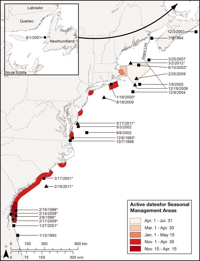
Fig. 2. Eubalaena glacialis. Locations and dates where all
discovery rates. For right whales, there were no
North Atlantic right whales killed by ships were found be-
fore and after Seasonal Management Areas (SMAs) were es- apparent differences for (1) ship-struck carcasses
tablished on 8 December 2008. *: carcass found in or within found > 45 nmi from active SMAs (p = 0.99) or (2) car-
45 nmi (83 km) of SMA boundaries during active time casses attributed to unknown causes that might have
frames; J: carcass locations during pre-rule years, 1990 to included ship strikes either in or near active SMAs
2008; M: carcass locations during post-rule years, 9 Decem-
ber 2008 through 8 December 2013
(p = 0.92) or beyond 45 nmi of the nearest active SMA
(p = 0.87). For humpback whales, there was no signif-
icant difference in discovery rates for ship-struck car-
and 10 December 1997), 2.9 yr (i.e. 1090 d between casses either within or near active SMAs (p = 0.68) or
10 December 1997 and 4 December 2000), and 2.8 yr beyond 45 nmi of the nearest active SMAs (p = 0.85).
(i.e. 1045 d between 8 February 2002 and 19 Decem-
ber 2004). During the 2.5 yr (912 d) post-rule period,
no ship-struck humpback whales were found inside DISCUSSION
active SMAs, but 2 were within 45 nmi of active
SMAs, giving a post-rule discovery rate of 0.80 Right whales
humpback whale carcasses yr−1.
From our bootstrap resampling analysis, the upper Results of this study indicate that the locations and
95% confidence interval around the annual pre-rule time frames of SMAs were well-chosen to protect
mean number of right whale ship-strike deaths in or North Atlantic right whales from ship strikes. During
near SMAs (0.72 carcasses yr−1) was 0.2 to 2.0 (Fig. 5). the 18 yr before SMAs were implemented, 87% (13
As of 5.0 yr after the rule’s adoption, the post-rule of 15) of all right whales known to have been killed
annual mean number of ship-strike deaths in or near by ships in US waters were found inside or within
SMAs was 0. The probability of a 5 yr post-rule car- 45 nmi of SMAs during later SMA effective dates.
cass discovery rate of 0 is significantly lower (p = Indeed, most of those carcasses (i.e. 12 of 15 or 80%)
0.031) than the pre-rule mean. An additional boot- were inside or within 6 nmi of SMA boundaries. It
strap resampling analysis was conducted to estimate therefore appears that most right whales killed by
the probabilities of finding 0, ≤1, or ≤2 carcasses in ships before December 2008 were found in or near140 Endang Species Res 23: 133–147, 2014
Table 3. Eubalaena glacialis. Date and distance from Seasonal Management Areas (SMAs) of all North Atlantic right whale
carcasses attributed to unknown causes, possibly including ship strikes, along the US East Coast: 1 January 1990 to 8 Decem-
ber 2013, before (pre-rule) and after (post-rule) the SMA implementation on 8 December 2008. Decomposition (Decomp.)
codes — 1: alive; 2: fresh; 3: moderate decomposition; 4: advanced decomposition; Unk: unknown condition; NC: North
Carolina; GA: Georgia
Date (mm/dd/yy) Nearest SMA Inside SMA Inside SMA Distance from SMA Decomp.
dates? boundary? (nmi/km) code
Pre-rule
01/15/93 Calving grounds SMA Yes No 62/115 Unk
12/06/93a Chesapeake Bay SMA Yes No 1.2/2.2 Unk
02/08/96a Calving grounds SMA Yes Yes 0 4
02/19/96a Calving grounds SMA Yes Yes 0 3
10/07/98 Chesapeake Bay SMA No No 8.5/15.7 4
01/19/00a Block Island Sound SMA Yes Yes 0 Unk
01/27/01a Calving grounds SMA Yes No 15/28 Unk
03/17/01a NC-GA Coast SMA Yes No 3/5.6 4
06/10/02a Great South Channel SMA Yes Yes 0 4
09/03/02 Chesapeake Bay SMA No No 38/70.3 3
09/06/02 Chesapeake Bay SMA No No 65/120.3 4
12/09/04 Great South Channel SMA No No 38/70.3 Unk
01/09/05 Great South Channel SMA No No 21/38.9 4
02/14/08a Calving grounds SMA Yes Yes 0 4
Post-rule
02/17/09a Calving grounds SMA Yes Yes 0 3
02/25/09 Great South Channel SMA No Yes 0 3
08/18/09 New York Harbor SMA No No 44/81.5 4
12/19/09 Great South Channel SMA No No 6.1/11.3 2
02/19/11a NC-GA SMA Yes No 34/63.0 4
03/17/11a Delaware Bay SMA Yes No 40/74.1 3
03/02/12a Race Point SMA Yes No 24/44.5 3
a
Carcass found in or within 45 nmi (83 km) of SMA boundaries during active time frames
areas where SMAs were later established and also tiveness holds up over time. The recommended
during their eventual effective dates. routing changes off Boston, the new recommended
The results also suggest that SMAs have effectively routes in Cape Cod Bay and the southeastern US
reduced the number of whale deaths due to ships. calving grounds, and new ATBA also may have
Average annual discovery rates of ship-struck right contributed to the apparent reduction in right
whale carcasses in or near active SMAs declined sig- whale ship-strike deaths by directing traffic
nificantly from 0.72 to 0 carcasses yr−1 for at least the through habitats used somewhat less frequently by
first 5.0 yr after the rule went into effect. This meas- whales. For example, a 58% reduction in collision
ure of reduction is likely to be conservative given risks was predicted by shifting a segment of the
that estimates of the size of the North Atlantic right Boston shipping lanes (www.scimaps.org/maps/
whale population increased over the study period map/realigning_the_bosto_88/), and Fonnesbeck et
from about 295 whales in 1992 (Knowlton et al. 1994) al. (2008) predicted as much as a 44% reduction
to about 500 whales in 2013, with the addition of with new shipping lanes through the calving
about 80 whales from 2008 through 2013 (New Eng- grounds. However, the new routes must still cross
land Aquarium unpubl. data). Thus, the number of key right whale habitats, and no useful routing
whales available to be struck has increased in post- alternatives exist for mid-Atlantic ports along the
rule years. In addition, the 5.0 yr post-rule period right whale’s coastal migratory corridor, where
during which no ship-struck right whales carcass nearly half of all vessel-related right whale deaths
were discovered in or near any acitve SMAs is almost have been discovered. Thus, although there should
twice as long as the longest gap (i.e. 2.8 yr) between be some uncertain amount of risk reduction from
such discoveries during the pre-rule period. new routes now in place, we believe speed restric-
These results are encouraging, but require a tions are likely to be a more important factor in
longer time period to confirm if the apparent effec- reducing collision risks along the US East Coast.Laist et al.: Speed limits for right whales 141
high ship traffic and limited winter survey effort. The
second possibility has some support from past experi-
ence. During a 4 yr period between 1993 and 1996,
the annual discovery rate for right whale carcasses
attributed to unknown causes in or near later active
SMAs was 0.75 carcasses yr−1 (3 of 4 carcasses),
which approaches the post-rule rate of 0.80 (Table 3).
Other studies have found little or no evidence that
recent management measures have reduced vessel-
related right whale deaths along the US East Coast.
Analyses to date, however, have been too broad in
scope, or involved time frames ill-suited for assessing
effectiveness of the SMA network. For example, van
der Hoop et al. (2013) found no noticeable reduction
in large whale vessel- and entanglement-related
deaths from 2003 through 2009 (when a number of
management actions were implemented, including
outreach efforts to advise mariners of collision risks),
compared to earlier years. That study, however, was
not designed to assess the effectiveness of site-spe-
cific measures or specifically of SMA vessel-speed
restrictions. In particular, it included only 1 yr of data
after SMAs were established.
Similarly, Pace (2011) found no significant reduc-
tion in ship-collision deaths after the rule went into
effect. However, his analysis was based on only 2 yr
Fig. 3. Eubalaena glacialis. Locations and dates where all of post-rule data, measured intervals between colli-
North Atlantic right whales killed by unknown causes, pos-
sibly including ship strikes, were found before and after sions involving all species of large whales (i.e. hump-
Seasonal Management Areas (SMAs) were established on 8 back, right, fin, and sei whales), considered all types
December 2008. *: carcass found in or within 45 nmi (83 km) of vessels (including those < 65 ft in length that are
of SMA boundaries during active time frames; J: carcass not subject to regulation), and included all US and
locations during pre-rule years, 1990 to 2008; M: carcass lo-
cations during post-rule years, 9 December 2008 through
Canadian waters (including those not near SMAs).
8 December 2013 Furthermore, it did not distinguish between colli-
sions inside versus outside SMA time frames. In con-
We found no indication that SMAs have reduced trast, our analysis focuses on those collisions most
the number of right whale deaths attributed to un- likely to have occurred within SMA boundaries, dur-
known causes. The percentages of such deaths in or ing effective dates, on the species of greatest concern
near active SMAs in the pre-rule (57.1%, 8 of 14) and (i.e. right whales), and on the vessels most likely to
post-rule (57.1%, 4 of 7) periods were identical, and have been subject to management (i.e. all carcasses
the average annual carcass recovery rate actually in- considered in this analysis had large wounds or con-
creased from 0.44 to 0.80 carcasses yr−1 during the tusions indicative of collisions with vessels that likely
post-rule period. The most parsimonious interpreta- were > 65 feet long). Therefore, we believe this ana-
tions for the increase in deaths due to unknown lysis provides a more direct and useful measure of
causes are that (1) all or most right whale deaths that the rule’s effectiveness for right whales.
may have been attributed to unknown causes but
were actually due to ship strikes occurred > 45 nmi
from the nearest active SMA, (2) most right whale Humpback whales
deaths attributed to unknown causes were not caused
by ship collisions, and the increase reflects stochastic Our results suggest that SMAs have not provided a
variability. As indicated below, an example of the first significant benefit for humpback whales. Whereas
possibility may be the cluster of 4 carcasses attributed 87% of all ship-struck right whales were found in or
to unknown causes found in the southern Great near SMAs during effective dates in the pre-rule
South Channel area in winter. This is an area with period, less than half (46%) of all such humpback142 Endang Species Res 23: 133–147, 2014
Table 4. Megaptera novaeangliae. Date and distance from Seasonal Management Areas (SMAs) of all humpback whale car-
casses attributed to ship strikes along the US East Coast: 1 January 1990 to 8 June 2011, before (pre-rule) and after (post-rule)
the SMA implementation on 8 December 2008. Decomposition (Decomp.) codes — 1: alive; 2: fresh; 3: moderate decomposition;
4: advanced decomposition; Unk: unknown condition; NC: North Carolina; GA: Georgia
Date (mm/dd/yy) Nearest SMA Inside SMA Inside SMA Distance from SMA Decomp.
dates? boundary? (nmi/km) code
Pre-rule
11/08/91a New York Harbor SMA Yes No 22.6/41.9 Unk
02/14/92a Chesapeake Bay SMA Yes Yes 0 3
04/16/92a Delaware Bay SMA Yes No 22.7/42.0 4
06/04/95 Chesapeake Bay SMA No No 0.1/0.2 3
05/09/96 Delaware Bay SMA No No 0.5/0.9 3
11/03/96a Chesapeake Bay SMA Yes No 42.9/79.5 3
12/10/97a Morehead City SMA Yes Yes 0 3
12/04/00a Morehead City SMA Yes Yes 0
01/25/01 Chesapeake Bay SMA Yes No 51.6/95.6 2
04/08/01a NC-GA Coast SMA Yes Yes 0 2
07/29/01 New York Harbor SMA No No 6.8/12.6 3
08/18/01 Delaware Bay SMA No No 22.5/41.7 2
10/01/01 Cape Cod Bay SMA No Yes 0 3
02/08/02a Chesapeake Bay SMA Yes No 4.8/8.9 Unk
05/30/02 Race Point SMA No No 51.7/95.7 3
08/01/02 New York Harbor SMA No No 0 4
06/06/03 Chesapeake Bay SMA No No 4.6/8.5 2-3
12/19/04a Delaware Bay SMA Yes Yes 0 3
01/09/06a NC-GA Coast SMA Yes Yes 0 3
03/17/06a Chesapeake Bay SMA Yes No 1.5/2.8 3
09/27/06 Delaware Bay SMA No Yes 0 4
10/15/06 Delaware Bay SMA No No 6.2/11.5 4
05/10/07 Chesapeake Bay SMA No No 21.6/40.0 4
05/13/07 Race Point SMA No No 9.2/17.0 4
06/24/07 Race Point SMA No Yes 0 3
11/04/08a Delaware Bay SMA Yes No 20.1/37.2 2
Post-rule
07/27/09 New York Harbor SMA No Yes 0 3
03/13/10a Delaware Bay SMA Yes No 12.8/23.7 3
06/10/10 New York Harbor SMA No No 0.1/0.2 3
07/04/10 Delaware Bay SMA No No 12.0/22.2 4
03/07/11a Morehead City SMA Yes No 15/27.8 1
05/28/11 New York Harbor No No 23.9/44.3 4
a
Carcass found in or within 45 nmi (83 km) of SMA boundaries during active time frames
whales were in or near those areas during active Uncertainties in the time and location of collisions
dates. However, it is notable that 12 of the other 15
pre-rule humpback whales killed by ships were In addition to constraints due to the small sample
found in or near SMA boundaries, but were outside size of ship-struck carcasses on the statistical power
of SMA active dates (Table 5). This pattern persisted of our analyses, 2 other limitations led to uncertain-
in post-rule years when all 6 of the ship-struck hump- ties: (1) the precise dates of collisions and (2) the pre-
back whale carcasses were found in or near SMA cise locations of collisions relative to SMA dates and
boundaries, but only 2 were within their active dates. boundaries. Because the length of time between a
Thus, it would seem that SMAs could be beneficial collision and the discovery of collision-related car-
for humpback whales if their effective dates were casses is unknown and variable, there is some uncer-
expanded to better reflect the timing of their sea- tainty about whether those whales were struck dur-
sonal occurrence in SMA boundaries. The occur- ing SMA active dates. In most cases, we believe
rence of humpback whale collisions outside of active carcass discovery dates can be related with reason-
dates is understandable given that SMA time frames able accuracy to active SMA dates. All ship-struck
were developed specifically for right whale protection. right whale carcasses found in or near SMAs duringLaist et al.: Speed limits for right whales 143
0.2
0.15
Probability
0.1
0.05
0
0 1 2 3 4 5 6 7 8 9 10
Number of right whale carcasses found in or near SMAs
Fig. 5. Eubalaena glacialis. Probabilities of finding 0 to 10
right whale carcasses in or near Seasonal Management Ar-
eas (SMAs) over the 5 yr post-rule period (8 December 2008
to 8 December 2013) based on bootstrap resampling of dis-
covery records during the 18 yr pre-rule period (8 December
1990 to 7 December 2008). Dark gray bars show probabili-
ties of 5 yr totals assuming whales could be found in any
year during the 5 yr period; light gray bars show probabili-
ties assuming no whales were found in years 1 to 5 and 0, ≤1,
or ≤2 whales were found in Year 6; gray dashed line shows
the annual mean pre-rule discovery rate of 0.72 (equivalent
to 3.6 carcasses over 5 yr)
Fig. 4. Megaptera novaeangliae. Locations and dates where
end dates of the nearest active SMA (i.e. a humpback
all humpback whales killed by ships were found before and
after Seasonal Management Areas (SMAs) were established whale with no information on its decomposition state
on 8 December 2008. *: carcass found in or within 45 nmi was found 8 d after the start of the nearest SMA
(83 km) of SMA boundaries during active time frames; J: 22.6 nmi away). Thus, it seems reasonable to believe
carcass locations during pre-rule years, 1990 to 2008; M: car- that most, if not all, carcasses considered to have
cass locations during post-rule years, 9 December 2008
through 8 June 2013
been struck in or near SMAs during active SMA
dates were in fact struck during those periods.
Far less clear is whether ship-strike victims found
pre-rule years with information on their decomposi- in or near SMA boundaries were in fact struck within
tion state (i.e. 11 of 13) were moderately decomposed SMA boundaries. Complicating factors include the
(Code 3) or fresher. Similarly, all but 1 ship-struck possibility of whales swimming some distance after
humpback whale found in or near SMAs with infor- being struck and before they die and drift an addi-
mation on decomposition condition (7 of 8) were tional distance from collision locations. Because of
Code 3 or fresher. As noted above, right whale car- those possibilities, some dead whales discovered out-
casses can degrade to a Code 3 condition within a side SMA boundaries may have been struck inside
week or less. Because most right whale carcasses SMA boundaries and vice versa. In general, it seems
attributed to ship strikes along the US East Coast unlikely that lethally struck whales would swim long
have involved massive injuries, such as fractured distances after being hit. Even if whales do not die
skulls or vertebrae, severed tail stocks, and long, instantly or within a few hours, massive injuries typi-
deep propeller wounds (Moore et al. 2004), it seems cal of collision deaths are likely to leave them mori-
reasonable to assume that most victims die within a bund or highly immobile. Transport of moribund or
day or 2, if not hours, of being hit. By adding those dead whales by wind and currents is more difficult to
pre- and post-mortem times together, it seems likely gauge. As noted above, resighted right whale car-
that most ship-collision deaths reported in this study casses drifted an average of 7 nmi d−1, and 1 drifted
occurred no more than about 7 to 8 d before the dis- 112 nmi (204 km) in 8 d, for an average of 14 nmi
covery dates. Only 1 ship-struck whale found in or (26 km) d−1. Thus, it is possible that some ship-struck
near an SMA was found < 9 d after the beginning or carcasses could have drifted into SMAs from adja-144 Endang Species Res 23: 133–147, 2014
cent areas. Indeed, given that 5 of 8 right whale car- dor set as 20 nmi arcs around port entrances, it is pos-
casses found inside SMA boundaries during pre-rule sible that vessels entering or leaving port may hit
years were moderately decomposed, it would seem whales in the offshore third of the species’ presumed
likely that at least some drifted 45 nmi before being migratory corridor (i.e. 20 to 30 nmi from shore),
found, which could have put them outside but near where speed limits do not apply. Those carcasses
SMA boundaries. may drift into SMAs and be assumed incorrectly to
A detailed analysis of carcass drift for ship-strike have been struck by ships complying with speed
victims found in the past was beyond the scope of this restrictions inside an SMA. Also, because carcass
study. To improve understanding of where ship- detection and retrieval becomes more difficult as dis-
strike victims are actually struck relative to SMA tance from shore increases, whales struck and killed
boundaries in the future, we recommend conducting in this offshore zone that do not drift towards shore
a retrospective drift analysis as a routine part of may be underestimated.
investigations for future ship-struck right whale car- To more rigorously protect right whales and reduce
casses. Where possible, estimates should be made uncertainty about whether ship-strike victims are
during necropsies of the time between death and the struck just beyond SMA boundaries where speed
discovery of all carcasses attributed to ship strikes. restrictions do not apply, we recommend that (1) the
That time span should then be used to trace the pos- boundaries of the SMAs along the species’ migratory
sible drift path back to a predicted location at the corridor be extended to 30 nmi from shore, as initially
time of death based on prevailing winds and currents proposed by the NMFS; (2) the configuration of
over that period. SMAs be modified from an arc to a rectangle, with
Despite uncertainty about precisely where past boundaries extending perpendicular from the points
ship-strike victims were struck, the pattern of carcass where current SMA perimeters intersect with land
recovery shown in Fig. 2 strongly suggests that out to 30 nmi offshore, to cover a greater portion of
nearly 90% of all right whale deaths attributed to vessel tracks across core migratory areas; and (3)
ship strikes in US waters since 8 December 1990 and SMAs be made effective indefinitely, with a view
before the rule became effective were struck in or towards retaining them unless further analyses
near SMAs during the periods in which these were in demonstrate they are ineffective or should be modi-
effect. The possibility that some of those whales were fied. Changing SMA boundaries along the migratory
struck in waters adjacent to SMA boundaries under- corridor from arcs to rectangles that extend 20 (or 30)
scores the importance of expanding SMA boundaries nmi from shore would increase their size by about
along the species’ migratory corridor (i.e. from Geor- 25%. This change would increase the probability
gia to New York) to the 30 nmi limit originally pro- that ships entering or leaving port along routes that
posed by the NMFS based on its past assessment of are not perpendicular to the coast would travel at
the width of the right whale migratory corridor and speeds safe for whales when transiting areas where
relevant new information. In addition, we recom- migrating whales are most likely to be encountered.
mend that further studies be undertaken to better It is also interesting that several right whale deaths
define the distances from shore that most right due to unknown causes, possibly including ship
whales travel during their migrations in spring and strikes, were found offshore at distances and/or at
fall between Georgia and New York. times of the year when retrieval was more difficult. In
this regard, 4 of 15 right whale deaths of unknown
cause were clustered in or near the southern tip of
SMA boundaries the Great South Channel SMA from December
through February, when that SMA was not in effect
With half of all known right whale deaths in US (Fig. 2). Those deaths, which occurred at a time of
waters since 1990 due to ship strikes found along the year with poor weather conditions and where carcass
species’ migratory corridor — which is thought to retrieval is very difficult, lie near an area where sev-
extend to approximately 30 nmi from shore (Schick eral heavily used vessel traffic corridors intersect
2009, Keller et al. 2012) — failure to include waters (Ward-Geiger et al. 2005). That area may, therefore,
between 20 and 30 nmi in SMA boundaries leaves a be an additional site where ship collision risks are
potentially significant gap in protection of right high and where the designation of an SMA should be
whales from ship collisions. Its lack of inclusion also considered. In general, carcasses are less likely to be
complicates evaluations of SMA effectiveness. With found farther offshore, because of reduced survey
current SMA boundaries along the migratory corri- effort. We do not, however, believe this bias wouldLaist et al.: Speed limits for right whales 145
alter our conclusions, because, with the exception of nated shipping lanes south of the Great South Chan-
waters in the Gulf of Maine, right whale occurrence nel SMA, where 4 unretrieved right whale carcasses
is believed to decrease in waters beyond 30 nmi from possibly struck by ships were found in the months of
shore. In addition, those areas were not subject to December through February; and (3) extending the
regulation either before or after the rules went into dates of SMAs, to better cover times when humpback
effect, and thus right whale occurrence in or near whales are likely to occur in SMA boundaries. Given
SMAs should not differ in either period. The whales’ the apparent effectiveness of reduced speed limits
distance from shore may also make it less likely they and experience indicating a lack of compliance with
would drift into SMAs. voluntary requests to use reduced speeds (McKenna
et al. 2012, Silber et al. 2012b), we also recommend
that speed limits in short-term DMA zones be made
CONCLUSIONS mandatory, rather than voluntary, to protect periodic
right whale aggregations found outside of active
Analyses of the locations where ship-struck whale SMAs. Our study provides encouraging evidence
carcasses are found provide useful methods for eval- that 10 knot speed restrictions are effective for reduc-
uating the biological effectiveness of SMAs estab- ing vessel-related right whale deaths. Such restric-
lished to protect North Atlantic right whales. The tions should be considered as an option for mitigating
overall pattern of carcass discovery locations shown vessel strikes of large whales in other parts of the
in Fig. 2 strongly suggests that a large majority of world where this problem is considered significant.
ship-collision victims found in pre-rule years were
struck by ships entering and leaving ports where the Acknowledgements. We thank Mendy Garron and Allison
10 SMAs were later designated and also on dates Henry of the National Marine Fisheries Service for search-
that coincided with periods in which the later SMAs ing the National Marine Mammal Strandings database. We
were in effect. The increased waiting time between also thank Brooke Wikgren of the New England Aquarium
for plotting those records on a study area map, calculating
discovery of ship collisions in or near active SMAs distances of carcasses from SMA boundaries, and preparing
after the December 2008 implementation (i.e. 5.0 yr the figures in this paper. Peter Thomas, Michael Tlusty, and
as of the date of this analysis) also suggests that the 4 anonymous reviewers also provided constructive com-
seasonal 10 knot speed limit has been effective, ments on various drafts for which we are very grateful. We
also acknowledge and thank all the necropsy team leaders
although additional time is needed to confirm long-
and stranding program participants whose hard work was
term trends. When the rule was adopted, it was essential in creating this valuable database.
thought it would also benefit humpback whales, but
there is no evidence from this analysis that this has
been true. Numerous collisions involving humpback LITERATURE CITED
whales were found within or near SMA boundaries,
➤ Asaro MJ (2012) Geospatial analysis of management areas
but most were not during active SMA dates. implemented for protection of the North Atlantic right
Based on these results, speed restrictions and the whale along the northern Atlantic coast of the United
existing SMAs are tools that should be kept in place States. Mar Policy 36:915−921
Clyne H (1999) Computer simulations of interactions
indefinitely. Dredged channels passing through
between the North Atlantic right whale (Eubalaena
SMAs should not be exempted from restrictions, as glacialis) and shipping. Masters thesis in Software Tech-
requested by petition, because whales must travel nology, Napier University, Edinburgh
across those channels and are at no less risk of being ➤ Conn PB, Silber GK (2013) Vessel speed restrictions reduce
risk of collision-related mortality for North Atlantic right
struck in those channels. The rules appear to have
whales. Ecosphere 4(4):Article 43
been effective and remain necessary to prevent ship- Efron B, Tibshirani RJ (1993) An introduction to the boot-
related right whale deaths. However, to better cover strap. Chapman & Hall, New York, NY
areas where right whales are at greatest risk, SMA ➤ Fonnesbeck CJ, Garrison LP, Ward-Geiger LI, Baumstark
boundaries along the right whale migratory corridor RD (2008) Bayesian hierarchical model for evaluating the
risk of vessel strikes on North Atlantic right whales in the
should be extended from 20 to 30 nmi from shore, as SE United States. Endang Species Res 6:87−94
originally proposed by the NMFS. In addition, con- ➤ Gende SM, Hendrix AN, Harris KR, Eichenlaub B, Nielson J,
sideration should be given to: (1) changing the con- Pyare S (2011) A Bayesian approach for understanding
figuration of SMA boundaries off ports in the role of ship speed in whale−ship encounters. Ecol
Appl 21:2232−2240
mid-Atlantic states from arcs to rectangles, to better
Geraci JR, Lounsbury VJ (2005) Marine mammals ashore: a
protect whales migrating farther offshore; (2) estab- field guide for strandings, 2nd edn. National Aquarium
lishing a new winter SMA along a segment of desig- in Baltimore, Baltimore, MD146 Endang Species Res 23: 133–147, 2014
➤ Keller CA, Garrison L, Baumstark R, Ward-Geiger LI, Hines 71:36299−36313. Available at www.nmfs.noaa.gov/pr/
E (2012) Application of a habitat model to define calving pdfs/fr/fr71-36299.pdf (accessed 26 February 2013)
habitat of the North Atlantic right whale in the southeast- National Marine Fisheries Service (2008a) Final rule to
ern United States. Endang Species Res 18:73−87 implement speed restrictions to reduce the threat of ship
Knowlton AR, Kraus SD (2001) Mortality and serious injury collisions with North Atlantic right whales. Fed Regist
of northern right whales (Eubalaena glacialis) in the 73:60173−60191. Available at www.nmfs.noaa.gov/pr/
western North Atlantic Ocean. J Cetacean Res Manag pdfs/fr/fr73-60173.pdf (accessed 10 October 2013)
2(Spec Issue):193−208 National Marine Fisheries Service (2008b) Final envi-
Knowlton AR, Kraus SD, Kenney RD (1994) Reproduction in ronmental impact statement to implement the opera-
North Atlantic right whales (Eubalaena glacialis). Can J tional measures of the North Atlantic right whale ship-
Zool 1297−1305 strike reduction strategy. Office of Protected Species,
Knowlton AR, Korsmeyer FT, Kerwin JE, Wu HY, Haynes B National Marine Fisheries Service, Silver Spring, MD.
(1995) The hydrodynamic effects of large vessels on right Available at www.nmfs.noaa.gov/pr/pdfs/shipstrike/feis.
whales. Contract No. 40ANFF400534, final report to the pdf (accessed 10 October 2013)
National Marine Fisheries Service, Northeast Fisheries National Marine Fisheries Service (2013) Final rule to elimi-
Science Center, Woods Hole, MA nate the sunset provision of the final rule implementing
➤ Knowlton AR, Hamilton PK, Marx MK, Pettis HM, Kraus SD vessel speed restrictions to reduce the threat of ship col-
(2012) Monitoring North Atlantic right whale Eubalaena lisions with North Atlantic right whales. Fed Regist 78:
glacialis entanglement rates: a 30 yr retrospective. Mar 73726−73736. Available at www.gpo.gov/fdsys/pkg/FR-
Ecol Prog Ser 466:293−302 2013-12-09/pdf/2013-29355.pdf (accessed 20 December
➤ Kraus SD, Brown MW, Caswell H, Clark CW and others 2013)
(2005) North Atlantic right whales in crisis. Science 309: Pace RM III (2011) Frequency of whale and vessel collisions
561−562 on the US eastern seaboard: ten years prior and two
➤ Lagueux KM, Zani MA, Knowlton AR, Kraus SD (2011) years post ship-strike rule. NOAA/NEFSC Reference
Response by vessel operators to protection measures for Document 11-15, Woods Hole, MA. Available at http://
right whales Eubalaena glacialis in the southeast US nefsc.noaa.gov/publications/crd/crd1115/ (accessed 26
calving ground. Endang Species Res 14:69−77 February 2013)
➤ Laist DW, Knowlton AR, Mead JG, Collet AS, Podesta M Reeves RR, Smith TD, Josephson EA (2007) Near-annihila-
(2001) Collisions between ships and whales. Mar Mamm tion of a species: right whaling in the North Atlantic. In:
Sci 17:35−75 Kraus SD, Rolland RM (eds) The urban whale: North
Marine Mammal Commission (2008) The biological viability Atlantic right whales at the crossroads. Harvard Univer-
of the most endangered marine mammals and the cost- sity Press, Cambridge, MA p 39–74
effectiveness of protection programs: a report to Con- Russell BA, Knowlton AR, Zoodsma B (2001) Recommended
gress from the Marine Mammal Commission. Available measures to reduce ship strikes of North Atlantic right
at http://mmc.gov/reports/publications/welcome.shtml whales. Report submitted to the National Marine Fish-
(accessed 26 February 2013) eries Service in partial fulfillment of NMFS Contract
Marine Mammal Commission (2013) Annual Report to 40EMF9000223. National Marine Fisheries Service, Office
Congress 2010−2011 Marine Mammal Commission. of Protected Resources, Silver Spring, MD. Available at
Available at http://mmc.gov/reports/annual/welcome. www.nero.noaa.gov/shipstrike/subinfo/finalreport.pdf
shtml (accessed 1 Jannuary 2014) (accessed 26 February 2013)
➤ McKenna MF, Katz SL, Condit C, Walbridge S (2012) Re- ➤ Schick RS (2009) Striking the right balance in right whale
sponse of commercial ships to a voluntary speed reduc- conservation. Can J Fish Aquat Sci 66:1399−1403
tion measure: Are voluntary strategies adequate for mit- Silber GK, Bettridge S (2009) Report of a workshop on
igating ship-strike risk? Coast Manage 40:634−650 assessing the effectiveness of the right whale ship-strike
Moore MJ, Knowlton AR, Kraus SD, McLellan WA, Bonde reduction rule. NOAA Tech Memo NMFS-OPR-42,
RK (2004) Morphometry, gross morphology and available Office of Protected Resources, National Marine Fisheries
histopathology in North Atlantic right whale (Eubalaena Service, Silver Spring, MD. Available at www.nmfs.
glacialis) mortalities (1970−2002). J Cetacean Res Manag noaa.gov/pr/pdfs/shipstrike/technology_workshop
6:199−214 _report.pdf (accessed 26 February 2013)
Mueller M, Ortega-Ortiz JG, Zoodsma B (2011) Vessel com- Silber GK, Bettridge S (2010) Vessel operations in right
pliance with right whale protection measures in the whale protection areas in 2009. U.S. Department of
southeast U.S. seasonal management area: trends from 5 Commerce, NOAA Tech Memo NMFS-OPR-44, Office of
years of monitoring. In: Abstracts of the 19th Biennial Protected Resources, National Marine Fisheries Service,
Conf Biol Marine Mammals. Society for Marine Mam- Silver Spring, MD. Available at www.nmfs.noaa.gov/pr/
malogy, Lawrence, KS, p 213 pdfs/shipstrike/opr44.pdf (accessed 26 February 2013)
National Marine Fisheries Service (2005) Recovery plan Silber GK, Bettridge S (2012) An assessment of the final rule
for the North Atlantic right whale Eubalaena glacia- to implement vessel speed restrictions to reduce the
lis revision. U.S. Department of Commerce, National threat of vessel collisions with North Atlantic right
Oceanic and Atmospheric Administration, Office of whales. NOAA Tech Memo NMFS-OPR-48, Office of
Protected Species, Silver Spring,MD. Available at www. Protected Resources, National Marine Fisheries Service,
nmfs.noaa.gov/pr/recovery/plans.htm (accessed 10 Oc- Silver Spring, MD. Available at www.nmfs.noaa.gov/
tober 2013) pr/pdfs/shipstrike/assessment_nmfsopr48.pdf (accessed
National Marine Fisheries Service (2006) Proposed rule to 26 February 2013)
implement speed restrictions to reduce the threat of ship ➤ Silber GK, Slutsky J, Bettridge S (2010) Hydrodynamics of a
collisions with North Atlantic right whales. Fed Regist ship/whale collision. J Exp Mar Biol Ecol 391:10−19You can also read