BIRCHINGTON NEIGHBOURHOOD PLAN CHARACTER ASSESSMENT - Version FINAL
←
→
Page content transcription
If your browser does not render page correctly, please read the page content below
BIRCHINGTON
 NEIGHBOURHOOD PLAN
CHARACTER ASSESSMENT

             Version FINAL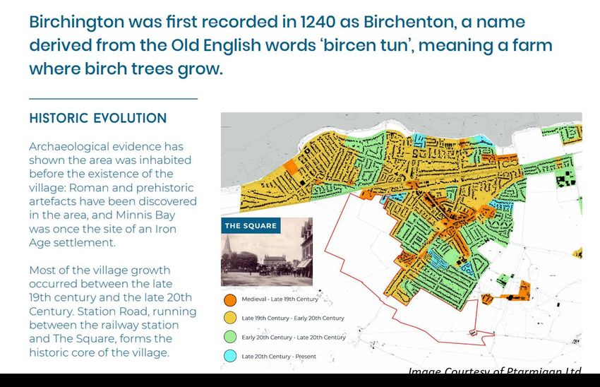
Document Control

VERSION    DATE                      CHANGE                       REVIEWER
   1      01/10/20   Draft initial document                   Rod Giddins
   2      21/10/20   Review – add additional sections         Nick Blankley
          14/11/20   Review and strengthened content          Rod Giddins / Nick
   3
                                                              Blankley
          28/11/20   Identify key policy implications         Rod Giddins / Nick
   4
                                                              Blankley
          05/12/20   Add key Points summaries                 Rod Giddins / Nick
   5
                                                              Blankley
   6      04/01/21   Add images and reformat                  Nick Blankley
   7      11/01/21   Minor text change and picture captions   Core Group
 FINAL    12/01/21                                            Core Group
Contents

1.    Introduction and Purpose .......................................................................................... 1
2.    Birchington Approaches ............................................................................................. 2
3.    The Built Environment ............................................................................................... 6
4.    The Coastal Scene .................................................................................................... 11
5.    Birchington Landscape Character ............................................................................. 14
6.    Legislation ............................................................................................................... 18
7.    Sensitivities and Concerns........................................................................................ 20
8.    Conclusions and Recommendations ......................................................................... 22
9.    Recommendations to inform policy making in the Neighbourhood Plan ................... 23
10.      Glossary of terms ................................................................................................. 24
1. Introduction and Purpose
The purpose of this document is to describe the character of Birchington, highlighting key
features of the natural and built environments, landscapes and seascapes and the role they
play in making the village the place it is today. It provides a summary of planning legislation
that protects our most valuable historic and natural assets and concludes with a series of
recommended objectives to underpin draft policies in the Birchington Neighbourhood Plan.
Content is informed and shaped by:
   • The National Policy & Planning Framework
   • Thanet District Local Plan 2031 and supporting evidence
   • Local feedback gathered through consultation and public meetings
   • Results of village surveys
   • Research and evidence provided by Birchington Heritage Society
   • Information and guidance published by relevant organisations including Locality,
      Natural England and English Heritage
   • Research and evidence gathered by the authors

Chapter headings are:

   •   Birchington Approaches
   •   The Built Environment
   •   The Coastal Scene
   •   Landscape Character
   •   Special Characteristics
   •   Legislation
   •   Sensitivities and Concerns
   •   Conclusions and Recommendations

At the end of each chapter we have included references to other documents and district-
wide policies, where appropriate, and a set of guidelines to inform the Neighbourhood Plan.

                                         Page 1 of 24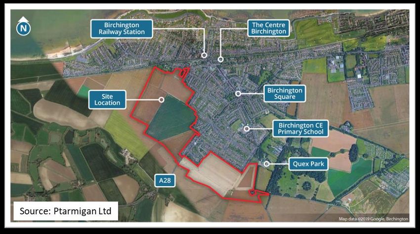
2. Birchington Approaches
Road, rail or pedestrian approaches to Birchington are characterised by long views, a sense
of openness, big spaces and connection with a natural environment which provides habitat
for a rich mix of ‘resident’ and migrating wildlife.

The village is situated at the north western       eye across the Wade Marshes to the coast
end of the urban area of Thanet District. It       and residential apartment blocks at the
is the first significant settlement on the Isle    edge of Birchington.
of Thanet when approaching from the                To the south, the harsh industrial and
west.                                              angular form of the buildings that form
                                                   Thanet Earth stand as a large, naked blot
                                                   on the landscape. The sparse, immature
                                                   ‘green screen’ fronting some of the
                                                   buildings offers little distraction or
                                                   camouflage for the traveller or walker. A
                                                   major source of light pollution, this stands

Distant views from the principal trunk
roads (the A299 “Thanet Way” and A28
Canterbury Road) and from the main
London to Margate railway line, lead the

                                           Page 2 of 24
as a poor example of harmony between            Viking Trail pedestrian and cycle coast
the natural and built environments.             route, a scan of the horizon reveals open
                                                sea and shingle beach to the north, the
Closer to the village the A28 road dips to
                                                crescent of golden beaches at Minnis Bay
the semi-wooded valley at Brooksend
                                                ahead, the first sign of urban development
before rising to a chalk escarpment and
                                                and, to the south, views across open fields
levelling out, providing long views north
                                                with the All Saints church spire prominent
towards the coast, east to the landmark All
                                                on the skyline.
Saints church spire and village outskirts,
south across undulating farmland towards
Quex Park and the village of Acol.
The road narrows upon entry to the built-
up area before reaching the church and
The Square. Here the A28 joins Station
Road, the village’s main commercial hub.
South from The Square a narrow former
cart track (now Park Lane) leads to Quex
Park and Acol, whilst the main A28
continues eastwards to Westgate on Sea
and Margate.

                                                Users of the London mainline railway
                                                enjoy these views too, the broad open
                                                spaces and characteristic skies reinforcing
                                                the lifelong childhood feeling of
                                                adventure evoked by rail travel.

In the opposite direction, travelling west
from the village Square on the A28
towards Canterbury there are long views
towards St Nicholas at Wade, with the
parish church tower prominent on the
skyline. In addition, there are extensive
views along the coast to the landmark
Reculver Towers, Herne Bay pier remains
and the Isle of Sheppey as well as across
the Thames Estuary to the Essex coast.          Entering the village from the east (i.e.
Thanet Earth horticultural glasshouses are      Westgate on Sea and Margate) along the
prominent to the south of the village.          A28, school playing fields, hedgerows,
Approaching the village boundary at Plum        trees and Crispe Park provide a green
Pudding Farm from the west along the            corridor and green breaks in the urban
                                                area before reaching The Square.

                                        Page 3 of 24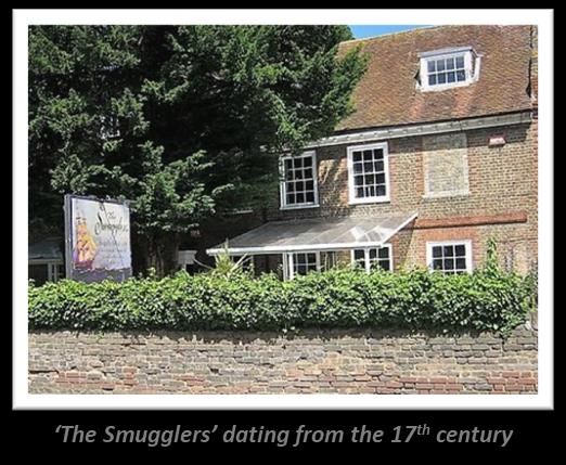
towards Manston and then Acol are
                                                  uplifting; to the north the open fields give
                                                  way to King Ethelbert School and the
                                                  beginnings of the Birchington urban area
                                                  before the boundary hedges and
                                                  woodland of Quex Park come into view.

                                                 Northwest off Shottendane Road, Park
                                                 Road runs between open fields and the
                                                 mature green boundary of Quex Park.
                                                 Behind the first houses to the west the
                                                 Memorial Recreation Ground provided
                                                 the venue for sports and recreation since
                                                 the ground was gifted to the village in
                                                 1924 by the Erlbach family as a memorial
On the secondary route from Westgate            to their three sons and all who fell in the
via Sea Road there are long views from          Great War.
Epple Bay across the Thames Estuary and
along the coast past Birchington to
Reculver and the Isle of Sheppey. The
sense of openness is reinforced by the
golf fairways and greens to the south.

                                                From the village of Acol, which sits in a
                                                valley to the south, passing a row of
                                                mature trees to the east the hedgerows

Looking back eastwards, Westgate Bay and
the skyline beyond the headland towards
Margate provide a delightful and
contrasting mix of seascape and urban
development.
Inland, approaching from the east along
Shottendane Road throughout the year
the open countryside provides a hint of the
changing seasons as the prime agricultural
land transforms from bare earth, to green
shoots, mature crops and ultimately to
bare earth again. The open views south

                                        Page 4 of 24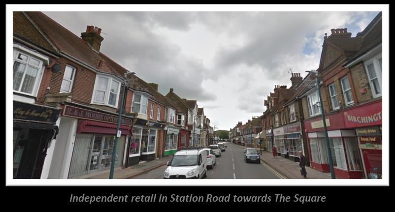
and trees on the boundaries of the Quex           mark the start of the built-up area at
Park estate along Shottendane and                 Brunswick Road. A couple of hundred
Manston Roads come into view together             yards further on Birchington Primary
with the white Waterloo Tower situated            School occupies a large area to the west
on the Quex estate. Ahead a green corridor        before the approaches to The Square.
of hedges and woodland along Park Lane

                                         Key Points

•   The approaches to Birchington are uplifting and an essential part of the village character,
    they should be nurtured and protected.
•   Any proposals for development at the edge of the existing urban settlement should
    include “soft” edges to shield buildings and ease the transition between the countryside
    and the urban area.
•   Wherever possible, uninterrupted views and vistas looking into and out of the village in all
    directions should be preserved.
•   Views and vistas along the coast in both directions should be protected.
•   New development should, wherever possible, incorporate ‘green wedges’ and ‘green
    lanes’ to prevent massing of buildings, to provide new views and vistas and new routes
    for informal recreation.
•   Trees and hedgerows that provide habitat for wildlife and enhance the open landscape
    should be protected.
•   The mature woodland and hedges that screen Quex House and commercial enterprises in
    Quex Park should be retained and, wherever possible, enhanced.
•   The operation of Thanet Earth horticultural glasshouses should be subject to review to
    ensure that buildings are adequately screened in keeping with the landscape and that light
    pollution is significantly reduced.
•   Refer to Local Plan policies E12, SP26 and SP27 for specific planning requirements.

                                         Page 5 of 24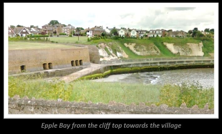
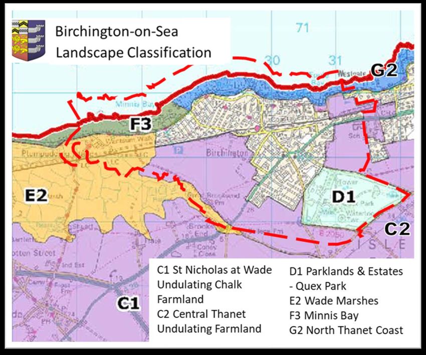
3. The Built Environment

The map above shows the development of
the village from medieval times to the 21st
century with the land edged red to the
south-west of the village allocated for
housing development in the Local Plan
2020. The core of the village around The
Square is designated as a Conservation
Area and contains some of Birchington’s
oldest buildings including the Grade II* All
Saints Church.

                                                  There are medieval and Tudor buildings
                                                  still standing in Birchington. Among the
                                                  earliest of these is Old Bay Cottage in
                                                  Minnis Road, dating from about 1450,
                                                  Church Cottages on the south side of
                                                  Canterbury Road, west of the village
                                                  centre, dating from about 1500 to 1550;
                                                  opposite is Street Farm Cottages,
                                                  extended in the 19th century.
                                                  In the 17th century the new Low Countries

                                         Page 6 of 24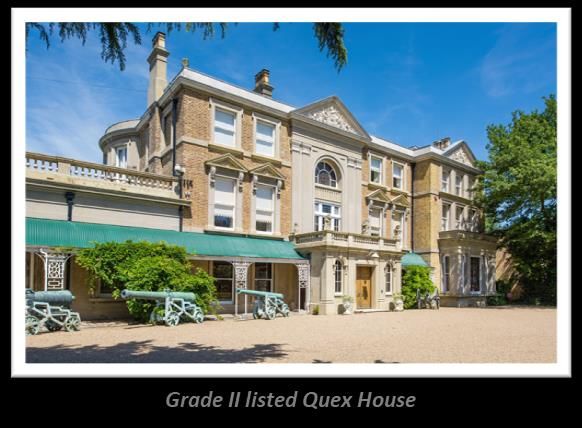
building style arrived in England at a time        Conservation Area is also represented by
when brick-making was increasing, with             “The Smugglers”, a restaurant just off The
three brickworks in Birchington supplying          Square on the north side of Canterbury
local needs.                                       Road. Dating from the 1700’s in the
Some buildings in Birchington use locally
sourced buff-coloured bricks for window
and door surrounds and sometimes as
banding, contrasting with the more
traditional red bricks.
This can be seen in the buildings within
the Conservation Area, along the north
side of Canterbury Road. The Dutch
influence is seen at No. 2 Station Road, (in
use as a restaurant) and Grove House, just
off Canterbury Road, with the gables
typical of the period.
The Square is a rare “open space” for a
village in Thanet – albeit now dominated           “Dutch” style, it was the home of the
by traffic and consequent poor air quality;        Neame family, related to the brewing
it held the Maypole in pre-Civil War days,         dynasty based in Faversham.
then again from 1688 until the 1960’s. The
fountain, now outside the former Queen’s           To the east from The Square the 18th
Head, was donated to the community in              century “villas” are impressive and create
1909 and was turned into an observation            a sense of elegance when arriving from
post in the second world war and is still a        Westgate and Margate.
traffic island.                                    Another former inn, dating from the late
                                                   1600’s and in use as such until 1960 (now
                                                   tea rooms) stands on the north side of
                                                   The Square and was the only one to
                                                   contain adequate stabling for a good
                                                   number of clients’ horses. It’s rendered
                                                   stone elevation and Dutch gables stand in
                                                   contrast to its neighbours.

Many of the buildings around The Square
have stood here for hundreds of years.
Besides the church and cemetery, the
Powell Arms has almost certainly been an
inn since the 1600’s.
The historic charm of buildings in the

                                          Page 7 of 24
Inside the Conservation Area the design through the 20th century.
of buildings is variable, reflecting the One of the features that contributes to
different periods of building but generally
Birchington’s character is the number of
consist of red brick, with some buff- different, independent shops and
coloured decorative features or rendered businesses in the heart of the village.
blocks and some use of flint, particularly Those clustered around The Square and
in boundary walls. Canterbury Road, are at the
principal entrance to Station
Road, the main shopping
street (defined in the Local
Plan as a ‘district shopping
centre’) that ultimately leads
to Minnis Road and the coast.
One of the attractions of
Birchington to visitors in the
late 19th century was the large
variety of privately owned
shops. In 1900 a visitor arriving
from the station would walk
up Station Road to find fifteen
different kinds of retail
Most buildings are two storeys high with outlets, as well as thirteen different
the occasional one being three storeys, service providers, four hotels, a rest home
depending on their original purpose (e.g. and refreshment rooms.
as an inn).
Therefore, they
give the village
a domestic
scale without
any building
dominating the
townscape,
except the
church -
although being
set back from
the road and
surrounded by
green space
this does not
Station Road retains its vibrancy and
intrude on the street scene.
character with different styles of
There are occasional glimpses of buildings, largely from the Victorian era
dwellings behind the main roads and The but also some more modern
Square, some as “infill” developments interventions, which are outside the
such as Walnut Tree Close and Dorothy Conservation Area. Most buildings on
Court, and others like the terrace behind both sides of Station Road have retained
212 Canterbury Road (The Smugglers) their late-Victorian architectural style,
that reflect the intensification of being mainly two-storey with dormers
development from the Victorian era and pitched roofs with living
Page 8 of 24accommodation above shop units at
street level. Those along most of the east
side of the street are also “as built”, some
to resemble “half-timbered” Tudor
buildings.
Away from Station Road there are 20th
century local shopping parades in
Canterbury Road and Minnis Road as well
as a modernised seaside restaurant and
beach cafe at Minnis Bay.
Outside the commercial hub of the
village, the varied architectural styles
illustrate how Birchington has developed,
largely from the Victorian era and the
arrival of the railways which made the
village accessible to visitors from London the Canterbury Road at the western edge
and further afield as well as those wishing of the village. Terraced housing has been
to retire to the area. replicated in modern developments such
as Yew Tree Gardens.
Detached and semi-detached properties
have been the norm for 100 years or more
and these are in evidence across the
village, from the public sector housing off
Park Lane to the large, detached
properties along The Parade and Sea
Road. In addition, new-build apartments
and conversions feature, particularly near
the station and Minnis Bay. Another
aspect of the environment in Birchington
is the number of park homes situated at
Court Mount and caravan and camping
sites off Park Road and at Hawk Place.
The first bungalows were constructed in
the late 19th century, and by the 1930’s
we see the first (exceptional) examples of
‘turret or tower bungalows’ overlooking
the sea between Epple Bay and Beresford
Gap. These are unique and listed at Grade
II. Development continued through the
1930’s to 1950’s but even some more
recent estates have included bungalows.
Victorian terraces in Park Lane and other
parts of the village including the old
coastguard cottages, are a strong feature,
particularly the historic flint and brick
cottages in Mill Lane and Mill Row, just off
Page 9 of 24Apart from churches, there are no “high- village other than a cluster of three, six
rise” buildings anywhere within the floor modernist blocks built in more
recent times. Commercial premises in the
village centre are also “low-rise” and no
single building dominates the street
scene.
A very strong element within
Birchington’s built environment is the
number of green spaces within
developments. Many feature “village
greens” and although these are often
small, they contain trees and flower beds
that break up the street and provide
space for residents to enjoy, whether for
exercise or simply as spaces for quiet
contemplation.
Key Points
• The character of the built environment is defined and enhanced by the existing
proportionate patchwork of design, height and style of buildings and the spaces
between them.
• Buildings in the parish are predominantly low rise. Any new development, either
within or on the edge of the urban area, should not overwhelm or dominate the
existing settlement in terms of height or mass.
• Wherever possible, public greens, trees and hedgerow planting should be used to
screen and provide breaks between groups of new buildings.
• All green spaces within the Parish should be reviewed so that their value to the
community is recognised and that they are appropriately managed in future.
• The attributes of the existing Conservation Area should be appraised and documented.
• Opportunities to extend the Conservation Area or create new ones should be
investigated.
• Opportunities for statutory listing of buildings of architectural and/or historic
significance should be investigated.
• Measures to sustain and enhance the vitality and diversity of businesses in the
commercial heart of the village should be investigated.
• Refer also to Local Plan policies SP16, SP26, SP27 and SP36.
Page 10 of 244. The Coastal Scene
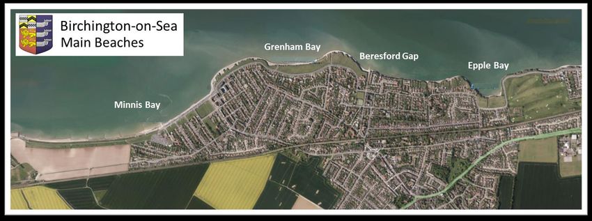
The village is built beside four partly sandy this stretch of coastline. The shingle also
bays, Minnis Bay to the west, Grenham provides an important habitat for roosting
Bay and Beresford Gap towards the centre sea birds.
and Epple Bay to the east. The area to the
Inland, abutting the railway line is public
west of the village, between Birchington
footpath along an embankment,
and Herne Bay is low-lying marshland. providing a link to St Nicholas at Wade
and an alternative route to Reculver and
the coast. Long views to the south and
west can be obtained from this
embankment and many wild flowers can
be seen at different times of the year.
Minnis Bay is the primary beach for
residents and holidaymakers with its
extensive sands and a “crabbing pool” at
low tide.
Once described as “where farmland
meets the sea in a series of sandy beaches,
it is completely unspoilt”.1
Coastal flooding is a concern, particularly
as sea levels continue to rise and present
a growing threat to low lying areas in the
west in the village. A sea defence wall
stretching from Birchington to Reculver
protects the marshes from flooding. Two
man-made lagoons provide habitats for
nesting and over-wintering birds. Along
the top of the sea wall is a shared path for
cyclists, horse-riders and walkers. Fishing
takes place from the shingle beach along
Page 11 of 24Beach huts, a cafe, restaurant, cycle hire The Dip, a remnant of Gore Creek, has
and ice cream hut plus car parking and hosted residents and visitors for over 100
public toilets provide the necessary years. It is reported that in the 1880s The
facilities. The remains of two shipwrecks, Dip was the site of “tennis courts, a small
The Hero and SV Valkyr can be seen at low exhibition hall, tea pavilion and
tide. greenhouses, within a sunken garden.”2
but over the years stormy weather has
reduced The Dip to a simple grassed bowl
enjoyed by many as a sheltered suntrap
and recreation area. It’s final visible link to
the bygone days was lost in 2017 with the
demolition by Thanet District Council of
the steps that had served generations
possibly since 1898.
At the east end of the bay where the chalk
begins to rise the buff brick, Victorian
arches can be seen embedded in the cliff
face. Neglected, overgrown and obscured
by beach huts these are a nod to the rich
history of the Bay. Similarly, the nearby
Waterborne activities abound with casual public toilet block has been closed for
and competitive sailing organised by the years and the district council owned
Minnis Bay Sailing Club and Minnis Bay block-built beach chalets are disused,
Windsurfing Club; both clubs have their deemed dangerous and cordoned off.
headquarters premises in the Bay. The
Nayland Boat Sea Angling Society launch
and store their boats and equipment here
too. Birchington Sea Cadets also have a
base in Prospect Road.
Behind the promenade, across The
Parade the grassed open spaces boast
three splendid shelters recently
refurbished by volunteers following
transfer of ownership from Thanet
District Council to the Parish Council.
To the east of Minnis Bay the land rises,
forming chalk cliffs and cliff stacks behind
the shingle beaches at Grenham Bay and
Beresford Gap and the sandy beach at
Epple Bay.
The “shared access” sea defence wall
stretches along the foot of the cliffs here
to prevent coastal erosion and there are
several examples of long disused landing
Page 12 of 24stations and access tunnels cut into the are scheduled for a new lease of life when
cliffs. refurbished in future phases by a local
volunteer group. At Epple Bay there is a
section of a pier extending beyond the
chalk cliffs but this was never extended
out into the sea. This section is backed by
high brick walls which were constructed
in the early 1900’s using bricks from the
brickfields that were situated on land
some metres back from the cliff edge.
A watch tower, war time pill box and
coast guard cottages were all located
above Epple Bay but subsequently
demolished. Panoramic views are
obtained from the open space on the top
of the cliffs here which, together with the
Several narrow paths cut
through the cliffs to afford
access to the sea; these
were originally created by
farmers to collect seaweed
from the beach but are also
known to have been used
by smugglers. A road to the
beach at Beresford Gap
facilitates access for water-
skiing and powerboats to
use this stretch of
coastline. There are also a
few private accesses from
properties in Cliff Road.
golf course to the east, provides a green
On the grassy clifftops above these
wedge between the built up areas of the
beaches are more historic shelters, which
village and Westgate on Sea.
1
From the AA book of the seaside – First edition 1972
2 From an article by Colin Cordine for the Birchington Heritage Trust
Key Points
• The coastal scene is the product of the interaction between the foreshore, the cliffs and the
open spaces beyond; all should be carefully protected.
• The cliff top green spaces should form part of a review of open spaces to ensure that their
special significance is recognised.
• To protect the character of the bays and clifftops further commercial development along the
coastline should be contained within those areas already designated for such activity.
• Use of powered recreational craft can disturb marine life and should be restricted. There should
be no additional launch points nor development or intensification of existing launch points
anywhere along the parish coastline.
• Refer also to Local Plan policies SP28, SP29
Page 13 of 245. Birchington Landscape Character
In 2017 Thanet District Council, the local In September 2020 the Parish Council
planning authority, commissioned Land asked LUC if they could provide data
Use Consultants (LUC) to produce a specific to Birchington. They kindly
Landscape Character Assessment for the extrapolated data from their 2017 district-
whole of the district. This was published in wide assessment and submitted a report4
August 20173 and is appended to the to the Neighbourhood Planning team. This
adopted Local Plan (July 2020) as provides useful background information. It
Supplementary Planning Guidance. uses maps from the 2017 report
highlighting features specific to
The Landscape Character Assessment
Birchington:
classified different types of landscape.
Those relevant to Birchington Parish (and • geology
described in more detail below) are: • topography
• historic landscape character
C1 - St Nicholas at Wade Undulating Chalk • cultural heritage features
Farmland • priority habitats
C2 - Central Thanet Undulating Chalk • biodiversity
Farmland • dark night skies
D1 - Parklands and Estates – Quex Park • tranquillity
E2 - Wade Marshes • woodland
F3 - Minnis Bay • agricultural land classification
G2 - North Thanet Coast • international, national and local
coastal designations5
Page 14 of 24The undulating chalk farmland is a and trees along the boundaries to Park
particular landscape feature in Thanet. Lane, Manston Road, Shottendane Road
and Park Road are strong features in the
C1 and C2 (Undulating Chalk Farmland)
landscape and form an effective screen
are important for their long distant views
around the facilities in the Quex estate.
to the marshes and sea while the
agricultural land performs a settlement Two important historic features of the
separation function. Key examples are the Park are the Grade II listed Waterloo
land to the east of Birchington, with views Tower and a round castellated brick
from Park Lane across open farmland to tower to the north of the main House.
Westgate; from the Quex Park boundary Waterloo Tower is a visible landmark
when seen from the south.
of Manston Road looking south to Acol;
and looking west across Brooksend to St There are also ancient remains of a
Nicholas at Wade. settlement on farmland to the east of
Quex Park. The Local Plan contains a
These areas of high quality agricultural
specific policy regarding Quex Park.6
land are of value for farmland and
roosting coastal birds. The openness and E1: Stour Marshes and E2: Wade
undeveloped character of the farmland Marshes are two marshland landscapes
contributes to the essentially rural which formerly separated the Isle of
character of the area and relatively dark Thanet from the mainland and formed
skies, although the light pollution from part of the former Wantsum channel.
the Thanet Earth glasshouses is
significant.
Quex Park (D1) is unique within the
Thanet context, comprising a formal and
extensive wooded parkland and amenity
landscape within an otherwise open
intensively farmed landscape.
It possesses a formal landscape structure
and gardens that act as an effective
setting to Quex House (Grade II listed).
The parkland is intensively cultivated
between the tree belts, with limited
grazing pasture remaining. The hedgerow
This former channel stretches from
Reculver (in Canterbury District) to
Richborough (in Dover district) marked by
the remains of Roman forts at these
locations. These Roman forts guarded the
two entrances of the channel and the
area is potentially rich in archaeology.
There are about 80 Roman sites within
10km of Birchington,7 as well as Bronze
Age remains near Brooksend Farm.
Therefore, this is a sub-regionally
important landscape as it extends into the
Page 15 of 24neighbouring districts of Canterbury and the railway line and to the north by the
Dover and includes the flood plain of the sea wall.
River Stour.
Farmland to the east forms a natural
Both areas are characterised by a vast, break between Plum Pudding and the
flat, open landscape defined by the edge of the village, providing a rural
presence of an ancient field system, an setting for the modest cluster of farm and
extensive ditch and dyke system, the sea equestrian buildings, without them
walls and isolated groups of trees. These intruding significantly on the views and
elements provide important visual vistas looking south from the sea wall and
evidence of the physical evolution of the west from the village boundary.
Wantsum Channel and,
like other marsh areas in
Kent, produce huge open
skies.
The former grazing land
has been improved and
managed as arable
farmland; however, it still
retains its network of
ditches which provide
biodiversity interest. In
both of these landscapes it
is important to conserve
the long distance views to
the Thames Estuary to the north and Some tourist facilities have been
Pegwell Bay to the south. permitted at Minnis Bay. Any future
development would have to conform to
Undeveloped (Area F3) describes Minnis
the Local Plan8 which states:
Bay and the coast to the west. The beach
at Minnis Bay is popular with residents “Policy E10: On those beaches identified
and visitors. Landward of Minnis Bay lies as intermediate beaches [i.e. Minnis Bay],
the Plum Pudding Equestrian Centre and and where scope exists for such
Hawk Place camping and caravan site, development, the Council will support
accessed via a single track lane from Dane proposals for small scale tourism and
Road. The site is bounded on the south by leisure development (e.g. tourist
accommodation, kiosks supplying food
and refreshments, beach huts and beach
furniture), subject to the scale of provision
being consistent with the intermediate
status of the beach and satisfactory
design and siting of development.
Development proposals must avoid or
fully mitigate against any impact upon the
designated nature conservation sites, and
will be subject to the Habitats
Regulations”.
Page 16 of 24The long coastline is one of Thanet's main strategy within the Neighbourhood Plan.
assets. There are two character areas The cliff top affords long views to Margate
associated with the developed coast: G1: in the east as well as to Reculver and the
Ramsgate and Broadstairs Cliffs and G2: Isle of Sheppey in the west.
North Thanet Coast. The North Thanet
Coast extends from the western edge of
Birchington along to the northern edge
of Margate. It is characterised by a series
of sandy bays with chalk reefs, mudflats
and rock pools backed by a line of low
white chalk cliffs. There are extensive
views along the coast from Birchington
towards Margate, with the Turner
Contemporary gallery visible in the
distance.
With the exception of the Green
Wedges9, which are protected open
landscapes within built- up areas, the
developed coast is considered urban. The The Westgate & Birchington golf club is a
coastal strip is characterised by the significant green space to the east of the
presence of traditional seaside village and straddles the main railway
architecture, beaches and some extensive line. There are extensive views across the
public open clifftop areas. course from Epple Bay towards Westgate.
Hedgerow along the southern boundary
The pattern of bays and chalk headlands forms a natural barrier to the A28 trunk
provides long sweeping and panoramic road. On the opposite side of the road,
views of the coast, which are often more hedges screen King Ethelbert’s
complemented by a positive relationship school buildings, whilst the school playing
with adjacent built development. The fields create a green wedge with views
green spaces along the cliff top in across farmland to the south.
Birchington and adjacent to Minnis Bay
3. Thanet Landscape Character Assessment August 2017
serve an important function as they 4. Landscape Character Assessment – Birchington
create a sense of openness and a semi- September 2020
5. SSSI, SAC, SPA, Ramsar – see glossary at end
natural break between the coast and the 6. Thanet District Local Plan Policies E12 and SP26
built environment. 7. Historic England – Ancient Monuments records
8. Thanet District Local Plan Policy E10
They will form part of the green spaces 9. Thanet District Local Plan Policy SP25
Key Points
• There should be no significant intensification of tourist facilities between Epple Bay and
Minnis Bay nor at Hawk Place/Plum Pudding, to conserve and protect the coast, and
views and vistas in all directions.
• The agricultural land between Daryngton Avenue and Hawk Place should be designated
as a “green wedge” and remain undeveloped to protect the views and vistas towards
and from the coast.
• See Landscape Character Assessment 2017 which is adopted as supplementary planning
guidance to the Local Plan.
Page 17 of 246. Legislation
The coast is subject to a number of habitat including over 30 nationally rare species
designations, which are shown on the of terrestrial and marine plants, 19
map in the LUC Landscape Character nationally rare and 149 nationally scarce
Assessment report (Sept. 2020)10 and invertebrate species and roost sites for
described in the glossary at the end. migrating and wintering birds.
Thanet has two SSSIs which are Thanet
All the designations apply here but the
Coast SSSI and the Sandwich Bay and
Thanet Coast Site of Special Scientific
Hacklinge Marshes, one National Nature
Interest (SSSI) on Birchington’s coast is
Reserve at Pegwell Bay which straddles
more fully described in the LUC Landscape
the District boundary with Dover. The
Character Assessment.
Thanet Coast is also a designated Marine
It is a nationally designated site under Conservation Zone.
Section 28 of the Wildlife and Countryside
The National Planning Policy Framework
Act 1981, having important wildlife or
(NPPF 2019) states that local plans should
geological value. This Act, as amended by
take account of the roles and character of
the Countryside and Rights of Way Act
different areas, promoting the vitality of
2000, imposes a duty on public bodies
main urban areas and recognising the
exercising statutory functions which may
intrinsic character and beauty of the
affect SSSIs, to take reasonable steps to
countryside. The NPPF also states that the
further enhance the features for which
planning system should contribute to and
the site is designated.
enhance the natural and local
The nationally designated sites (SSSI and environment by protecting and
National Nature Reserves), have similar enhancing valued landscapes.
features to the international sites,
The Thanet District Local Plan 2020 acknowledges the significance of the landscape on the
Isle of Thanet and contains a specific policy on landscape character areas. This is set out in
full below:
Policy SP26 – Landscape Character Areas: The Council will identify and support opportunities
to conserve and enhance Thanet's landscape character and local distinctiveness.
Development proposals should demonstrate how their location, scale, design and materials
will conserve and enhance Thanet's local distinctiveness, in particular:
1. Its island quality surrounded by the silted marshes of the former Wantsum Channel and
the sea;
2. A sense of openness and 'big skies', particularly in the central part of the District;
3. Its long, low chalk cliffs and the sense of 'wildness' experienced at the coast and on the
marshes;
4. Gaps between Thanet's towns and villages, particularly those areas designated as Green
Wedges;
5. Long-distance, open views, particularly across the Dover Strait and English Channel,
North Sea and across adjacent lowland landscapes; and
6. Subtle skylines and ridges which are prominent from lower lying landscape both within
and beyond the District.
Development proposals should demonstrate how they respect and respond to the character,
key sensitivities, qualities and guidelines of the relevant landscape character areas, as
Page 18 of 24detailed in the Landscape Character Assessment (LCA)2 and summarised below:
All development should seek to avoid skyline intrusion and the loss or interruption of long
views of the coast and the sea, and proposals should demonstrate how the development will
take advantage of and engage with these views.
Development should generally be directed away from the Stour Marshes (E1), Wade Marshes
(E2) and Pegwell Bay (F1) character areas (as detailed in the LCA), as these are largely
undeveloped and key to retaining the island character of Thanet.
The undeveloped character of Landscape Character Type F: Undeveloped Coast should also
be maintained.
Proposals on the coast (within landscape character types F: Undeveloped Coast and G:
Developed Coast and the surrounding area) should respect the traditional seafront
architecture of the area, maintain existing open spaces and should ensure that recreational
and wildlife opportunities are not compromised by development. Proposals should maintain
and enhance the setting of sandy bays, low chalk cliffs and associated grassland and long
sweeping views of the coastline.
The rural-urban boundary is distinctive in some parts of Thanet, particularly where there is
an abrupt urban edge and where the countryside extends into the urban areas as Green
Wedges. The distinction between town and countryside should be retained.
Development proposals that conflict with the above principles will only be permitted where
it can be demonstrated that they are essential for the economic or social well-being of the
area. In such cases, landscape impacts should be minimised and mitigated as far as possible”.
The Thanet Landscape Character qualities and guidelines for future
Assessment provides more detailed management of these areas. It has been
guidance for each of the local landscape adopted as supplementary planning
character areas. It highlights key guidance and therefore carries as much
characteristics, historic, cultural and weight as the main policies in the Local
natural influences, key sensitivities and Plan.
10. LUC Landscape Character Assessment – Birchington September 2020
Key Points
• the coastal zone is subject to a number of special designations and should be protected
from development or intrusive activities
• See Local Plan policy SP26 and Landscape Character Assessment 2017
Page 19 of 247. Sensitivities and Concerns
The local community places great and fundamentally change the nature of
emphasis on retaining the character of the approaches to the village from the
Birchington as a seaside village. west, with the urban edge being highly
visible on the skyline. The extensive views
Residents have consistently expressed
and vistas enjoyed across existing
the view that large and small green spaces
farmland looking out from the western
and agricultural land should be protected
edge of the village, from Acol and from
from development. Whilst accepting that
the coast will be changed forever.
some development is inevitable, they do
not want to see extensive new Since the adoption of the Local Plan in
development in the Parish and cherish the 2020, the importance of access to green
long views and vistas to the south and spaces for mental and physical well-being
west of the village, as well as the historic has become even more evident.
estate of Quex Park and the open land to
The Landscape Institute published
the east and south11. Greener Recovery: Delivering a
Notwithstanding the views expressed by sustainable recovery from Covid-19” and
the community, land for the development has called for urgent investment in parks
of 1600 houses, a school and convenience and open spaces.
store to the south-west of the village plus Along similar lines, Friends of the Earth
the possible extension of the existing has ranked neighbourhoods from A (best)
medical centre and new roads has been to E, by their closeness to private gardens,
designated in the Local Plan 2020.
Policy SP1612 sets out requirements for public parks or open fields. Its “England’s
the master plan that will need to Green Spaces Gap” found one in five
accompany the planning application. people struggle to access green space.
Indicative proposals are shown on the Similar data showing access to nature is
map above. If approved, this application by no means equal, has come from The
will substantially increase the population Ramblers’ use of YouGov data.
Page 20 of 24The Ramblers say that “we need to build green spaces linked by safe walking
on lessons learned from the pandemic. routes”.
People want to visit green spaces on their
doorstep, where they can enjoy the 11. See village appraisals 1988, 1997, 2018 and the Community
benefits of connecting with nature. Our Design Day 2019 report
12. See Local Plan policy SP16 – Strategic housing site, South
towns and cities should be designed to West Birchington
make this a reality, with nature-filled
Key Points
• Policies in the Neighbourhood Plan should underpin the Local Plan, demonstrating recognition
for the importance of Birchington’s natural, coastal, historic and built environments to the local
community
• The policies should also seek to manage future changes in light of the impact of the Covid-19
pandemic and the proposed new development to the south-west of Birchington
• Projects and initiatives within the Parish should aim to protect, conserve and enhance the quality
of life for residents and visitors, building on the area’s historic and cultural past whilst being
progressive in outlook
• Green, open spaces should be readily accessible to all
Page 21 of 248. Conclusions and Recommendations
The national importance of the coastal supports the local community feeling and
zone, chalk farmland, marshes and Quex the need to seek to ensure that greater
Park have been highlighted within the emphasis is given to all green spaces,
Local Plan 2020 and the district-wide agricultural land, views and vistas and the
Landscape Character Assessment 2017 as setting of archaeological and historic
well as the Character Assessment for assets in the future.
Birchington 2020. The policies in the Neighbourhood Plan,
Policies within the National Planning should therefore, aim to strengthen the
Policy Framework 2019 and the Local Plan Local Plan at community level.
together with national and international When adopted as Supplementary
designations for the chalk coast should Planning Guidance13 the Neighbourhood
afford protection from inappropriate Plan should help to ensure that some of
development in the future.
the impact of development is mitigated
This recognition of the importance of and that there is enhanced protection for
protecting the natural environment and the remaining agricultural land and green
the fundamental aim of sustainability spaces around the village in the future.
13. The Neighbourhood Plan becomes SPG once adopted following referendum in 2021
Page 22 of 249. Recommendations to inform policy making in the
Neighbourhood Plan
The key points in this document summarise the issues that need to be addressed and form
the basis of our recommendations, as follows:
1. the scale, height, massing and design of any development within or adjacent to the
existing urban area of the village must respect the character of the existing built
environment, natural and man-made landscapes and comply with any local design codes
2. a very strong feature of the character of the village is its tradition and preponderance of
low rise buildings; development of one and two storey buildings should be supported,
three or more storey buildings should only be permitted in exceptional circumstances
3. that new developments on the edge of the village incorporate a natural green “soft” break
to provide an appropriate transition between the proposed new development and the
existing urban settlement
4. tree planting and green spaces break up the urban mass of new building on the skyline
5. that measures such as green lanes are incorporated into new developments that are likely
to compromise historic and iconic views and vistas
6. views and vistas across open farmland to the east, south and west of the village are
protected from further development
7. open farmland between the western edge of the village and Plum Pudding/Hawk Place is
protected from development
8. that existing wildlife habitats in hedgerows and on undeveloped land are protected and
opportunities are created to improve biodiversity by such as planting of new hedgerows
and trees and creation wet habitats.
9. all existing green spaces in the village and new green spaces are designated as local green
space14
10. management plans are prepared for public open or green spaces, where appropriate, to
guide future maintenance and developments
11. any development at Plum Pudding/Hawk Place is of an appropriate scale and has minimal
impact on the open landscape of the marshes
12. the trees, hedges, gardens and farmland of Quex Park and Estate should be retained and
protected as they form an important feature in the landscape and a valued green space
on the edge of the village
13. renewed efforts are made to reduce light pollution from Thanet Earth and that any
extension to this horticultural facility should be subject to rigorous conditions to reduce
its impact on the landscape
14. See separate Birchington Neighbourhood Plan Assessment of Green Open Spaces
Page 23 of 2410. Glossary of terms
Site of Special Scientific Interest (SSSI): Sites designated by Natural England under the
Wildlife and Countryside Act 1981.
Special Areas of Conservation (SAC): Areas given special protection under the European
Union’s Habitats Directive, which is transposed into UK law by the Habitats and Conservation
of Species Regulations 2010.
Special Protection Areas (SPA): Areas which have been identified as being of international
importance for the breeding, feeding, wintering or the migration of rare and vulnerable
species of birds found within European Union countries. They are European designated sites,
classified under the Birds Directive.
Ramsar sites: Wetlands of international importance, designated under the 1971 Ramsar
Convention
International, national and locally designated sites of importance for biodiversity: All
international sites (Special Areas of Conservation, Special Protection Areas, and Ramsar
sites), national sites (Sites of Special Scientific Interest) and locally designated sites including
Local Wildlife Sites.
Page 24 of 24You can also read