Effects of Wildfires on Runoff and Erosion - Lee H. MacDonald Watershed Science Program Colorado State University, Fort Collins, CO

Page created by Margaret Arnold
 
CONTINUE READING
Effects of Wildfires on Runoff and Erosion - Lee H. MacDonald Watershed Science Program Colorado State University, Fort Collins, CO
Effects of Wildfires on Runoff and Erosion

                Lee H. MacDonald
            Watershed Science Program
     Colorado State University, Fort Collins, CO
Effects of Wildfires on Runoff and Erosion - Lee H. MacDonald Watershed Science Program Colorado State University, Fort Collins, CO
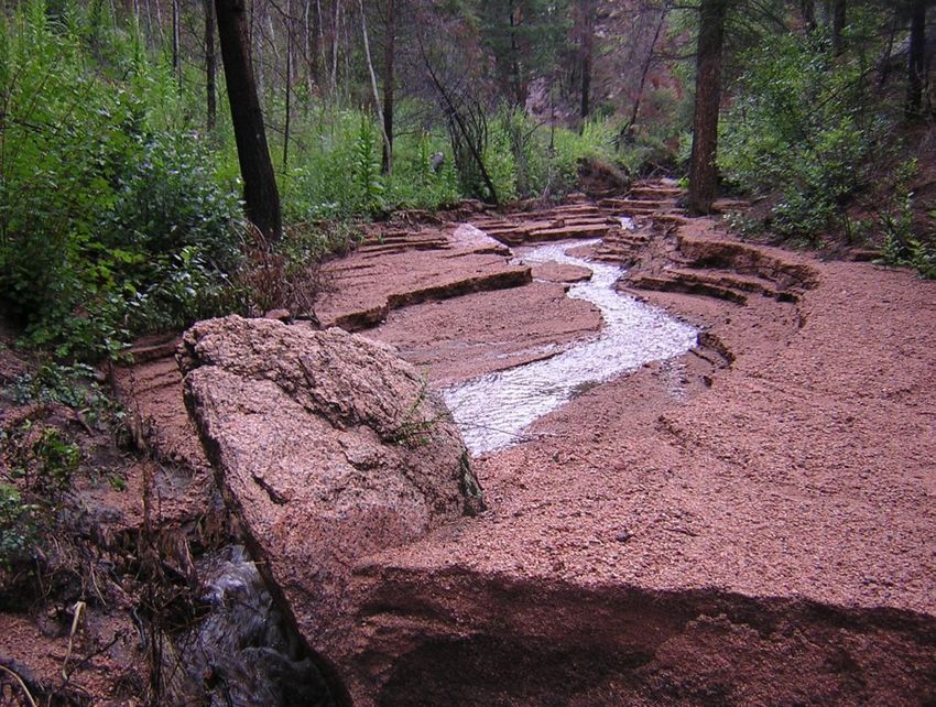
Contributors
•   Tedd Huffman (M.S., 2002);
•   Juan Benavides-Solorio (Ph.D., 2003);
•   Joe Wagenbrenner (M.S., 2003);
•   Matt Kunze (M.S., 2003);
•   Zamir Libohova (M.S., 2004);
•   Jay Pietraszek (M.S., 2006);
•   Daniella Rough (M.S., 2007);
•   Duncan Eccleston (M.S., 2008);
•   Keelin Schaffrath (M.S., 2009);
•   Darren Hughes (M.S., 2010);
•   Ethan Brown (M.S., 2009);
•   Dr. John Stednick;
•   Isaac Larsen (Research Assistant, 2004-2007);
•   Sergio Alegre (visiting Ph.D. student, 2010).
Effects of Wildfires on Runoff and Erosion - Lee H. MacDonald Watershed Science Program Colorado State University, Fort Collins, CO
Why the concern about wildfires?
Effects of Wildfires on Runoff and Erosion - Lee H. MacDonald Watershed Science Program Colorado State University, Fort Collins, CO
Hayman Fire, Colorado: August 2004
Effects of Wildfires on Runoff and Erosion - Lee H. MacDonald Watershed Science Program Colorado State University, Fort Collins, CO
Channel incision from a 20 mm/hr rain event after
  the Cerro Grande Fire near Los Alamos, NM

                             Photo by John Moody, USGS
Effects of Wildfires on Runoff and Erosion - Lee H. MacDonald Watershed Science Program Colorado State University, Fort Collins, CO
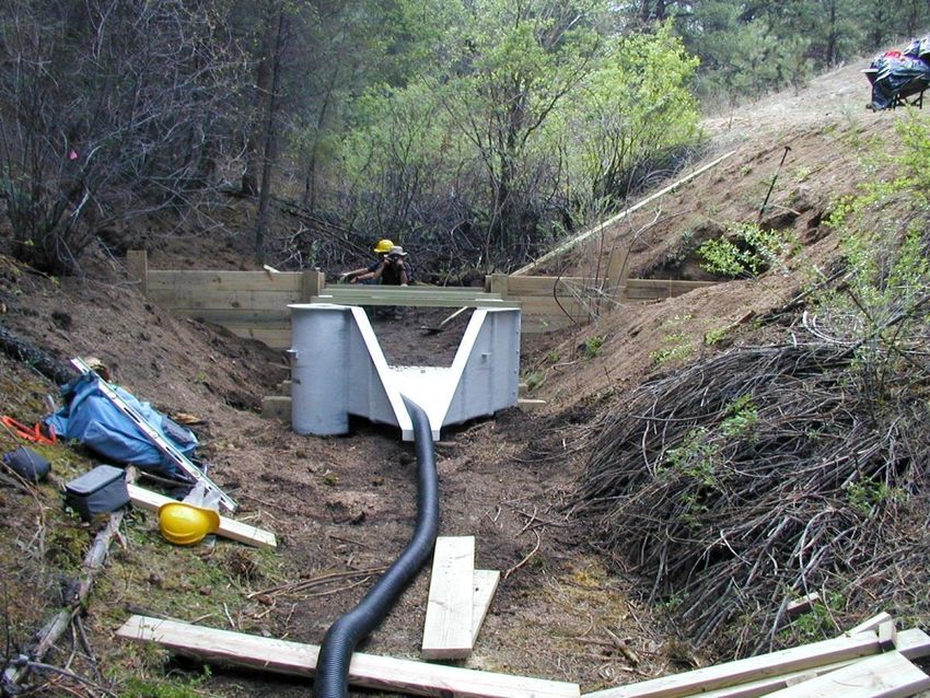
Alluvial fan from Saloon Gulch extending into
    the South Platte River, Summer 2004
            (2 years after burning!)
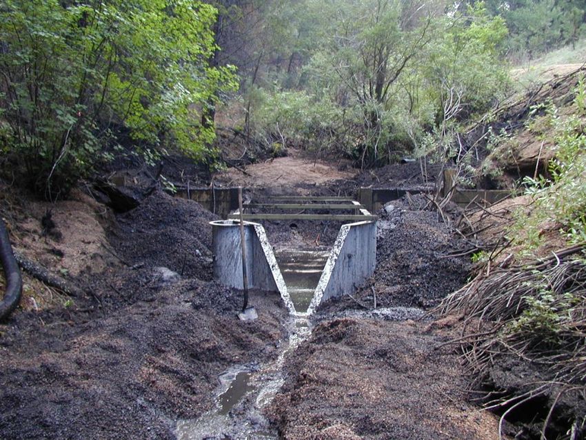
Effects of Wildfires on Runoff and Erosion - Lee H. MacDonald Watershed Science Program Colorado State University, Fort Collins, CO
Post-fire Hydrology
Effects of Wildfires on Runoff and Erosion - Lee H. MacDonald Watershed Science Program Colorado State University, Fort Collins, CO
Objectives
1. Provide a process-based understanding of the effects
    of wild and prescribed fires on soils, runoff, and
    erosion;
2. Evaluate the relative importance of different
    controlling factors on post-fire erosion rates;
3. Determine the rate of recovery to pre-fire conditions;
4. Discuss how post-fire processes and recovery vary
    with increasing scale, and put the effects of wildfire
    in a broader context.
Effects of Wildfires on Runoff and Erosion - Lee H. MacDonald Watershed Science Program Colorado State University, Fort Collins, CO
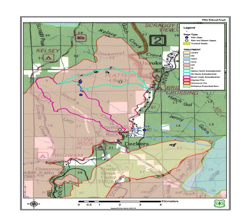
Post-fire Effects Vary with Burn Severity
    1) High severity: complete consumption of organic
    horizon and alteration of the structure or color of the
    underlying mineral soil; loss of aggregates
    (“pulverization”):
    2) Moderate severity: consumption of litter layer but
    no visible alteration of the surface of the mineral soil;
    3) Low severity: only partial consumption of the
    surface litter.

Severity is not equal to intensity (heat loss per unit width
   per unit time), but severity and intensity often
   assumed to be closely correlated;
Why the sharp increase in runoff and
erosion after some high-severity wildfires?
1. Loss of canopy decreases interception and
    evapotranspiration, increasing runoff;
2. Loss of litter decreases interception and exposes soil to
    raindrop impacts (increased erodibility) and sealing;
3. Loss of soil organic matter disaggregates or pulverizes
    the soil, and this increases soil erodibility;
4. Increase in soil water repellency can decrease
    infiltration and increase surface runoff;
5. Loss of litter decreases surface roughness and
    increases runoff velocities, increasing erosion;
  Effects are synergistic, but which is most important?
Soil Water Repellency
Fire-induced soil water repellency

                         (DeBano, 1981)
Methods of Analysis
Water drop penetration time (WDPT):
•   Apply drops at different depths, beginning at mineral soil
    surface;
•   Indefinite waiting time;
•   Assesses persistence of soil water repellency.

Critical surface tension test (CST):
•   Apply 5 drops of de-ionized water;
•   If 4 of 5 drops are not absorbed within 5 seconds, test
    solutions with progressively higher ethanol concentrations
    (increasing ethanol concentrations decrease surface tension);
•   Critical surface tension (CST) is the tension of the first
    solution that is readily absorbed into the soil (“strength”).
Critical surface tension in wild and
                            prescribed fires: High-severity sites
                                    (bottom two sites are prescribed fires)
                           80
Critical surface tension

                           70
      (dynes cm -1)

                           60                                            Crosier M tn.

                                                                         Hi M eadows
                           50
                                                                         B obcat

                           40                                            Lower Flowers

                                                                         Dadd B ennett
                           30
                                0        3        6        9       12         15         18
Huffman et al., 2001                                  Depth (cm)
Critical surface tension in wild and prescribed
          fires: Moderate-severity sites
                                       (bottom two sites are prescribed fires)
                              80

                              70
   Critical surface tension
          (dynes cm -1)

                              60                                            Hi M eado ws

                                                                            Cro sier M tn.
                              50
                                                                            B o bcat

                                                                            Lo wer Flo wers
                              40
                                                                            Dadd B ennett

                              30
                                   0         3       6        9        12        15           18

Huffman et al., 2001                                     Depth (cm )
Critical surface tension in wild and prescribed
               fires: Low severity sites
                                    (bottom two sites are prescribed fires)

                           80
Critical surface tension

                           70
                                                                          Hi M eadows
       (dynes cm -1)

                           60                                             B obcat

                                                                          Crosier M tn.
                           50
                                                                          Lower Flowers
                           40
                                                                          Dadd B ennett

                           30
                                0     3         6          9         12             15    18

Huffman et al., 2001                                  Depth (cm )
Median soil water repellency over time,
                                                           Star Fire, Tahoe National Forest
                                                75
Median critical surface tension (dynes cm -1)

                                                70

                                                65

                                                60

                                                55

                                                50

                                                                                                   Unburned
                                                45
                                                                                                   Summer 2002 (10 months)
                                                40                                                 Summer 2003 (22 months)

                                                                                                   Summer 2004 (34 months)
                                                35

                                                30
                                                     0        2.5      5                7.5              10              12.5
                                                                           Depth (cm)

                                                                                        E. Chase, M.S.. thesis, Colorado State Univ., 2006
Mean soil water repellency by depth:
                                              Unburned vs. burned sites, summer 2002
                                                  Hayman fire (n=36)
                                         80
                                                  Schoonover fire (n=18)
Critical surface tension (dynes cm-1 )

                                                  Trumbull: unburned
                                         70       (n=39)

                                         60

                                         50

                                         40

                                         30
                                              0             3                  6        9               12
                                                                           Depth (cm)
                                                                                            D. Rough, 2007
Soil water repellency from 2002-2004:
                                           Upper Saloon Gulch, Hayman fire
                                         80

                                         75
Critical surface tension (dynes cm -1)

                                         70

                                         65

                                         60

                                         55

                                                                          2004
                                         50
                                                                          2003
                                         45
                                                                          2002

                                         40                               No water repellency

                                         35

                                         30
                                              0      3       6        9             12
                                                         Depth (cm)
                                                                                   D. Rough, 2007
Spatial variability in soil water repellency:
   Plot H1, high severity, Hayman fire

     14

     12                                                        Moles of
                                                         4     ethanol
     10
                                                               per liter
                                                         3
 Meters

          8
                                                         2

          6                                              1

          4                                              0.4

                                                         0
          2

          0
           0   2   4   6     8      10   12   14
                           Meters
                                          Woods et al. 2007, Geomorphology
Summary: Soil Water Repellency
• Soils in unburned areas usually water repellent;
• Fire-induced water repellency is usually shallow
  (maximum of 9 cm);
• May be stronger in prescribed fires due to higher fuel
  loadings and slower rate of fire spread;
• Very high spatial variability;
• Relatively rapid recovery (≤ 2 years);
• Not present under wet conditions (~10-35 percent soil
  moisture), depending on fire severity;
• CST faster and more consistent than WDPT.
Supporting Data
Three papers on my web site (type “Lee MacDonald” into
    google):
1.   Huffman, E.L., L.H. MacDonald, and J.D. Stednick, 2001.
     “Strength and persistence of fire induced soil hydrophobicity
     under ponderosa and lodgepole pine, Colorado Front Range”,
     Hydro. Proc. 15: 2877-2892.
2.   MacDonald, L.H., and E.L. Huffman, 2004. “Persistence and
     soil moisture thresholds”, Soil Sci. Soc. Am. J. 68: 1729-1724;
3.   Doerr, S.H., R.H. Shakesby, and L.H. MacDonald, 2009.
     “Soil water repellency: a key factor in post-fire erosion?” In
     Restoration Strategies after Forest Fires, edited by A. Cerda
     and P.R. Robichaud, Science Publishers, Inc., Enfield, NH.
Sediment Production at the
     Hillslope Scale
Total plot years of data by treatment
Untreated
        High severity                              319
        Moderate severity                          55
        Low severity                               34
Treated (all high severity)
        Seeding and scarification with seeding     36
        Straw mulch and straw mulch with seeding   60
        Contour-felled logs                        44
        Ground-applied hydromulch                  20
        Aerially-applied hydromulch                20
        Polyacrylamide                             12
Total                                              600
Sediment yields by fire severity and season:
  First two years after burning (Colorado)

                           10.0

                                                  Summer Rainfall (Jun-Oct)
Sediment yield (Mg ha-1)

                            8.0                   Snowmelt (Nov-May)

                            6.0

                            4.0

                            2.0

                            0.0
                                  High     Moderate                  Low
                                         Fire severity
Role of surface cover,
 recovery over time,
and rainfall intensity
Sediment production: Summer 2001 (before Hayman fire)

                    1.20

                    1.00
Sediment (kg/m 2)

                    0.80

                    0.60

                    0.40

                    0.20

                    0.00
                           1   2    3     4         5        6        7      8   9   10

                                        Pairs of sedim ent fences (n = 20)
Mean percent ground cover in Upper Saloon Gulch in
                     2001 (prior to burning) and 2002 (after the Hayman fire)
                   10 0
                                                              2001
                    90
                                                              2002
                    80
Ground cover (%)

                    70

                    60

                    50

                    40

                    30

                    20

                    10

                     0
                          1\ 8   1\ 9   1\ 12 1\ 13   1\ 14 1\ 15 1\ 16   1\ 17 1\ 18   1\ 19 1\ 2 0 1\ 2 1 1\ 2 2 1\ 2 3 1\ 2 4 1\ 2 5 1\ 2 6 1\ 2 7 1\ 2 8 1\ 2 9

                                                                                         Swale
Sediment from 11 mm of precipitation in
     45 minutes on 21 July 2002
Sediment production after Hayman fire:
                     21 July 2002 storm (11 mm in 45 minutes)
                    1.40
                               Control

                    1.20       "Treated" (not
                               implemented)
                    1.00
Sediment (kg/m 2)

                    0.80

                    0.60

                    0.40

                    0.20

                    0.00
                           1        2       3   4   5           6   7   8   9   10

                                                        Pairs
Vegetation recovery over time
                      Bobcat fire, sediment fence #9
Year 2000, 15 days after fire        Year 2001
96% Bare soil                        69% Bare soil

Year 2002                            Year 2003
17% Bare soil                        12% Bare soil
Percent bare soil vs. time since burning
                    100                          High severity           y = -26.09Ln(x) + 70.03
                                                                                R2 = 0.63
                                                 Moderate severity       y = -21.86Ln(x) + 45.75
                     80                                                         R2 = 0.60
                                                 Low severity            y = -10.44Ln(x) + 26.21
                                                                                 R2 = 0.49
Percent bare soil

                     60

                     40

                     20

                      0
                          0   1   2   3     4     5        6         7          8        9         10

                                      Time since burning (years)
Sediment yield vs. percent bare soil

                                50
                                                       0.095x
Sediment yield (Mg ha-1 yr-1)

                                         y = 0.0029e
                                         p < 0.0001
                                40       R2 = 0.61
                                         n=345

                                30

                                20

                                10

                                 0
                                     0             20            40         60      80   100

                                                                Percent bare soil
Event-based sediment production vs. I30:
                         High-severity wildfires
                                               1-3 years after burning
                                      10       4-5 years after burning                              2
                                                                                                R = 0.62
Mean sediment production (Mg ha -1)

                                       8

                                       6

                                       4

                                       2

                                                                                          R2 = 0.50
                                       0
                                           0            10               20         30                  40   50
                                                                                               -1
                                                             30-minute maximum intensity (mm hr )
Sediment production over time:
  Pendola fire, Eldorado N.F.
Post-fire erosion vs. percent bare soil:
         Pendola fire, Eldorado N.F.
        18
                     1999-2000
        16           2000-2001
) -1 yr-1

                     2001-2002
        14

        12

        10

             8                             y=0.12900.0577x

             6                             R2=0.77
                                           p=0.01
             4

             2

             0
  Sediment

                 0   10   20     30   40     50      60      70   80   90
                               Percent Bare Soil (%)
Is all this sediment coming from:
(a) rainsplash and sheetwash on
     the hillslopes; or
(b) rill, gully, and channel erosion?
Upper Saloon Gulch: 10 July 2002

17 mm rain in 2 hours
Sediment yields from swales vs.
                                planar hillslopes in 2001: Bobcat fire
Sediment production (kg m -2)

                                1.4
                                1.2
                                 1
                                0.8                                                    R2 = 0.57
                                                                                       p = 0.01
                                0.6
                                0.4
                                0.2                                                    R2 = 0.53
                                                                                       p = 0.007
                                 0
                                      0   50        100            150        200      250
                                               Erosivity (MJ mm ha -1 h-1)

                                          Planar hillslopes 2001         Swales 2001
Measuring rill erosion, Hayman fire
Rill erosion in Swale 4: Storm on 21 August 2003
      0                                                                              0

      -5                                                                         -5
                                                                                                                      2
     -10                                1                                       -10

     -15                                                                        -15
cm

                                                                          cm
     -20                                                                        -20
     -25                                                                        -25
                                                        15-Aug-02
     -30                                                                        -30
                                                        23-Aug-02                                                                           15-Aug-02
     -35                                                                        -35
                                                                                                                                            23-Aug-02
     -40
                                                                                -40
           0   10   20   30   40       50    60   70   80    890 mm
                                                                  100 rainfall 0 10            20    30    40    50        60    70    80      90       100
                                       cm                    I30 = 15.6 mm/hr                                        cm
                                                             27.4 MJ mm/ha yr
       0                                                                        0

      -5                           3                                                                             4
                                                                               -10

     -10
cm

                                                                          cm

                                                                               -20
     -15

                                                                               -30
                                                                                                                                             15-Aug-02
     -20                                                    15-Aug-02
                                                                                                                                             23-Aug-02
                                                            23-Aug-02
     -25
                                                                               -40
           0   10   20   30   40       50    60   70   80    90     100              0   10   20    30    40    50        60    70    80      90    100
                                        cm                                                                       cm
Estimated sediment from rill erosion vs.
                                                     measured sediment: Hayman wildfire
                                             3000
Estimated sediment from rill incision (kg)

                                                          26-Jun-03             14-Jun-03          20-Jul-03
                                                          12-Aug-03             6-Sep-03           16-Jun-04

                                             2500         28-Jun-04             28-Jul-04          8-Sep-04

                                             2000
                                                                                            1:1

                                             1500

                                             1000

                                              500

                                                0
                                                    0     500            1000               1500   2000        2500   3000

                                                                      Measured sediment in fence (kg)
Inferred sources of runoff and erosion
• About 80% of the sediment is coming from rilling on
  the hillslopes;
• These and other data indicate that the post-fire runoff
  is coming from the hillslopes, but most of the post-fire
  sediment is coming from incision due to concentrated
  flows (rill, gully, and channel erosion);

• See also Moody and Martin, 2001; 2009.
Controls on Post-fire Erosion
• Erosion rates most strongly related to percent bare
  soil, which is primarily a function of fire severity and
  time since burning;
• For a given percent cover and slope, rainfall intensity
  is the dominant control, and erosion increases non-
  linearly with rainfall intensity or erosivity;
• Soil water repellency can help reduce infiltration after
  burning, but the rapid decay and spatial variability
  suggests it is not the dominant control;
• Soil type is generally a third-order control, after cover
  and rainfall intensity;
• Rainfall simulations and other work suggest that post-
  fire soil sealing is limiting infiltration (SSSAJ, 2009).
Runoff and Water Quality at
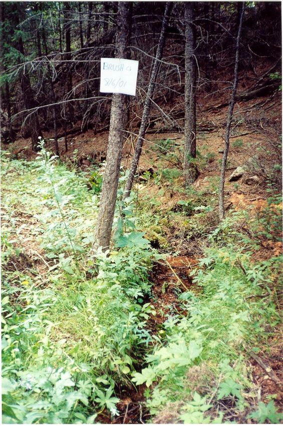
     Catchment Scale
Saloon Gulch and Brush Creek: A Paired Watershed
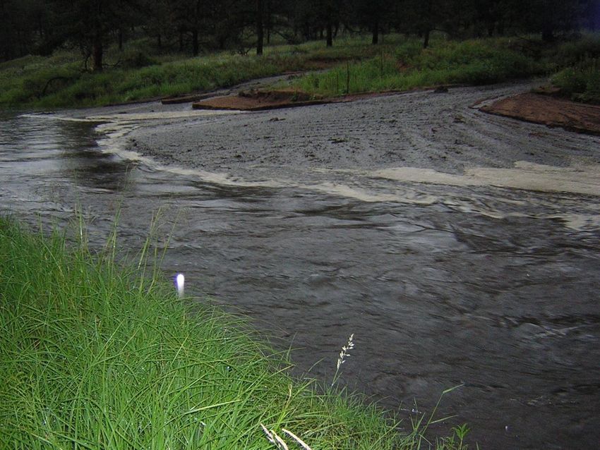
    Study to Investigate the Effects of Thinning
Stream reaches: Summer 2001
Saloon Gulch             Brush Creek
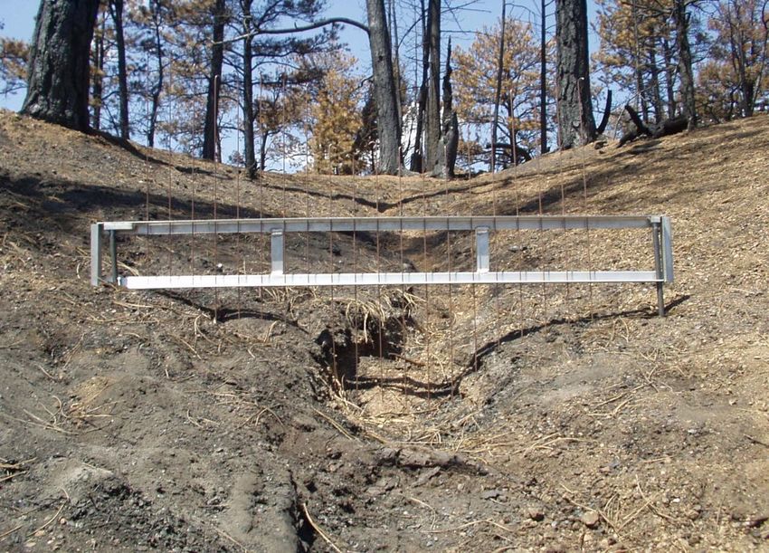
Saloon Gulch flume before Hayman fire
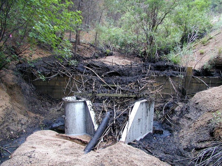
Saloon Gulch flume after first post-fire rainstorm
Saloon Gulch flume cleaned out after
      first post-fire rainstorm
Saloon Gulch flume after second
      post-fire rainstorm
Lower Brush Creek: Upstream of flume
Since runoff rates decline within 2-4 years after burning,
  how long will it take to transport the excess sediment
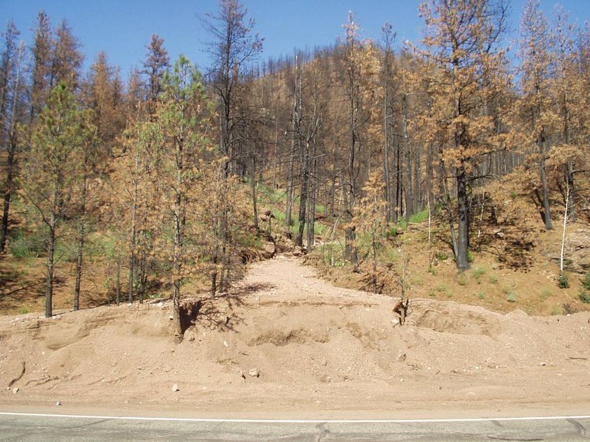
                   out of this channel?
Bobcat fire, 8 years later: How long
 until this becomes a forest again?
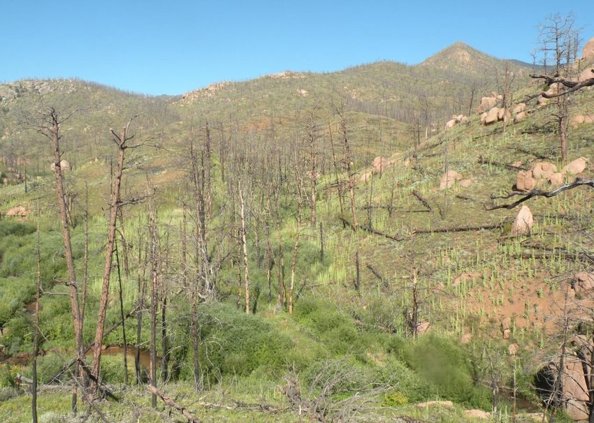
Hayman fire, 7 years later: How long
 until this becomes a forest again?
Hayman fire,
seven years later:
How long until
this stops eroding
and degrading
water quality?
Buffalo Creek fire, 2009
 (13 years after burning)
Hypothetical erosion rates over
                time from different sources
                                             Wildfires
          10
                                             Roads
                                             Thinning
                                             Background
          1
Erosion

          .1

     .01
                            Time
Conclusions: Part 2
• High-severity fires can dramatically increase
  runoff and erosion rates in headwater areas;
• Large sediment deposits in lower-gradient
  channels can result in long-term degradation of
  aquatic habitat;
• For more information, see my web site (type
  “Lee MacDonald” into google).
Questions?
You can also read