EGNOS SAFETY OF LIFE (SOL) - SERVICE DEFINITION DOCUMENT
←
→
Page content transcription
If your browser does not render page correctly, please read the page content below

EGNOS Safety of Life (SoL)
 Service Definition Document

DOCUMENT CHANGE RECORD

Revision    Date         Summary of changes

1.0         02/03/2011   First release of the document

2.0         28/06/2013   •   Update of the document including the improvements derived from
                             the latest EGNOS system releases.
                         •   Alignment with the latest versions of the EGNOS Open Service SDD
                             and the EDAS SDD.

2.1         19/12/2014   •   EGNOS system information updated.
                         •   Update with new commitment maps for ESR2.3.2.
                         •   Observed performance figures updated.
                         •   EGNOS NOTAM proposals updated with current service level provided.
                         •   New appendix D on the impacts of ionospheric activity on GNSS.

2.2         07/04/2015   Figure 4-1 corrected and improvement of commitment maps visibility

3.0         22/09/2015   •   Declaration of LPV-200 service level: Approach operations based on SBAS
                             down to a minimum Decision Height not lower than 200 ft.
                         •   EGNOS Space Segment updated as per EGNOS Service Notice #15.
                         •   New NPA continuity map.
                         •   Update of Appendix D with EGNOS Service Notice #13.

3.1         26/9/2016    •   New SoL commitment maps based on ESR241M
                         •   EGNOS Space Segment updated

                                           2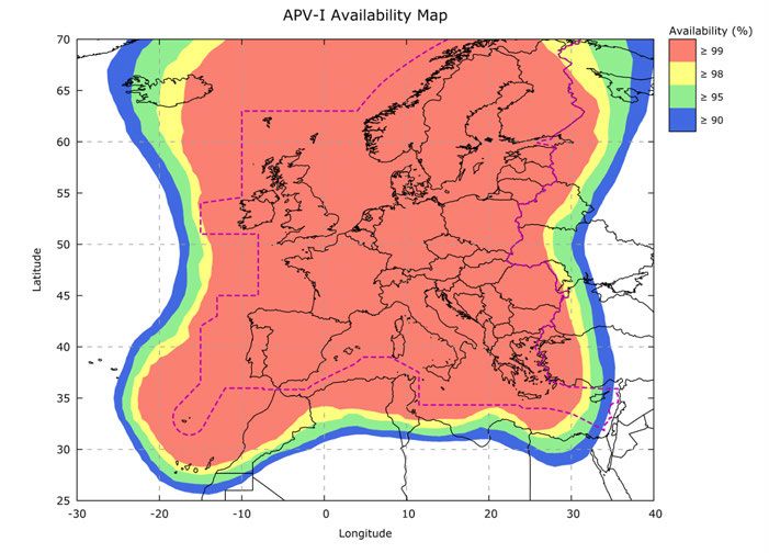
EGNOS Safety of Life (SoL)
                       Service Definition Document

                                                    Precise navigation,
                                                   powered by Europe
The European GNSS Agency produced this document
under tasks entrusted by the European Commission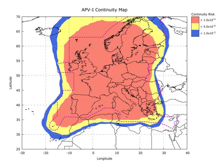
Table of Content

1   EXECUTIVE SUMMARY                                                                                     6
2   INTRODUCTION                                                                                          7
    2.1   PURPOSE AND SCOPE OF THE DOCUMENT                                                               7
    2.2   EGNOS SoL SERVICE DESCRIPTION                                                                   7
    2.3   TERMS AND CONDITIONS OF USE OF EGNOS SAFETY OF LIFE SERVICE, INCLUDING LIABILITY                8
          2.3.1 Scope of the EGNOS Safety of Life Service commitment                                      8
          2.3.2 Who Can Use the EGNOS SoL Service?                                                        8
          2.3.3 Obligations of the Users to Exercise Due Care                                             8
    2.4   EGNOS SoL LIFETIME                                                                              9
    2.5   REFERENCE DOCUMENTS                                                                            10

3   DESCRIPTION OF THE EGNOS SYSTEM AND EGNOS SOL SERVICE
    PROVISION ENVIRONMENT                                                                                11
    3.1   HIGH LEVEL DESCRIPTION OF THE EGNOS TECHNICAL FRAMEWORK                                        11
          3.1.1 Objective of EGNOS                                                                       11
          3.1.2 EGNOS Overview                                                                           11
    3.2   EGNOS ORGANISATIONAL FRAMEWORK                                                                 19
          3.2.1 Bodies Involved in the EGNOS Programme and Service Delivery                              19
          3.2.2 How to Get Information on EGNOS and EGNOS Applications or Contact the Service Provider   19
          3.2.3 EGNOS NOTAM Proposals Generation                                                         21
          3.2.4 EGNOS Working Agreement                                                                  23

4   EGNOS SIS                                                                                            24
    4.1   EGNOS SIS INTERFACE CHARACTERISTICS                                                            24
          4.1.1 EGNOS SIS RF Characteristics                                                             24
          4.1.2 EGNOS SIS Message Characteristics                                                        24
    4.2   EGNOS TIME AND GEODETIC REFERENCE FRAMES                                                       24
          4.2.1 EGNOS Terrestrial Reference Frame – ETRF                                                 24
          4.2.2 EGNOS Network Time: ENT – GPS Time Consistency                                           26
    4.3   EGNOS SIS PERFORMANCE IN THE RANGE DOMAIN                                                      28
          4.3.1 Accuracy in the Range Domain                                                             28
          4.3.1 Integrity in the Range Domain                                                            29

5   EGNOS RECEIVERS                                                                                      30
    5.1   EGNOS RECEIVERS FOR AVIATION                                                                   30
    5.2   RECEIVER & AVIONICS CERTIFICATION                                                              31

6   EGNOS SoL SERVICE PERFORMANCE                                                                        32
    6.1   EGNOS SoL SERVICE DESCRIPTION AND CHARACTERISTICS                                              32
    6.2   EGNOS SoL SERVICE PERFORMANCE REQUIREMENTS                                                     32
    6.3   EGNOS SoL MINIMUM SERVICE PERFORMANCE CHARACTERISTICS                                          34
          6.3.1 NPA - Non Precision Approach                                                             35
          6.3.2 APV-I - Approach With Vertical Guidance                                                  37
          6.3.3 LPV-200                                                                                  40
    6.4   EGNOS SoL SERVICE LIMITATIONS                                                                  43

APPENDIX A SATELLITE NAVIGATION CONCEPT                                                                  45
APPENDIX B EGNOS INTEGRITY CONCEPT                                                                       47
APPENDIX C DEFINITIONS                                                                                   49

                                                   4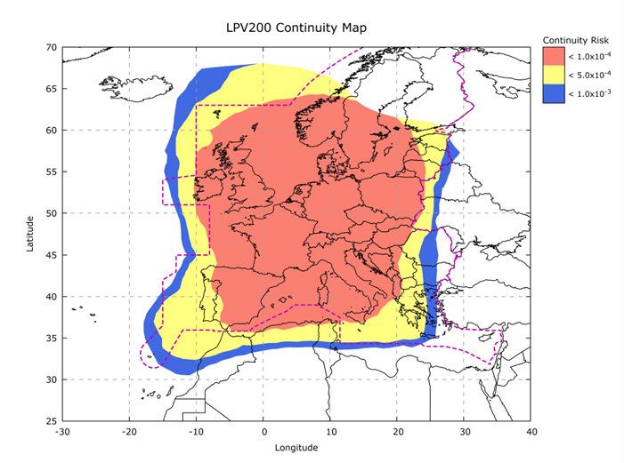
APPENDIX D IONOSPHERIC ACTIVITY AND IMPACT ON GNSS                                                      54
APPENDIX D.1 IONOSPHERE AND GNSS                                                                        54
APPENDIX D.2 IMPACT OF THE IONOSPHERIC ACTIVITY ON GNSS                                                 54
APPENDIX D.3 IMPROVEMENT AND ROBUSTNESS ACHIEVED BY EGNOS                                               56

APPENDIX E LIST OF ACRONYMS                                                                             60
TABLE OF FIGURES
FIGURE 3-1: EDAS HIGH-LEVEL ARCHITECTURE                                                                13
FIGURE 3-2: EXISTING AND PLANNED SBAS SYSTEMS                                                           14
FIGURE 3-3: EGNOS ARCHITECTURE                                                                          15
FIGURE 3-4: EGNOS RIMS SITES                                                                            18
FIGURE 3-5: ESSP NOTAM PROPOSAL SERVICE WITHIN THE NOTAMS LIFE CYCLE                                    21
FIGURE 3-6: THE NOTAM PROCESS                                                                           22
FIGURE 4-1: ENT GPS TIME OFFSET EVOLUTION (PERIOD JANUARY 13 - OCTOBER 15)                              27
FIGURE 6-1: EGNOS NPA AVAILABILITY                                                                      35
FIGURE 6-2: EGNOS NPA CONTINUITY                                                                        36
FIGURE 6-3: EGNOS APV-1 AVAILABILITY                                                                    39
FIGURE 6-4: EGNOS APV-1 CONTINUITY                                                                      39
FIGURE 6-5: EGNOS LPV-200 AVAILABILITY                                                                  41
FIGURE 6-6: EGNOS LPV-200 CONTINUITY                                                                    42
FIGURE 6-7: POSSIBLE SITUATIONS WHEN NAVIGATING WITH EGNOS                                              48
FIGURE 6-8: ECAC 96 FIRS AND EGNOS SERVICE COVERAGE (IN RED)                                            50
FIGURE 6-9: SSN (LEFT) AND AP (RIGHT) PROGRESSION FROM NOAA/SWPC                                        55
FIGURE 6-10: EGNOS LPV PERFORMANCE RESULTS ON 19TH (LEFT) AND 27TH (RIGHT) FEBRUARY 2014                56
FIGURE 6-11: EGNOS APV-I AVAILABILITY ON 12TH SEPTEMBER 2014 WITH ESR 2.3.2 (LEFT) ESR 2.4.1M (RIGHT)   57
FIGURE 6-12: EGNOS APV-I AVAILABILITY ON 19TH SEPTEMBER 2014 WITH ESR 2.3.2 (LEFT) ESR 2.4.1M (RIGHT)   57
FIGURE 6-13: EGNOS LPV AVAILABILITY DURING “SPRING” (LEFT) AND “SUMMER” (RIGHT) PERIODS                 58
FIGURE 6-14: EGNOS LPV CONTINUITY DURING “SPRING” (LEFT) AND “SUMMER” (RIGHT) PERIODS                   58

TABLE OF TABLES
TABLE 3-1: GEOS USED BY EGNOS                                                                           16
TABLE 3-2: WHERE TO FIND INFORMATION ABOUT EGNOS                                                        20
TABLE 4-1: EGNOS SIS TRANSMITTED MTS                                                                    25
TABLE 4-2: TYPICAL EGNOS AND GPS STAND-ALONE SIS UERE                                                   28
TABLE 5-1: EGNOS EQUIPMENT OPERATIONAL CLASSES                                                          30
TABLE 5-2: EXISTING ETSOS AND HARDWARE REQUIREMENTS FOR SBAS OPERATIONS                                 31
TABLE 6-1: SOL SERVICE PERFORMANCE REQUIREMENTS (ICAO)                                                  33
TABLE 6-2: EGNOS SOL SERVICE PERFORMANCE VALUES                                                         34
TABLE 6-3: APV-1 ACCURACY                                                                               38
TABLE 6-4: LPV-200 ACCURACY                                                                             40
TABLE 6-5: EGNOS SOL LIMITATIONS                                                                        43
TABLE 6-6: RTCA MOPS C&D TERMINOLOGY DIFFERENCES FOR NAVIGATION MODE                                    52

                                                      5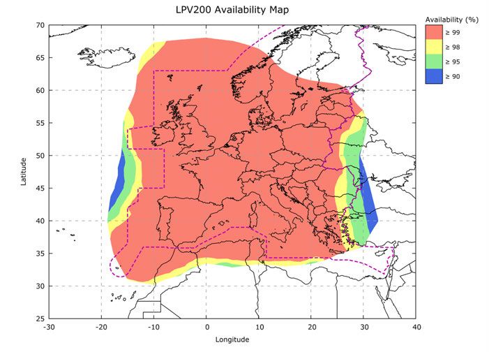
1 Executive Summary

 The European Geostationary Navigation Overlay Service                 performance achieved, and provides information on the
 (EGNOS) provides an augmentation service to the                       established technical and organisational framework, at
 Global Positioning System (GPS) Standard Positioning                  European level, for the provision of this service. It is
 Service (SPS). Presently, EGNOS augments GPS using                    intended to be of use for Air Navigation Service Providers
 the L1 (1575,42 MHz) Coarse/Acquisition (C/A) civilian                (ANSPs), receiver manufacturers, equipment integrators,
 signal function by providing correction data and integrity            airlines, operators, GNSS application developers and the
 information for improving positioning, navigation and                 final users of the EGNOS SoL Service.
 timing services over Europe.
                                                                       The document includes also complementary high level
 The EGNOS Safety of Life (SoL) Service is provided openly             information on GNSS concepts, the GPS Service, the EGNOS
 and is freely accessible without any direct charge, and is            System/Services, the EGNOS Management structure and
 tailored to safety-critical transport applications in various         EGNOS interfaces with users, as well as the minimum
 domains, in particular for aviation applications. The service         performance characteristics of the EGNOS SoL Service.
 is thus compliant with the aviation requirements for
 Approaches with Vertical Guidance (APV-I) and Category                This document is not intended to address EGNOS Open
 I precision approaches1, as defined by ICAO in Annex 10               Service (OS) nor EDAS performance. Information about
 [RD-6]. The operational use of the EGNOS SoL Service may              the EGNOS OS is available in a separate document called
 require specific authorisation by the relevant authorities            the “EGNOS Open Service - Service Definition Document”
 in the application sectors concerned.                                 (EGNOS SDD OS - [RD-10]), whilst information regarding
                                                                       EDAS can be found in another separate document called
 This version of the “EGNOS SoL Service Definition                     the “EGNOS Data Access Service (EDAS) – Service Definition
 Document” (EGNOS SoL SDD) is intended to give                         Document” (EDAS SDD – [RD-11]).
 information on the EGNOS SoL Service.
                                                                       This document will be updated in the future as required
 The document describes the EGNOS system architecture                  in order to reflect any changes and improvements to the
 and Signal-In-Space (SIS) characteristics, the SoL service            EGNOS SoL Service.

 1. According to the new ICAO approach classification following the ICAO State Letter Ref.: AN 11/1.1-12/40, 29 June 2012, LPV-200 enables
    approach procedures designed for 3D instrument approach operations Type A or Type B (as also stated in ICAO Annex 6).

                                                                  6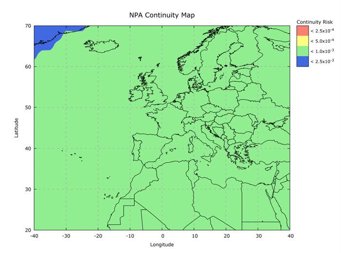
2 Introduction

 2.1 Purpose and Scope                                          •   Section 6 (“EGNOS SoL Service Performance”)
 of the Document                                                    describes the positioning Service offered to users
                                                                    by the EGNOS SoL Service and the minimum perfor-
 The EGNOS Safety of Life SDD (EGNOS SoL SDD) presents              mance in the positioning domain.
 the characteristics of the service offered to users by EGNOS   •   Appendix A contains fundamental information of
 Safety of Life (SoL) Service highlighting the positioning          the satellite navigation (GNSS) as complementary
 performance currently available to suitably equipped               concepts for the rest of the documents.
 users using both the GPS SPS broadcast signal and the          •   Appendix B describes the integrity concept used in
 EGNOS SoL augmentation signals.                                    EGNOS.
                                                                •   Appendix C presents relevant definitions.
 The minimum level of performance of the EGNOS SoL              •   Appendix D assesses the impact of the ionospheric
 Service as specified in the EGNOS SoL SDD is obtained              activity on GNSS and in particular on SBAS systems.
 under the condition that compliance is ensured with:           •   Appendix E provides the list of acronyms used in
                                                                    the document.
 •   The main GPS SPS SIS characteristics and performance
     defined in the GPS ICD [RD-9], in SBAS MOPS appen-         This document does not address the Open Service (OS)
     dix B [RD-7] and in GPS SPS Performance Standard           and the EGNOS Data Access Service (EDAS), which are
     [RD-8] and;                                                described in separate dedicated Service Definition
 •   The receiver characteristics as described in sections      Documents.
     3 and 4.

 The EGNOS SoL SDD comprises 6 main sections and 5              2.2 EGNOS SoL Service
 appendixes:                                                    Description
 •   Section 1 is an Executive Summary of the document.         The EGNOS SoL Service consists of signals for timing and
 •   Section 2 (“Introduction”) defines the scope of the        positioning intended for most transport applications in
     document and the relevant reference documentation.         different domains. Nevertheless, navigation operations
     In addition, this section clarifies the terms and con-     based on the EGNOS SoL Service may require a specific
     ditions of EGNOS SoL Service use, including liability,     authorisation, issued by the relevant authority, unless
     and its intended lifetime.                                 the authority, or applicable regulation, establishes that
 •   Section 3 (“Description of the EGNOS System and            no such authorisation is required.
     EGNOS SoL Service Provision Environment”) gives a
     brief overview of the EGNOS system, as well as its         The SoL service is based on integrity data provided through
     technical and organisational framework for EGNOS           the EGNOS satellite signals.
     SoL service provision.
 •   Section 4 (“EGNOS SIS”) introduces the EGNOS Sig-          The main objective of the EGNOS SoL service is to support
     nal In Space characteristics and performance in the        civil aviation operations down to LPV (Localiser Perfor-
     range domain.                                              mance with Vertical guidance) minima. However, the SoL
 •   Section 5 (“EGNOS Receivers”) briefly presents the         Service is also intended to support applications in a wide
     certification context for aviation receivers.              range of other domains such as maritime, rail and road.

                                                                7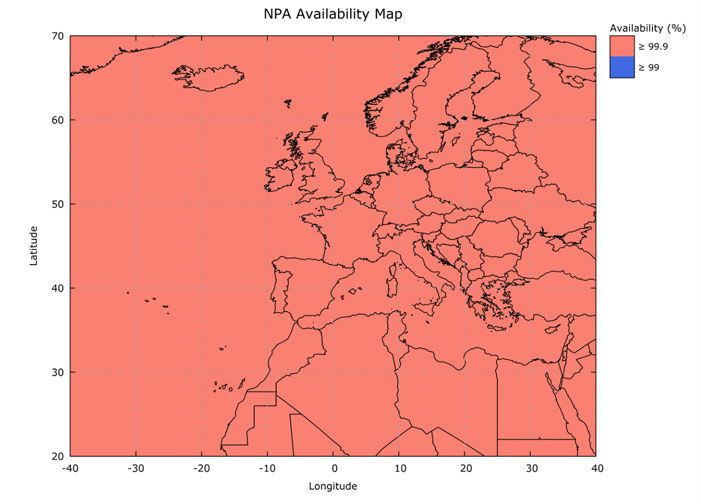
SAFET Y OF LIFE | SERVICE DEFINITION DOCUMENT

2.3 Terms and Conditions of                                             may require a specific authorisation, issued by the relevant
Use of EGNOS Safety of Life                                             authority, unless the authority, or applicable regulation,

Service, Including Liability                                            establishes that no such authorisation is required.

                                                                        At the date of EGNOS SoL SDD publication, only the avi-
2.3.1 SCOPE OF THE EGNOS SAFETY OF                                      ation domain has specific service requirements, as well
LIFE SERVICE COMMITMENT                                                 as certification and individual authorisation procedures
                                                                        developed and implemented.
The EGNOS Safety of Life service (further “EGNOS SoL
Service”) comprises the provision of an augmentation                    Therefore, from the date of EGNOS SoL SDD publication
signal to the Global Positioning System (GPS) Standard                  the EGNOS SoL Service is tailored for use in aviation, for
Positioning Service (SPS) with the specific committed                   all phases of flight within the corresponding EGNOS SoL
performance and subject to the service limitations                      Service area, to aviation users (further “Aviation Users”)
described here in the EGNOS SoL Service Definition                      namely:
Document (further “EGNOS SoL SDD”).
                                                                        •    Airspace users, as defined in the Single European
Only minimum performance characteristics are                                 Sky (SES) framework Regulation2, equipped with
included in the commitment even though the users                             an EGNOS certified receiver and located within the
can usually experience a better performance. These                           appropriate EGNOS SoL Service area corresponding
characteristics are expressed in statistical values under                    to the phase of flight in which the EGNOS SoL Service
given assumptions.                                                           is used (as described in the EGNOS SoL SDD);
                                                                        •    Certified Air Navigation Service Providers (ANSP)
                                                                             having signed an EGNOS Working Agreement with
2.3.2 WHO CAN USE                                                            the European Satellite Services Provider (ESSP SAS),
THE EGNOS SoL SERVICE?                                                       the certified EGNOS Services Provider, that is valid
                                                                             at the moment of the use of the EGNOS SoL Service.
In general, the EGNOS SoL Service is intended for most
transport applications in different domains where lives
could be endangered if the performance of the navigation                2.3.3 OBLIGATIONS OF THE USERS
system is degraded below specific accuracy limits without               TO EXERCISE DUE CARE
giving notice in the specified time to alert. This requires
that the relevant authority of the particular transport                 EGNOS is a complex technical system and the users also
domain determines specific requirements for the naviga-                 have certain obligations to exercise due care in using the
tion service based on the needs of that domain, as well                 EGNOS SoL Service. Before any use of the EGNOS SoL
as certification procedures if necessary. In addition, the              Service, all users should study this document in order to
navigation operations based on the EGNOS SoL Service                    understand whether and how they can use the service,

2. Regulation (EC) No 1070/2009 (revision and extension of Regulation No 549/2004) of the European Parliament and of the Council of October
   21 2009 aiming at increasing the overall performance of the air traffic management system in Europe (SES II Package).

                                                                  8
DISCLAIMER OF LIABILITY
  The European Union, as the owner of EGNOS system,               Furthermore, no party shall be entitled to any claim
  the European GNSS Agency (GSA) as EGNOS Programme               against ESSP SAS and/or the European Union and/or the
  manager and ESSP SAS, as EGNOS services provider,               GSA if the damage is the result, or the consequence, of
  expressly disclaim all warranties of any kind (whether          any of the following events:
  expressed or implied) to any party, other than Aviation
  Users specified under 2.3.2 above, and/or for any other         •   Use of EGNOS SoL Service beyond the conditions
  use of the EGNOS SoL Service including, but not lim-                and limitations of use set forth in the EGNOS SoL
  ited to the warranties regarding availability, continuity,          SDD, it being understood that the use of EGNOS
  accuracy, integrity, reliability and fitness for a particular       SoL by users other than Aviation Users constitutes
  purpose or meeting the users´ requirements. No advice               a use beyond such conditions and limitations, or
  or information, whether oral or written, obtained by a          •   Use of equipment or receivers which are
  user from the European Union, GSA or ESSP SAS and                    - not fully compliant to MOPS (Minimum Oper-
  its business partners shall create any such warranty.                  ational Performance Standards for Global Posi-
                                                                         tioning System/Wide Area Augmentation System
  By using the EGNOS SoL Service, the Aviation Users                     Airborne Equipment) or
  agree that neither the European Union nor GSA nor ESSP               - not certified or approved by the relevant com-
  SAS shall be held responsible or liable for any indirect,              petent authority or
  special or consequential damages, including but not                  - malfunctioning, or
  limited to, damages for interruption of business, loss          •   Use of the EGNOS SoL Service when a test message
  of profits, goodwill or other intangible losses, resulting          is broadcast (a Message Type 0 or a Message Type
  from the use of, misuse of, or the inability to use the             0/2), or
  EGNOS SoL Service.                                              •   Use of the EGNOS SoL Service without required
                                                                      authorisation, or
                                                                  •   In case of a Force Majeure event.

as well as to familiarise themselves with the performance         2.4 EGNOS SoL Lifetime
level and other aspects of the service they can rely on.
                                                                  The EGNOS Services are intended to be provided for a
In case of doubt, the users and other parties should con-         minimum period of 20 years, as from its first declaration
tact the EGNOS helpdesk (see section 3.2.2 for contact            date, with 6 years advance notice in case of significant
details). Aviation Users may also contact their National          changes in the Services provided.
Supervisory Authority (NSA).

                                                                  9
SAFET Y OF LIFE | SERVICE DEFINITION DOCUMENT

2.5 Reference Documents

    RD                                                Document Title

   [RD-1]   ICAO Standards and Recommended Practices (SARPS) Annex10 Volume I (Radio Navigation Aids)
   [RD-2]   RTCA MOPS DO 229 (Revisions C or D Change 1)
   [RD-3]   GPS Standard Positioning Service Performance Standard – 30th September 2008 4th Edition
   [RD-4]   IS GPS 200 Revision H – NAVSTAR GPS Space Segment / Navigation User Interface – 24th
            September 2013
   [RD-5]   EGNOS Service Definition Document – Open Service (OS SDD)
            http://egnos-portal.gsa.europa.eu/library/technical-documents
   [RD-6]   EGNOS Data Access Service – Service Definition Document (EDAS SDD)
            http://egnos-portal.gsa.europa.eu/library/technical-documents
   [RD-7]   REGULATION (EU) No 1285/2013 OF THE EUROPEAN PARLIAMENT AND OF THE COUNCIL of
            11 December 2013 on the implementation and exploitation of European satellite navigation
            systems and repealing Council Regulation (EC) No 876/2002 and Regulation (EC) No 683/2008 of
            the European Parliament and of the Council
   [RD-8]   Single European Sky (SES) regulatory requirement RE (CE) 1070/2009 (revision and extension of
            EC 550/2004)
   [RD-9]   COMMISSION IMPLEMENTING REGULATION (EU) No 1035/2011 laying down common
            requirements for the provision of air navigation services and amending Regulations
            (EC) No 482/2008 and (EU) No 691/2010
  [RD-10]   EC/ESA/CNES User Guide for EGNOS Application Developers Ed. 2.0 – 15th December 2011
  [RD-11]   ICAO Standards and Recommended Practices (SARPS) Annex 15 Aeronautical Information
            Services
  [RD-12]   The European Concept for GNSS NOTAM, V2.7 (Eurocontrol GNSS NOTAM CONOPS), 29th
            November 2011
  [RD-13]   ICAO Standards and Recommended Practices (SARPS) Annex 6, Operation of Aircraft
  [RD-14]   ICAO Standards and Recommended Practices (SARPS) Annex 14, Aerodromes
  [RD-15]   ICAO Doc 8168, Aircraft Operations (PANS-OPS)
            Volume I — Flight Procedures
            Volume II — Construction of Visual and Instrument Flight Procedures
  [RD-16]   EASA AMC 20-28 “Airworthiness Approval and Operational Criteria related to Area Navigation
            for Global Navigation Satellite System approach operation to Localiser Performance with Vertical
            guidance minima using Satellite Based Augmentation System”, Effective: 24/09/2012
  [RD-17]   ICAO Doc 9613, Performance-based Navigation (PBN) Manual
  [RD-18]   ICAO Doc 9849 – Global Navigation Satellite System (GNSS) Manual

                                                 10
3 Description of the EGNOS System and
EGNOS SoL Service Provision Environment
3.1 High Level Description of the The reader is invited to read Appendix A for background
EGNOS Technical Framework information about the Satellite Navigation Concept.
3.1.1 OBJECTIVE OF EGNOS 3.1.2 EGNOS OVERVIEW
Satellite navigation systems are designed to provide a 3.1.2.1 EGNOS Services
positioning and timing service over vast geographical areas EGNOS provides corrections and integrity information to
(typically continental or global coverage) with high accuracy GPS signals over a broad area centred over Europe and
performance. However, a number of events (either internal it is fully interoperable with other existing SBAS systems.
to the system elements or external, due to environmental
conditions) may lead to positioning errors that are in excess EGNOS provides three services:
of the typically observed navigation errors. For a large vari-
ety of users, such errors will not be noticed or may have • Open Service (OS), freely available to any user;
a limited effect on the intended application. However, for • Safety of Life (SoL) Service, that provides the most
safety critical applications, they may directly impact the stringent level of signal-in-space performance to all
safety of operations. Therefore, there is an absolute need Safety of Life user communities;
to correct such errors, or to warn the user in due time when • EGNOS Data Access Service (EDAS) for users who
such errors occur and cannot be corrected. For this reason, require enhanced performance for commercial and
augmentation systems have been designed to improve the professional use.
performance of existing global constellations.
All of these EGNOS services are available and granted
EGNOS is a Satellite Based Augmentation System (SBAS). throughout their respective service areas.
SBAS systems are designed to augment the navigation
system constellations by broadcasting additional signals Open Service (OS)
from geostationary (GEO) satellites. The basic scheme is The main objective of the EGNOS OS is to improve the
to use a set of monitoring stations (at very well-known achievable positioning accuracy by correcting several error
position) to receive GPS signals that will be processed in sources affecting the GPS signals. The corrections trans-
order to obtain some estimations of these errors that are mitted by EGNOS contribute to mitigate the ranging error
also applicable to the users (i.e. ionospheric errors, sat- sources related to satellite clocks, satellite position and
ellite position/clock errors, etc.). Once these estimations ionospheric effects. The other error sources (tropospheric
have been computed, they are transmitted in the form effects, multipath and user receiver contributions) are local
of “differential corrections” by means of a GEO satellite. effects that cannot be corrected by a global augmentation
Today, EGNOS augments GPS signals. system. Finally, EGNOS can also detect distortions affecting
the signals transmitted by GPS and prevent users from
Along with these correction messages which increase tracking unhealthy or misleading signals.
accuracy, some integrity data for the satellites that are in
the view of this network of monitoring stations are also The EGNOS OS is accessible in Europe to any user equipped
broadcast, increasing the confidence that a user can have with an appropriate GPS/SBAS compatible receiver for
in the satellite navigation positioning solution. which no specific receiver certification is required.
11SAFET Y OF LIFE | SERVICE DEFINITION DOCUMENT
The EGNOS OS has been available since 1st October 2009 • Category I precision approach with a Vertical Alert
and the corresponding SDD is [RD-5]. Limit (VAL) equal to 35m and supporting RNP APCH
PBN navigation specification down to LPV minima
Safety of Life Service (SoL) as low as 200 ft.
The main objective of the EGNOS SoL service is to support
civil aviation operations down to Localiser Performance EGNOS Data Access Service (EDAS)
with Vertical Guidance (LPV) minima. At this stage, a EDAS is the EGNOS terrestrial data service which offers
detailed performance characterisation has been con- ground-based access to EGNOS data in real time and
ducted only against the requirements expressed by civil also in a historical FTP archive to authorised users (e.g.
aviation but the EGNOS SoL service might also be used added-value application providers). EDAS is the single
in a wide range of other application domains (e.g. mar- point of access for the data collected and generated by
itime, rail, road…) in the future. In order to provide the the EGNOS ground infrastructure (RIMS and NLES mainly)
SoL Service, the EGNOS system has been designed so that distributed over Europe and North Africa.
the EGNOS Signal-In-Space (SIS) is compliant to the ICAO
SARPs for SBAS [RD-1]. Application Providers will be able to connect to the EGNOS
Data Server, and exploit the EGNOS products, offering
The EGNOS SoL Service has been available since March high-precision services3 to final customers.
2nd 2011 being this document the applicable SDD.
The EGNOS EDAS is available since July 26th 2012 and the
Two EGNOS SoL Service levels (NPA and APV-I) were corresponding SDD is [RD-6].
declared with the first issue of the EGNOS SoL SDD v1.0 in
March 2011 and an additional one (LPV-200) was declared
with the EGNOS SoL SDD v3.0 in September 2015 enabling
the following SBAS-based operations in compliance with
requirements as defined by ICAO in Annex 10 [RD-1]:
• Non-Precision Approach operations and other flight
operations supporting PBN navigation specifications
other than RNP APCH, not only for approaches but
also for other phases of flight.
• Approach operations with Vertical Guidance support-
ing RNP APCH PBN navigation specification down to
LPV minima as low as 250 ft.
3. Examples of potential applications that could be provided are: EGNOS pseudolites; provision of EGNOS services through RDS, DAB, Internet;
accurate ionospheric delay/TEC maps; provision of RIMS data; provision of performance data (e.g. XPL availability maps, GIVE maps, etc.);
provision of EGNOS message files.
12Figure 3-1 EDAS High-Level Architecture
EGNOS GEO
GPS/GLONASS GPS/GLONASS
SERVICE
PROVIDERS
INTERNET INTERNET EDAS
FINAL
RF/GSM USERS
EWAN INTERNET
EDAS
USERS
EGNOS STATIONS EDAS INTERNET
NETWORK
13SAFET Y OF LIFE | SERVICE DEFINITION DOCUMENT
3.1.2.2 EGNOS: The European SBAS
EGNOS is part of a developing multi-modal inter-regional • WAAS, Federal Aviation Administration (FAA):
SBAS service, able to support a wide spectrum of http://www.faa.gov/about/office_org/
applications in many different user communities, such headquarters_offices/ato/service_units/techops/
as aviation, maritime, rail, road, agriculture. Similar navservices/gnss/
SBAS systems, designed according to the same standard • SDCM, Federal Space Agency (“Roscosmos”):
(i.e. SARPs [RD-1]), have already been commissioned by http://www.sdcm.ru/index_eng.html
the US (Wide Area Augmentation System – WAAS) and • MSAS, Japanese Ministry of Land, Infrastructure,
Japan (MTSAT Satellite based Augmentation System – Transport and Turism (MLIT):
MSAS). Analogous systems are under commissioning http://www.mlit.go.jp/
or deployment in other regions of the world (e.g. GPS • GAGAN, Indian Space Research Organisation
Aided GEO Augmented Navigation – GAGAN in India and (ISRO):
System of Differential Correction and Monitoring – SDCM http://www.isro.org/applications/satellite-
in Russia). The worldwide existing and planned SBAS navigation-programme
systems are shown in Figure 3-2.
In addition, most of these systems have plans to extend
For additional information, the reader is invited to visit their service areas to neighbouring regions, thus paving
the following websites: the way for near global SBAS coverage.
Figure 3-2 Existing and planned SBAS systems
SDCM
EGNOS
WAAS
MSAS
GAGAN
143.1.2.3 EGNOS Architecture
The EGNOS functional architecture is shown in Figure 3-3:
In order to provide its services to users equipped with
appropriate receivers, the EGNOS system comprises two
main segments: the Space Segment, and the Ground
Segment.
Figure 3-3 EGNOS architecture
GEO GPS
Space Segment
User Segments RIMS
NLES Ranging &
Navigation Integrity
Ground Segment
Land Earth Monitoring
Stations Stations
EWAN (EGNOS Wide Area Network)
MCC PACF Performance Assessment
and Check-out Facility
Mission
Control ASQF Application Specific
Centres Qualification Facility
15SAFET Y OF LIFE | SERVICE DEFINITION DOCUMENT
EGNOS Space Segment
The EGNOS Space Segment comprises 4 geostationary link to benefit from the EGNOS Services, this secures a
(GEO) satellites broadcasting corrections and integrity switching capability in case of interruption and ensures
information for GPS satellites in the L1 frequency band a high level of continuity of service.
(1575,42 MHz). At the date of publication the 4 GEOs
used by EGNOS are (see Table 3-1): It is intended that the EGNOS space segment will be
replenished over time in order to maintain a similar
EGNOS GEO satellites SES-5 (PRN 136) and INMARSAT level of redundancy. The exact orbital location of future
3F2 AOR-E (PRN 120) are currently part of the EGNOS satellites may vary, though this will not impact the
operational platform and are transmitting the operational service offered to users. Similarly, different PRN code
Signal-In-Space (SIS) to be used by EGNOS users. ASTRA-5B numbers may be assigned to future GEOs. It is important
(PRN 123) and INMARSAT 4F2 EMEA (PRN 126) are part to remark that these changes in the EGNOS GEO space
of the EGNOS TEST Platform broadcasting the TEST SIS. segment are performed in a seamless manner without
any interruption from an EGNOS user point of view
This space segment configuration provides a high level and without compromising at any moment the EGNOS
of redundancy over the whole service area in case of a performances. For this purpose, and whenever there could
geostationary satellite link failure. The EGNOS operations be any relevant information complementing the SDD, an
are handled in such a way that, at any point in time, at EGNOS Service Notice is published (http://egnos-user-
least two of the four GEOs broadcast an operational signal. support.essp-sas.eu/new_egnos_ops/content/service-
Since it is only necessary to track a single GEO satellite notices) and distributed.
Table 3 1 GEOs used by EGNOS
GEO Name PRN Number Orbital Slot
INMARSAT 3F2 AOR-E PRN 120 15.5 W
ASTRA SES-5 PRN 136 5E
INMARSAT 4F2 EMEA PRN 126 64 E
ASTRA-5B PRN 123 31.5 E
16EGNOS Ground Segment geostationary broadcast area. However, due to
the geographical distribution of the EGNOS ground
The EGNOS Ground Segment comprises a network of monitoring network, the accuracy of these corrections
Ranging Integrity Monitoring Stations (RIMS), two Mis- will degrade when moving away from the core of the
sion Control Centres (MCC), six Navigation Land Earth EGNOS service area.
Stations (NLES), and the EGNOS Wide Area Network
(EWAN) which provides the communication network for 3. Elaborate a model for ionospheric errors over the
all the components of the ground segment. Two addi- EGNOS service area in order to compensate for ion-
tional facilities are also deployed as part of the ground ospheric perturbations to the navigation signals.
segment to support system operations and service provi-
sion, namely the Performance Assessment and Checkout This function requires a dense network of monitoring
Facility (PACF) and the Application Specific Qualification stations. For this reason, the ionospheric model broadcast
Facility (ASQF), which are operated by the EGNOS Service by EGNOS is not available for the whole geostationary
Provider (ESSP SAS). broadcast area but is only provided for a region centred
over Europe.
• Ranging Integrity Monitoring Stations (RIMS)
The main function of the RIMS is to collect measurements These three sets of corrections are then broadcast to
from GPS satellites and to transmit these raw data every users to improve positioning accuracy.
second to the Central Processing Facilities (CPF) of each
MCC. The current RIMS network comprises 39 RIMS sites In addition, the CPF estimates the residual errors that can
located over a wide geographical area. be expected by the users once they have applied the set
of corrections broadcast by EGNOS. These residual errors
Figure 3-4 shows the geographical distribution of the are characterised by two parameters:
deployed RIMS (in grey the ones not yet contributing to
the EGNOS solution). • User Differential Range Error (UDRE): this is an
estimate of the residual range error after the
• Central Processing Facility (CPF) application of clock and ephemeris error correction
The Central Processing Facility (CPF) is a module of the for a given GPS satellite.
MCC that uses the data received from the network of • Grid Ionospheric Vertical Error (GIVE): this is an
RIMS stations to: estimate of the vertical residual error after application
of the ionospheric corrections for a given geographical
1. Elaborate clock corrections for each GPS satellite grid point.
in view of the network of RIMS stations. These
corrections are valid throughout the geostationary These two parameters can be used to determine an aggre-
broadcast area (i.e. wherever the EGNOS signal is gate error bounded by the horizontal and vertical position
received). errors. Such information is of special interest for Safety of
Life users but may also be beneficial to other communities
2. Elaborate ephemeris corrections to improve the needing to know the uncertainty in the position deter-
accuracy of spacecraft orbital positions. In principle, mined by the user receiver. More details on the EGNOS
these corrections are also valid throughout the integrity concept can be found in Appendix B.
17SAFET Y OF LIFE | SERVICE DEFINITION DOCUMENT
Figure 3-4 EGNOS RIMS sites
LYR MON
KOU
JME
HBK
KIR
TRO
RKK EGI MON
TRD
GVL LAP
KOU
ALB
GLG
BRN WRS
CRK
SWA
PAR
ZUR
SDC TLS SOF
ROM
PDM GOL
ACR LSB
ATH
CTN
MLG
DJA
MAD HFA
ALY
AGA
LPI
CNR
ABS
NOU
18Finally, the CPF includes a large number of monitoring The European Space Agency (ESA) led the technical
functions designed to detect any anomaly in GPS and in the development of the EGNOS system in the past and is now
EGNOS system itself and is able to warn users within a very mandated by the European Commission to be responsible
short timeframe (less than Time To Alert (TTA)) in case of for:
an error exceeding a certain threshold. These monitoring a) conception, design, monitoring, procurement and
functions are tailored to the Safety of Life functions and validation in the framework of the development of
will not be further detailed in this document. future generations of the systems;
b) technical support in the framework of operation
• Navigation Land Earth Stations (NLES) and maintenance of the existing generation of the
The messages elaborated by the CPF are transmitted to systems.
the NLESs. The NLESs (two for each GEO for redundancy
purposes) transmit the EGNOS message received by the The European Satellite Services Provider (ESSP) SAS is the
CPF to the GEO satellites for broadcast to users and to EGNOS Services Provider within Europe, certified according
ensure the synchronisation with the GPS signal. to the Single European Sky (SES) regulation as Air Navigation
Service Provider (ANSP). ESSP SAS provides the EGNOS
• Central Control Facility (CCF) OS, EDAS Services and SoL Service compliant with ICAO
The EGNOS system is controlled through a Central Control (International Civil Aviation Organization) Standards and
Facility (CCF) located in each of the Mission Control Cen- Recommended Practices throughout the European Civil
tres. These facilities are manned on a 24/7 basis in order Aviation Conference (ECAC) region. ESSP SAS as EGNOS
to ensure permanent service monitoring and control. service provider also generates EGNOS Notice To Airmen
(NOTAM) proposals to the appropriate Aeronautical Infor-
mation Service providers within Europe that should validate
and distribute the final Official EGNOS NOTAM.
3.2 EGNOS Organisational
Framework ESSP SAS has been awarded the operations and services
provision contract by GSA for EGNOS until the end of 2021.
3.2.1 BODIES INVOLVED IN THE EGNOS
PROGRAMME AND SERVICE DELIVERY 3.2.2 HOW TO GET INFORMATION ON
EGNOS AND EGNOS APPLICATIONS OR
The European Union (EU) is the owner of the EGNOS CONTACT THE SERVICE PROVIDER
system. The European GNSS Agency (GSA), according
to the delegation agreement with the European A number of websites and e-mail addresses are made
Commission (EC), is in charge of the tasks associated available by the EC, GSA, ESA ESSP SAS and other
with the exploitation phase of EGNOS, overall EGNOS organisations to provide detailed information on the
operational programme management and as such, is EGNOS programme, the system status and system
responsible for taking decisions regarding the system performance, as well as a number of useful tools.
exploitation, evolutions and promotion of the services Table 3-2 below lists the main sources of information
and applications. about EGNOS.
19SAFET Y OF LIFE | SERVICE DEFINITION DOCUMENT
EGNOS SoL SDD readers are also invited to refer to the meets the ICAO Annex 10, Standards and Recommended
GPS SPS PS [RD-3] and European Aviation Safety Agency Practices (SARPs) for Global Navigation Satellite System
(EASA) European Technical Standard Order (ETSO)-145/146 (GNSS) Satellite Based Augmentation System (SBAS),
for details of both the fundamental GPS SPS service and [RD-1], except for the continuity requirements where
EGNOS receiver equipment respectively. EGNOS also some waivers exist as detailed in section 6.3.1.4 for NPA
Table 3-2 Where to find information about EGNOS
Topic Organisation Web/contact details
EGNOS Programme EC http://ec.europa.eu/growth/sectors/space/
EC institutional information about the EGNOS egnos/index_en.htm
Programme
EGNOS general information GSA http://www.egnos-portal.eu
and EGNOS applications
EGNOS Service provider activity ESSP http://www.essp-sas.eu
ESSP official reporting of the service provider
activities, news etc.
EGNOS User Support ESSP http://egnos-user-support.essp-sas.eu/
ESSP dedicated service to users on EGNOS
status and performance, system description,
real time services performances, forecasts,
EGNOS applicable documentation, FAQs, etc.
A specific EDAS section is also available.
EGNOS Helpdesk ESSP egnos-helpdesk@essp-sas.eu
Direct point of contact for any question +34 911 236 555
related with the EGNOS system, its
performances and applications.
EGNOS System ESA http://www.esa.int/esaNA/egnos.html
ESA dedicated services and detailed technical
information on EGNOS
EGNOS certified receivers EASA egnos@easa.europa.eu
EASA mailbox for any question related to
service difficulties or malfunctions of EGNOS
certified receivers
EDAS GSA/EC/ESSP http://www.gsa.europa.eu/egnos/edas
General information about EDAS
EGNOS Working Agreements (EWA) ESSP EGNOS-working-agreement@essp-sas.eu
Formalization between ESSP and a specific
ANSP for introducing EGNOS LPV approaches
within the associated country.
20service level, in section 6.3.2.5 for APV-I service level and SARPs ([RD-11]). Apart from establishing the NOTAM
in section 6.3.3.5 for LPV-200 service level. service as a key element in the implementation of SBAS
based approach procedures, the ICAO SARPs also lay down
the applicable recommendations for this kind of service,
3.2.3 EGNOS NOTAM PROPOSALS in terms of notification timeliness.
GENERATION
Since the 2nd of March 2011 (EGNOS SoL Service Decla-
A NOTAM (Notice to Airmen) is a notice issued to alert ration date), the ESSP, as the EGNOS Services Provider, is
pilots of potential hazards along a flight route that could providing the EGNOS NOTAM proposals service, through
affect the safety of the flight. the corresponding national AIS provider, to any airport
having an EGNOS based approach procedure published.
The objective of the EGNOS NOTAM proposal generation Hence, the ESSP acts as data originator in the EGNOS
is to: NOTAM generation chain. In particular, ESSP provides
NOTAM proposals to the corresponding national NOTAM
• Predict APV-I and LPV-200 services outages at given Offices (AIS provider) of the concerned States, which are
airports. responsible for the validation and publication of NOTAMs
• Create and format the corresponding NOTAM for end users.
proposals into an ICAO format [RD-11] and according
to the European Concept for GNSS NOTAM [RD-12] Please note that, apart from the EGNOS NOTAM pro-
to ease the validation process to be performed by posals, there is no other EGNOS operational status
the NOF (NOTAM Offices). information provided in line with the EGNOS based
• Distribute the NOTAM proposals to the concerned approaches applicable concept of operations; specif-
NOFs through the AFTN network. ically there is no EGNOS operational status informa-
tion provided to aerodrome control towers and units
The need for a NOTAM service when implementing SBAS providing approach control services as of ICAO Annex
based approach procedures is clearly stated by the ICAO 10 Volume I, 3.7.
Figure 3-5 ESSP NOTAM proposal service within the NOTAMs life cycle
EVENT trigger PREPARE VALIDATE PUBLISH EAD
(e.g SIS Down) (Euronotam Tool) National Authority National Authority,
NOTAM office Aeronautic
information
ESSP Service (AIS)
21SAFET Y OF LIFE | SERVICE DEFINITION DOCUMENT
Figure 3-6 The NOTAM process Figures 3-5 show the ESSP NOTAM proposal service in the
overall NOTAM lifecycle and depict the NOTAM process
until the reception to the end users.
generator responsability
The terms and conditions under which the ESSP SAS
Under the NOTAM
Generation provides EGNOS NOTAM proposals to any national NOTAM
Offices (NOFs) of ANSPs providing Aeronautical Information
Services (national AIS provider) are detailed within the
corresponding EGNOS Working Agreement (EWA) signed
Formatting
between ESSP SAS and the particular ANSP implementing
EGNOS based operations. Even more, the publication of
NOTAM SBAS based approach procedures is only possible after
proposal the signature of an EGNOS Working Agreement between
the ESSP and the ANSP (see section 3.2.4). The agreement
Validation
Under the NOF
includes the EGNOS NOTAM proposals services as one
responsability
of the main enablers for the EGNOS based approach
procedures implementation.
Distribution
Since January 1st 2014, the EGNOS NOTAM Proposals
service is (so called Service Level 4) based on:
Official
NOTAM • NOTAMs resulting from:
- GNSS scheduled events notified minimum 72 hours
End user
in advance.
- GNSS (EGNOS and GPS) unscheduled events
notified within 2 hours (7D/H24).
3.2.4 EGNOS WORKING AGREEMENT
As foreseen in the Single European Sky (SES) regulatory
requirements (see [RD-8] and [RD-9]), an EGNOS Work-
ing Agreement (EWA) is required to be signed between
the ESSP SAS and the ANSP implementing EGNOS based
operations.
It is each National Supervisory Authority (NSA) who has
the competence and authority to require it within the
approval process of the corresponding operation.
22The overall objective of an EGNOS Working Agreement Information Services (AIS) under the scope of
is to formalize the operational and technical modalities a signed EWA (see section 3.2.3).
between ESSP SAS and a specific ANSP, in order to sup- - EGNOS Data Recording: Describing the proposal
port in particular the operational introduction and use of of the ESSP SAS in order to provide GNSS data
EGNOS LPV (Localizer Performance with Vertical guidance) to ANSP. To this purpose, the detailed data,
approaches within the airspace where this particular ANSP format, storing time, time to provide these
is providing its services. data and procedures are described.
- Collaborative Decision Making (CDM): Defining
The EWA includes: clear working relationships between ESSP SAS
and ANSP describing ANSP involvement in the
• EWA contractual document: The agreement itself ESSP SAS decision making process whenever
containing contractual liability with two annexes: any decision could lead to a material impact
EWA Annex 1: Including the “ESSP SAS SoL Service on the service provided.
Commitment” as stated in this EGNOS SoL SDD.
It also includes reference to contingency coordi- The EGNOS SoL users of other than aviation domains
nation between ESSP and the ANSP. should refer to their sectorial laws and regulations.
Annex 2: Including the “Service Arrangements”
defined between the ESSP and the ANSP with All EWA related information / discussions will be managed
the purpose to enable the ANSP to implement by ESSP SAS through the dedicated focal points (see sec-
Performance Based Navigation (PBN) procedures tion 3.2.2 for contact information).
based on EGNOS, covering all identified applicable
requirements, namely: The updated information concerning the EGNOS imple-
- NOTAM Proposal Origination: Outlining the mentation status at European airports can be found in
terms and conditions under which the ESSP the EGNOS user support website, the number of EGNOS
SAS will provide EGNOS NOTAM proposals to based operations for civil use already published: http://
the NOFs of the ANSP providing Aeronautical egnos-user-support.essp-sas.eu/.
234 EGNOS SIS
4.1 EGNOS SIS Interface The format and detailed information on the content of
Characteristics the listed MTs and their use at SBAS receiver level are
given in ICAO SARPs [RD-1] and RTCA SBAS MOPS [RD-2].
The EGNOS Signal In Space format is compliant with
the ICAO SARPs for SBAS [RD-1]. This section provides
an overview of the EGNOS SIS interface characteristics, 4.2 EGNOS Time and Geodetic
related to carrier and modulation radio frequency (section Reference Frames
4.1.1) and structure, protocol and content of the EGNOS
message (section 4.1.2). Strictly speaking, the time and position information that
are derived by an SBAS receiver that applies the EGNOS
corrections are not referenced to the GPS Time and the
4.1.1 EGNOS SIS RF CHARACTERISTICS WGS84 reference systems as defined in the GPS Interface
Specification. Specifically, the position coordinates and
The EGNOS GEO satellites transmit right-hand circularly time information are referenced to separate reference
polarised (RHCP) signals in the L band at 1575,42 MHz systems established by the EGNOS system, namely the
(L1). The broadcast signal is a combination of a 1023- EGNOS Network Time (ENT) timescale and the EGNOS
bit PRN navigation code of the GPS family and a 250 Terrestrial Reference Frame (ETRF). However, these specific
bits per second navigation data message carrying the EGNOS reference systems are maintained closely aligned
corrections and integrity data elaborated by the EGNOS to their GPS counterparts and, for the vast majority of
ground segment. users, the differences between these two time/terrestrial
reference frames are negligible.
The EGNOS SIS is such that, at all unobstructed locations
near ground level from which the satellite is observed
at an elevation angle of 5 degrees or higher, the level 4.2.1 EGNOS TERRESTRIAL REFERENCE
of the received RF signal at the output of a 3dBi linearly FRAME – ETRF
polarised antenna is within the range of –161dBW to
–153dBW for all antenna orientations orthogonal to the EGNOS was initially designed to fulfil the requirements
direction of propagation. of the aviation user community as specified in the ICAO
SBAS SARPS [RD-1]. [RD-1] establishes the GPS Terrestrial
Reference Frame, WGS84, as the terrestrial reference to
4.1.2 EGNOS SIS MESSAGE be adopted by the civil aviation community.
CHARACTERISTICS
The EGNOS Terrestrial Reference Frame (ETRF) is an
The EGNOS SIS Navigation Data is composed of a number independent realisation of the International Terrestrial
of different Message Types (MT) as defined in the SBAS Reference System (ITRS4) which is a geocentric system of
standard. Table 4-1 describes the MTs that are used by coordinates tied to the surface of the Earth and in which
EGNOS and their purpose. the unit distance is consistent with the International
4. Detailed information on ITRS (concepts, realisation, materialization ...) can be found on the official website: http://itrf.ensg.ign.fr/
24Table 4-1 EGNOS SIS transmitted MTs
Message Type Contents Purpose
0 Don't Use (SBAS test Discard any ranging, corrections and integrity data from that PRN
mode) signal. Used also during system testing.
1 PRN Mask Indicates the slots for GPS and GEO satellites provided data
2-5 Fast corrections Range corrections and accuracy
6 Integrity information Accuracy-bounding information for all satellites in one message
7 Fast correction Information about the degradation of the fast term corrections
degradation factor
95 GEO ranging function EGNOS satellites orbit information (ephemeris)
parameters
10 Degradation Information about the correction degradation upon message loss
parameters
12 SBAS network Parameters for synchronisation of SBAS Network time with UTC
Time/UTC offset
parameters
17 GEO satellite GEO Almanacs
almanacs
18 Ionospheric grid point Indicates for which geographical point ionospheric correction data is
masks provided
24 Mixed fast/long- Fast-term error corrections for up to six satellites and long-term
term satellite error satellite error correction for one satellite in one message.
corrections
25 Long-term satellite Corrections for satellite ephemeris and clock errors for up to two
error corrections satellites
26 Ionospheric delay Vertical delays/accuracy bounds at given geographical points
corrections
27 EGNOS service Defines the geographic region of the service
message
63 Null message Filler message if no other message is available
5. MT 9 is broadcast with some information about the orbital position of the broadcasting GEO satellite. At this stage, the EGNOS system does not
support the Ranging function which is described in ICAO SARPs as an option. This is indicated by a special bit coding of the Health and Status
parameter broadcast in MT 17.
25SAFET Y OF LIFE | SERVICE DEFINITION DOCUMENT
System of Units (SI6) definition of the metre. The ITRF 4.2.2 EGNOS NETWORK TIME:
system is maintained by the International Earth Rotation ENT – GPS TIME CONSISTENCY
and Reference Systems Service (IERS7) and is the standard
terrestrial reference system used in geodesy and Earth The time reference used by EGNOS to perform the syn-
research. Realizations of ITRS are produced by the IERS chronisation of the RIMS clocks is the EGNOS Network
under the name International Terrestrial Reference Frames Time (ENT). The ENT timescale is an atomic timescale
(ITRF). Several realizations of the ITRS exist, being ITRF2008 that relies on a group of atomic clocks deployed at the
the last one. EGNOS RIMS sites. The EGNOS CPFs compute the ENT in
real time, using a mathematical model which processes
In order to define the ETRF, the ITRF2000 coordinates timing data collected from a subset of the RIMS clocks.
and velocities of the RIMS antennas are estimated using
space geodesy techniques based on GPS data. Precise The ENT is continuously steered towards GPS Time (GPST)
GPS ephemeris and clock corrections produced by the by the EGNOS Ground Control Segment and the relative
International GNSS Service (IGS8) are used to filter the consistency between the two timescales is maintained at
GPS data collected over several days at each RIMS site the level of tens of nanoseconds as observed in Figure 4-1.
and to derive the antenna coordinates and velocities with
geodetic quality. This process is repeated periodically (at All satellite clock corrections computed by the EGNOS
least once per year) in order to mitigate the degradation Ground Segment and transmitted to the EGNOS users
of the ETRF accuracy caused by the relative drift between are referenced to the ENT timescale. Moreover, the off-
the two reference frames. set between ENT and UTC is broadcast in the EGNOS
navigation message. Applying EGNOS corrections on GPS
The ETRF is periodically aligned to the ITRF2000 in measurements, a precise time and navigation solution
order to maintain the difference between the positions referenced to ENT is obtained. Therefore, the assessment
respectively computed in both frames below a few of the time difference between ENT and UTC is a key issue
centimetres. The same can be said about the WGS84 for time users.
(WGS84(G1150) aligned to ITRF2000). Conversion of ETRF
data into WGS84(G1150) is obtained by applying the off- Despite the high level of consistency between the ENT
set that exists at a certain epoch between the ETRF and and GPST timescales, EGNOS users are advised not to
the ITRF2000 to the ITRF2000 to WGS84(G1150) frame. combine uncorrected GPS measurements (i.e. those refer-
Note that currently these last two reference frames are enced to GPST) and GPS measurements which have been
almost equivalent (offsets minor than 2cm). corrected using EGNOS parameters (i.e. those referenced
to ENT), when computing a navigation solution. Indeed,
This means that, for the vast majority of applications, it can this approach might noticeably degrade the accuracy of
be considered that the positions computed by an EGNOS the solution (by up to 10 to 20 metres). EGNOS users
receiver are referenced to WGS84 and can be used with who want to combine GPS measurements referenced
maps or geographical databases in WGS84. to different timescales should account for an additional
unknown corresponding to the time offset between the
6. Information on the International System of Units (SI) can be two time references in the receiver navigation models.
obtained from http://www.bipm.org/en/si/
7. Information on IERS can be obtained from http://www.iers.org/
8. Information on IGS can be obtained from http://igscb.jpl.nasa.gov/
26Figure 4-1 Figure 4 1: ENT GPS time offset evolution (Period January 13 – July 16)
27SAFET Y OF LIFE | SERVICE DEFINITION DOCUMENT
4.3 EGNOS SIS Performance • The Satellite Residual Error for the Worst User Loca-
in the Range Domain tion (SREW) in the EGNOS service area, representing
the residual range error due to the ephemeris and
clock errors once EGNOS corrections are applied.
4.3.1 ACCURACY IN THE RANGE DOMAIN • The Grid Ionospheric Vertical Delay (GIVD) which
represents the residual range error due to iono-
This section focuses on the EGNOS SIS accuracy per- spheric delay after applying the EGNOS ionospheric
formances in the range domain. Accuracy in the range correction at each of the grid points predefined in
domain is defined as the statistical difference between the MOPS [RD-2]. The ionospheric vertical delay
the range measurement made by the user and theoretical relevant for a given user/satellite pair is the delay
distance between the true satellite position and the true at the geographical point where the satellite signal
user position. The EGNOS system has been qualified using crosses the ionospheric layer. This is called the User
conservative models that take into account the detailed Ionospheric Vertical Delay (UIVD) and it is computed
behaviour of the EGNOS system under a number of oper- by interpolation of GIVDs of the neighbouring grid
ating conditions. points.
The accuracy performance at range level is characterised Table 4-2 provides the comparison of the pseudorange
by two parameters, representing respectively the perfor- error budget when using the EGNOS OS and GPS stand-
mance of the time and orbit determination process, and alone to correct for clock, ephemeris and ionospheric
the ionospheric modelling process: errors.
Table 4-2 Typical EGNOS and GPS stand-alone SIS UERE
Error sources (1σ) GPS - Error Size (m) EGNOS - Error Size (m)
GPS SREW 4.0 (see note 1) 2.3
Ionosphere (UIVD error) 2.0 to 5.0 (see note 2) 0.5
Troposphere (vertical) 0.1 0.1
GPS Receiver noise 0.5 0.5
GPS Multipath (45º elevation) 0.2 0.2
GPS UERE 5º elevation 7.4 to 15.6 4.2 (after EGNOS corrections)
GPS UERE 90º elevation 4.5 to 6.4 2.4 (after EGNOS corrections)
28Note 1: As of GPS Standard Positioning Service Perfor- 4.3.1 INTEGRITY IN THE RANGE DOMAIN
mance Standard [RD-3].
As the SREW and GIVD range accuracy parameters cannot
Note 2: This is the typical range of ionospheric residual be monitored in real time, the EGNOS system provides
errors after application of the baseline Klobuchar model an estimation of the statistical distribution (i.e. standard
broadcast by GPS for mid-latitude regions. deviation) which bounds the real SREW and GIVD. The
two integrity parameters provided by EGNOS are the User
The shaded parameters in the EGNOS columns are pro- Differential Range Error (UDRE) and the Grid Ionospheric
vided for information only and give an idea of the overall Vertical Error (GIVE). The UDRE characterises the SREW
range accuracy performance that can be expected when parameter while the GIVE characterises the GIVD.
using the EGNOS OS in a clear sky9 environment with
high-end receiver equipment properly accounting for For the integrity in the range domain, the range error is
tropospheric effects. Only the SREW and User Ionospheric bounded by a threshold based on the UDRE and GIVE
Vertical Delay (UIVD) parameters do not depend on the parameters. For each pseudorange, the range error shall
type and brand of receiver. be less than 5.33 times the estimated standard deviation
(ε ≤ 5.33σ where ε is Range error and σ is the computed
Please note that the values in the GPS column are provided SBAS Range error estimate standard deviation).
for information only and that the actual applicable UERE
budget can be found in GPS SPS PS [RD-3]. In case where The metrics used for analysis in the range domain aim at
there are discrepancies between Table 4-2 and [RD-3], demonstrating that the UDRE and the GIVE parameters
the latter shall prevail. bound respectively the pseudo-range errors at the Worst
User Location (SREW) and the Grid Ionospheric vertical
As stated above, the EGNOS SREW and UIVD values in delay (GIVD). In other words, in order for UDRE and GIVE
Table 4-2 relate to the “Worst User Location” (WUL) inside to bound properly the true range error in the measure-
the EGNOS service area and are calculated with conserv- ments, it should be ensured that 5.33xUDRE > SREW and
ative models. EGNOS SIS Users will usually experience 5.33xGIVE > GIVD with the adequate level of probability.
better performance.
EGNOS is designed in such a way that the SoL service
ensures that the satellite correction error and Ionospheric
error are bounded with a probability of 99.99999%. The
observed maximum values for SREW/UDRE and GIVD /
GIVE are both around 3.
More details on the EGNOS integrity concept can be found
in Appendix B.
9. Clear sky makes reference to the situation where no obstacles are causing obstructions or reflections in the GPS/EGNOS signals. In this scenario,
all the satellites above the horizon (or above 5º elevation) are visible and can be used in positioning computation.
29You can also read