Enabling the City to Return to Work - May 2020 Programme for Dublin City - COVID-19
←
→
Page content transcription
If your browser does not render page correctly, please read the page content below
The logo where possible should appear on the signature yellow or grey
                                 background on all collateral.

COVID-19
Public Health
Civil Emergency

Enabling
the City to
Return to Work
Interi
Interimm Mobility
         MobilityIntervention
                  Intervention
Programme for Dublin City
May 2020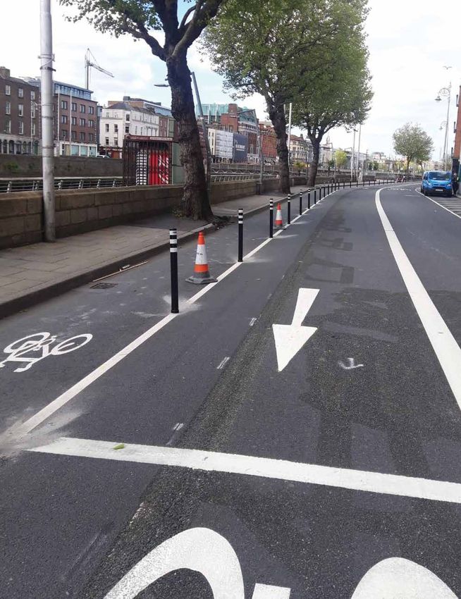
Enabling
the City to
Return to Work
Interim Mobility Intervention
Programme for Dublin City
May 2020
CONTENTS
1.    Introduction and Background     1

2.    Scope and Objectives            3

3.    Movement Capacity               4

4.    Methodology and Approach        9

5.    Proposed Mobility Measures      13
6.    Proposed Measures by Location   19
7.    Proposed Bus Network Measures   25
8.    Accessibility                   29
9.    Communications                  30
10.   Implementation and Next Steps   31
11.   Appendix                        33
Inte rim Mobility Interve nti o n Prog ra m m e fo r Du b li n C i t y

    1.         INTRODUCTION AND BACKGROUND
    The Covid-19 pandemic has affected all our lives and the way in which we work, socialise and
    communicate. It also has had enormous impacts on our transport system, radically reducing
    travel levels and likely to alter our patterns of movement for some time to come.

    During the period of maximum restrictions, when all but essential workers were required to stay
    at home, there were, not unexpectedly, dramatic declines in the numbers of people travelling each
    day. Car traffic fell to about 30% of pre-Covid levels, bus usage on city services dropped by 90%
    and rail usage reduced by about 97%.

    The overall aim of this document is enabling the city to return to work, to enable retail and leisure
    activities to restart and allow people to visit family and friends and, in time, schools and colleges
    to reopen all in line with government guidelines and timescales.

    As the restrictions are eased with workplaces, schools and shops re-opening, the numbers of
    people travelling and moving around the city will start to increase again. More space is required
    to be allocated to social distancing and to supporting shops and businesses operate in the new
    environment.

    In addition, during the period that a 2-metre spacing between passengers is required, there will
    continue to be a dramatic reduction in the capacity of the public transport system, down to about
    20% of its normal levels. As these, or some updated form of social distancing requirements are
    likely to remain in place for some time, the overall patterns of travel, in the short-term at least,
    will be significantly different from those that existed just a few months ago.

    In our most recent analysis, from November of last year, 116,287 people travelled into the city
    centre by public transport during the 7am to 10am peak period, representing just over half of
    the total numbers travelling to the city centre during this period. With a reduced public transport
    capacity, only about a fifth of this number will be able to use buses, trams and rail for these
    journeys in the coming months.

    What this means is that fewer people will be travelling on public transport and more people will
    need to be accommodated on other modes. Consequently, there will be many more people
    cycling each day, there will be an increase in the number of people walking and more people
    will wish to travel by car.

    To facilitate these new patterns of travel, some reallocation of road space will need to be
    introduced on many streets. These changes will also have to be considered in conjunction with
    social distancing requirements, which means that changes are needed to various footpaths and

   1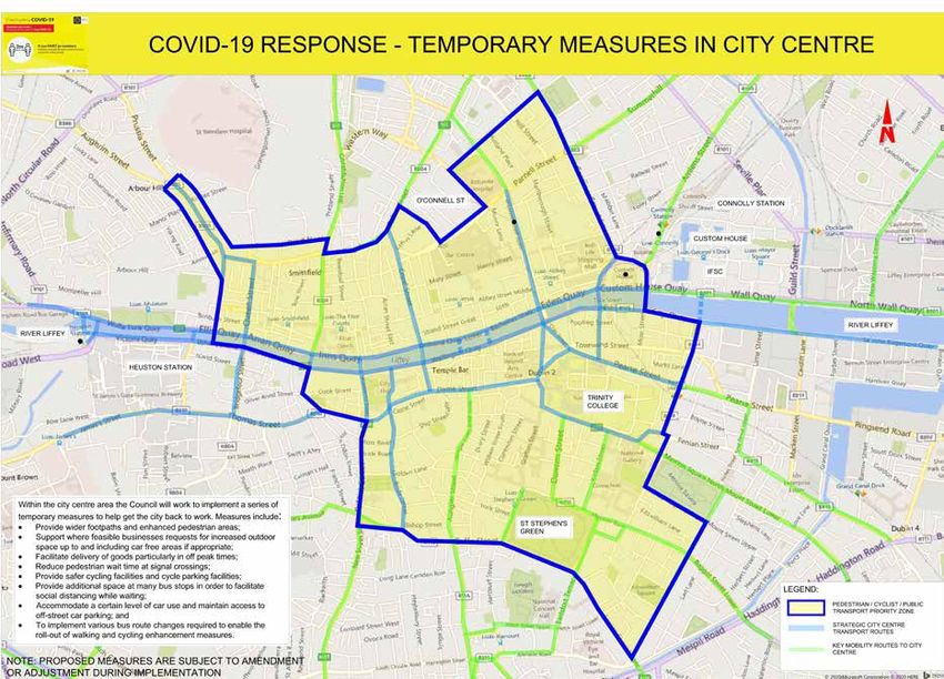
Inte r i m Mo bi l i t y Inte r ve nt i o n Progra mme fo r Dubli n Ci ty

public areas to meet these requirements and optimise the use of the space available. In addition,
there is a need to consider the needs of businesses, many of which may require additional external
space to operate successfully.

There is a need to implement these changes in an integrated, co-ordinated way. Accordingly,
this report sets out a framework of proposals developed by Dublin City Council and the National
Transport Authority (NTA) to address the new and urgent needs which have emerged as a result
of the Covid-19 Public Health Emergency in Ireland.

                                                                                                                          2
Inte rim Mobility Interve nti o n Prog ra m m e fo r Du b li n C i t y

    2.         SCOPE AND OBJECTIVES
    The programme initially looks at the links from the nearer urban villages to the city centre and
    within the city centre it looks at how a more pedestrian, cycling and public transport friendly centre
    can be set out. This is very much a “live” programme and over the next number of weeks, additional
    areas of the city and proposals will be added. The gradual reopening of the economy and society as
    set out by the Government strategy will present new challenges as it unfolds, so this must, of
    necessity, be a live programme, the implementation of which will be clearly evident on the ground
    across Dublin City over the coming months.

    The goal of this programme, in essence, is to allow the city to function under the new arrangements
    arising from the Covid-19 Public Health Emergency, both in terms of providing space for safe
    movement plus business activities, and in accommodating the changed transport patterns.
    At the heart of this plan are the following high-level aims:

         Ĥ        To ensure safe access to and movement within Dublin City for all users;

         Ĥ        To provide sufficient movement capacity to cater for the changed travel patterns; and

         Ĥ        To support the economic recovery of the city and the region.

    These high-level aims have been translated into transport-specific objectives as follows:

         Ĥ        To improve pedestrian safety through the provision of additional space for movement
                  and enhanced pedestrian areas;

         Ĥ        To enable more people to cycle by providing safer cycling facilities;

         Ĥ        To provide additional space at many bus stops in order to facilitate social distancing
                  while waiting;

         Ĥ        To accommodate a certain level of car use, calibrated with other transport needs,
                  including possible additional parking provision on the periphery of the city core area; and

         Ĥ        To implement various bus route changes required to enable the roll-out of cycling
                  and walking measures while still maintaining a strong public transport network.

    The measures developed in response to these objectives are being introduced to respond to a new
    and unprecedented emergency caused by the Covid-19 pandemic. They are being implemented on
    a temporary basis to respond to the urgent and immediate needs of the city. They will be reviewed
    periodically to assess their effectiveness and, because of their nature and type of implementation,
    can be modified as needed to respond to changing needs and requirements.

   3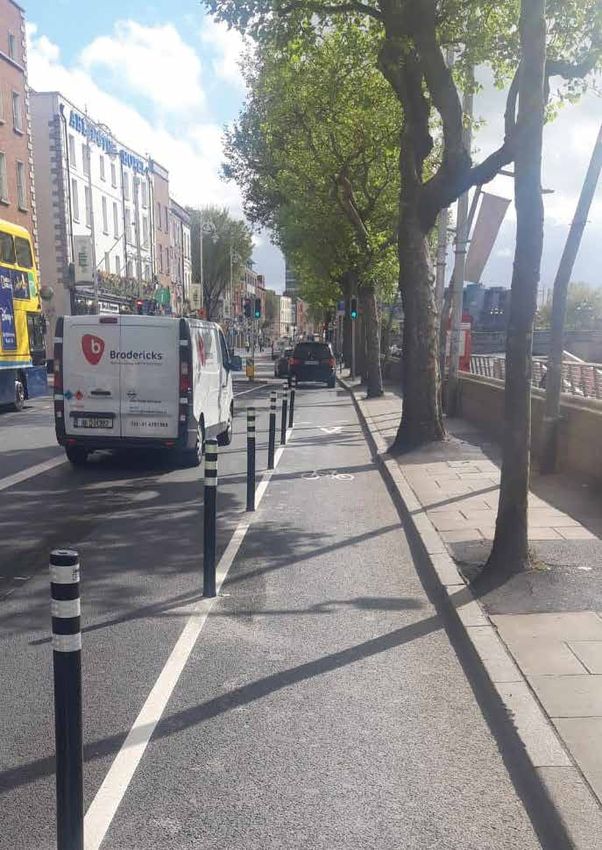
Inte r i m Mo bi l i t y Inte r ve nt i o n Progra mme fo r Dubli n Ci ty

3.          MOVEMENT CAPACITY
3.1.        Future Trends
As the economy re-opens on a post-Covid basis, travel patterns will change dramatically. Many
more people will use walking and cycling to access work, school and shop. While social distancing
requirements persist, there will be a greatly reduced passenger capacity available on public transport.
Many people will use their cars to travel to their places of employment and other destinations.

3.2.        2019 Canal Cordon Counts
The overall capacity of the city to accommodate movement into the city centre during peak periods
will be reduced and it will be important that the level of demand to access the city is calibrated, as
far as possible, against the available access capacity during peak periods. In addition, the receiving
environment both of the city centre and the urban villages has to be considered carefully so as to
ensure that unsafe conditions are not being created.

The table below sets out the number of persons crossing the canal cordon around the city centre
in the inbound direction for the period from 7.00am to 10.00am in November 2019. A total of
217,223 persons accessed the city through this cordon during this period, with just over half (53.5%)
travelling by public transport.

     MEANS OF TRAVEL 2019
     Bus                                                                                          65.048

     Rail                                                                                         37,407

     LUAS                                                                                         13,832

     ALL PUBLIC TRANSPORT                                                                         116,287
     Car                                                                                          57,985

     Taxi                                                                                         2,661

     Walk                                                                                         24,691

     Cycle                                                                                        13,131

     Goods                                                                                        983

     Motorcycles                                                                                  1,485

     TOTAL PERSON TRIPS                                                                           217,223

                                                                                                                           4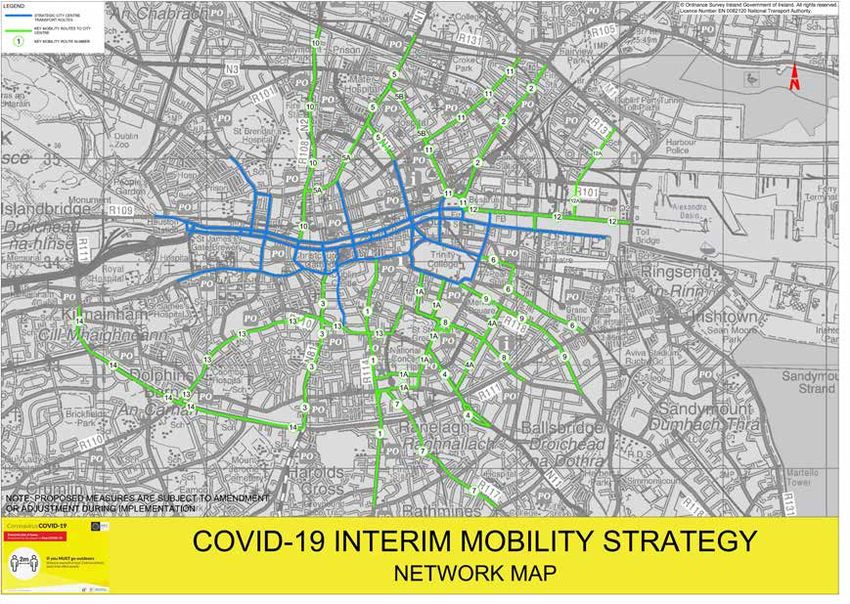
Inte rim Mobility Interve nti o n Prog ra m m e fo r Du b li n C i t y

    3.3.       Change in Public Transport and Car Capacity
    During the period of the 2-metre social distancing requirement on public transport, capacity will
    reduce to around 20% of pre-Covid-19 levels. While the theoretical capacity of public transport
    over the three-hour morning peak period will be around 37,000 passengers, the practical
    capacity (assuming 2-metre spacing) will be less, as not every bus, tram and DART can be perfectly
    filled over this period. Applying a factor of 0.8 to account for unevenness of passenger loadings
    indicates a likely public transport capacity of about 30,000 people. Clearly, if the 2-metre social
    distancing requirement was altered in the future, the capacity levels would similarly alter.

    Additionally, the capacity of the overall vehicular system is also reduced, albeit by a much smaller
    amount. Traffic signal timings across the city have been adjusted to reduce pedestrian waiting times
    and also, particularly in the city centre, pushbuttons are automated between 07:00-19:00. These
    combined changes will assist in reducing any build-up of pedestrians waiting to cross and will need
    to be kept in place for the foreseeable future.

    These changes, together with the need to utilise some road space to create wider footpaths for
    social distancing measures plus the implementation of temporary cycling facilities, will result in an
    overall reduction in car capacity to access the city centre during peak periods. While it is difficult
    to exactly quantify, it is estimated that there will be approximately a 30% reduction in vehicular
    capacity at junctions throughout the city.

                                                 2019 Figures            Potential Future Figures
         All Public Transport                    113,382                 30,000

         Car                                     57,985                  41,000

         TOTALS                                  171,367                 71,000

    3.4        Overall Change in Transport Capacity
    While there is expected to be a significant reduction in public transport capacity and a smaller
    decrease in car capacity, there is also clear evidence emerging that the numbers of people walking
    and cycling will increase in the coming months. It is part of this programme to encourage, where
    possible, people to walk and cycle, both as a way of safely travelling but also to reduce demand
    on public transport and vehicular traffic and leave these modes to people who cannot use an
    alternative for whatever reason.

   5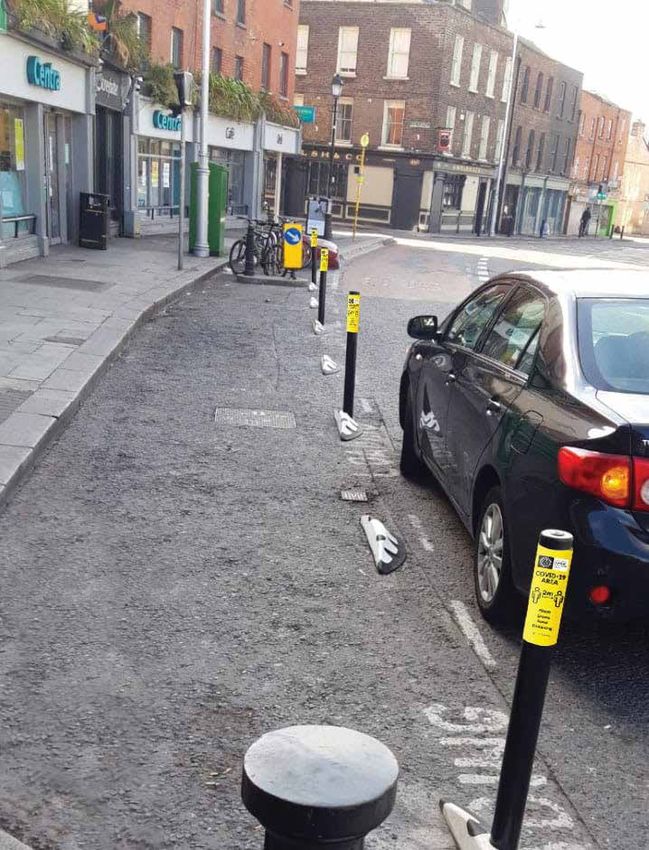
Inte r i m Mo bi l i t y Inte r ve nt i o n Progra mme fo r Dubli n Ci ty

While predicting future numbers is challenging, it does appear, having regard to trends and activities
elsewhere, that a tripling of cycling numbers across the canal cordon is a reasonable target, coupled
with a doubling of the numbers walking to employment and other activities. This would provide the
following capacity /usage comparison between the situation prior to Covid-19 and the position in
the coming months.

                                                 Likely                                        Potential
                          2019                   Future                                        Future
                          Figures                Change                                        Figures
 All Public Transport     116,287                80% Capacity Reduction                        30,000

 Car                      57,985                 Approx. 30% reduction                         41,000

 Taxi                     2,661                  Assume 30% reduction                          1,900

 Walk                     24,691                 Target 100% increase                          50,000

 Cycle                    13,131                 Target 200% increase                          39,000

 Goods                    983                    No change                                     1,000

 Motorcycles              1,485                  No change                                     1,485

 TOTALS                   217,223                                                              164,385

If the above very substantial increases in walking and cycling are to be achieved, there must be
a commensurate increase in facilities to accommodate these figures and this is why so much
emphasis is placed on safety for pedestrians and cyclists. However, even if these substantial changes
are achieved we still will have a deficit of over 50,000 people trips across the morning peak.

To allow the various transport modes to operate effectively in the months ahead, arrangements to
reduce the number of people travelling during the peak period by this amount, roughly 25% of the
total 2019 peak period travel, will need to be put in place. This means encouragement of measures
such as more people working from home, travelling to shops at non-peak hours for some people,
and staggering work start times to move some journeys to outside of peak hours. This is a matter
which we would urge individual companies and organisations to consider in their planning for
dealing with the relaxation of restrictions.

                                                                                                                          6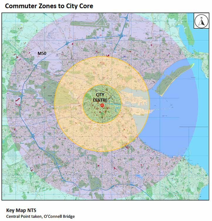
Inte rim Mobility Interve nti o n Prog ra m m e fo r Du b li n C i t y
3.5. Increased Cycling and Walking
Fundamental to the above outcome, is the need to very significantly increase the numbers of people
walking and cycling into, and around, the city. Part of the purpose of this programme is to support
that increase through temporary interventions on various streets to enhance pedestrian
arrangements and provide better cycling facilities.
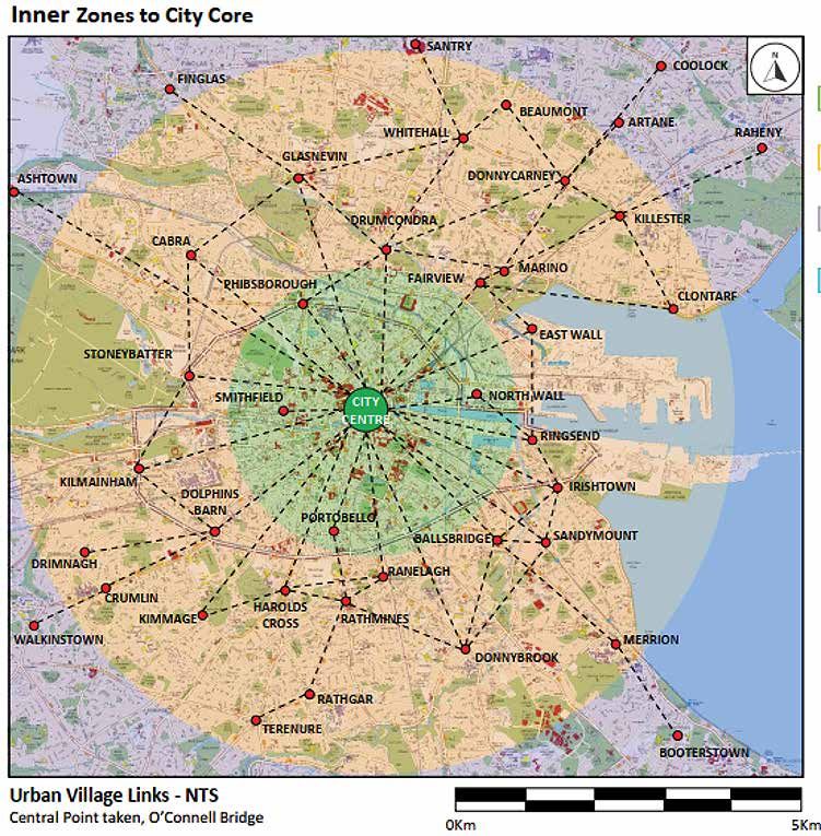
The following figure shows the various key locations within the 2km and 5km band and the linkages
that exist to, and between, those centres. While cycling and walking will not be feasible for some
people, it is clear that it will become a viable alternative for many more people in the period ahead.
By choosing to walk or cycle users will not only accommodate their own mobility but will leave the
public transport system for those who don’t have the same alternatives and we would therefore ask
people to carefully consider if this represents a viable option for them.
7Inte r i m Mo bi l i t y Inte r ve nt i o n Progra mme fo r Dubli n Ci ty
8Inte rim Mobility Interve nti o n Prog ra m m e fo r Du b li n C i t y
4. METHODOLOGY AND APPROACH
4.1. Scope of Programme
This section outlines the approach adopted by the Council and the NTA in developing proposals
to address the changed travel patterns that are likely to apply in the coming months.
Given the urgency of developing a framework to guide the introduction of the necessary
measures, this initial version of the Covid-19 - Dublin City Interim Mobility Intervention Programme
is focussed on the city centre, the radial routes approaching the central area and a number of urban
village interventions. It is acknowledged that additional measures and interventions are required in
other areas of the city. Accordingly, it is intended that this initial version of the overall programme
will be updated on an on-going basis with proposals in respect of those other areas.
In particular work is underway on assessing the numerous requests for interventions that have
been received from the public and elected representatives. It is therefore intended to expand this
document in the future to include measures to assist in the urban villages and to have a school
focussed program to assist in return to school mobility.
4.2. Approach
In preparing this programme, the overall approach has considered all modes but with a particular
emphasis on active modes given the anticipated increases in those forms of movement.
The on-going requirement for social distancing, together with the likely needs of some
businesses for additional external space, has also been considered.
The process undertaken has sought to identify routes and locations where the implementation
of specific measures can provide the most benefits. Mapping and desktop surveys have been
undertaken, supported by on-street visual analysis, to identify potential arrangements for
implementation in those areas. However, given the limited information available at this stage,
the planned measures may have to be modified and amended to reflect more detailed site-specific
information. A key part of the overall process of implementation is adopting a flexible approach to
issues as they arise, and to this end we will have a dedicated information channel to allow for quick
communications and resolution.
9Inte r i m Mo bi l i t y Inte r ve nt i o n Progra mme fo r Dubli n Ci ty
4.3. Identification of Locations for Measures
As the initial scope for this programme is focussed on access to and movement within the city
centre, it has been decided to prioritise the radial links with the highest levels of cycling and walking
movement, together with the core city centre streets. The emphasis is on rapid and temporary types
of intervention using preformed materials i.e. bollards, orcas, etc.
However, it is also acknowledged that, as these measures will be in place for a considerable period
of time, other types of intervention such as the use of preformed materials for build outs and the
10Inte rim Mobility Interve nti o n Prog ra m m e fo r Du b li n C i t y
use of temporary road materials to build up some sections of road to footpath level will have to be
considered. The use of planters and other innovative designs will also feature as this programme
expands, particularly into the urban villages and other areas.
In order to identify the particular routes, the Canal Cordon Count was analysed to determine where
greatest demand for walking and cycling was recorded. The figure below graphs the number of peo-
ple crossing the canal cordon (both directions) during the morning peak period from 7am to 10am in
November 2019.
Pedestrians and Cyclists
Inbound and Outbound 7am - 10am
Richmond Street South
North Strand Road at Newcomen Bridge
Northwall Quay at the bridge
Leeson Street Lower
Ringsend Road
Grand Canal Street Upper
Lower Dorset Street
Baggot street Lower (Mccartney Bridge)
Charlemont Street
Clanbrassil Street Upper
Northumberland Road
Phibsborough Road
Summerhill Parade at the bridge
Dolphin’s Barm
Hubard Bridge
Sherrif Street Upper at the bridge
Chesterfield Avenue
Donore Avenue
Russell Street at the bridge
Conyngham Road
Old Cabra Road
Herberton Road
South Circular Road
Annamore Road
North Road
Blackhorse Avenue
St Johns Road West
Kilmainham Lane
Charleville Road
Ossary Road
Old Kilmainham Road
Royal Canal Bank
0 1,000 2,000 3,000 4,000 5,000 6,000
Pedestrians Cyclists
11Inte r i m Mo bi l i t y Inte r ve nt i o n Progra mme fo r Dubli n Ci ty
Within the city centre, various locations will be identified which could be considered for
pedestrianisation in order to both facilitate social distancing and to provide the potential for use
of some of the external space by adjacent businesses.
Both the Council and the NTA are acutely aware of the needs of the city’s retailers, cafés, restaurants
and bars. As such, a balance will need to be struck between the need for space for pedestrians,
queueing outside shops and space that may be desirable for outdoor tables and seating. A range
of measures may be explored, including allowing additional outdoor space at particular times.
4.4. Extent of Measures
While a key part of this programme is focussed on active travel modes, continuing to facilitate the
efficient movement of public transport as well as managing car movement throughout the city
remain important objectives. In developing the planned portfolio of interventions, care has been
taken to carefully balance the needs of each of these modes in deriving the various proposals.
In relation to bus transport, despite the lower numbers of passengers per vehicle, the same number
of buses will be operating on the city streets as operated prior to the current pandemic. Accordingly,
it will be important to maintain the current levels of bus priority on the various streets in order to
enable the service to operate as efficiently as possible.
There is the potential for increased car use in the months ahead as people, at present, may feel safer
in their own vehicle rather than sharing a public transport journey with others. This reality has been
carefully considered in the preparation of this programme. As a result, measures which facilitate
continued car use have been identified and incorporated into this framework. However, this has to
be calibrated against the other needs for road space and junction capacity which exist.
Other supporting measures have also been included in the programme such as reducing vehicular
speeds, changing traffic signal timings at junctions, arrangements for delivery and additional
potential off-street parking provision. In addition, the need for focussed communications around
the changed city environment and the altered transport arrangements has been recognised.
Details of the proposed temporary measures are set out in the following chapter with further
details provided in the attached appendix.
12Inte rim Mobility Interve nti o n Prog ra m m e fo r Du b li n C i t y
5. PROPOSED MOBILITY MEASURES
This section details the different types of temporary mobility measures that are proposed
to facilitate increased numbers of pedestrians and cyclists, and the efficient movement of
public transport, while managing access for deliveries and private car use during the period of the
Covid-19 emergency.
5.1. Pedestrian Areas
In order to create more space for pedestrians required to facilitate social distancing, it is
proposed to expand pedestrian areas where possible, and to do so in a safe and clear manner.
The priority locations for such measures will be in the city core and in the urban villages, where
there is both a high pedestrian footfall and where footpath widths are constrained. Such temporary
measures would require a review of the use of the existing road space adjacent to the footpath.
For example, depending on the location, where there is queueing outside shops and cafés,
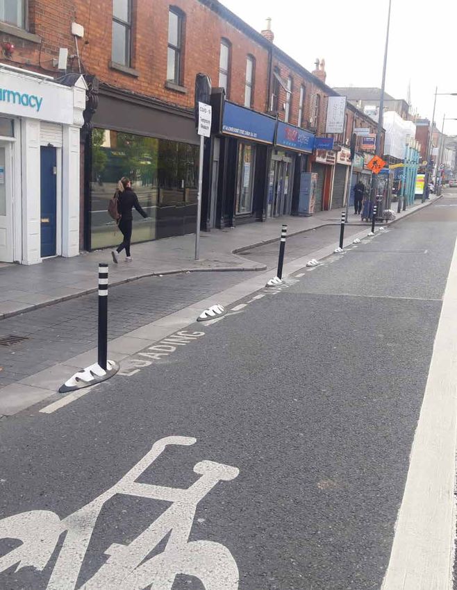
pedestrian areas may be expanded into loading bays by using protective bollards.
The Council is open to the idea, and willing to explore the potential of, increasing the number
and extent of pedestrian areas in the city core. Options that may be considered include restricting
deliveries to certain times at different locations. This may facilitate the pedestrianisation of some
city streets, and free up some additional space for businesses to operate while complying with
Covid-19 restriction requirements.
The Council will work with relevant stakeholder to develop a potential list of locations and
options with the focus on facilitating businesses returning to commercial activity.
5.2. Pedestrian Signal Crossings and Waiting Times
In order to reduce the time that people are waiting for pedestrian crossings to turn green, the
maximum amount of time allocated to a complete traffic cycle, (allowing all movements in the
junction operate, if demanded) has been reduced from 120 seconds to 80 seconds throughout the
city. As the amount of time for the pedestrian green and amber man is based on the time taken to
safely cross the road, and therefore remains the same, the additional time has been taken from
that allocated to vehicles.
This has resulted in shorter green times at all junctions and an expected reduction in traffic capacity
of up to 30%. As traffic volumes increase, following advancement through the different phases of
13Inte r i m Mo bi l i t y Inte r ve nt i o n Progra mme fo r Dubli n Ci ty
the government roadmap for easing of restrictions, and while the requirement for social distancing
remains in place, the cycle length will remain capped at 80 seconds. This will result in major
reduction in capacity for motorised vehicles going forward. The impact of this on public
transport journey times and reliability will also require careful monitoring.
In addition to reducing the wait times for all junctions, a number of pedestrian crossings in the
city centre and key locations in urban villages have been set to automatically operate from
7am-7pm to reduce vehicular speed, to aid pedestrian movement and to minimise contact
with signal push buttons.
It is of vital importance that the city centre is not used by through traffic which has no requirements
to be in the city centre and which can use alternative routes. The orbital routing system, which was
recently updated on street, will assist with this.
14Inte rim Mobility Interve nti o n Prog ra m m e fo r Du b li n C i t y
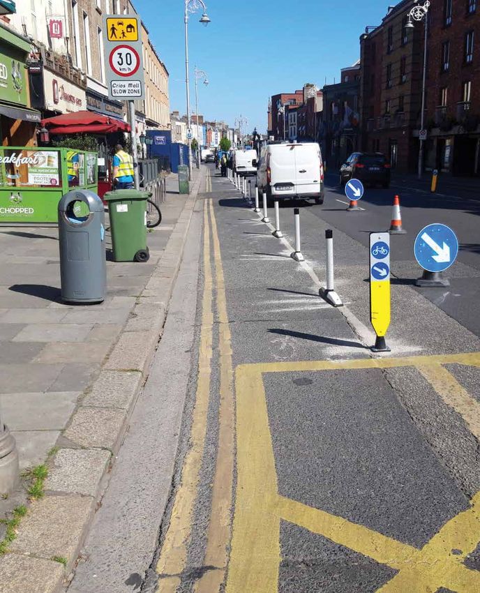
5.3. Protected Cycle Facilities, Contra-Flow Facilities & Cycle Parking
To facilitate a much higher number of cyclists, it is proposed to provide safer cycling infrastructure
through the implementation of protected cycle lanes. This may involve reusing existing road space
by removing on-street parking and protecting that road space for cycling via protection bollards and
other cyclist protection measures. An example of this is the recently reallocation of the North Quays
on-street parking for a wider pedestrian area and a cycle lane.
Other locations may involve reducing the number of traffic lanes to accommodate protected
cycling facilities on both sides of the road, while maintaining a balance for other required
services in that area.
It is also intended to provide safe contra-flow cycle facilities on streets where demand for
such movement has been identified. An example of this has already been implemented
on Nassau Street.
Despite the suspension of the installation works due to lockdown, cycle parking design works have
continued over the last few months. With the resumption of installation works and the easing of
restrictions, we are targeting the installation of at least 1000 new stands this year. In addition, we
will seek to install new cycle parking in key locations to compliment the overall Covid-19 mobility
strategy.
5.4. Continuous Bus Lanes and Bus Priority Measures
As traffic volumes are expected to increase over the coming weeks and months, it is important,
insofar as is practicable, to maintain the reliable and consistent bus journey times that have been
experienced during the period of restrictions. Such measures would include the provision of
contra-flow bus lanes, extending existing bus lanes to the stop line, providing early starts for buses
at traffic signals and providing traffic signal priority for buses. In some locations, the provision of an
additional bus lane to allow passing buses to overtake stopping buses without undue delay may be
required.
Providing contra-flow bus lanes on selected approaches to the Quays will provide improved
connectivity for cross-city bus services, while facilitating pedestrian and cycle measures in the core.
One such proposal is to provide a southbound contra-flow bus lane on Winetavern Street, thus
reducing the requirement for buses to travel into College Green and so reduce pressure
on the pedestrian space in this area.
15Inte r i m Mo bi l i t y Inte r ve nt i o n Progra mme fo r Dubli n Ci ty
16Inte rim Mobility Interve nti o n Prog ra m m e fo r Du b li n C i t y
5.5. Car Parking Spaces & Loading Bays
In some locations, on-street car parking and loading bays may have to be removed or relocated to
allow for greater provision for pedestrians. Where possible alternative delivery locations will be
provided. The option of identifying specific delivery times off-peak for goods deliveries is also to be
considered.
5.6. Off-Street Car Parks
As people return to work, alternative locations for car parking may need to be identified. For
example, allowances for driving partially into the periphery of the city, parking and completing the
remainder of the journey by foot or by bicycle. While existing city centre car parks will
remain accessible, alternatives to driving into the core of the city will be encouraged.
5.7. Reduce Speed Limits
In line with other European cities consideration is been given to temporarily reducing vehicular
speed limits on many of the routes to 30km per hour, in order to protect the larger numbers of
pedestrians, cyclists and vulnerable road users moving around in these areas and on the road
carriageway due to Covid-19 travel restrictions and social distancing requirements. This measure
will require the consent of the elected Councillors and a proposal in this regard will be brought to
them shortly.
5.8. Queueing Space at Bus Stops
Consideration will be given to the location of bus stops on footpaths to ensure there is sufficient
space for people to pass bus passengers waiting at the stops and, similarly, in relation to people in
outdoor seating for restaurants/cafés/bars.
Temporary buildout platforms of various types have been pioneered in other cities and, in the
next number of weeks; a pilot installation will be put in place at a trial location in the city. If this is
successful, this technique will be considered in locations where there are high numbers of people
queueing and the footpath is very narrow. In some cases bus stops may be temporarily suspended
or moved if social distancing cannot be maintained.
Further information on bus stops can be found in Chapter 7.
17Inte r i m Mo bi l i t y Inte r ve nt i o n Progra mme fo r Dubli n Ci ty
5.9. Outdoor Areas
In order to help businesses function within the Covid-19 restrictions, businesses may require space
outside their premises either for waiting areas or some form of outdoor use. The Council is open to
considering these requests where the existing space is adequate or where additional space can be
provided, subject to the suitability of the location. Of necessity, these will be considered on a street
by street basis as requests are made.
18
14Inte rim Mobility Interve nti o n Prog ra m m e fo r Du b li n C i t y
6. PROPOSED MEASURES BY LOCATION
The specific interventions proposed are indicated at a concept level on the maps in the
Appendix, which cover each of the routes included in this initial version of the framework
plus the city centre area.
Because of the urgent need to quickly introduce these measures to accommodate the revised travel
patterns, the interventions have been identified and developed on an accelerated basis, largely
based on desktop work, camera surveys and limited on-street visual analysis. Accordingly, the planned
measures may have to be modified in advance of, or during, implementation to address site-specific
issues and additional constraints that may be identified.
6.1. Routes
The 14 route maps detailing the interventions are included in the Appendix in the following
sequence:
1. Rathmines – Richmond Street South – George’s Street – Dame Street
The Rathmines to Dame Street routes is the busiest artery on the southside of the city in terms
of pedestrians and cyclists. In addition it has a large number of retail outlets, cafés and
restaurants along its route.
2. Fairview – North Strand – Newcomen Bridge – Amiens Street – Beresford Place
This route collects all of the demand from the north-eastern suburbs of Dublin via the
Clontarf Road, Howth Road and Malahide Road. It also contains Connolly Station and Busáras.
The presence of two major national transport facilities here reinforces the requirement for an
improved pedestrian environment.
3. Harold’s Cross – Clanbrassil Street – Dame Street
Harold’s Cross collects travel demand from a number of suburbs from the south and south west,
as Kimmage Road Lower and Harold’s Cross Road converge close to the canal. Clanbrassil Street
is a wide dual-carriageway further in with potential for road space reallocation.
19Inte r i m Mo bi l i t y Inte r ve nt i o n Progra mme fo r Dubli n Ci ty
4. Donnybrook – Leeson Street – College Green
This is a major arterial link for the city, taking in demand from Bray through multiple suburbs
and connecting with the major trip attractor of UCD along the route. It feeds directly into the
office core of the southeast city centre and the retail core at Grafton Street.
5. Drumcondra – Dorset Street – O’Connell Street
The Drumcondra route is an extremely busy link , taking in demand from major suburbs such as
Swords and Santry. Drumcondra and Dorset Street comprise very important local centres with
extensive economic activity along the routes.
6. Grand Canal Street – Pearse Street
This route is a vital link from the southside suburbs into Grand Canal Docks and onwards into
the north Docklands. Both Grand Canal Dock and Pearse rail stations feed out onto this
crossing point, requiring measures to cater for increased pedestrian and cycle movement.
7. Ranelagh – Charlemont Street
Ranelagh village is a major centre of activity and a significant generator of walking and cycling
trips over the canal towards Charlemont street and onward towards Camden Street to the west,
and the southeast office core to the east.
8. Baggot Street Lower – Merrion Row
This route is at the heart of the south city business district and contains a significant number of
local retail outlets, cafés and restaurants catering for workers and residents in the area. It also
connects the southeast retail core at St. Stephen’s Green directly to Ballsbridge.
9. Ballsbridge – Mount Street – College Green
Ballsbridge comprises an extension of the southeast business district and its connection to the
city centre will be vital during this period. There is considerable office and local retail activity
along this route and it contains the National Maternity Hospital and Merrion Square Park.
20Inte rim Mobility Interve nti o n Prog ra m m e fo r Du b li n C i t y
10. Phibsborough – Church Street – North Quays
The Phibsborough route is an important one for bus movements from the northside of the
city. It also carries a high number of cyclists and pedestrians into the city. It is highly
constrained in terms of width in certain locations closer to the city centre.
11. Ballybough – Summerhill Parade
This link connects directly to O’Connell Street via Parnell Street, providing an alternative
route for all modes to the much busier Amiens Street link, and as such carries a significant
number of pedestrians and cyclists. This is a generally wide roadway, incorporating
dual-carriageways in parts.
12. Docklands – North Wall Quay
Docklands is one of the most important generators and attractors of trips in the city and as
the economy reactivates, it will be important to ensure that travel demand to and from this
area can be accommodated.
13. Crumlin – Cork Street – Kevin Street – St. Stephen’s Green
Much of the demand from the southwest suburbs of Dublin converges onto the Crumlin
Road radial route. As it approaches the city, it picks up further significant demand from the
inner city residential areas of Dublin 8.
14. Grand Canal
The Grand Canal greenway runs from the Docklands as far as Portobello. From there
westwards, there is no segregated provision for cyclists, despite the link catering for a
significant number of cycle trips along its entire length.
6.2. City Centre
The preceding sections set out the measures proposed on the radial routes approaching the city.
It is important that the full benefits of these measures are realised as the routes converge on the
city centre. The guiding principles of this programme for the city centre are as follows:
Ĥ Provide wide footpaths and enhance pedestrian areas;
21Inte r i m Mo bi l i t y Inte r ve nt i o n Progra mme fo r Dubli n Ci ty
Ĥ Support, where feasible, business requests for increased outdoor space up to
and including car free areas either all the time or at designated hours if appropriate;
Ĥ Facilitate delivery of goods particularly in off-peak times;
Ĥ Reduced pedestrian waiting times at signalised crossings;
Ĥ Provide safe cycling facilities and cycle parking facilities;
Ĥ Provide additional space at bus stops to facilitate social distancing while queueing;
Ĥ Accommodate a certain level of car use and maintain access to off-street car parking; and
Ĥ Implement various bus route changes required to enable the roll out of walking
and cycling enhancement measures.
2223
Coronavirus COVID-19
Everyone stay at home.
Everyone has the power to Stop COVID-19
If you MUST go outdoors
COVID-19 RESPONSE
Distance yourself at least 2 meters (6 feet)
away fom other people
- TEMPORARY MEASURES IN CITY CENTRE
Inte rim Mobility Interve nti o n Prog ra m m e fo r Du b li n C i t yInte r i m Mo bi l i t y Inte r ve nt i o n Progra mme fo r Dubli n Ci ty
6.3. Overall Map of Proposals.
The following map shows the network combination of the overall proposals for Phase 1.
Further areas and interventions will be added in later versions.
COVID -19 INTERIM MOBILITY STRATEGY
NETWORK MAP Distance yourself at least 2 meters (6 feet)
If you MUST go outdoors
away fom other people
Coronavirus COVID-19
Everyone has the power to Stop COVID-19
Everyone stay at home.
24Inte rim Mobility Interve nti o n Prog ra m m e fo r Du b li n C i t y
7. PROPOSED BUS NETWORK MEASURES
7.1. Introduction
In line with the requirement to free up space on our urban realm to provide for social distancing
requirements, there is a need to review the current use of space, including that used by buses in the
city centre.
Increased space for walking and cycling, as well as changes to traffic signalling and other required
traffic management interventions, will have knock-on effects on how buses can access and serve the
city centre. Opportunities will also be created which may offer better routing options for some bus
routes serving the city and providing additional bus priority.
7.2. Reasons for Change
‘Spreading the load’ of bus services across the city streets
Dublin City centre’s streetscape is restricted and congested, meaning that space is at a premium.
Now with social distancing restrictions, more space is required for pedestrians and cyclists, and
taking space currently used for roads, in most cases, is the only option available.
There will need to be a changing of some bus routes onto routes which are capable of both
providing safe queueing space and ensuring that there is a good level of bus priority. Therefore,
what is being looked at is to spread the loading around the city and in particular move routes from
the Camden Street Georges Street routes on to the Stephens Green Dawson Street alignments
as well as provide a contra-flow bus lane on Winetavern Street. This will allow the Georges Street
alignment to have much better pedestrian and cycling facilities and in turn the reduction of bus
services in the Dame Street area will allow for footpath widening which is a key priority.
In the College Green area, existing space for pedestrians will be increased and the protected cycle
route will be extended. As services are diverted in a phased manner, then this will allow for
gradually increased space for pedestrians and eventually the conversion of the complete space to
allow for better pedestrian and cycling provision along the College Green and Dame Street route.
Social Distancing at Bus Stops
Everyone likes to be able to get on their bus at their favourite stop. However, the space
available at some of our city centre bus stops will not facilitate an appropriate level of social
distancing unless significant modifications are made.
25Inte r i m Mo bi l i t y Inte r ve nt i o n Progra mme fo r Dubli n Ci ty
Accordingly, it is likely that the use of bus stops will need to be distributed over a wider area to
allow more room for social distancing, both while people are waiting for buses and while dispersing
after disembarking. This is likely to mean that the number of buses stopping at specific stops may
need to be reduced while some other bus stops may need to be removed completely. It is likely that
passengers will be required, in some instances, to walk further to bus stops to ensure a safer spread
of bus loading /unloading.
Varying bus routes along different streets to spread the load of passengers to a number different bus
stops, as well as using bus stops with more kerb space for waiting passengers to social distance, will
be a critical element in addressing this issue.
7.3. Proposed Interventions
It is proposed to divert a number of bus routes traversing the south side of the city centre. This
area has a high density of bus routes, and corresponding busy bus stops. Coupled with the various
interventions planned on these routes to enable safe pedestrian movement and cycling facilities, the
existing bus service pattern would make it impossible to facilitate or manage social distancing at an
appropriate level on many of these streets.
On the south side of the city centre, the current pattern of bus movement is very heavily reliant on
the spine route of College Street and Dame Street with several bus services using this route. This
area also represents the highest concentration of pedestrian footfall in the city, with a high number
of people traversing College Green on an average day.
Catering for these levels of both bus and pedestrian movement in these areas is no longer feasible
given social distancing requirements. As such, it is proposed to amend the routes of bus services
using this link, and adjacent areas, to ensure that space can be provided for pedestrians in particular,
and that bus stop locations can be more carefully managed. It is proposed that the bus routings will
be altered to avail of existing and improved access routes, predominately centred on bridges
crossing the Liffey River.
26Inte rim Mobility Interve nti o n Prog ra m m e fo r Du b li n C i t y
It is proposed to develop three predominant bus access radial routes – aligned around the
O’Connell Bridge–Grafton Street Lower – axis as follows:
(i) West;
(ii) Central; and
(iii) East.
West Access Radial Route
This route will allow buses coming from the Cork Street and High Street directions to use the river
crossing at O’Donovan Rossa Bridge via Winetavern Street.
These bus routes, along the western alignment will be facilitated by a new contra-flow bus lane on
Winetavern Street as well as measures on other streets.
Central Access Radial Route
This route will cater for the majority of bus routes currently running along the O’Connell Street
alignment to the south of the city, as well as some services coming from the Quays to the south side
of the city centre. It will run via D’Olier Steet–Westmoreland Street to Grafton Street Lower and
Dawson Street-Kildare Street. Limited services will also operate via Hawkins Street.
This route will serve buses travelling to/ from the south and south east side of the city, with new
route options on St. Stephens Green South and Earlsfort Terrace.
Eastern Access Radial Route
This route will cater for the majority of bus routes currently running along the Quays and onto the
south of the city. This route will use the river crossings at O’Connell Bridge, Rosie Hackett Bridge
and Memorial Bridge, with routes then running on Townsend Street and Pearse Street, and in most
cases routeing along Westland Row to travel south / north.
This link will serve buses from the north and west of the city, accessing the south east city centre
quadrant. Improved bus priority, including the potential for a northbound bus gate on Westland Row
will aid the operation of the increased services on this alignment.
27Inte r i m Mo bi l i t y Inte r ve nt i o n Progra mme fo r Dubli n Ci ty
16
28Inte rim Mobility Interve nti o n Prog ra m m e fo r Du b li n C i t y
8. ACCESSIBILITY
In developing this overall strategy to address mobility-related issues that have emerged as a result of
the Covid-19 pandemic, both the Council and the NTA have been conscious of the particular needs
of people with disabilities.
Some of the measures being developed will be directly assistive to people with disabilities.
For example, traffic signals in the city centre have been adjusted to provide automatic activation of a
pedestrian crossing signal during daytime hours. This has the additional benefit of reducing waiting
times and reducing crowding at crossing points.
While there are a range of measures proposed under the programme, it is intended that the
proposals will not diminish or reduce any of the accessibility arrangements already in place. Many of
the measures will, directly or indirectly, assist in movement by various categories of disabled users.
For instance, the allocation of some road space to accommodate pedestrians, through temporary
bollards, should ensure that a person in a wheelchair, or a visually impaired person, will continue to
able to use the footpath while able-bodied users can use the road carriageway, thereby ensuring
appropriate social distancing.
At all stages the focus will be to ensure that the temporary measures are safe and do not impact on
any existing provisions for mobility or visual impaired users. While initial interventions will largely
be through temporary materials such as plastic bollards and barriers, it may be possible that more
physical widening of footpaths can be achieved in later phases, which would allow more accessibility
elements to be considered.
Because interventions are being developed and implemented in response to a national
emergency, and are time critical, the normal levels of consultation and dialogue are not
feasible. However, as part of the implementation stage, it is intended that a dialogue process
will be established to facilitate more focussed input in relation to accessibility issues into
individual proposals.
Measures implemented will be subject to on-going review and where feasible, modifications
can be accommodated where necessary.
29Inte r i m Mo bi l i t y Inte r ve nt i o n Progra mme fo r Dubli n Ci ty
9. COMMUNICATIONS
Communication is an imperative in generating public awareness of, and fostering public support
for this programme. The communication strategy will ensure all information in relation to the
programme is up-to-date, accessible and coherent. It will focus on the following key messages:
Ĥ Why this getting back to work mobility intervention programme is required and what it
aims to achieve;
Ĥ The measures to be implemented at each phase;
Ĥ Progress on implementation;
Ĥ The promotion of active travel modes; and
Ĥ Advice and support on travel plans for businesses.
Multiple communication methods and channels will be established and used to disseminate
information and ensure optimum reach with all stakeholders. Images, maps and videos will be
developed and published where possible. Channels will include regular Councillor briefings,
a dedicated public webpage, social media platforms and dissemination of flyers. A dedicated
email address will also be established to allow for regular feedback on the measures.
30Inte rim Mobility Interve nti o n Prog ra m m e fo r Du b li n C i t y
10. IMPLEMENTATION AND NEXT STEPS
There will be a phased approach to implementation over a six to twelve month period.
Measures will be implemented on a temporary basis and will be subject to review.
Other locations will be added to the framework as areas are surveyed, equipment becomes available
and local intervention proposals are developed.
Local intervention works across the city commenced in late April and these form part of the
mosaic of measures to be implemented as part of the Council’s Covid-19 response.
Some of examples of local works implemented to-date include:
Ĥ Increased footpath capacity:
Ĥ Closure of loading bays at Dorset Street, Capel Street, Rathmines, Stoneybatter
and Fairview; and
Ĥ Cycle Safety interventions:
[ Installation of Nassau Street contra-flow cycle track from Clare Street
to Dawson Street; and
[ Partial installation of Quays Section of Interim Liffey Cycle route.
On-street car parking has been removed from Inns Quay and Ormond Quay and
section of work from Church Street to Halfpenny Bridge will be substantially
completed by mid-May. Works to then commence on other sections of the route.
A program of further specific works and interventions is being developed for implementation based
on the methodology outlined in Chapter 4. These works are being prioritised in areas of high footfall
and cycling numbers to ensure that the maximum number of people can move freely throughout the
city on safe, connected and coherent transport routes.
The works program will determine locations for priority intervention, with many of the key locations
for intervention identified and development of site specific interventions underway.
31Inte r i m Mo bi l i t y Inte r ve nt i o n Progra mme fo r Dubli n Ci ty
The proposed interventions will be rolled out in a phased sequence to allow the city to open
up gradually whilst remain operational and accessible.
Following the installation of any intervention, a monitoring and review of works will be
undertaken as there may be a need to adjust these interventions as restrictions are lifted and
travel patterns begin to evolve.
32
1411. Appendix
CITY CENTRE AND ROUTE DRAWINGS
Rathmines – Richmond Street South – George’s Street
Route 1 & 1A 34
– Dame Street
Fairview – North Strand – Newcomen Bridge – Amiens Street
Route 2 35
– Beresford Place
Route 3 Harold’s Cross – Clanbrassil Street – Dame Street 36
Route 4 & 4A Donnybrook – Leeson Street – College Green 37
Route 5, 5A & 5B Drumcondra – Dorset Street – O’Connell Street 38
Route 6 Grand Canal Street – Pearse Street 39
Route 7 Ranelagh – Charlemont Street 40
Route 8 Baggot Street Lower – Merrion Row 41
Route 9 Ballsbridge – Mount Street – College Green 42
Route 10 Phibsborough – Church Street – North Quays 43
Route 11 Ballybough – Summerhill Parade 44
Route 12 & 12A Docklands – North Wall Quay 45
Route 13 Crumlin – Cork Street – Kevin Street – St. Stephen’s Green 46
Route 14 Grand Canal 47
City Centre City Centre 48
33Inte r i m Mo bi l i t y Inte r ve nt i o n Progra mme fo r Dubli n Ci ty
Coronavirus COVID-19
PROPOSED MEASURES
Everyone stay at home.
Everyone has the power to Stop COVID-19
ON ROUTE 1 AND 1A
If you MUST go outdoors
Distance yourself at least 2 meters (6 feet)
away fom other people
34Inte rim Mobility Interve nti o n Prog ra m m e fo r Du b li n C i t y
Coronavirus COVID-19
PROPOSED MEASURES
Everyone stay at home.
Everyone has the power to Stop COVID-19
ON ROUTE 2
If you MUST go outdoors
Distance yourself at least 2 meters (6 feet)
away fom other people
35Inte r i m Mo bi l i t y Inte r ve nt i o n Progra mme fo r Dubli n Ci ty
Coronavirus COVID-19
Everyone stay at home.
Everyone has the power to Stop COVID-19
If you MUST go outdoors PROPOSED MEASURES
ON ROUTE 3
Distance yourself at least 2 meters (6 feet)
away fom other people
36Inte rim Mobility Interve nti o n Prog ra m m e fo r Du b li n C i t y
Coronavirus COVID-19
PROPOSED MEASURES
Everyone stay at home.
Everyone has the power to Stop COVID-19
ON ROUTE 4 & 4A
If you MUST go outdoors
Distance yourself at least 2 meters (6 feet)
away fom other people
37Inte r i m Mo bi l i t y Inte r ve nt i o n Progra mme fo r Dubli n Ci ty
Coronavirus COVID-19
Everyone stay at home.
Everyone has the power to Stop COVID-19
If you MUST go outdoors PROPOSED MEASURES
ON ROUTE 5, 5A & 5B
Distance yourself at least 2 meters (6 feet)
away fom other people
38Inte rim Mobility Interve nti o n Prog ra m m e fo r Du b li n C i t y
Coronavirus COVID-19
PROPOSED MEASURES
Everyone stay at home.
Everyone has the power to Stop COVID-19
ON ROUTE 6
If you MUST go outdoors
Distance yourself at least 2 meters (6 feet)
away fom other people
39Inte r i m Mo bi l i t y Inte r ve nt i o n Progra mme fo r Dubli n Ci ty
Coronavirus COVID-19
Everyone stay at home.
Everyone has the power to Stop COVID-19
If you MUST go outdoors PROPOSED MEASURES
ON ROUTE 7
Distance yourself at least 2 meters (6 feet)
away fom other people
40Inte rim Mobility Interve nti o n Prog ra m m e fo r Du b li n C i t y
Coronavirus COVID-19
PROPOSED MEASURES
Everyone stay at home.
Everyone has the power to Stop COVID-19
ON ROUTE 8
If you MUST go outdoors
Distance yourself at least 2 meters (6 feet)
away fom other people
41Inte r i m Mo bi l i t y Inte r ve nt i o n Progra mme fo r Dubli n Ci ty
Coronavirus COVID-19
Everyone stay at home.
Everyone has the power to Stop COVID-19
If you MUST go outdoors PROPOSED MEASURES
ON ROUTE 9
Distance yourself at least 2 meters (6 feet)
away fom other people
42Inte rim Mobility Interve nti o n Prog ra m m e fo r Du b li n C i t y
Coronavirus COVID-19
PROPOSED MEASURES
Everyone stay at home.
Everyone has the power to Stop COVID-19
ON ROUTE 10
If you MUST go outdoors
Distance yourself at least 2 meters (6 feet)
away fom other people
43Inte r i m Mo bi l i t y Inte r ve nt i o n Progra mme fo r Dubli n Ci ty
Coronavirus COVID-19
Everyone stay at home.
Everyone has the power to Stop COVID-19
If you MUST go outdoors PROPOSED MEASURES
ON ROUTE 11
Distance yourself at least 2 meters (6 feet)
away fom other people
4445
Coronavirus COVID-19
Everyone stay at home.
Everyone has the power to Stop COVID-19
If you MUST go outdoors
PROPOSED MEASURES
Distance yourself at least 2 meters (6 feet)
away fom other people
ON ROUTE 12 & 12A
Inte rim Mobility Interve nti o n Prog ra m m e fo r Du b li n C i t yCoronavirus COVID-19
Everyone stay at home.
Everyone has the power to Stop COVID-19
If you MUST go outdoors
PROPOSED MEASURES
Distance yourself at least 2 meters (6 feet)
away fom other people
ON ROUTE 13
46
Inte r i m Mo bi l i t y Inte r ve nt i o n Progra mme fo r Dubli n Ci ty47
Coronavirus COVID-19
Everyone stay at home.
Everyone has the power to Stop COVID-19
If you MUST go outdoors
PROPOSED MEASURES
Distance yourself at least 2 meters (6 feet)
away fom other people
ON ROUTE 14
Inte rim Mobility Interve nti o n Prog ra m m e fo r Du b li n C i t yCoronavirus COVID-19
Everyone stay at home.
Everyone has the power to Stop COVID-19
If you MUST go outdoors
COVID-19 RESPONSE
Distance yourself at least 2 meters (6 feet)
away fom other people
- TEMPORARY MEASURES IN CITY CENTRE
48
Inte r i m Mo bi l i t y Inte r ve nt i o n Progra mme fo r Dubli n Ci tyYou can also read