Examples of land monitoring based on high and medium resolution satellite imagery - Technical Presentation AfricaGIS November 2017 - EIS-Africa
←
→
Page content transcription
If your browser does not render page correctly, please read the page content below
Examples of land monitoring based on
high and medium resolution satellite
imagery
Technical Presentation
AfricaGIS November 2017

Confidential

International Partnership Programme (IPP)

    United Kingdom Space Agency:
    funder and programme manager

    The International Partnership Programme (IPP) is a five year, £152 million programme run by the UK Space
    Agency. IPP focuses strongly on using the UK space sector’s research and innovation strengths to deliver a
    sustainable economic or societal benefit to emerging and developing economies around the world.
    Under the IPP programme portfolio, 22 projects have been commissioned to date, run by a large variety of
    organisations across industry, academia and non-profit entities. UK and international organisations are
    involved in the project consortiums.
    https://www.gov.uk/government/publications/international-partnership-programme-call-1-projects

2          7 May, 2019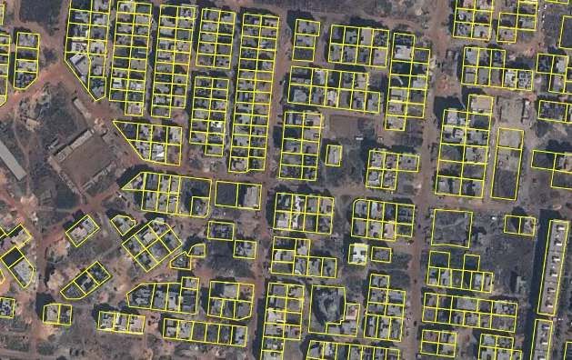
Confidential
Examples of land monitoring based on high and medium
resolution satellite imagery.
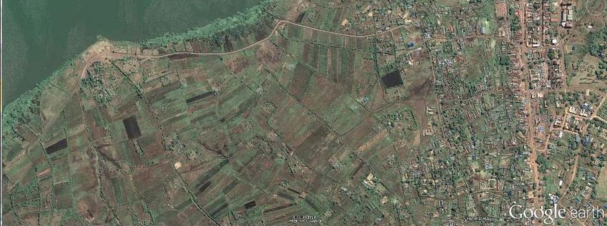
The city government of Dakar, Senegal, has a requirement to generate revenues for developing
and maintaining city infrastructure and services. Using very high resolution satellite data the land
parcels and building extents (including heights) can be monitored through a combination of 3D
image analysis and field data collection. This project provides the framework for field teams to
collect and maintain an accurate database of property, thereby enabling tax calculations to be
made in order to support sustainable and transparent revenue generation for the City.
Both Ethiopia and Kenya are flood and drought prone with significant mortality and economic
losses attributed to these events in each country. This project focuses on building resilience to
these events in order to both lessen risk and support economic growth. In Ethiopia it will focus on
building an improved understanding of flood and drought hazards and risks. In Kenya it focuses on
the effectiveness of EO data for the micro-insurance market and Government Institutions; an
important tool for farmers who currently have little or no access to insurance.
3 7 May, 2019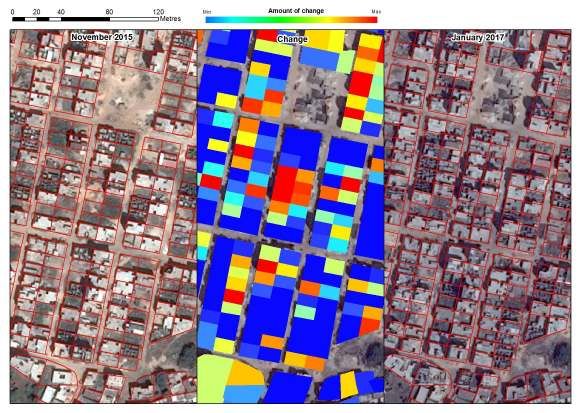
Confidential

Satellite image analysis for operational maintenance of a
property database for Dakar
    The partners:

    Airbus Defence and Space: project lead

    New Africa Consulting: local partner
    Experienced in geospatial data handling,
    education and local language

    United Kingdom Space Agency:
    funder and programme manager
4        7 May, 2019
Confidential

Dakar Change Monitoring Project (Dakar IPP Project)
    The principal objectives of this project are to:
    • Demonstrate and prove that change monitoring of land and buildings from satellite data can be
      fully incorporated into a procedure for generating property-based tax revenues;
    • Assist development of an operational property revenue system for Dakar City;
    • Focus on training and knowledge transfer to ensure that future operations can be fully
      implemented by a local technical team;
    • Develop a methodology that can be rolled-out to similar cities where infrastructure and services
      can be improved and enhanced by local revenues generated from a property-based tax system.
    Components:
    • Development of a technological application
    • Training / Learning by doing
    • Development of a methodology for the maintenance of the database over time

5         7 May, 2019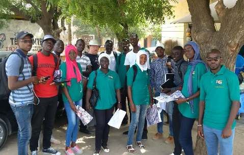
Confidential

Dakar IPP Project: progress highlights
    Acquisition of Imagery
    • Two sets of Airbus Elevation1 product (ortho-image & height data) covering Dakar received; new
      image data in preparation

    Software Development
    • Change detection software development completed for first release, with promising results.

    Local staff training & operations
    • Team of 14 staff trained in land parcel data capture. Work instructions evolved through training.
      Production well advanced and all target areas now completed.

    Mobile Data Capture
    • Preparations completed for mobilisation for training local team in mobile data capture. Mobile
      application prepared and deployed on tablets for training followed by data capture in the field.
6         7 May, 2019
Confidential

Dakar IPP Project: Land parcel capture

    • Training in image interpretation
      techniques

    • Techniques applicable to both
      aerial images and satellite

    • More than 64,000 land parcels
      mapped to date

    • The objective is a team of qualified
      technicians

7         7 May, 2019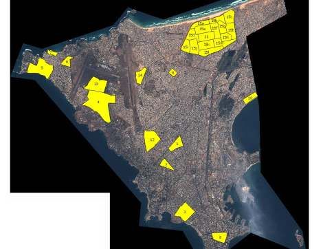
Confidential

    Dakar IPP Project: Land parcel capture
    Training mission May/June 2017 : Data collection

                         Training                      Field verification

8          7 May, 2019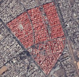
Confidential

Dakar IPP Project: Land parcel capture

    Parcel boundaries
    in a new
    development zone

9      7 May, 2019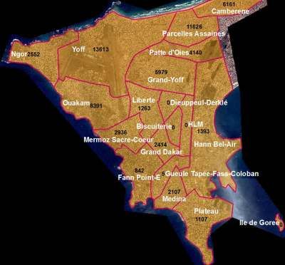
Confidential

Dakar IPP Project: Land Parcels Collected

10   7 May, 2019
Confidential

Dakar IPP Project: Software Application
 Software Application developed for first stage testing
 • Change detection run against 2015 and 2017 data; new
   image data acquired in September
 • Image and height change incorporated into change
   algorithms
 • Key features of software:
    • Parallax correction – adjustment of every and parcel
      according to detected parallax shift
    • Shadow detection and masking

11      7 May, 2019
Confidential
Dakar IPP Project: Change detection analysis
Locating
areas of
change
12 7 May, 2019Confidential
Dakar IPP Project: Change detection analysis
Change of
height
13 7 May, 2019Confidential
Dakar IPP Project: Reference Data
• Training mission in July 2017
• Training based on manual, updated with input from local team
• Training provided on Samsung Galaxy tablets operating Arc
Collector data collection software customised for the project
• Practice data capture local to NAC offices, data syncing to server
online under trainer supervision
• Roll out of data collection across target sites
• Following training NAC teams working independently with no
Airbus supervision
• Teams working in morning and afternoon shifts, to maximise data
capture within limited window
• Simplified specification being used when access to properties is
difficult; still captures enough information to verify property
changes
14 7 May, 2019Confidential Dakar IPP Project: First Change Detection Change Analysis • Output of test change analysis has been manually reviewed against imagery to generate training dataset for fine-tuning and onward development of the change software • New Imagery acquisition from September 2017, • This is being used for change detection vs January 2017 data • Results of change detection analysis will be compared with output from the manual assessment for accuracy analysis Field Verification • The NAC team are currently collecting full field data for a sample area in Grand Dakar • This area is where pilot work was done late last year, where we have previous field data • Assessment between the two field data will be done to assess success of image change detection process 15 7 May, 2019
Confidential

Dakar IPP Project: First Change Detection
 Field Verification contd..
 • The Grand Dakar area is of particular interest to DGID having already surveyed the area themselves
 • Current data capture is being done in accordance with simplified valuation model
 • This simplification is speeding up data collection considerably allowing over double the number of
    properties to be collected.
 • Data synchronisation working well after initial difficulties

16      7 May, 2019
Confidential
Dakar IPP Project: Valuation Modelling
• We are trialling a simplified valuation model potentially to be used for
valuing properties in Senegal.
• Originally the model could have required up to 200 attributes collecting for
a typical sized property with attributes being required for every room.
• The new model ultimately requires no internal inspection of properties.
• This means that the potential take up of the techniques we are developing
through this project is much more likely.
• Information now is only needed for:
• Building extents
• Neighbourhood
• Building class
• Age
• Condition/Upkeep
• Plumbing (y/n)
• Lift (y/n)
17 7 May, 2019Confidential
Dakar IPP Project: Valuation Modelling
• With the new valuation model, it is now much easier to make
an assessment of property values on an individual basis, as
well as on a whole district basis.
• To make these assessments we can use:
• Building data provided by ANAT/DTGC,
• Land parcel data as captured by NAC,
• Building Height data derived from DSM – DTM
• Information on land rates as provided by DGID for
different districts in Dakar.
• Then we can make observations on the building category,
condition, age, etc.
18 7 May, 2019Confidential Dakar IPP Project: Valuation Modelling • Using this data we will be able to make an initial broad assessment of total property values across Dakar. • Based on this and the existing rates of taxation the total potential revenue for Dakar can be calculated • Current estimates of 50M€ to 100M€ revenue will be refined in the next project period • The change methodology will help to ensure that the property database is up-to-date and accurate for all citizens 19 7 May, 2019
Confidential

Dakar IPP Project: next steps
     Testing of image classification
     • Comparison of the results of image analysis with data collected in the field
     Development of an operational system for data maintenance
     • Operational procedure for image analysis and field data collection
     Monitoring and evaluation of project impacts
     • Assessment of the long term impacts of having an accurate and maintained property database
       for Dakar
     Development of a road map for future exploitation
     • An operational image analysis procedure to improve the efficiency of maintaining a property
       database

20         7 May, 2019
The rainbow over our farms
A satellite-based resilience strategy
for drought and floodsIPP (International Partnership Programme)
Ethiopia-Kenya Project
Project Lead
Project Consortium
Ethiopia:
Kenya:
UK:
Funded byIPP (International Partnership Programme) Ethiopia-Kenya Project Aim: use satellite-derived index values to develop a Dashboard that can be used to improve drought resilience at a basin level in Ethiopia and a local level in Kenya. Dashboard is a web-based tool based on satellite data, modelled data, local data and contextual data. Two market sectors are identified: ➢ Micro-insurance ➢ Governmental institutions
2017 Drought
Year               Floods                                                          Drought                                    People affected

1961               Uhuru Floods
1968               Several events affecting Horn of Africa, Ethiopia,                                                         Millions
1977/78            Lake Victoria basin and the coastal areas of the Athi,
1982               Lamu and Tana River basins.
1985
1990
1975               Several events affecting East Africa Region                     Several events widespread                  Millions
1977
1980
1983/84
1991/92                                                                            Arid and semi-Arid districts of NE, Rift   1.5 Millions
                                                                                   Valley, Eastern and Coast
1995/96                                                                            widespread                                 1.41 Millions

1997/8             El Nino Floods                                                                                             1.5 Millions

1999/2000                                                                          widespread                                 4.4 Millions

2003               Eastern Province at Budalang’i and the lower
                   reaches of the Nzoia River and in Nyanza Province
                   at Ahero
2004                                                                               widespread

2011                                                                               Regionwide

2012               Nationwide

2016/17 Source : Republic of Kenya (2004), National Policy on Disaster Management (Revised
                                                                                   Kenya, Draft) p4, Nairobi, Kenya.
                                                                                           23 counties
How can we build drought/flood resilience?
…hope!
Improved weather
forecasting
Improved farming
techniques
Crop Insurance
Improved water management
techniques
Irrigation
Resilience planning/investment
Water InfrastructureHelp from satellite technologies
From space…
…to maps of our Earth!How the satellites detect drought
satellite
VHI: Vegetation Health Index
National VHI Map VHI is calculated for each 10x10m pixel with a
combination of Vegetation and Temperature
information.
Index value ranges from:
1 = good conditions (blue - green)Field-level data
Availability of field-level data:
• Every 10 days, 20 m resolution
• Throughout the growing season
• In the past (from the ‘80s at coarse resolution)
• In the future (early warning at flowering time)
Homa BayThe Dashboard (1) The Dashboard is a username and password-protected, responsive website made available over the secure https protocol. It comprises a Map Data Portal that gives users the ability to discover, view, query, download and print: • Drought Maps created regularly from satellite data by Airbus • Flood Model Maps created by Oxford University • Baseline Map Data from Kenyan sources Insurers can use the Dashboard in support to: • develop a new crop insurance product • manage their farm portfolio • manage insurance claims
A traditional vs. modern insurance system
     Traditional insurance system

Registration in the       Flood/drought       The farmer claims:      The insurance calls     The surveyor        If approved the
insurance scheme          damage              insurance paperwork     out a surveyor          issues a report     insurance pays out

      Modern insurance system

    Registration in the       Flood/drought           The map is a claim, a survey and a report: all in         If approved the
    insurance scheme          damage                                                                            insurance pays
                                                                           one!
                                                                                                                out
The Dashboard (2) The Dashboard will also serve the Governmental institutions such Ministries of Agriculture in Ethiopia (e.g. ATA, CRGE, etc.) and in Kenya (e.g. NMDA) with the following functionalities: • See how healthy the crops are countrywide, now and in comparison with the past • Easy decision making for the government • View basic thematic maps (e.g. Land use/cover, cropland, etc.) • Output reports in the form of maps, statistics and plots, at Woreda and sub-woreda level • Download and print out mapping data • Manage their own user information, including setting up of alerts
Benefits from a new high-tech system (1)
Survey with satellite
• A new job! Opportunity for women
• The project includes training for local operators
• Crops monitored every 10 days
• Maps at 20 m resolution
• Satellites are impartial: corruption free

                                                      Farmers
                                                      • Finally an affordable insurance!
                                                      • Satellites do not cheat
                                                      • Early warning of crop failure
                                                      • Automated
                                                        Claims/Payouts/Reports
Benefits from a new high-tech system (2)
Micro-insurances
• Regional coverage, not just around met stations. So a bigger market is reached
• Different perils (e.g. flood, pests, etc.) covered.
• The overall micro-insurance scheme is cheaper and simpler to operate: no surveyor visits, no met
station maintenance, no paperwork for claims & payouts
• Crop Insurance premiums cheaper than traditional insurance.
Government
• Potential nation wide coverage
• Early warning of drought events (alert already at flowering time)
• Flood modelling
• Regular, consistent outputs (maps, statistics and plots, at county
and sub-county level)
• Easy decision making about where to address international aid
• Applications also on livestock in grazing landsThank you
You can also read