Research on Navigation Safety of FPSO Towing Operation
←
→
Page content transcription
If your browser does not render page correctly, please read the page content below

IOP Conference Series: Earth and Environmental Science

PAPER • OPEN ACCESS

Research on Navigation Safety of FPSO Towing Operation
To cite this article: Zhao Changjiu et al 2021 IOP Conf. Ser.: Earth Environ. Sci. 809 012006

View the article online for updates and enhancements.

 This content was downloaded from IP address 46.4.80.155 on 22/09/2021 at 14:22
2021 8th International Conference on Coastal and Ocean Engineering IOP Publishing
IOP Conf. Series: Earth and Environmental Science 809 (2021) 012006 doi:10.1088/1755-1315/809/1/012006

Research on Navigation Safety of FPSO Towing Operation

 Zhao Changjiu1*, Zhang Wenjun1, Chen Changyuan2, Zhao Qingtao1 and Xiao
 Bai3

 1 Navigation College, Dalian Maritime University, Dalian 116026, China
 2 Ghent University, Ghent, Belgium
 3 Dalian Port Pilot Station, Dalian, China
 E-mail: 18900982611@163.com

 Abstract. In order to avoid and reduce the impact of water and underwater activities on
 navigation, maintain navigation order, protect ocean resources, ensure navigation safety, and
 promote the development of water transportation economy. Through the investigation and
 analysis of the project and the scientific evaluation method, the navigation safety of the ships
 involved in the project under the relevant water environment is analyzed and studied. Taking
 "Petrobras 76" as an example, the safety of towing is evaluated from the aspects of Meteorology,
 hydrology and local waterway conditions. Combined with the specific implementation scheme
 of the project, targeted risk assessment research is carried out. Finally, from the perspective of
 ship navigation safety, the rationality of the project design scheme is comprehensively evaluated,
 and the relevant safety is proposed Countermeasures, measures and suggestions for navigation.

1. Introduction
In the future, energy acquisition will be mainly concentrated in the ocean. Floating production storage and
Offloading Unit (FPSO) is the mainstream facility for offshore oil and gas production, storage and
transportation. Due to its lack of self-propelled ability, FPSO needs to be towed by high-power tugs from the
port to the sea area [1]. In the process of FPSO towing, due to the influence of wind, wave, current and other
environmental factors, the situation of yaw and sway endangering the towing safety often occurs. However,
the crew often take countermeasures based on experience, which lacks a certain theoretical basis [2].
The “Petrobras 76 (P76)” is a FPSO refitted by Dalian COSCO Shipping Engineering Co., Ltd. from VLCC,
and has no self-propelled capability. The P76 ship of the project is planned to leave the COSCO Shipping
terminal, and use the tug designated in port to tow it to the eastern water area of the anchorage of the first
cargo ship in Dalian port (38°56′16″N, 121°44′40″E), and then connect the tow cables of two foreign
oceangoing tugs. After the connection, the P76 will be towed to the designated waters outside the port
boundary for ballast. After the draft reaches 10.5 meters, it will be directly towed to Rio de Janeiro, Brazil
[3]. The tow organization chart is shown in Figure 1.

 Content from this work may be used under the terms of the Creative Commons Attribution 3.0 licence. Any further distribution
 of this work must maintain attribution to the author(s) and the title of the work, journal citation and DOI.
Published under licence by IOP Publishing Ltd 1
2021 8th International Conference on Coastal and Ocean Engineering IOP Publishing
IOP Conf. Series: Earth and Environmental Science 809 (2021) 012006 doi:10.1088/1755-1315/809/1/012006

 PTOPL PTOPL
 TUG2(SALVANGURAD) TUG2(SALVANGURAD)

 COAST STATIONS
 WEATHER
 FORECAST
 PROVIDER
 PROJECT MANAGER
 ENSEADA ALEX RODENBURG
 INDUSTRIAL NAVAL
 S.A.
 PROJECT MANAGEMENT TEAM
 COSCO SHIPYARD AGM(OPS AND PRJ EXECUTION)
 CART.KENNETH BALES
 MANAGER(COMMERCIAL)
 MWS AM(OPS AND PRJ EXECUTION)

 PTOPL AGENTS EEP AGENTS
 (Dalian) (Dalian) PROJECT SUPPORT TEAM
 PTOPL AGENTS EEP AGENTS HSEQA DEPARTMENT
 (Singapore) (Rio De POSH FLEET SERVICES
 Janeiro) TECHNICAL SUPERINTENDENT(VESSELS)
 PTOPL AGENTS SINGAPORE OIL SPILL RESPONSE CENTRE
 (Mauritius) (SOSRC)
 PTOPL AGENTS
 (Rio De Janeiro)
 PROJECT DIRECTOR

 Figure 1. Tow organization chart of this project.

2. Towing force calculation and towing scheme

2.1. Towing force calculation
According to Classification Society of China guidelines for towing at sea, the total resistance of sea towing
can be calculated according to the following empirical formula:
 ∑ = 1.15[ + + ( + )] (1)
where: Rf is the friction resistance of towed ship; RB is the residual resistance of towed ship; Rft is the friction
resistance of tugs; RBt is the residual resistance of tugs.
1) Towing resistance
The resistance of the towed ship or object is determined by the following approximate methods:
 = 1.67 1 1.83 × 10⁻³ (2)
 = 0.147 2 1.74+0.15 (3)
where 1 represents the underwater wet surface area of a ship or a structure over water; is the towing
speed; is the block coefficient. 2 represents midship cross section area of submerged part.
2) Towing resistance
Several tugs will be used in the actual towing operation. Since the tugs are basically similar in ship type and
resistance, the resistance of tugs can be determined by tug design data. If there is no data available, an
approximate calculation can be made according to the design data of the tug.
The ship may encounter the situation of wind and current in the towing process. The towed ship can only
overcome the wind and current by relying on external force, so as to ensure that the ship does not “lose its
position”. The wind and current force can be calculated by using the formula of wind force and flow force.

∑ = ( × × 2 sin2 × + × × 2 sin2 × × ) × 10−3 (4)
 2

∑ = ( × × 2 cos 2 × + × × 2 2 × 1 × ) × 10−3 (5)
 2
where ∑ is the transverse wind force (KN); ∑ is the Longitudinal wind force (KN); is the wind
power coefficient; is the hydrodynamic coefficient; is the projected area of hull side above waterline
(m2); is the ship waterline length (m); is the projected area of hull front above waterline (m2).
Because there are many hydraulic structures in the harbor area, especially the narrow water area in the

 2
2021 8th International Conference on Coastal and Ocean Engineering IOP Publishing
IOP Conf. Series: Earth and Environmental Science 809 (2021) 012006 doi:10.1088/1755-1315/809/1/012006

channel, if only considering the towing resistance in the forward direction of the ship, the resistance caused
by wind and current may cause the ship to deviate from the course and run aground. In order to avoid the
towing ship yawing, the towing force provided by the tug in the direction perpendicular to the channel must
be balanced with the wind and current force in same direction.
Namely, the towing force required in the forward direction (i.e. longitudinal direction) should be at least
balanced with the sum of the resistance of the tug and the towed ship in that direction as well as the wind and
current force; the towing force required in the vertical and forward direction (i.e., transverse) should be at
least balanced with the wind and current force in that direction. According to navigation experience and
towing practice, 20% reserve towing force should be reserved, Therefore, the total towing force required for
towing operation can be calculated by the following formula [4].
The longitudinal towing force required for towing is the total thrust of the main tug:
 ∑ = 1.38[ + + ( + )] + 0.6 ( × × 2 cos 2 × + × × 2 2 ×
 1 × ) × 103 (6)
Transverse towing force required for towing operation:
∑ = 0.6 ( × × 2 sin2 × + × × 2 2 × 1 × ) × 103 (7)

2.2. FPSO information
Table 1 shows the information of the FPSO which in this project going towing.
 Table 1. The information of the FPSO.

 Items Values Units Items Values Units
 Total length 332 m total ton 164980
 Width 58.00 m Sea towing draft 10.5 m
 Draught 6.621 m towing draft in port 6.5 m
 Net ton 97671 length between perpendiculars 320.792 m
 depth 28.10 m

2.3. The tug information
The towing operation in the port of this project is jointly undertaken by six harbor tugs, and the main engine
horsepower of each tugboat shall be no less than 4200hp. In addition, one tugboat is required to undertake
the escort mission.
Two foreign ocean going tugs are responsible for the sea towing operation of the project.

2.4. Towing arrangement
The main towing arrangement are shown in Figure 2.

 Figure 2. Main Towing Arrangement.

2.5. Towing operation process
The COSCO Shipping pilot and the pilot of Dalian Port pilot station boarded the P76 ship at the shipyard
wharf, and the COSCO Shipping pilot was responsible for towing the P76 from the wharf to the yard turning
area of COSCO Shipping.
The pilot of Dalian Port took over from the turnaround area of the shipyard and was responsible for directing
the towing of the P76 to the eastern waters of the anchorage of the first freighter in Dalian port (38°56′16″N,
121°44′40″E).

 3
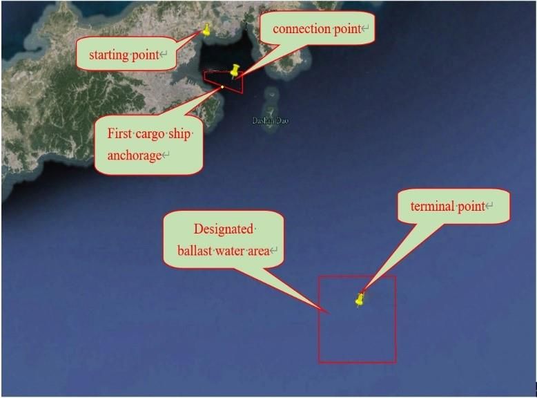
2021 8th International Conference on Coastal and Ocean Engineering IOP Publishing
IOP Conf. Series: Earth and Environmental Science 809 (2021) 012006 doi:10.1088/1755-1315/809/1/012006

In the eastern water area of the anchorage of the first cargo ship, the pilot of Dalian Port pilot station, with
the assistance of tugs in the port, monitors the connection process of tow cables of two foreign oceangoing
tugs [4].

 Figure 3. Schematic diagram of starting point and ending point of towing operation.
After the towline connection is completed, under the escort of tugboat in port, the pilot of Dalian port will be
responsible for directing the foreign tugboat to tow P76 out of the port. The pilot disembarked at the departure
point (38°53′N, 121°44′5″E) of Dasanshan waterway, and the foreign tugboat towed the P76 to the designated
ballast water area outside the port boundary. It is planned that after 2-3 days of ballast operation, the P76 ship
will be towed to Brazil by two foreign tugboats.
The starting point of towing in the port of the project, the connection point of foreign ocean tug's towing
cable and the terminal point of towing in the port (i.e. the designated ballast water area) are shown in Figure
3.

3. Analysis of interaction between towing operation and natural environment

3.1. Wind effects
The sea area belongs to East Asian monsoon region, with significant seasonal changes, with the south wind
in summer and northerly in winter. Table 2 shows the wind derection frequency from 1951 to 2003, the
normal and secondary wind directions in this area are N and S, with the frequency of 15% and 12%
respectively. The strong wind direction is N, and the frequency of wind with the direction ≥ 6 is 1.99%. The
frequency of wind occurrence in all directions ≥ 6 and ≥ 7 is 4.62% and 1.65% respectively, which is
converted into 17 days and 6 days in the whole year. The maximum wind speed in N direction is 34m/s,
which occurs in April 1964 and March 1965.

 Table 2. Wind direction frequency from Dalian meteorological station (1951 – 2003) (%).
 N E E S S W W N
 Wind N S S N dominant
 N N N E S S S S S W N N C rate
 Direct E E W W direction
 E E E E W W W W
 Hole
 15 4 2 2 3 3 6 8 12 9 5 3 3 3 7 11 4 N 15
 year
When the wind force acts on the ship, it will produce wind-induced deflection, wind-induced drift and so on.
Before the towing of the project, the weather conditions that meet the towing conditions should be selected
according to the weather forecast. If the towing conditions cannot meet the requirements, the start date of
towing should be adjusted according to the weather forecast. In case of strong gust during towing, the wind
pressure difference should be correctly pre allocated according to the wind direction and intensity, and the
ship should be operated carefully to ensure the safety of towing operation.

3.2. Wave influence
The frequency of wave influence is low, especially when the wave height is greater than 1.0 m, only 0.54%.

 4
2021 8th International Conference on Coastal and Ocean Engineering IOP Publishing
IOP Conf. Series: Earth and Environmental Science 809 (2021) 012006 doi:10.1088/1755-1315/809/1/012006

The wind waves in the small wind area of Dalian Bay are mainly affected by the directions of WSW, W and
WNW.
Large waves have a great impact on the towing operation, and the wave height shall not exceed 1 m when
the project starts towing from the shipyard [5].

3.3. Current influence
The tidal current in Dalian Bay goes deep in counterclockwise and clockwise at high tide and low tide
respectively. At high tide, the tidal current enters from Dagushan sea area, and part of the water flows into
each sub Bay after entering the Bay, and most of the water body flows to the tiger beach sea area after
reaching the middle of the bay.
The sea area belongs to the irregular semi diurnal tidal current area. The periods of the twice daily rising and
falling tides are different, and the tidal current intensity is also different, one strong and one weak.
According to the chart data, the current velocity of rising tide is about 1kn, and that of ebb current is about
1.5 kn. The larger current changes the speed of the ship, and also causes the ship to deviate from the planned
route or to roll and drift. During the towing operation, we must be cautious, pay attention to safety, correctly
pre allocate the flow pressure difference, control the heading and avoid yaw.

3.4. Fog influence
Fog days (including cloudy days, rain and snow) with visibility less than 1km are mainly from April to July.
When the project is towed from the shipyard, the visibility must be greater than 3000m. In case of heavy fog
during towing operation, relevant regulations shall be strictly observed, fog signal shall be sounded according
to regulations, and safe speed shall be adopted to ensure towing safety.

4. Navigation safety assessment of towing operation

4.1. Estimation of water depth required for towing operation
The towing draft of P76 wheel of the project is 6.5 m, and the required towing depth is 7.15 m based on 10%
surplus water depth.
Except for the waters near COSCO’s turning area, the water depth of the other sections is greater than 7.15
m, meeting the towing requirements.
The shallowest water depth near COSCO’s turning area is 5 m, and the P76 needs to ride the tide for 2.15 m.
The tidal water level in Dalian Bay is 2.45 m with a guarantee rate of 90%, which meets the towing
requirements of the project. Towing can be arranged before the high tide to ensure the safety of towing.
According to the tide table of navigation Guarantee Department of the Chinese People's Liberation Army
command, the tide situation of Dalian port from October 23 to 27, 2014 is shown in Table 3.

 Table 3. The tide situation of Dalian port (2014.10.23~28).
 When the tide height is 2.15 m in the
 data time of tide height of tide
 morning of that day
 0407; 0955 0.37; 2.60
 10.23 0734~1234
 1610; 2218 0.28; 2.92
 0442; 1024 0.41; 2.63
 10.24 0839~1218
 1641; 2246 0.33; 3.06
 0515; 1053 0.51; 2.68
 10.25 0902~1254
 1711; 2314 0.38; 3.17
 0549; 1124 0.57; 2.68
 10.26 0932~1325
 1743; 2345 0.38; 3.20
 0626;1159 0.58; 2.60
 10.27 1015~1350
 1818 0.31
 0023; 0706 3.15; 0.53
 10.28 1112~1411
 1239; 1856 2.46; 0.24

4.2. Estimation of required width for towing operation
According to the actual situation of tugboat configuration of the project, during the towing process of P76 in
COSCO Shipping Channel, as there are auxiliary tugs on both sides of P76 to assist in controlling the ship

 5
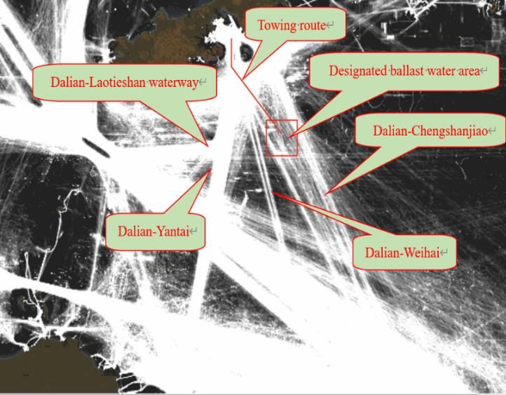
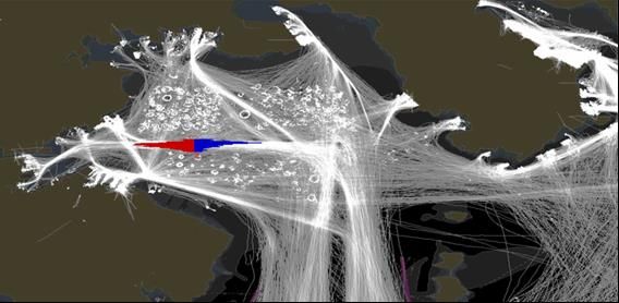
2021 8th International Conference on Coastal and Ocean Engineering IOP Publishing
IOP Conf. Series: Earth and Environmental Science 809 (2021) 012006 doi:10.1088/1755-1315/809/1/012006

position, the actual dimensions of P76 and its auxiliary tugs on both sides are used to check the required
water area width for towing operation [6].
If the captain of port tug is 35 m and the width of P76 ship is 58 m, the width of water area required for
towing combination is calculated as follows:
 (35 + 15) × 2 + 58 = 158
If P76 is kept in the middle of the channel, there are still 21m channel surplus widths on the left and right
sides of P76. This shows that the 200 m wide channel of COSCO Dalian can meet the needs of safe towing
of P76.

4.3. Assessment of designated ballast water area
The designated ballast water area of the project is located between the encountering rock and the circular
island, which is a square area with a side length of about 8 nautical miles. The nearest distance between the
ballast water area and the encountering rock area is about 13’52, and the nearest distance to the round island
is about 3’45.
The customary route near the designated ballast water area of the project is shown in Figure 4. The ballast
waters are designated to avoid the customary routes of Dalian Laotieshan waterway, Dalian to Yantai
waterway and Dalian Weihai waterway, which have little influence on the customary navigation routes of
Ro-Ro ships in Dalian Yantai direction and Dalian Weihai waterway. However, the designated ballast water
area of the project is located on the customary route of Dalian to Chengshanjiao, which has a certain impact
on the passing ships on the customary route from Dalian to Chengshanjiao. In this project, tugboat monitoring
measures can be taken in the port, and ships passing by can avoid the designated ballast water area to ensure
the safety of ballast operation.
Therefore, the designated ballast water area is appropriate under certain conditions [7].

 Figure 4. Customary route near designated ballast water area.

4.4. Depth assessment of designated ballast waters
The draft of P76 ship in this project needs to be adjusted from 6.5m in harbor to 10.5m at sea in designated
ballast water area.
In the designated ballast water area of the project, the shallowest water depth is about 47m, meeting the
ballast requirements of P76 wheel.

4.5. Analysis of influence of towing operation on navigation safety and environment
The towing route of the project crosses the northeast corner of the oil tanker anchorage, the southwest corner
of the second cargo ship anchorage and Ganjingzi channel. The ballast operation occupies a certain range of
water area. The ship traffic flow on the towing route and the designated ballast water area is relatively dense,
and the towing operation and ballast operation have a certain impact on the past ships. According to AIS
statistics, in 2012, the vessel traffic flow of Ganjingzi channel was 2891, and the average daily flow was
about 7.9. Among them, oil tankers and non-transport ships account for a large proportion, accounting for

 6
2021 8th International Conference on Coastal and Ocean Engineering IOP Publishing
IOP Conf. Series: Earth and Environmental Science 809 (2021) 012006 doi:10.1088/1755-1315/809/1/012006

about 78% of the total, and the others are cargo ships and passenger ships. The AIS track distribution of ships
in Ganjingzi channel is shown in Figure 5.

 Figure 5. AIS track distribution of ships in Ganjingzi channel.

However, as the project is a temporary project, and the towing combination is only carried out along a single
planned route, the ballast operation is only limited to the designated water area, which will not increase the
traffic flow in the sea area and the designated ballast water area. The water area occupied by the operation at
a certain time only affects the navigation ships near the water area. As long as the safety measures are
implemented on the basis of the implementation of the international collision prevention rules, the impact is
controllable.
As the project is towing and ballast operation, no hydraulic structures will be produced after completion, so
the navigation safety of water area will not be affected after completion.

5. Conclusion
Towing operation of FPSO is a systematic project. Before towing, proper towing scheme and emergency plan
should be formulated to clarify the responsibilities and obligations of all parties involved in towing. Under
the premise of scientific management, strict organization and careful planning, according to the method
proposed in this paper, the risk can be minimized and the towing task of the project can be successfully
completed.

6. References
[1] WANG ke, XU Wang. Study of wave drift force affecting FPSO system[J]. Journal of Harbor
 Engineering University, 2008,29(12):1261-1265.
[2] MA Yande, GUAN Weishu, WANG Yanying Calculation of motion and loads for an FPSO in
 waves[J].Journal of Harbor Engineering University, 2005, 26(4):445-450
[3] Mei Yingqun. Feasibility study of towing floating oil storage tanker in narrow channel [J].
 Navigation technololgy, 2009 (1): 2-4.
[4] Yao J, Han D, Zhao P. Research on the Simulation of Ship Towing System[J]. Shipbuilding of
 China, 2011, 52(3): 74-82.
[5] XIE Yonghe, XU Jinsong, LI Runpei. Wave induced loads on very large FPSOs at restricted water
 depth[J]. China Ocean Engineering, 2005,19,19(2):215-224.
[6] Kim M H, Koo B J, Mercier R M, et al, Vessel/mooring/riser coupled dynamic analysis of a turret-
 moored FPSO compared with OTRC experiment[J]. Ocean Engineering, 2005,32(14):1780-1802.
[7] Lu Xiaodong. Some issues to be paid attention to in large-scale towing operations at sea [C]
 proceedings of the Symposium on marine pollution prevention and emergency technology, 2009:
 149-153.

 7
You can also read