Experiment of Sea Breeze Convection, Aerosols, Precipitation and Environment (ESCAPE) - Radar Science
←
→
Page content transcription
If your browser does not render page correctly, please read the page content below

Experiment of Sea Breeze Convection, Aerosols,
    Precipitation and Environment (ESCAPE)
PI: Pavlos Kollias, Co-I Mariko Oue (Stony Brook)
       Field campaign management, radar meteorology, SBU mobile trucks
       microphysics and dynamics of convective clouds, urban boundary layer

Co-I’s
Matthew Kumjian and Kelly Lombardo (Penn State)
       Radar polarimetry, microphysics/dynamics, drifter sondes
Eric Bruning (Texas Tech) and Timothy Logan (Texas A&M)
       Houston LMA operations, Lightning and mixed phase microphysics
Zachary Lebo (Wyoming) and Sue van den Heever (Colorado State)
       High resolution modeling, updraft properties, aerosols and meteorology
       controls on deep convection, cold pools
Greg McFarquhar (Oklahoma)
       Aerosol-cloud microphysics, aircraft operations
Greg Roberts (Scripps Institution of Oceanography)
       Analysis of mini-CCNc’s data and aerosol-convection interactions
Raymond Shaw (Michigan Tech)
       Analysis of HOLODEC-II observations, entrainment and cloud microphysics
 +
 Paul Lawson (SPEC Inc.) - SPEC Learjet 35A operations & C-130 user-supplied probes
 Paul DeMott (Colorado State) - C-130 user-supplied probes
 V. (Chandra) Chandrasekar (Colorado State) – C-band radar
 Jeffrey Snyder and David Bodine (Oklahoma/NSSL) - 2 mobile X-band radars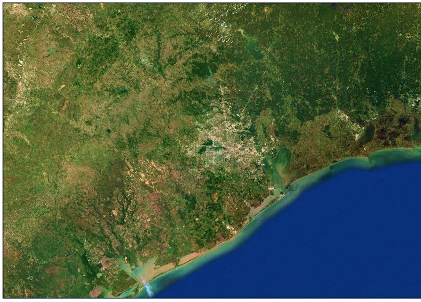
ESCAPE Science Focus Areas
•   Investigate the control of meteorology, dynamics, and mixing on aerosol indirect effects on the early growth stage of
    convective clouds,

•   Characterize the environment and physical processes leading to coastal convective initiation,

•   Determine how mature convective updraft microphysical and kinematic properties relate to those earlier in the
    cloud lifecycle, its initiation mechanism, and heterogeneities of its parent environment

•   Quantify environmental thermodynamic and kinematic controls on convective lifecycle properties under different
    aerosol conditions.

•   Quantify: (1) how cold pool properties and lifetimes vary as a function of precipitation amounts and precipitation
    size distributions, and how are these relationships modulated by the relative humidity,(2) what is the impact of
    aerosol number concentration on cold pool depth and intensity, and (3) how do different land-surface types
    determine the dissipation of cold pools.

•   Characterize how the lightning flash size and energy depends on the modification of the supercooled liquid water
    content, scale and volume of the mixed-phase updraft, and hydrometeor populations.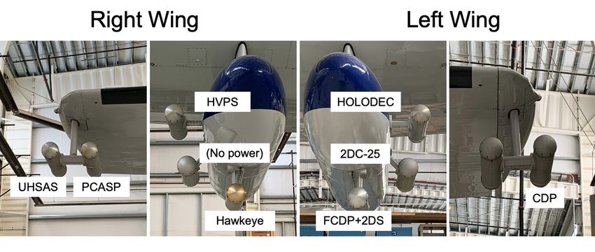
ESCAPE
 Experimental
 Design
In order to address the
scientific objectives,
observations of the various
physical mechanisms within
the clouds and local
environment that act to                                Evaporation
produce precipitation are
needed. This includes the
cloud microphysical
properties and the vertical        ESCAPE measurement requirements
motions within convective
storms that are associated
with heavy precipitation
                              Airborne campaign:       June 15 – July 15, 2021
                              Ground-based campaign:   June 10 – July 25, 2021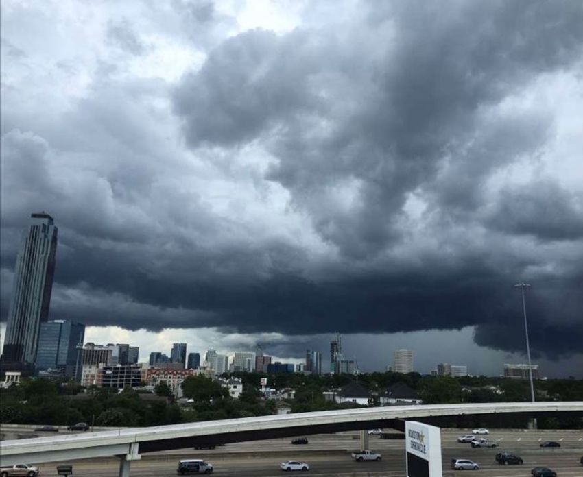
SPEC LearJet 35A
         32 research flight hours
         8 flights

         The SPEC Learjet will be equipped with
         state-of-the art in situ microphysical
         probes, air motion sensing and a Ka-band
         up/down radar.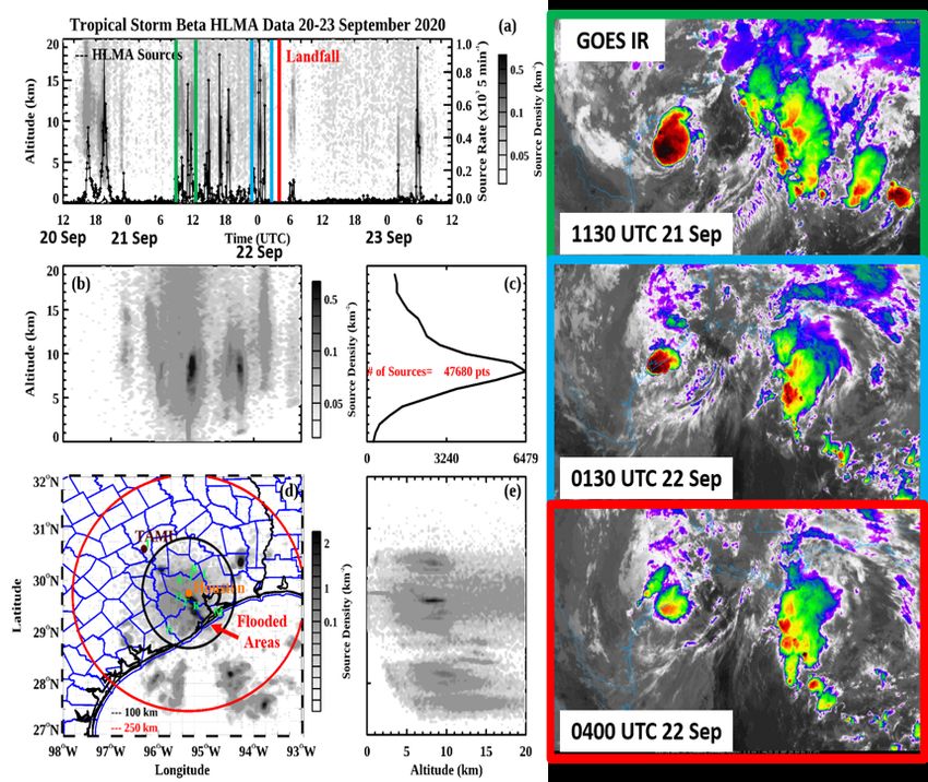
Equipment List                           Manufacturer                    Range               Accuracy

                Temperature                     Rosemount Model 102 & 510BH         -50 to +50 °C            0.5 °C

                   Altitude                        FAA RVSM Certification            45,000 ft           60 ft (18.3 m)

                  Airspeed                         FAA RVSM Certification          0 to 220 m s-1            1 m s-1

           Dew Point Temperature                EdgeTech Chilled Mirror C-137       -50 to + 50°C             1°C
             Cloud Liquid Water                    Sky Tech Nevzorov LWC            0 to 4 g m-3           0.05 g m-3

             Total Water Content                   Sky Tech Nevzorov TWC            0 to 4 g m-3           0.1 g m-3

                  Icing Rate                    Rosemount Icing Rod 871LM5              N/A          Sensitivity ~0.01 g m-3

               Aircraft Position                Aventech AIMMS-20 Dual GPS              N/A                  10 m

               Aircraft Heading                 Learjet Sperry Directional Gyro      0 to 360°                 1°

               Horizontal Wind                      Aventech AIMMS - 20              0 to 360°                 1°
                Vertical Wind                                                      1 to 100 m s-1            1 m s-1

                  Aerosols                                 PCASP                    0.1 to 3 µm              1 µm

   2D-S (Stereo) Optical Array Spectrometer         SPEC Model OAP 2D-S           10 µm to 3 mm             10 µm
                                                       2-D Gray probe
       Fast Cloud Droplet Probe (FCDP)              SPEC Model FCDP-100              2 to 50 µm              2 µm

High Volume Precipitation Spectrometer (HVPS)        SPEC Version-3 HVPS           150 µm to 2 cm           150 µm
                                                       Version-4 HVPS
             Combination FCDP,                          SPEC Hawkeye              1 µm to 6,400 µm   1 µm FCDP 10-50 µm
        10 and 50 µm 2D-S, V 2.5 CPI                                                                    2D-S 2.3 µm CPI

        Iso Inlet for aerosols < ~ 2µm                       DU                     0.01 to 2 µm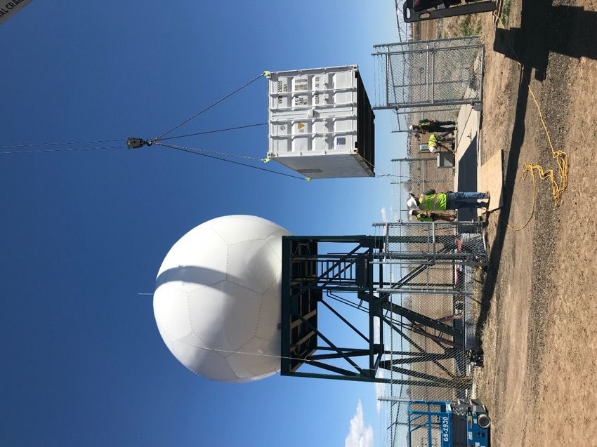
Ka-band Probe Radar (KPR)
NCAR C-130
                                       90 research flight hours
                                       15 flights

                                       The C-130 will be equipped with
                                       in situ microphysical probes,
                                       aerosol measurements of CCN,
                                       IFP and biological aerosols, air
                                       motion sensors and the
                                       University of Wyoming cloud
                                       resolving radar (WCR).

The NSF/NCAR C-130 is a versatile airborne research platform that is
well suited for studies of the middle troposphere. With its 13,000 lbs
payload capability and ~9 hour endurance, the C-130 is well suited for
a variety of research tasks that do not require reaching altitudes in
excess of 26,000 feet. With excellent low altitude performance the
C-130 is used extensively for studies of the planetary boundary layer.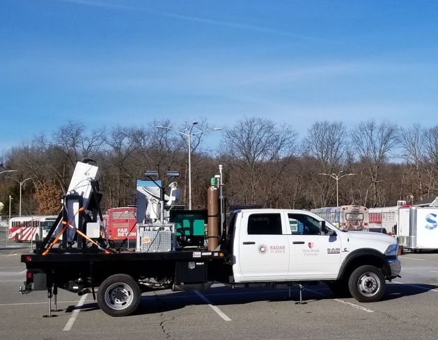

NCAR C-130 – Additional probes
Colorado State U. C-band Radar

Radar electronics packaged in a 20-ft shipping
container
Radome, positioner and antenna currently
mounted on a 20-ft tower (or 10-ft).
Platform and container sit on a 30-ft square area
(Concrete pad at CSU)
Platform legs have 3-6 ft deep concrete piers,
depending on soil conditions and height
Oklahoma U. Mobile X-band radars
 RaXPol          NOXP
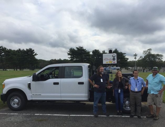
Stony Brook U. Weather Truck

                                               Parsivel Backscatter lidar Soundings
                           SKYLER:
                         Dual-pol X-band           Met Station   Micro Rain Radar
                        phased-array radar                            (MMRpro)
                XP
              NO

RaX
   Pol

            The OU mobile X-band radars along with the SBU-SKYLER will be used to establish a
            multi-Doppler network, with ~30-km baselines and volumetric scans every ~2 min to
            provide fine spatial-temporal scale sampling of evolving 3D structures from very near
            the surface to boundary layer or storm top

            The OU radars will focus on dual-Doppler analysis focusing on the low- and mid-level
            structure (0-6 km) and the SBU SKYLER will be positioned within the dual-Doppler
            lobe and cover the upper part of the convective clouds
Brookhaven NL Research Truck
Parsivel Backscatter lidar Soundings
Scanning Met Station Micro Rain Radar
Doppler lidar (MMRpro)
Characterize the cold pool www.bnl.gov/cmas
thermodynamical structure
Using the scanning Doppler lidar,
soundings, profiling radar/lidar,
disdrometer and surface meteorologyHouston Lightning Mapping Array (HLMA)
The Houston Lightning Mapping Array
(HLMA) was established in April 2012.
It is currently a network of 10 time-
of-arrival lightning sensors centered
on the Houston Metropolitan area
that provide 3D lightning information
to a range of 100 km and 2D mapping
and acceptable flash counts within a
250 km radius of the network center.
In preparation for ESCAPE, the Bay
City Airport Sensor (N) has been
added and all other stations (A, B, D, F,
I, J, K, L, and M) have been refreshed
to ensure quality 3D mapping and (Credit COD Weather for GOES IR imagery)
mapping of small flashes over HLMA captured
expected IOP domain. lightning activity during
Tropical Storm Beta.Radiosondes and Swarmsondes
32/IOP x 10 IOPs
200 DFM-09 Radiosondes
5 per IOP x 2 mobile trucks
20 IOP daysCloud Resolving Modeling
Surface potential temperature
Park and van den Heever 2020
Quantify environmental thermodynamic and kinematic controls on
convective lifecycle properties under different aerosol conditions.
Quantify: (1) how cold pool properties and lifetimes vary as a
function of precipitation amounts and precipitation size
distributions, and how are these relationships modulated by the
relative humidity,(2) what is the impact of aerosol number
concentration on cold pool depth and intensity, and (3) how do
different land-surface types determine the dissipation of cold pools.Multisensor Agile Adaptive Sampling (MAAS)
Software-defined convective cell tracking
using radar and non-radar data sources for
optimum resource allocation in the field
(i.e. airborne/ground-based platforms)
Input:
NEXRAD KHGX
TDWR TIAH
GOES-16 ABI (Ch. 2 & 13)
GLM Lightning data
Houston LMA
Kollias, et al., 2020: https://doi.org/10.1029/2020GL088440
Data gridding
Co-registration
Nowcasting
Convective cell(s) selection
Radar steering and sampling
Multiple outputs for distributed sensors networkExperiment of Sea Breeze Convection, Aerosols,
Precipitation and Environment (ESCAPE)
CSU C-band
La Porte Airport
Location of DOE/AMF
LearJet/C-130
NASA Ellington Airport
NASA Ellington Airport
La Porte Airport
Possible CSU
C-band locationExperiment of Sea Breeze Convection, Aerosols,
Precipitation and Environment (ESCAPE)
Houston – Galveston urban area
Dense industrial area
SBU X-PAR
OU X-band
CSU C-band
C-130/Learjet
A2 A3
A1Summary • The NSF-supported ESCAPE field experiment brings considerable observational capabilities in Houston • Coordination with DOE/TRACER and other agencies is highly desirable – Combine (coordinate?) observational resources – Delta-t measurements – Deployment preparation and logistics – Forecast – Soundings/Radars – Planning/science meetings
You can also read