FINDING OF EMERGENCY - State Water Resources Control ...
←
→
Page content transcription
If your browser does not render page correctly, please read the page content below
FINDING OF EMERGENCY
Executive Summary
The Sacramento-San Joaquin Delta (Bay-Delta) watershed, California, and the entire
western United States are facing a significant drought in the wake of one of the driest
periods on record, driven by climate change and extreme hydrologic conditions over the
past two years. Water supply in many parts of California, including the Mill Creek and
Deer Creek watersheds, is insufficient to meet a significant portion of water demands,
including ecological needs. Addressing the severe water shortage in the Mill Creek and
Deer Creek watersheds requires urgent action to ensure water supplies are and will
remain available to meet minimum instream flows for fish and to prevent the inefficient
irrigation of domestic lawns.

The Mill Creek and Deer Creek watersheds are tributaries to the Sacramento River
located in Tehama County, and the watersheds support multiple self-sustaining natural
populations of anadromous salmonids. These watersheds have been identified as high-
priority tributaries for the protection and recovery of wild populations of Central Valley
spring-run Chinook salmon (CV SR salmon) which are listed as threatened under the
federal Endangered Species Act (ESA) and the California ESA, and California Central
Valley steelhead (CCV steelhead) which are listed as threatened under the federal ESA.
NMFS and CDFW have recognized that protecting and restoring these populations as
significant to the recovery of these threatened species. As a result of low winter
precipitation for the second straight year, hydrologic conditions are very dry in the
Sacramento Valley and immediate action is needed to protect threatened fish species in
Mill and Deer Creeks.

The State Water Resources Control Board (State Water Board) finds that an emergency
exists due to severe drought conditions. Immediate action is needed to prevent the
unreasonable use of water diverted from priority water bodies that provide habitat for
threatened and endangered species in light of limited water availability during the
drought. The State Water Board will need to curtail water diversions in order of water
right priority, except to the extent water is needed for minimum human health and safety
needs, when natural flows decrease so that water is available to provide minimum flows
for migration of state and federally listed fish in the two Sacramento River tributaries,
Mill Creek and Deer Creek. Local cooperative solutions or voluntary agreements that
provide equivalent protections for sensitive fisheries may be implemented as an
alternative to the proposed emergency regulation. Additionally, it is necessary to prohibit
an existing practice of excessive water application for lawn irrigation, in light of the need
for water for other economic and ecological uses in this severe drought.
This document makes findings and provides evidence of the emergency drought
conditions in Mill Creek and Deer Creek watersheds, the State Water Board’s response
to the drought conditions in these watersheds (including outreach on voluntary efforts
and on the proposed regulation), and status of CV SR salmon and CCV steelhead. It
further makes findings and provides evidence regarding the need for the emergency
regulation, which includes an overview of the water rights framework, the need for
emergency protective minimum fishery flows, descriptions of the watersheds, and need
to limit inefficient water uses during current drought conditions. The document’s
informative digest section summarizes existing laws and regulations and provides a
policy overview and discussion of the effect of the proposed regulation. The document
concludes with a list of information relied upon, statements on CEQA exemption, and a
summary of fiscal costs. The Fiscal Impact Statement is included as Attachment 1.

As such, the document meets the requirements for a digest described in Government
Code section 11346.5, subdivision (a)(3).

Governor Newsom’s Drought Emergency Proclamations
On April 21, 2021, Governor Gavin Newsom declared a drought state of emergency
under the provisions of the California Emergency Services Act (Gov. Code, section
8550 et. seq.), in Mendocino and Sonoma counties due to drought conditions in the
Russian River watershed (April 2021 Proclamation). The April 21, 2021 proclamation
directs state agencies to take immediate actions to bolster drought resilience across the
state.
On May 10, 2021, Governor Newsom expanded the drought proclamation to include
counties within the Klamath River, Sacramento-San Joaquin Delta (Delta watershed),
and Tulare Lake watersheds (May 2021 Proclamation). To ensure critical instream flows
for species protection in the Klamath River and Sacramento-San Joaquin Delta
Watersheds, the May 2021 Proclamation directs the State Water Board and the
California Department of Fish and Wildlife (CDFW) to evaluate the minimum instream
flows and other actions needed to protect salmon, steelhead, and other native fishes in
critical streams systems in the State and to work with water users and other parties on
voluntary measures to implement those actions. To the extent voluntary actions are not
sufficient, the Proclamation directs the State Water Board, in coordination with CDFW,
to consider emergency regulations to establish minimum drought instream flows. The
May 2021 Proclamation also directs the State Water Board to consider emergency
regulations to curtail water diversions when water is not available at water right holders’
priority of right or to protect releases of stored water in the Delta watershed. For
purposes of approving these emergency regulations, the May 2021 Proclamation
suspends the California Environmental Quality Act (Pub. Resources Code, § 21000 et
seq.) (CEQA).
On July 8, 2021, Governor Newsom further expanded the emergency proclamation to
include nine additional counties (Inyo, Marin, Mono, Monterey, San Luis Obispo, San
Mateo, Santa Barbara, Santa Clara, and Santa Cruz) (July 2021 Proclamation).
Currently, a total of 50 of the state’s 58 counties are under a drought state of
emergency. Governor Newsom also signed Executive Order N-08-21 on July 8, 2021,
urging all Californians to voluntarily reduce their water use by 15 percent compared to
2020 levels (July 2021 Executive Order). The July 2021 Executive Order encourages
Californians to take actions to conserve water, such as irrigating landscapes more
efficiently, fixing leaks, and installing water-efficient showerheads. The July 2021
Executive Order also directs the State Water Board to monitor progress on voluntary
conservation in the coming months.
Emergency Defined
Water Code section 1058.5 grants the State Water Board the authority to adopt
emergency regulations in certain drought years in order to: “prevent the waste,
unreasonable use, unreasonable method of use, or unreasonable method of diversion,
of water, to promote water recycling or water conservation, to require curtailment of
diversions when water is not available under the diverter’s priority of right, or in
furtherance of any of the foregoing, to require reporting of diversion or use or the
preparation of monitoring reports.” Section 1058.5 applies to regulations “adopted in
response to conditions which exist, or are threatened, in a critically dry year immediately
preceded by two or more consecutive below normal, dry, or critically dry years or during
a period for which the Governor has issued a proclamation of a state of emergency
under the California Emergency Services Act (Chapter 7 (commencing with Section
8550) of Division 1 of Title 2 of the Government Code) based on drought conditions.”
As described above, the May 2021 Proclamation declared a state of emergency
covering the Sacramento-San Joaquin Delta watershed based on drought conditions.
Emergency regulations adopted under Water Code section 1058.5 remain in effect for
up to one year and may be renewed if the Board finds that drought conditions as
defined remain in effect. Section 1058.5, subdivision (b) provides that, notwithstanding
Government Code sections 11346.1 and 11349.6, the Board’s finding of emergency in
connection with an emergency regulation promulgated under section 1058.5 is not
subject to review by the Office of Administrative Law (OAL).
Government Code section 11346.1, subdivision (a)(2), requires that, at least five
working days prior to submission of the proposed emergency action to OAL, the
adopting agency provide a notice of the proposed emergency action to every person
who has filed a request for notice of regulatory action with the agency. After submission
of the proposed emergency to OAL, OAL must allow interested persons five calendar
days to submit comments on the proposed emergency regulations as set forth in
Government Code section 11349.6.
The information contained within this finding of emergency provides information to
support the State Water Board’s emergency rulemaking under Water Code section
1058.5 and also meets the applicable requirements of Government Code sections
11346.1 and 11346.5.
Evidence of Emergency
As of the beginning of September 2021, after two years of low precipitation, the United
States Drought Monitor now reports that 100 percent of California is experiencing
moderate to exceptional drought, with 88 percent of California experiencing extreme to
exceptional drought (USDM, 2021). Within the Sacramento-San Joaquin Delta
watershed, conditions have been extraordinarily dry; together water years (WY) 2020
and 2021 are expected to be the second driest two-year period on record, behind only
WY 1976-1977 (DWR & Reclamation, 2021). As of the end of August 2021, cumulative
precipitation for Water Year 2021 was approximately 45 percent of average across
the Northern Sierra watershed, with precipitation in the watershed being 23.2 inches
(DWR, 2021a). Furthermore, very little rain has fallen since about mid-March; total
precipitation from April through June was only 15 percent of average in the Northern
Sierra Nevada mountains.
In most years, California receives about half of its precipitation in the months of
December, January, and February, with much of that precipitation falling as snow in the
Sierra Nevada mountains. A handful of large winter storms can make the difference
between a wet year and a dry one. In normal years, the snowpack stores water during
the winter months and releases it through melting in the spring and summer to replenish
rivers and reservoirs. However, dry conditions this year resulted in low snowpack in
California’s mountains. As of April 1, 2021, the statewide snowpack water content was
at about 62 percent of the historical average for that date. One month later, the
snowpack water content had fallen to about 24 percent of the historical average for
May 1 (DWR, 2021b).

Exacerbating the impact of reduced precipitation and snowpack has been a low runoff
efficiency throughout the Sierra Nevada mountains in 2021. Runoff efficiency is the
relative amount of runoff that occurs in response to a given quantity of precipitation; a
low efficiency means that much of the rainfall runoff or snowmelt that was in the system
was either lost to evaporation or infiltration. In several mountain watersheds, total runoff
for 2021 has been similar to conditions in 2014 and 2015 even though more snowpack
was present this year than occurred in 2014 and 2015 (DWR, 2021c).

The proclamations Governor Newsom has issued declaring a drought emergency
accelerated the state’s drought response. The May 2021 Proclamation recognizes,
among other things, that changes to water supplies and diversions might be necessary
to protect salmon and steelhead, to maintain water supplies, and protect water quality.
Additionally, the May 2021 Proclamation directs the State Water Board to adopt and

implement emergency regulations as appropriate to curtail diversions when water is not
available in the Sacramento-San Joaquin Delta Watershed, which includes the Mill
Creek and Deer Creek Watersheds.

The extremely low precipitation and the low runoff efficiency in the watershed combined
with diversions in Mill Creek and Deer Creek have resulted in adverse instream habitat
conditions for threatened salmonid species during the spring of 2021. For example,
during May 2021 in Deer Creek and during June 2021 in Mill Creek, instream flow
dropped below the critical minimum flow levels that the National Marine Fisheries
Service (NMFS) and CDFW recommended to be necessary for salmonid migration
during the 2014 and 2015 drought.

Recognizing the impact of the current critical drought to sensitive fisheries, NMFS and
CDFW recommended that State Water Board develop and adopt an emergency
regulation in 2021 to provide minimum instream flows for CV SR salmon and California
CCV steelhead (NMFS, 2021a; CDFW, 2021a). The agencies recommended that, at a
minimum, the State Water Board adopt minimum flow requirements similar to those
adopted by the State Water Board during the 2014-2015 drought. The agencies
indicated that these minimum flow requirements represent bare minimum instream flow
levels to allow for salmon migration, and not instream flow levels for other purposes or
flows that would be protective for the long-term management of the species.

As recognized in Water Code section 106.3, access to water for human consumption,
cooking and sanitation is a basic human right. Cities, counties and water districts across
the state have enacted drought emergency measures to conserve supplies. Fire risk is
also greatly increased throughout the state due to the drought. Preliminary data from
the California Department of Forestry and Fire Protection show that over 9,900 fires
burned in California in 2020, which is roughly 40 percent more fires than the five-year
average (CAL FIRE, 2021). The 2021 fire season has also been severe to date. Over
2,200,00 acres have burned thus far in 2021, which are 140 percent more than the 5-
year average.

Need for the Regulation
Immediate action is needed to prevent the unreasonable use of water in light of limited
water availability during the drought. The State Water Board will need to curtail water
diversions when natural flows decrease so that water is available for: (1) minimum flows
for migration of state and federally listed fish in priority water bodies; (2) minimum health
and safety needs; and (3) senior water right users. Protection of these critical needs
also necessitates action to prevent unreasonable excessive lawn irrigation practices
during the current water shortage emergency.
Water Rights Framework
In order to best understand the need for the regulation and how it will be applied, a very
generalized overview of water rights is provided below. Two main types of water rights
constitute the vast majority of diversions in California: riparian rights and appropriative
rights. A riparian water right generally provides a right to use the natural flow of a water
body to which the land is riparian. Broadly speaking, riparian land is land that touches a
lake, river, stream, or creek. Water can only be diverted under a riparian right when that
water is used on the riparian parcel on land that drains back to the lake, river, stream, or
creek from which the water was taken. Riparian rights remain with the property when it
changes hands, although parcels severed from the adjacent water source generally lose
their right to the water. Only the natural flow of water can be diverted under a riparian
right. Water that is imported into a watershed from another river, stream, or creek
cannot be used under a riparian right. Water cannot be stored during a wet time for use
during a drier time under a riparian right. Neither can water released from an upstream
storage reservoir be used by a downstream user under a riparian right. Riparian rights
generally have a senior (higher relative priority) right to natural flows as against
appropriative rights, and water generally must be available to fulfill the needs of all
riparians before an appropriator may divert. This is not always the case, however. An
appropriative right predating the patent date of riparian lands has seniority relative to the
riparian right. The priorities of riparian right holders are correlative vis-à-vis each other;
during a drought all share the shortage proportionally. Because a riparian right only
allows the use of natural flow, it is possible to have water available under a riparian right
during wetter years or months and not during drier years or months when natural flows
are no longer available, including cases where stream flow is being supported by
releases of previously stored water. This is particularly the case in dry years such as the
current drought.

On the other hand, an appropriative water right is generally needed for water that is
diverted for use on non-riparian land or to store water for use when it would not be
available under natural conditions. An appropriative right holder can use natural flows,
and non-natural flows like imported water from other watersheds, or irrigation return
flows. Prior to 1914, appropriative water rights were acquired by putting water to
beneficial use. The exact priority date of a pre-1914 appropriation can vary depending
on the circumstances, but depends on either posting notice under the then applicable
procedures of the Civil Code or otherwise clearly initiating the means necessary to
divert or actually diverting. An appropriative water right that was acquired before 1914 is
called a pre-1914 appropriative water right and is not subject to the permitting authority
of the State Water Board. Appropriative water rights obtained after 1914 require a water
right permit and subsequently a license issued by the State Water Board or its
predecessors. Similar to pre-1914 water rights, the seniority of post-1914 appropriative
water rights are based on a first-in-time concept with the date of seniority typically
established by the date of the application for the permit. A water right permit confers the
State Water Board’s (or its predecessor’s) authorization to develop a water diversion
and use project. The right to use water is obtained through actual beneficial use of
water within the limits described in the permit. A water right license is issued once full
beneficial use of water has been made and other conditions of a water right permit are
met and constitutes the confirmation by the State Water Board (or its predecessor) of
the water right. As between appropriators, junior water right holders may only divert
where there is sufficient water to completely fulfill the needs of more senior
appropriators.

When the amount of water available in a surface water source is not sufficient to
support the needs of existing water right holders, junior appropriators must cease
diversion in favor of more senior rights. However, it is not always clear to a junior
diverter whether there is sufficient flow in the system to support their diversion and
senior water uses downstream. It can also be difficult to determine whether releases of
stored water are abandoned flows that may be diverted or whether those flows are not
available for diversion because they are being released for downstream purposes.
Similarly, it can be difficult for a riparian to know if water is natural flow or stored or
imported water and whether, when and to what extent correlative reductions in water
use are needed due to the need to share limited supplies amongst riparians. As part of
administrating water rights, the State Water Board may curtail water diversions based
on California’s water rights priority system.

The State Water Board has continuing authority under Water Code sections 100 and
275 to enforce the requirements of the California Constitution, Article X, § 2, which
directs that the water resources of the state be put to beneficial use to the fullest extent,
and that water not be wasted or unreasonably used. It further provides that rights to the
use of water are limited to such water as is reasonably required for the beneficial use
served, and does not extend to the waste, unreasonable use, unreasonable method of
use, or unreasonable method of diversion of the water.

The reasonable use doctrine expressed in California Constitution Article X, section 2
applies to the diversion and use of both surface water and groundwater, and it applies
irrespective of the type of water right held by the diverter or user. (Peabody v. Vallejo
(1935) 2 Cal.2d 351, 366-367.) What constitutes an unreasonable use, method of use,
or method of diversion depends on the facts and circumstances of each case. (People
ex rel. State Water Resources Control Board v. Forni (1976) 54 Cal.App.3d 743, 750.)
Under the reasonable use doctrine, water right holders may be required to endure some
inconvenience or to incur reasonable expenses. (Id. at pp. 751-752.) In applying the
reasonable use doctrine, the Board must consider the demands of both instream uses
(such as fisheries habitat, navigation, and recreation) and off-stream uses (such as
irrigation, domestic use, and commercial use). (National Audubon Society v. Superior
Court (1983), 22. Cal.3d 419, 443-444.) The State Water Board may determine
particular uses are not reasonable by regulation, including by exercising the emergency
authority under Water Code section 1058.5 to adopt minimum drought emergency flows
to protect critical fisheries or for meeting minimum human health and safety needs, and
to establish that diversions for other uses that interfere with meeting such flows or
needs are unreasonable. (Stanford Vina Ranch Irrigation. Co v. State of California
(2020) 50 Cal.App.5th 976)

Diverting water when it is unavailable under a right holder’s priority of right constitutes
an unauthorized diversion and a trespass against the state. Violations could be subject
to an Administrative Civil Liability (ACL) under the Water Code, or referred to the
Attorney General. Administrative cease and desist orders and court injunctions may
also be issued to require that diversions stop. An ACL for an unauthorized diversion
may impose liability up to $1,000 a day plus $2,500 per acre foot of water that is illegally
diverted for violations during the current drought. The State Water Board may also issue
administrative cease and desist orders and request court injunctions to require that
diversions stop.

Need for Emergency Protective Flows in Mill Creek and Deer Creek
In August 2021, the State Water Board adopted emergency regulations amending title
23, division 3, chapter 2, article 24 of the California Code of Regulations for the Delta
watershed to 1) protect senior diverters, 2) protect releases of previously stored water,
3) ensure continued access to water supplies for minimum human health and safety,
and 4) obtain information from water users to implement the regulation. While the Mill
Creek and Deer Creek watersheds are within the Delta watershed, the amendments to
article 24 do not address the specific fishery needs in Mill Creek and Deer Creek. The
Superior Court of Tehama County has adjudicated water rights on both Mill Creek and
Deer Creek; however, the adjudications of water rights for both creeks similarly do not
account for the protection of fish and wildlife public trust beneficial uses in times of
water shortage. As a result, neither the emergency regulations adopted by the Board
that apply generally to the Delta watershed nor the adjudications prevent senior water
right and riparian claimants from diverting all available water from Mill Creek and Deer
Creek, regardless of instream flow needs.

In this particular case, application of the reasonable use doctrine requires consideration
of the benefits of diverting water for current uses from the identified water bodies and
the potential for harm to the protected species from such diversions under the current
drought conditions. The purpose of the proposed regulation is to protect ESA and CESA
-listed species in this extremely dry year in high-priority streams by maintaining
minimum streamflow for adult salmonid passage at critical migration periods, providing
pulses of flow at times to ensure successful migration, and maintaining minimum
streamflow for out-migrating juvenile fish. Without protection of these flows, there are no
guarantees that they will be allowed to remain instream, which could have catastrophic
consequences for the listed species.

In 2014 and 2015, the State Water Board adopted emergency regulations for
curtailment of diversions due to insufficient flow for specific fisheries for Mill, Deer, and
Antelope Creeks. The emergency regulations established drought emergency minimum
flow requirements for the protection of CCV steelhead and CV SR salmon (OAL, 2014;
State Water Board, 2015a). NMFS, in consultation with CDFW, has identified Mill, Deer,
and Antelope Creeks as priority watersheds for sustaining CV SR salmon and CCV
steelhead. NMFS also identified minimum flows in Mill, Deer, and Antelope Creeks
below which significant harm to the species would occur. These flows establish a
minimum flow needed for passage of migrating fish to and from spawning and rearing
grounds in the watersheds above major diversions in the lower watersheds. Drought
emergency minimum flow requirements in the 2015 drought-related emergency
regulation for curtailment of diversions due to insufficient flow for specific fisheries were
similar to those adopted in 2014, with clarifications and edits made by the Board to the
regulation and minor adjustments to the minimum flows and flow periods based on an
assessment of the 2014 implementation of the emergency regulation (State Water
Board, 2015a).

In 2014, drought emergency minimum instream flow requirements were provided for CV
SR salmon and CCV steelhead through voluntary agreements in Mill and Antelope
Creeks during May and June 2014 and from October 15 through December 31, 2014.
Drought emergency minimum instream flow requirements were required for Deer Creek
under the emergency regulation. A curtailment order was issued to Deer Creek
diverters on June 5 through June 24, 2014, to provide for the drought emergency
minimum instream flow requirements (State Water Board, 2014a). A subsequent
curtailment order was issued to Deer Creek diverters on October 14, 2014, which
required water right holders and claimants to provide for the required instream flows for
CV SR salmon and CCV steelhead from October 15, 2014 through February 28, 2015
(State Water Board, 2014b).

In 2015, drought emergency minimum instream flow requirements were provided for CV
SR salmon and CCV steelhead under voluntary agreements in Mill Creek. Drought
emergency minimum instream flow requirements were required for Antelope and Deer
Creeks under the emergency regulation. A curtailment order was issued to Antelope
Creek diverters on April 3, 2015, which required water right holders and claimants to
provide for the required instream flows from April 3, 2015 through May 29, 2015 (State
Water Board, 2015b, 2015c). A subsequent curtailment order was issued to Antelope
Creek diverters on October 31, 2015, which required water right holders and claimants
to provide for the required instream flows from November 1, 2015 through December
29, 2015 (State Water Board, 2015d). A curtailment order was likewise issued to Deer
Creek diverters, on April 17, 2015, which required water right holders and claimants to
provide for the required instream flows from April 17 through June 3, 2015 (State Water
Board, 2015e, 2015f). A subsequent curtailment order was issued to Deer Creek
diverters on October 23, 2015, which required water right holders and claimants to
provide for the required instream flows from October 23 through December 29, 2015
(State Water Board, 2015g).

Fish passage data provided by the CDFW (2021c) suggests the instream flows provided
during the drought emergency in 2014 and 2015 resulted in successful fish passage.
The effects of drought emergency flows implemented during 2014 and 2015 on the CV
SR salmon and CCV steelhead passage are discussed in the Description and Effect
of Proposed Regulation.

In 2021, the State Water Board, in coordination with CDFW and NMFS, held Mill and
Deer Creek watershed meetings with stakeholders to discuss possible measures to
protect CCV steelhead and CV SR salmon during the 2021 drought year. The Mill Creek
watershed meeting occurred on April 23, 2021, and the Deer Creek watershed meeting
occurred on May 6, 2021. During the watershed meetings, State Water Board staff
requested that Mill and Deer Creek diverters document proposed voluntary actions that
could be implemented this year to protect threatened fish species. In response to this
request, Stanford Vina Ranch Irrigation Company (SVRIC) provided an Outline of Key
Terms for Drought Year 2021 Actions on Deer Creek to State Water Board, CDFW, and
NMFS staff on May 12, 2021 (SVRIC, 2021). Los Molinos Mutual Water Company
(LMMWC) provided an Outline of Key Terms for Drought Year 2021 Actions on Mill
Creek to State Water Board, CDFW, and NMFS staff on May 14, 2021 (LMMWC, 2021).
Both Outlines propose flow measures, temperature dependent actions, channel
restoration projects, environmental permits, and requested funding from the State of
California.

The State Water Board provided written responses on June 28, 2021 to SVRIC and
LMMWC identifying that revisions to the Outlines are necessary to adequately protect
threatened fish species, which was consistent to CDFW and NMFS responses (CDFW,
2021b; NMFS, 2021b, 2021c; State Water Board, 2021a, 2021b). The written responses
also identify that in the absence of sufficient voluntary measures, the State Water Board
may consider drought emergency regulations to establish minimum drought instream
flows that provide short-term fisheries protection on Mill and Deer Creeks. The State
Water Board has not received any revised Outlines from SVRIC or LMMWC.

The proposed drought emergency regulations for 2021 impose similar minimum flow
requirements to the emergency regulations adopted in 2015 on Mill and Deer Creeks, in
response to similarly dire drought emergency conditions. On July 30, 2021, and August
9, 2021 NMFS and CDFW, respectively, submitted memoranda to the State Water
Board regarding 2021 drought emergency minimum instream flows to protect
threatened fish species in Mill and Deer Creeks (NMFS 2021a; CDFW 2021a). The
memoranda request drought emergency minimum flows for Mill and Deer Creeks that
are consistent with the baseflows identified in the 2015 emergency regulations.

NMFS and CDFW memoranda do not request drought emergency minimum instream
flows for Antelope Creek. Emergency protective flows are not needed on Antelope
Creek at this time. In 2020, CDFW issued a Lake and Streambed Alteration Agreement
(LSAA) pursuant to Fish and Game Code section 1602 for the operation and
maintenance of the Edwards Dam diversions on Antelope Creek (CDFW, 2020). The
LSAA provides for minimum instream flows for the protection of fish passage consistent
with the minimum base flows required by the 2015 emergency regulation. In addition,
the LSAA provides for additional flows during the summer months, thus providing for
year-round instream flows. The LSAA provides for the long-term protection of fish
passage in Antelope Creek, so the State Water Board has concluded that emergency
regulations are not necessary for Antelope Creek in 2021.

Status of Species
Since settlement of the Central Valley in the mid‐1800s, populations of native Chinook
salmon (Oncorhychus tshawytscha) and steelhead (O. mykiss) have declined
dramatically (Moyle, 2002). California’s salmon resources began to decline in the late
1800s, and continued to decline in the early 1900s, as reflected in the decline of
commercial harvest. The total commercial catch of Chinook salmon in 1880 was 11
million pounds, by 1922 it had dropped to 7 million pounds, and reached a low of less
than 3 million pounds in 1939 (Lufkin 1996, as cited in NMFS, 2014). Twenty- eight
evolutionarily significant units (ESUs) and distinct population segments (DPSs) of
salmonids have been listed under the ESA by NMFS on the West Coast of the United
States since 1989 (NMFS, 2014).

The Central Valley is made up of four distinct geological zones which create different
watershed systems, which in turn are the basis for diverse fisheries (NMFS, 2014).
These varying habitats supported different life history strategies leading to genetically
distinct populations of salmon and steelhead. Central Valley salmon and steelhead
developed different life history strategies by evolving with habitat factors that reflected
differences in these watersheds such as: the availability of cold water, adequate
substrate, cover, and flow. Fish ecologists believe that this variability in life history traits
was caused by the limitations on or availability of habitat features between watersheds,
and geographic isolation of populations, which led to genetic separation and to
independent salmonid populations within the Central Valley.
Although CV SR salmon were probably the most abundant salmonid in the Central
Valley under historical conditions, large dams eliminated access to almost all historical
habitat, and CV SR salmon populations have suffered the most severe declines of any
of the four Chinook salmon runs in the Sacramento River Basin (Fisher, 1994 as cited in
NMFS, 2014). The Central Valley, as a whole, is estimated to have supported CV SR
salmon runs up to 600,000 fish between the late 1880s and 1940s. However, from 1970
through 2012, CV SR salmon run size estimate have fluctuated from highs near 30,000
to lows near 3,000 (NMFS, 2014). During 2011-2020, average annual CV SR salmon
escapement was 10,641 fish, ranging from 1,591 fish in 2017 to 23,810 fish in 2013
(Azat, 2021; Figure 1).

 Figure 1. Annual escapement of CV SR salmon (1960-2020).

CV SR salmon, were proposed as endangered by NMFS on March 9, 1998. However,
in the final determination made by NMFS on September 16, 1999, NMFS determined
that new information indicated that CV SR salmon should be listed as threatened (64
FR 50394). NMFS concluded that the CV SR salmon ESU was in danger of extinction
because native CV SR salmon have been extirpated from all tributaries in the San
Joaquin River Basin, which represented a large portion of the historic range and
abundance of the ESU as a whole (NMFS, 1998). Moreover, the only streams
considered to support self‐sustaining independent CV SR salmon populations at that
time were Mill Creek, Deer Creek, and Butte Creek (tributaries to the Sacramento River)
(NMFS, 2014). These populations were considered relatively small with sharply
declining trends. Hence, demographic and genetic risks due to small population sizes
were considered to be high. NMFS also determined that habitat problems were the most
important source of ongoing risk to this ESU (NMFS, 1998). CV SR salmon is listed as
threatened under the California Endangered Species Act (CESA) in February 1999 by
the California Fish and Game Commission.

On August 9, 1996, NMFS proposed to list CCV steelhead as endangered (61 C.F.R.
41541) (OFR, 1996). NMFS concluded that the CCV steelhead ESU was in danger of
extinction because of habitat degradation and destruction, blockage of freshwater
habitats, water allocation problems, the pervasive opportunity for genetic introgression
resulting from widespread production of hatchery steelhead and the potential ecological
interaction between introduced stocks and native stocks. NMFS listed the CCV
steelhead as threatened on March 19, 1998 (63 FR 13347); it was reaffirmed on
January 5, 2006 (71 FR 833).

Historic CV steelhead run sizes are difficult to estimate due to the lack of data, but
abundance may have approached one to two million adults annually; however, by the
early 1960s, it was estimated to have declined to about 40,000 fish, and fewer than
10,000 fish in 1996 (NMFS, 2014).

Extensive extirpation of historical populations has placed the Chinook salmon ESUs in
threat of extinction. The proximate problem afflicting these ESUs and the CCV
steelhead DPS is that their historical spawning and rearing areas are largely
inaccessible (NMFS, 2014). Threats to CCV steelhead are similar to those for Chinook
salmon and fall into three broad categories: loss of historical spawning habitat;
degradation of remaining habitat; and threats to the genetic integrity of the wild
spawning populations from hatchery steelhead production programs in the Central
Valley. Key stressors identified for CV SR salmon and CCV steelhead include: elevated
water temperatures, which affect adult migration and holding, and low flows, which
affect adult attraction and migratory cues (CDFW 2017a; 2017b).

The Deer Creek and Mill Creek Watersheds have been identified as high-priority
tributaries for the protection and recovery of wild populations of CV SR salmon and
CCV steelhead (NMFS, 2014). The watersheds have been rated as having high ʺbiotic
integrityʺ defined as ʺthe ability to support and maintain a balanced, integrated, adaptive
community of organisms having a species composition, diversity, and functional
organization comparable to that of the natural habitat of the region.ʺ (Moyle and
Randall, 1996, as cited in Armentrout et al., 1998).

Adult CV SR salmon enter Mill Creek and Deer Creek as sexually immature fish from
late February through early-August, quickly migrate through the lower creeks, move into
the deep pools of the upper watersheds, and hold over the summer (Figure 2).
Spawning occurs between mid-August and early October in the upper watersheds
(CDFW 2017a, 2017b). CV SR salmon fry may emerge over a six-month period, from
November through March. After emergence, the majority of juvenile emigration occurs
from November through March, and there appears to be a second emigration period for
juveniles that over-summer and out-migrate in the fall during high flow events (NMFS,
2016). Juvenile salmon monitoring data using rotary screw traps indicate two juvenile
migration periods from mid-October to mid-January and from mid-March to mid-June
(CDFW, 2021c).

Adult CCV steelhead enter Mill Creek and Deer Creek from late-September through
June, with peak runs in the fall (October-November) and late winter/early spring
(January-March) (CDFW 2017a, 2017b). Spawning has been observed late winter
through spring in both creeks. Juvenile steelhead emigrate down the creeks to the
Sacramento River from late fall to early June (NMFS 2016).

Species/
Life Stage   Jan    Feb      Mar   Apr   May   Jun   Jul   Aug    Sep    Oct    Nov   Dec

 Spring-run Chinook Salmon
 Adult
 Juvenile
 Fall-run Chinook Salmon
 Adult
 Juvenile
 Late Fall-run Chinook Salmon
 Adult
 Juvenile
 Steelhead
 Adult
 Juvenile

Figure 2. Adult migration and juvenile presence timing for salmonids in Mill Creek
and Deer Creek. Shading indicates timing span, with darker shading indicating
months of peak movement. Adopted from CDFW (2017a, 2017b).
The Mill Creek and Deer Creek Watersheds support adult and juvenile life-stages of fall-
run and late-fall run Chinook salmon (CDFW, 2017a; CDFW, 2017b). In the past
decade, average escapement of fall-run Chinook salmon has been about 3-fold higher
than CV SR salmon in Mill Creek and about 1.3-fold higher in Deer Creek. Furthermore,
a recent scientific study suggests that the lower reaches of Mill Creek and Deer Creek
are important juvenile rearing habitats for the federally-endangered Sacramento River
winter-run Chinook salmon (Phillis et al. 2018). The research demonstrated 44-65% of
returning winter-run adults reared as juveniles in habitats other than the mainstem
Sacramento River, including Mill Creek and Deer Creek. This recent study
demonstrates that maintaining adequate aquatic habitat conditions in Mill Creek and
Deer Creek are important for the conservation and protection of winter-run Chinook
salmon, as well as that the creeks are important to support many evolutionary
significant units of Central Valley Chinook salmon.

Mill Creek – Adult Escapement
The Mill Creek CV SR salmon adult escapement averaged 882 fish from 1960 to 2003,
with a low population estimate of 61 fish in 1993 and a high population estimate of
3,500 fish in 1975 (CDFW, 2017a; Azat, 2021). However, the population size declined
during the recent decade, for example, the average population estimate during 2011-
2020 was 343 fish ranging from 80 fish in 2020 to 768 fish in 2012 (Figure 3). It is
especially concerning that the average CV SR salmon adult escapement in the Mill
Creek during 2015-2020, post the 2012-2016 drought period, was 162 fish with a very
low fish count (80) in 2020. Initial estimates of escapement in 2021 have improved
(Figure 3); however, the overall population trends suggest that the population are still at
risk.
Adult escapement of CCV steelhead observed in Mill Creek averaged about 1,100 fish
in both 1953 and 1965 surveys; however, present numbers have since dropped
dramatically, only reaching the low hundreds (CDFW 2017a). Average adult CCV
steelhead count from 2014-2015 season to 2019-2020 season was 231 fish ranging
from 68 fish in 2016-2017 to 431 fish in 2018-2019 (Table 1).
Deer Creek – Adult Escapement
The Deer Creek adult CV SR salmon escapement averaged 1,311 fish during the 1963
to 2000 period, with a low population estimate of 84 fish in 1989 and a high population
estimate of 8,500 fish in 1975 (Azat, 2021). However, the population size declined
during the recent decade; the average population estimate during 2011-2020 was 420
fish ranging from 90 fish in 2020 to 830 fish in 2014 (Figure 3). It is especially
concerning that the average CV SR salmon adult escapement in Deer Creek during
2015-2020, post the 2012-2016 drought period, was 275 fish with a very low fish count
(90) in 2020. Similar to Mill Creek, initial estimates of escapement in 2021 have
improved (Figure 3); however, the overall population trends suggest that the population
are still at risk.
Historically CCV steelhead have not well been studied in Deer Creek (CDFW 2017b).
Average adult escapement of CCV steelhead in Deer Creek from 2014-2015 season to
2019-2020 season was 206 fish ranging from 50 fish in 2016-2017 to 437 fish in 2018-
2019 (Table 1).
Figure 3. Adult CV SR salmon escapements in the Mill Creek and Deer Creek.
Table 1. CCV Steelhead adult population estimates in Mill Creek and Deer Creek
Year Deer Creek Mill Creek
1953 and 1965* 1100
2010-2011* 118
2011-2012* 113
2012-2013* 122
2013-2014* 303
2014-2015 281 247
2015-2016 56 190
2016-2017 50 68
2017-2018 143 213
2018-2019 437 431
2019-2020 267 238
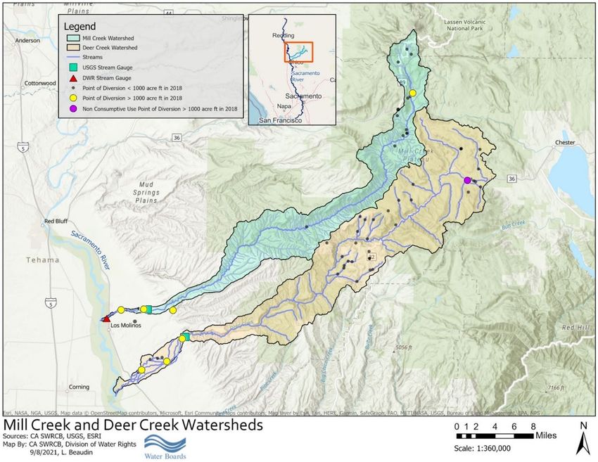
Data provided by CDFW (2021c); *Data obtained from CDFW (2017a).Figure 4: Mill and Deer Creek Watersheds
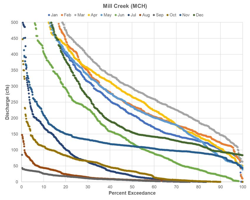
Watershed Descriptions
Figure 4 provides a map of the Mill and Deer Creek watersheds. Watershed
descriptions for Mill and Deer Creeks are also provided below.

Mill Creek – Watershed Description

The Mill Creek watershed is approximately 134 square miles, contains nearly 60 river
miles, and ranges in elevation from 8,000 feet in Lassen National Park to 200 feet at the
confluence with the Sacramento River. Mill Creek is one of three Sacramento River
tributaries to support a self-sustaining wild population of CV SR salmon; Mill Creek also
supports populations of fall-run Chinook salmon, and all life history stages of steelhead.
Mill Creek contains the highest elevation of CV SR salmon spawning activity in
California at approximately 5,300 feet, and the creek is one of the few undammed
streams in California where fish still have access to the upper stream reaches. Current
anadromous fish populations in the watershed are not influenced by the presence of
Federal, state, or private fish hatcheries. CV SR salmon and CCV steelhead critical
habitat was designated in 2005, which included habitat in Mill Creek (OFR, 2005).

Mill Creek is vulnerable to inadequate instream flows, particularly during drought years.
Adequate streamflow during salmonid migration periods will support the survival of adult
CV SR salmon and CCV steelhead by increasing critical passage riffle depth and
reducing water temperatures in Mill Creek.

Mill Creek is characterized as having a high potential to support a viable independent
population of CV SR salmon and CCV steelhead because of the extensive or suitable
spawning and rearing habitats (NMFS, 2014). Mill Creek is recognized as supporting
one of three remaining self‐sustaining independent CV SR salmon populations. Habitat
used for holding and spawning is located at high elevations and is considered to be high
quality (CDFG, 1998). Mill Creek is considered a conservation stronghold for the CV
SR salmon and has a high potential for sustaining a population at a low risk of extinction
with implementation of key recovery actions (NMFS 2014). Mill Creek contains holding
and spawning habitat to support a CV SR salmon population greater than 2,500, and
hatchery influence is low in Mill Creek (NMFS 2014). Lindley et al. (2007) classified the
Mill Creek CV SR salmon population as having a moderate risk of extinction; however,
in recent years, the abundance of the Mill Creek population has been in steep decline,
and the extinction risk may be trending toward moderate to high (NMFS 2014).

There are two major water diversion dams on Mill Creek, Upper Diversion Dam (river
mile (RM) 5.4) and Ward Diversion Dam (RM 2.8), both operated by LMMWC (Figure
4). There are two gauging stations collecting flow and water temperature data in lower
Mill Creek discussed in this digest. The U.S. Geological Survey (USGS) operates the
upstream gauge (USGS 11381500; CDEC Station ID: MLM for Mill Creek near Los
Molinos), which is located above both the major diversions at RM 5.8. The downstream
gauge (CDEC Station ID: MCH for Mill Creek below HWY 99) is operated by DWR and
is located below both major diversions at RM 0.8.
Upper Mill Creek, upstream of the Upper Diversion Dam, provides ideal cold water
holding pools and spawning habitat for CV SR salmon and CCV steelhead. However,
agricultural stream diversion in lower Mill Creek can result in insufficient stream flows
and elevated stream temperature which can limit the ability of adult salmon and
steelhead to migrate into the upper watershed. Inadequate flows also impede adult fall-
run and late fall-run Chinook salmon migration and impact outmigration of juvenile
Chinook salmon and steelhead (CDFW 2017a).
Based on an Electronic Water Rights Information Management System (eWRIMS)
database query, there are 22 active water right records within the Mill Creek watershed.
These water rights and claims reported a total annual diversion amount of
approximately 40,000 acre-feet in 2018. The Superior Court of Tehama County
adjudicated the water rights in Mill Creek in 1920. This decree apportions all flows in
Mill Creek up to 203 cfs and appoints LMMWC (Tehama County Superior Court Decree
#3811, 1920). Flow records show that diversions in lower Mill Creek have the potential
to entirely eliminate streamflow in June-September of a normal water year, and also at
other times of year in drought conditions.
Deer Creek – Watershed Description
Deer Creek also supports one of three remaining self-sustaining populations of
threatened CV SR salmon (Lindley et al., 2007), and is considered essential to the
recovery and perpetuation of wild stocks of CCV steelhead in the Central Valley
(Reynolds et al., 1993; McEwan and Jackson, 1996). Deer Creek originates near the
summit of Butt Mountain (7,320 feet elevation), flows in a southwesterly direction for
approximately 60 miles to the Sacramento River (180 feet elevation), and drains 229
square miles (NFMS, 2014; see Figure 1). Deer Creek contains approximately 42 miles
of anadromous fish habitat with approximately 25 miles of adult spawning and holding
habitat, most of which is located on public lands managed by Lassen National Forest.
While no major water storage facilities exist on Deer Creek, three diversion dams along
the lower 10 miles of the creek, as well as two natural falls, can be passage barriers to
migrating fish depending on flows. The Upper Deer Creek Falls constitutes the limit of
anadromy for CV SR salmon; however, Upper Deer Creek Falls fish ladder is
operational during the time steelhead would be migrating upstream in normal years
(NMFS, 2014; Amentrout et al., 1998). CV SR salmon and CCV steelhead critical
habitat was designated in 2005, which included habitat in Deer Creek (OFR, 2005).

There are three diversion dams in lower Deer Creek between the canyon mouth and the
Sacramento River confluence (NMFS 2014): Deer Creek Irrigation District (DCID)
Diversion Dam near the canyon mouth (RM 11.8); SVRIC Diversion Dam at RM 5.0,
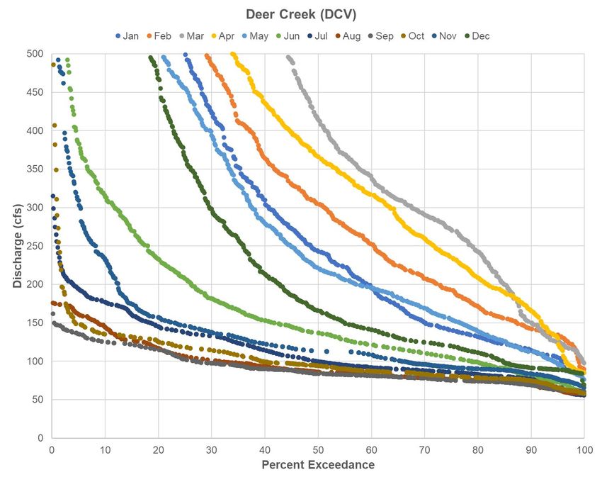
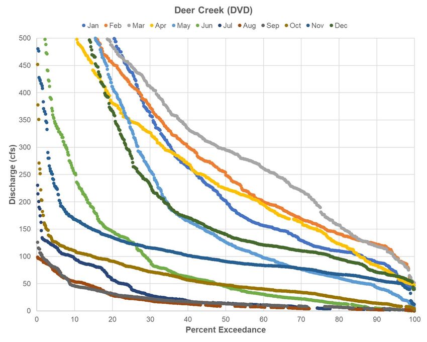
and the Cone-Kimball Diversion located on a side channel adjacent to RM 8.2 (Figure
4). Two gauging stations collect streamflow and water temperature data in Deer Creek.
The USGS operates the upstream gauging station (USGS 11383500; CDEC station ID:
DCV for Deer Creek near Vina), which is located at the mouth of the canyon at RM
12.3, above all major diversions and represents unimpaired flow for Deer Creek. DWR
operates the downstream gauging station (CDEC station ID: DVD for Deer Creek below
Stanford Vina Dam), which is located below all the diversions just below the SVRIC
Diversion Dam at RM 5.0.
Upper Deer Creek, upstream of the DCID diversion and the canyon mouth, provides
ideal cold water holding pools and spawning habitat for CV SR salmon and CCV
steelhead. However, agricultural stream diversions in lower Deer Creek can result in
insufficient stream flows and elevated stream temperature which can limit the ability of
adult salmon and steelhead to migrate into the upper watershed. Inadequate flows also
impede adult fall-run and late fall-run Chinook salmon migration and impact the
outmigration of juvenile Chinook salmon and steelhead (CDFW 2017b).
Based on an eWRIMS database query, there are 43 active water right records within the
Deer Creek watershed. These water rights and claims reported a total annual diversion
amount of approximately 32,000 acre-feet in 2018. The Tehama County Superior Court
adjudicated water rights on lower Deer Creek in 1923 by dividing 100% of Deer Creek’s
natural flows, with approximately 66% allocated to SVRIC, approximately 33% allocated
to DCID, and 1% to a third holder (Tehama County Superior Court Decree No. 4189,
1923). One study has assessed diversions as follows: during the irrigation period,
typically from May through October, DCID diverts an average of 29 cfs at the DCID
Dam, and the remaining flow can be diverted by SVRIC at Cone-Kimball Dam (5 cfs
average) and Stanford Vina Dam (70 cfs average), reducing flow in the lower five miles
of Deer Creek to less than 5 cfs at times of intensive irrigation (Tompkins and Kondolf,
2007). In critically dry years, these diversions and resulting low flows may occur earlier
in the year, especially if the irrigation season starts earlier.
Similarity of Watersheds
Deer Creek and Mill Creek are eastside tributaries to the Sacramento River (NMFS,
2014) (Figure 4). The watersheds are contiguously located within the southernmost
extension of the Cascade Range (Armentrout, 1998) and southwest of Lassen Peak.
The Tuscan formation, comprised primarily of mudflows with andesitic plugs, dominates
the geology of the watersheds (Guffanti et al., 1989). The Tuscan Formation is overlain
by voluminous flows of rhyolite which form Mill Creek and Lost Creek Plateaus in the
Mill Creek and Deer Creek watersheds. Marine sedimentary rocks have minor
exposures in the watersheds, and at lower elevations the creeks cut through quaternary
sediments from the Sacramento Valley. Soils generated in the watersheds are andesitic
soils and rhyolitic soils.
While the Mill Creek watershed has higher elevations than the Deer Creek watershed
(8,200 feet and 7,320 feet, respectively) both watersheds contain relatively undisturbed
habitat in their upper reaches. Both watersheds receive a portion of precipitation as
snow, with Mill Creek generally receiving the greatest amount of precipitation as snow
due to its higher elevations. Glacial processes have shaped some of the landforms at
the higher elevations of the watersheds. The upper portion of Mill Creek is a glacial
valley, and glacial deposits have been mapped at the headwaters of Deer Creek on Butt
Mountain (Lydon, 1968, as cited in Armentrout, 1998). Both watersheds are relatively
narrow and initially flow through meadows and dense forests before descending through
steep rock canyons into the Sacramento Valley (NMFS, 2009; Armentrout, 1998). The
geology and geomorphology of the Deer and Mill Creeks upper watersheds produce
exceptional fish habitat.

The lower reaches of both watersheds are made up of alluvial fan deposits with
evidence of stream meandering and multiple distributaries (TCRCD, 2010; Kondolf,
2001; CALFED, 2000). The lower watersheds contain alternating pools and riffles of
gravel sized sediment (TCRCD, 2010; Berens, 2002; Kondolf, 2001). Deer Creek’s and
Mill Creek’s upper alluvial reaches are able to meander but are bound by wide bluffs of
older cemented river gravels, typically 800 feet for Mill Creek and 1,000-2,000 feet for
Deer Creek. Downstream of the bluffs evidence of the multiple channels characteristic
of alluvial fans can be observed (Kondolf et al., 2001; CALFED, 2000). The 25,000 feet
alluvial reach of Mill Creek compares in sediment size and downstream change in
sediment size with the upper 25,000 feet of Deer Creek, measured from where it leaves
confined upper basin (Kondolf et al., 2001).

Mill Creek still has active distributaries; however, the North Fork Mill Creek distributary
is only active during high flows. Historical aerial photographs, taken in 1939, show the
lower portion of Deer Creek was sinuous, with small-scale bends, point bars, and
alternating pools and riffles (CALFED 2000). However, 16 kilometers of levees were
built along lower Deer Creek resulting in the straightening of channels, the abandoning
of natural distributaries and increased gravel flushing (Berens, 2002; MacWilliams et al.,
2004). The similar sedimentary and geomorphic characteristics of the lower watersheds
of Deer Creek and Mill Creek create comparable fish passage environments.

Runoff patterns for both watersheds are similar (NMFS, 2014; Armentrout, 1998). The
two watersheds have peak flows that are dominated by rain on snow events
(December- February) with later snowmelt peaks (mid-March-May) and low flows during
the summer. Mean June flows upstream of major diversions in the drought years of
1977, 2014, and 2015 in Deer and Mill Creeks ranged from 66-75 cfs and 98-106 cfs,
respectively. Deer Creek and Mill Creek watersheds typically produce over 200,000
acre-feet of water per year (Armentrout,1998; CDEC, 2021).
Upper reaches of both streams, upstream of major agricultural diversions, provide
excellent cold water holding pools and spawning habitat for salmonids (CDFW, 2017a,
2017b). However, agricultural stream diversions in lower reaches can result in
insufficient stream flows and elevated stream temperature which can limit the ability of
adult salmon and steelhead to migrate into the upper watershed. Inadequate flows also
impede adult fall-run and late fall-run Chinook salmon migration and impact
outmigration of juvenile Chinook salmon and steelhead (CDFW 2017a, 2017b).
Mill Creek and Deer Creek support multiple self-sustaining natural populations of
anadromous salmonids, including ESA-listed CV SR salmon and CCV steelhead. In
these tributary systems, adult CV SR salmon migration typically occurs from March
through July with a peak in migration during April through June, and CV SR salmon
juveniles are typically present from October through June, with a peak in out-migration
in January and February (NMFS, 2009). Adult CCV steelhead are typically present in
these tributary systems during February through June and October through December,
and juveniles can be present year-round (NMFS, 2009).

Mill Creek and Deer Creek share much of the same geology and geomorphology in their
upper watersheds, in addition to similar runoff patterns. The typical nature of the region
leads the State Water Board to conclude that studies and findings of flows and fish
habitat characteristics in one of the watersheds may be applied to the others.

Informative Digest

Summary of Existing Laws and Regulations
A general description of the following is set forth above: existing law governing water
rights; the water right priority system; and the constitutional prohibition against the
waste, unreasonable diversion, unreasonable method or diversion, or unreasonable use
of water.

Under existing law, the State Water Board may take enforcement action to prevent
unauthorized diversions of water or violations of the terms and conditions of water rights
permits and licenses. Diverting water when it is unavailable under a water right holder’s
priority of right constitutes an unauthorized diversion and a trespass against the state.
Violations are subject to an Administrative Civil Liability (ACL) under the Water Code.
(Wat. Code, § 1052.) Administrative cease and desist orders and court injunctions may
also be issued to require that diversions stop. (Wat. Code, § 1831.) An ACL order for an
unauthorized diversion may impose liability up to $1,000 a day plus $2,500 per acre foot
of water that is illegally diverted for violations during the current drought. The same
enforcement mechanisms exist for violations of permit and license terms and conditions
such as standard permit Term 91. For the State Water Board to take an enforcement
action, each illegal diversion may be investigated and charged separately, and water
You can also read