Forest Operations Inventory Vegetation - Oregon/Washington Bureau of Land Management Spatial Data Standard
←
→
Page content transcription
If your browser does not render page correctly, please read the page content below
Oregon/Washington Bureau of Land Management
Forest Operations Inventory Vegetation
Spatial Data Standard
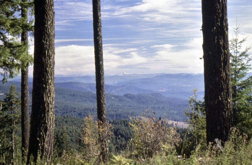
Vintage picture of Western Oregon forest stands. Photo by Don
Smurthwaite, BLM, October 1985.
Version 2.0 November 2021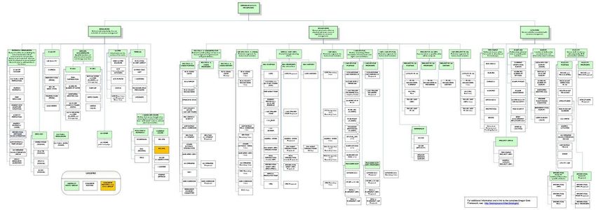
Bureau of Land Management                                                                         OR/WA State Data Standards

Document Revisions
 Revision           Date                   Author                       Description                          Affected Pages
 1.0                6/23/2015              Pam Keller, Dan Couch        Initial Release                      All
 1.1                03/10/17               Kyler Diershaw               Updated contact information for      Section 1.1, 2.5,
                                                                        State Data Steward, GIS              2.6, 4.0, Appendix
                                                                        Technical Lead, State Data           A
                                                                        Administrator, State Records         This page
                                                                        Administrator. Added
                                                                        Document Revision Table.
 1.2                03/13/2017             Kyler Diershaw               Added automatic TOC                  TOC
                                                                        Updated BLM_ORG_CD                   A.1
                                                                        Updated Records Retention            1.3
                                                                        Schedule
 1.3                10/18/2018             Al Thompson                  Reformat and rewrite                 All
 1.4                05/15/2019             Roger Mills                  Add domain for OI_DDD6
 1.5                02/19/2020             Roger Mills                  Add attributes for                   29, 32
                                                                        FOIVEG_PUB_POLY:
                                                                        STATE, TIMBER_TYPE,
                                                                        STOCK_CLASS.
 1.6                02/28/2020             Al Thompson                  Verify format updates.               All
 2.0                11/9/2021              Dana Baker-Allum,            Significant update with              All
                                           Carolina Hooper              reformatting, updated content to
                                                                        show related tables as part of the
                                                                        dataset, updated text to show that
                                                                        dataset has been expanded to all
                                                                        BLM states, and edits to text for
                                                                        clarity. Updated to make it more
                                                                        consistent with other data
                                                                        standards.
                                                                        Updated dom_MS_Veg_Source
                                                                        domain
 2.0                1/26/2022              Dana Baker-Allum             Added GLOBALID field.                Sections 4.1, 4.2,
                                                                                                             7.18
 2.0                2/23/2022              Dana Baker-Allum             Added OI_VEGRMKS to the              8.2.1
                                                                        FOIVEG Publication view.

Navigation
This document uses hyperlinks to display additional information on topics. External links are displayed with an underline.

Internal links are blue text, not underlined. After clicking on an internal link, press the Alt     + Left Arrow         keys to
return to the original location from the target location.

February 2022                              Forest Operations Inventory Vegetation                                                 2
Bureau of Land Management OR/WA State Data Standards
Contents
1 General Information ..................................................................................................................................... 8
1.1 Roles and Responsibilities .............................................................................................................. 8
1.2 FOIA Category ................................................................................................................................ 9
1.3 Records Retention Schedule ........................................................................................................... 9
1.4 Security/Access/Sensitivity ............................................................................................................. 9
1.5 Keywords ......................................................................................................................................... 9
1.6 Subject Function Codes .................................................................................................................. 9
2 Dataset Overview ........................................................................................................................................ 10
2.1 Usage .............................................................................................................................................. 10
2.2 Sponsor/Affected Parties .............................................................................................................. 10
2.3 Relationship to Other Datasets, Databases, or Files .................................................................. 10
2.4 Data Category/Architecture Link ................................................................................................ 10
2.5 Relationship to DOI Enterprise Architecture Data Resource Model ....................................... 14
3 Data Management Protocols ...................................................................................................................... 15
3.1 Accuracy Requirements ............................................................................................................... 15
3.2 Collection, Input, and Maintenance Protocols ........................................................................... 15
3.3 Update Frequency and Archival Protocols ................................................................................. 15
3.4 Statewide Monitoring ................................................................................................................... 15
4 FOIVEG Schema (simplified) .................................................................................................................... 17
4.1 Forest Vegetation Feature Dataset .............................................................................................. 17
4.1.1 FOIVEG_POLY Feature Class (Forest Operations Inventory Vegetation Polygons)
.......................................................................................................................................... 17
4.2 Forest Vegetation Related Tables ................................................................................................ 18
4.2.1 MS_LAYERS (Layers Table) ........................................................................................ 18
4.2.2 MS_LYR_SPP (Layer Species Table) ........................................................................... 18
4.2.3 MS_STAND (Stand Table) ............................................................................................ 19
4.2.4 MS_STD_SPP (Stand Species Table) ............................................................................ 20
4.2.5 MS_DOWNLOG (Down Log Table)............................................................................. 21
4.2.6 MS_DL_DECAY (Down Log Decay Table) ................................................................. 21
4.2.7 MS_SNAG (Snag Table) ................................................................................................ 22
4.2.8 MS_SG_DECAY (Snag Decay Table) ........................................................................... 22
5 Projection and Spatial Extent .................................................................................................................... 23
6 Spatial Entity Characteristics .................................................................................................................... 23
7 Attribute Characteristics and Definition (In alphabetical order) ........................................................... 24
7.1 ACCURACY_FT .......................................................................................................................... 24
7.2 BLM_ORG_CD ............................................................................................................................ 24
7.3 COORD_SRC................................................................................................................................ 25
February 2022 Forest Operations Inventory Vegetation 3Bureau of Land Management OR/WA State Data Standards
7.4 DDC_DC ........................................................................................................................................ 25
7.5 DDC_ID ......................................................................................................................................... 25
7.6 DDC_TCFPA ................................................................................................................................ 26
7.7 DDC_TCPPA ................................................................................................................................ 26
7.8 DDC_TLPA ................................................................................................................................... 26
7.9 DDC_TPPA ................................................................................................................................... 27
7.10 DDC_TTPA ................................................................................................................................... 27
7.11 DL_CLASSIFIER ......................................................................................................................... 27
7.12 DL_ID ............................................................................................................................................ 28
7.13 DL_MMD ...................................................................................................................................... 28
7.14 DL_MML ....................................................................................................................................... 29
7.15 DL_SRC ......................................................................................................................................... 29
7.16 DL_SRC_DT ................................................................................................................................. 29
7.17 GIS_ACRES .................................................................................................................................. 30
7.18 GLOBALID ................................................................................................................................... 30
7.19 LYR_BA ........................................................................................................................................ 31
7.20 LYR_BYR ..................................................................................................................................... 31
7.21 LYR_CC ........................................................................................................................................ 31
7.22 LYR_CLASSIFIER ...................................................................................................................... 32
7.23 LYR_HT ........................................................................................................................................ 32
7.24 LYR_ID ......................................................................................................................................... 32
7.25 LYR_LAYER ................................................................................................................................ 33
7.26 LYR_SRC ...................................................................................................................................... 33
7.27 LYR_SRC_DT .............................................................................................................................. 34
7.28 LYR_STKCLS .............................................................................................................................. 34
7.29 LYR_TPA ...................................................................................................................................... 34
7.30 OI_AGECLS_10 ........................................................................................................................... 35
7.31 OI_AGECLS_10_DT .................................................................................................................... 35
7.32 OI_DD1 .......................................................................................................................................... 35
7.33 OI_DD2 .......................................................................................................................................... 36
7.34 OI_DD3 .......................................................................................................................................... 36
7.35 OI_DD4 .......................................................................................................................................... 36
7.36 OI_DD5 .......................................................................................................................................... 37
7.37 OI_DD6 .......................................................................................................................................... 37
7.38 OI_KEY ......................................................................................................................................... 37
7.39 OI_STAND_DESC ........................................................................................................................ 38
7.40 OI_TRS .......................................................................................................................................... 38
7.41 OI_UNITNO .................................................................................................................................. 39
February 2022 Forest Operations Inventory Vegetation 4Bureau of Land Management OR/WA State Data Standards
7.42 OI_VEGRMKS ............................................................................................................................. 39
7.43 SA_AGECLS_LYR ...................................................................................................................... 39
7.44 SA_BA ............................................................................................................................................ 40
7.45 SA_BA7 .......................................................................................................................................... 40
7.46 SA_CLASSIFIER ......................................................................................................................... 40
7.47 SA_CNPYCOVR .......................................................................................................................... 41
7.48 SA_COVRTYPE ........................................................................................................................... 41
7.49 SA_CURTIS_RD .......................................................................................................................... 42
7.50 SA_CURTIS_RD7 ........................................................................................................................ 42
7.51 SA_ID ............................................................................................................................................. 42
7.52 SA_MBF_AC ................................................................................................................................. 43
7.53 SA_PAG ......................................................................................................................................... 43
7.54 SA_PAG_SRC ............................................................................................................................... 44
7.55 SA_QMD ....................................................................................................................................... 44
7.56 SA_QMD7 ..................................................................................................................................... 44
7.57 SA_RDI .......................................................................................................................................... 45
7.58 SA_RMKS ..................................................................................................................................... 45
7.59 SA_SCLS100 ................................................................................................................................. 46
7.60 SA_SCLS50 ................................................................................................................................... 46
7.61 SA_SDI........................................................................................................................................... 46
7.62 SA_SIM100 .................................................................................................................................... 47
7.63 SA_SIM50 ...................................................................................................................................... 47
7.64 SA_SIT100 ..................................................................................................................................... 47
7.65 SA_SIT50 ....................................................................................................................................... 48
7.66 SA_SITECLS_SRC ...................................................................................................................... 48
7.67 SA_SITECLS_SRC_DT ............................................................................................................... 48
7.68 SA_SNDX100 ................................................................................................................................ 49
7.69 SA_SNDX50 .................................................................................................................................. 49
7.70 SA_STAND_SRC .......................................................................................................................... 50
7.71 SA_STAND_SRC_DT .................................................................................................................. 50
7.72 SA_STAND_STRUC .................................................................................................................... 50
7.73 SA_TPA7 ....................................................................................................................................... 51
7.74 SA_TTPA ....................................................................................................................................... 51
7.75 SASP_BA ....................................................................................................................................... 51
7.76 SASP_BA7 ..................................................................................................................................... 52
7.77 SASP_BFVPA ............................................................................................................................... 52
7.78 SASP_ID ........................................................................................................................................ 53
7.79 SASP_SP ........................................................................................................................................ 53
February 2022 Forest Operations Inventory Vegetation 5Bureau of Land Management OR/WA State Data Standards
7.80 SASP_TPA ..................................................................................................................................... 53
7.81 SASP_TPA7 ................................................................................................................................... 54
7.82 SDC_DC......................................................................................................................................... 54
7.83 SDC_ID .......................................................................................................................................... 54
7.84 SDC_TSPA .................................................................................................................................... 55
7.85 SG_CLASSIFIER ......................................................................................................................... 55
7.86 SG_ID............................................................................................................................................. 55
7.87 SG_MMDBH ................................................................................................................................. 56
7.88 SG_MMHT .................................................................................................................................... 56
7.89 SG_SRC ......................................................................................................................................... 56
7.90 SG_SRC_DT.................................................................................................................................. 57
7.91 SL_DBH_SC .................................................................................................................................. 57
7.92 SL_ID ............................................................................................................................................. 57
7.93 SL_MAJ_MIN ............................................................................................................................... 58
7.94 SL_SP_CR ..................................................................................................................................... 58
7.95 SL_SP_PCT ................................................................................................................................... 59
7.96 SL_SPECIES ................................................................................................................................. 59
7.97 SL_US_PCT .................................................................................................................................. 59
7.98 SL_US_SP_HT .............................................................................................................................. 60
7.99 VERSION_NAME ........................................................................................................................ 60
8 Publication Views ........................................................................................................................................ 61
8.1 General........................................................................................................................................... 61
8.2 Specific to This Dataset ................................................................................................................ 61
8.2.1 FOIVEG_PUB_POLY ................................................................................................... 61
8.2.2 MS_LAYERS_PUB ........................................................................................................ 63
8.2.3 MS_LYR_SPP_PUB ....................................................................................................... 63
8.2.4 MS_STAND_PUB ........................................................................................................... 63
8.2.5 MS_STD_SPP_PUB ....................................................................................................... 63
8.2.6 MS_DOWNLOG_PUB .................................................................................................. 64
8.2.7 MS_DL_DECAY_PUB .................................................................................................. 64
8.2.8 MS_SNAG_PUB ............................................................................................................. 64
8.2.9 MS_SG_DECAY_PUB ................................................................................................... 64
9 Editing Procedures ...................................................................................................................................... 65
9.1 Managing Overlap ........................................................................................................................ 65
9.2 Editing Quality Control ................................................................................................................ 65
9.3 Vertical Integration ...................................................................................................................... 66
9.4 Theme Specific Guidance ............................................................................................................. 66
9.4.1 General Guidance for Spatial and Attribute Changes ................................................ 66
February 2022 Forest Operations Inventory Vegetation 6Bureau of Land Management OR/WA State Data Standards
9.4.2 Factors to Guide Spatial and Attribute Edits ............................................................... 66
9.4.3 GIS Reference Layers .................................................................................................... 67
9.4.4 Data Quality Checks ....................................................................................................... 67
10 Abbreviations and Acronyms ..................................................................................................................... 69
11 References .................................................................................................................................................... 70
A Domains (Valid Values) .............................................................................................................................. 71
A.1 dom_BLM_ORG_CD ................................................................................................................... 71
A.2 dom_COORD_SRC ...................................................................................................................... 71
A.3 dom_MS_Layer_DBH_SC ........................................................................................................... 72
A.4 dom_MS_DecayClass ................................................................................................................... 72
A.5 dom_MS_Layer ............................................................................................................................. 72
A.6 dom_MS_Layer_Species_All ....................................................................................................... 72
A.7 dom_MS_Layer_Species_Trees ................................................................................................... 73
A.8 dom_MS_Layer_Species_Understory ......................................................................................... 73
A.9 dom_MS_Layer_StockClass ........................................................................................................ 73
A.10 dom_MS_SA_AgeCls_Lyr ........................................................................................................... 73
A.11 dom_MS_SA_CovrType............................................................................................................... 74
A.12 dom_MS_SA_PAG ....................................................................................................................... 74
A.13 dom_MS_SA_PAG_SRC ............................................................................................................. 74
A.14 dom_MS_SA_SIT100 ................................................................................................................... 76
A.15 dom_MS_SA_SIT50 ..................................................................................................................... 76
A.16 dom_MS_SA_SiteClass ................................................................................................................ 77
A.17 dom_MS_SA_SS ........................................................................................................................... 77
A.18 dom_MS_TrueFalse ...................................................................................................................... 77
A.19 dom_MS_Veg_Source................................................................................................................... 77
B FOIVEG Data Structure Relationships..................................................................................................... 79
C Snag Decay Class Diagram ......................................................................................................................... 80
D Down Log Decay Class Diagram ................................................................................................................ 81
February 2022 Forest Operations Inventory Vegetation 7Bureau of Land Management OR/WA State Data Standards
1 General Information
The Forest Operations Inventory Vegetation (FOIVEG_POLY) feature class is a forest-centric classification of
vegetation with polygons that cover 100% of western Oregon BLM lands and some BLM managed areas in the rest
of the United States. It describes forested lands in detail and non-forest lands with broad and general
classifications. It includes and uses related table data from the Micro*Storms (M*S) system to describe forest
vegetation. Polygons are delineated primarily based on differences in vegetative cover, size, and age.
FOIVEG_POLY attributes describe both the overall forest stand as well as the layers within that stand. Cover type
and ten-year age class are part of the description of the overall forest stand. The stand description, which includes
species, size class, and birth year, describes the stand but, also, the layers of forest canopies within each stand.
M*S provides the tool to edit FOIVEG_POLY attributes and provides additional vegetation information that could
be used in conjunction with FOIVEG_POLY. M*S provides related tables of stand attributes, such as site class
and site index, along with summary stand metrics data commonly resulting from stand exam surveys.
• Dataset (Theme) Name: Forest Vegetation
• Dataset (Feature Class): FOIVEG_POLY, MS_LAYERS, MS_LYR_SPP, MS_STAND,
MS_STAND_SPP, MS_SNAG, MS_SG_DECAY, MS_DOWNLOG, MS_DL_DECAY
1.1 Roles and Responsibilities
Table 1 Roles and Responsibilities
Roles Responsibilities
State Data Steward The State Data Steward responsibilities include approving data standards and
business rules, developing Quality Assurance/Quality Control procedures,
identifying potential Privacy issues, and managing that data as a corporate
resource. The State Data Steward coordinates with district data stewards, the
State Data Administrator, Geographic Information System (GIS) coordinators,
and national data stewards. The State Data Steward reviews geospatial metadata
for completeness and quality.
GIS Technical Lead The GIS Technical Lead works with data stewards to convert business needs into
GIS applications and derive data requirements and participates in the
development of data standards. The GIS technical lead coordinates with system
administrators and GIS coordinators to manage the GIS databases. The GIS
technical lead works with data editors to ensure the consistency and accordance
with the established data standards of data input into the enterprise Spatial
Database Engine (SDE) geodatabase. The GIS technical lead provides technical
assistance and advice on GIS analysis, query, and display of the dataset.
State Data Administrator The State Data Administrator provides information management leadership, data
modeling expertise, and custodianship of the state data models. The State Data
Administrator ensures compliance with defined processes for development of
data standards and metadata, and process consistency and completeness. The
State Data Administrator is responsible for making data standards and metadata
accessible to all users. The State Data Administrator coordinates with data
stewards and GIS coordinators to respond to national spatial data requests.
State Records The State Records Administrator assists the state data steward to identify any
Administrator privacy issues related to spatial data. The state records administrator also
provides direction and guidance on data release and fees. The state records
administrator classifies data under the proper records retention schedule and
February 2022 Forest Operations Inventory Vegetation 8Bureau of Land Management OR/WA State Data Standards
determines the appropriate Freedom of Information Act category.
1.2 FOIA Category
This dataset falls under the standard Records Access Category 1(B) – BLM records that may contain protected
information that must be considered for segregation prior to release. See section 8 for more information on which
data are available to the public.
1.3 Records Retention Schedule
The DRS/GRS/BLM Combined Records Schedule, under Schedule 20/52a4 (Electronic Records/Geographic
Information Systems), lists this theme (Vegetation Treatment and Management) as one of the system-centric
themes that are significant for BLM’s mission that must be permanently retained.
"PERMANENT. Cutoff at the end of each Fiscal Year (FY) or when significant changes and additions have been
made, before and after the change. Use BLM 20/52a. Transfer to the National Archives every three years after
cutoff. Under the instruction in 36 CFR 1235.44-50 or whichever guidance is in place at the time of the transfer.
Submissions are full datasets and are in addition to, not replacements of, earlier submissions."
Oregon/Washington (OR/WA) Bureau of Land Management (BLM) Guidebook for Management of Geospatial
Data (v1) Section 15.2 - Corporate Data Online Archives prescribes:
"Vector annual archives are retained online for 12 years. Each year, data that has reached 12 years old is copied
off-line to be retained until no longer needed (determined by data stewards and program leads) with format and
readability maintained in a five (5) year "tech refresh" update cycle."
1.4 Security/Access/Sensitivity
The Forest Operations Inventory Vegetation theme does not require any additional security other than that provided
by the General Support System (the hardware/software infrastructure of the OR/WA BLM).
This dataset is not sensitive and there are no restrictions on access to this data within the BLM or external to the
BLM. This dataset falls under the standard Records Access Category 1(B) – BLM records that may contain
protected information that must be considered for segregation prior to release. All classifier and comments fields
should be removed from external datasets.
There are no privacy issues or concerns associated with these data themes. A privacy impact assessment was
submitted for this dataset on May 1, 2015. The Privacy Impact Assessment (PIA) number is 105e3720RS.
1.5 Keywords
Keywords that can be used to locate this dataset include:
• BLM Thesaurus: Forest, Vegetation
• Additional keywords: Forestry, Trees, Forest Operations Inventory, FOI, Timber Stand, Land Use
Planning, Forest Regeneration, Forest Restocking, Forest Cover, Natural Resources
• ISO Thesaurus: biota
1.6 Subject Function Codes
BLM Subject Function codes used to describe this dataset include:
February 2022 Forest Operations Inventory Vegetation 9Bureau of Land Management OR/WA State Data Standards
• 1283 - Data Administration
• 1610 - Resource Management Planning
• 5000 - Forest Management
• 9167 - Geographic Information System (GIS)
2 Dataset Overview
2.1 Usage
This dataset is the spatial corporate repository for forest vegetation on BLM lands. It is used as a comprehensive
record of vegetation on public lands at the unit level or at the broad landscape level using stand type or age class
distribution. The published version of this dataset contains stand summary data and stand metrics that describe the
vegetation in more detail. This data comes from stand exam and field surveys, photo interpretation, and remote
sensing data.
2.2 Sponsor/Affected Parties
The sponsor for this data set is the Deputy State Director for the Division of Resources, Lands, Mineral and Fire.
Forest Vegetation is defined by and specific to the BLM and occurs on BLM Lands. No interagency data standard
exists for the current version of Forest Operations Inventory Vegetation.
2.3 Relationship to Other Datasets, Databases, or Files
Forest Operations Inventory Vegetation is related to the following datasets:
• Treatments - Treatment feature classes provide a history of vegetation treatments in the current vegetation
description in FOIVEG_POLY and vegetation treatments that are proposed to occur on operational units.
The Treatment Local Link attribute contains the OI Key Number from FOIVEG_POLY.
• Reforestation and Forest Surveys - This dataset describes surveys associated with the vegetation of an
Operations Inventory unit. It provides a list of completed and proposed surveys that help to describe the
current vegetation of FOIVEG_POLY. It also provides the spatial location of stand exam surveys that
provide the stand metrics in the M*S dataset. The Forest Survey Local Link attribute contains the OI Key
Number from FOIVEG_POLY.
• EcoSurvey Database - The EcoSurvey dataset contains tree and vegetation data collected on a point-by-
point basis during stand exam surveys. The EcoSurvey program can summarize and export, in an
automated process, the stand attributes to the M*S related tables and update the Stand Description and
Ten-Year Age Class of FOIVEG_POLY. This process uses the OI Key number from FOIVEG_POLY to
link with data having the same OI number in the EcoSurvey database.
• Other GIS reference layers are frequently used to define FOIVEG polygons. These include: CADNSDI
representing the public land survey system (PLSS) and land line (LLI) data for ownership, LiDAR, GTRN
Transportation, Hydrography, and topography.
2.4 Data Category/Architecture Link
This data theme is a portion of the Oregon Data Framework (ODF) shown in Figure 1, Oregon Data Framework
(ODF) Overview on page 9. The illustration is a simplified schematic of the entire ODF showing the overall
February 2022 Forest Operations Inventory Vegetation 10Bureau of Land Management OR/WA State Data Standards
organization and entity inheritance. The ODF utilizes the concept of inheritance to define specific instances of
data. The ODF divides all OR/WA resource-related data into three general categories:
• Activities
• Resources
• Boundaries
These general categories are broken into sub-categories that inherit spatial characteristics and attributes from their
parent category. These sub-categories may be further broken into more specific groups until the basic data set
cannot be further sub-divided. Those basic data sets inherit all characteristics of all groups/categories above them.
The basic data sets are where physical data gets populated. Those groups/categories above them do not contain
actual data but set parameters which all data of that type must follow.
February 2022 Forest Operations Inventory Vegetation 11Bureau of Land Management OR/WA State Data Standards
Figure 1 Oregon Data Framework Overview
February 2022 Forest Operations Inventory Vegetation 12Bureau of Land Management OR/WA State Data Standards
Physical data is populated in the basic data sets. Those groups/categories above them do not contain actual data but
set parameters that all data of that type must follow. See Figure 2, Data Organization Structure for a simplified
schematic of the entire ODF showing the overall organization and entity inheritance. The FOIVEG entities are
highlighted. For additional information about the ODF, contact the State Data Administrator. The State Data
Administrator’s contact information can be found at the following link:
https://www.blm.gov/about/data/oregon-data-management
In the ODF, FOIVEG is considered a natural resource and categorized as follows:
ODF
Resources
Landscape Cover
Current Cover
FOIVEG_POLY
Figure 2 Data Organization Structure
February 2022 Forest Operations Inventory Vegetation 13Bureau of Land Management OR/WA State Data Standards
2.5 Relationship to DOI Enterprise Architecture Data Resource Model
The Department of the Interior (DOI) Enterprise Architecture contains a component called the Data Resource
Model. This model addresses the concepts of data sharing, data description, and data context. This data standard
provides information needed to address each of those areas. Data sharing is addressed through complete
documentation and simple data structures which make sharing easier. Data description is addressed through the
section on Attribute Descriptions. Data context is addressed through the data organization and structure portions of
this document. In addition, the DOI Data Resource Model categorizes data by use of standardized Data Subject
Areas and Information Classes. For this data set, the Data Subject Area and Information Class are:
• Data Subject Area: Geospatial
• Information Class: Location
February 2022 Forest Operations Inventory Vegetation 14Bureau of Land Management OR/WA State Data Standards
3 Data Management Protocols
3.1 Accuracy Requirements
This dataset has a wide range of accuracies. Locational accuracy is dependent on the original classifier, or the base
map used to generate the vegetation polygon, but there are many instances where this source is unknown because
this polygon dataset has been managed by a variety of methods which predate the implementation of GIS. Many
features were imported from the legacy data. However, more recent polygons generated in association with timber
sales or updated imagery have a higher level of spatial accuracy and will have more complete information. Over
time the dataset will become more accurate. A high degree of accuracy is not required for forest vegetation and, in
some cases; the process of classifying vegetation does not lend itself to precise boundaries.
3.2 Collection, Input, and Maintenance Protocols
The primary reasons for creation of new polygons are significant changes in vegetation species composition, size,
and density observed on aerial photography or other remote sensing data.. The target minimum mapping size for
vegetation types is five acres. Map unique features such as ponds and rock outcrops detectable on resource
photography down to as small as one acre. Similarly, timber harvest, silviculture treatments, or other disturbances
which are one acre or larger that result in significant change in vegetation may also be defined as unique
FOIVEG_POLY polygons.
Overlapping or multi-part polygons are not allowed. Adjust the boundaries of the surrounding polygons when
creating a new vegetation polygon, so that this does not occur. In the past, FOIVEG_POLY polygons needed to be
mapped to match BLM administered land boundaries, township, range and section line delineations, county
boundaries, and Resource Area boundaries. However, except for staying within BLM administered lands and
within district boundaries, the FOIVEG_POLY polygons can cross over these administrative lines to describe the
continuity of a forest stand.
Detailed editing guidance is available in section 9 of this document.
3.3 Update Frequency and Archival Protocols
The State Data Steward and/or the Program Lead establish the policy for update frequency and completeness for
the FOIVEG_POLY data. They base updates on disturbances or treatments that change the vegetation type or age
class, such as fire or harvest. District resource specialists work with GIS specialists to map spatial extents of the
forest vegetation. The theme is checked for spatial and attribute accuracy as data is input. Additions might be
monthly or quarterly but, at least, annually. District specialists need to ensure that data in the FOIVEG_POLY
theme are complimentary with associated records in the EcoSurvey application. Additional guidance is available in
IB-OR-2019-004.
Data is archived annually at the end of the fiscal year.
3.4 Statewide Monitoring
The State Data Steward, assisted by the GIS Technical Lead, are responsible for checking consistency across
districts for the theme. The State Data Steward is responsible for coordinating the response to national BLM and
interagency data calls.
Each year, the Resource Science Data team of the BLM Division of Resources, Lands, Minerals and Fire meets
with each state data steward for every corporate geospatial theme to conduct an annual review of the data. During
the annual review, geospatial staff present the state data stewards with a report detailing Quality Assurance/Quality
February 2022 Forest Operations Inventory Vegetation 15Bureau of Land Management OR/WA State Data Standards
Control (QAQC) results performed on the data. The QAQC does the following:
• Checks that all attribute values conform to the range or coded-value domains to which they are applied.
• Checks that all attributes marked as required in the data standard have values.
• Checks for duplicate features which have the same geometry and attributes.
• Checks for overlapping features if forbidden by the data standard.
• Checks for invalid geometry.
• Other checks as necessary (can be customized according to the data standard).
In addition to this report, geospatial staff conduct a qualitative needs assessment with the steward to identify any
unmet needs or problems with the status of the data. At the conclusion of the review, the team records the
steward's approvals of the datasets reviewed. These approvals are then added to the corporate metadata.
February 2022 Forest Operations Inventory Vegetation 16Bureau of Land Management OR/WA State Data Standards
4 FOIVEG Schema (simplified)
General Information: Attributes are listed in the order they appear in the geodatabase feature class. The order is an
indication of the importance of the attribute for theme definition and use. There are no aliases unless specifically
noted. The domains used in this data standard can be found in Appendix A. These are the domains at the time the
data standard was approved. Domains can be changed without a re-issue of the data standard. Current domains are
found on the internal OR/WA SharePoint data management page. Some of the domains used in this data standard
are also available at the following web site: https://www.blm.gov/about/data/oregon-data-management
For domains not listed at that site contact: State Data Administrator.
4.1 Forest Vegetation Feature Dataset
4.1.1 FOIVEG_POLY Feature Class (Forest Operations Inventory Vegetation
Polygons)
For domain and default values, see Section 7 Attribute Characteristics and Definition (In alphabetical order) in this
document.
Attribute Name Data Type Length Default Value Required Domain
BLM_ORG_CD String 5 Yes * dom_BLM_ORG_CD
OI_KEY Long Integer Yes *
OI_STAND_DESC String 255 UNKNOWN Yes
OI_AGECLS_10 Double No
OI_AGECLS_10_DT String 8 No
GIS_ACRES Double Yes *
OI_TRS String 25 No *
OI_UNITNO String 3 No
OI_DD1 String 255 No
OI_DD2 String 255 No
OI_DD3 String 255 No
OI_DD4 Double No
OI_DD5 Double No
OI_DD6 Double No
COORD_SRC String 7 No dom_COORD_SRC
ACCURACY_FT Short Integer No
VERSION_NAME String 50 InitialLoad Yes *
OI_VEGRMKS String 2000 No
GLOBALID GUID Yes *
* Values automatically generated
** Enforced during quality control, may appear in data as not required
*** Maintained through versioning tools, may appear not required in database
February 2022 Forest Operations Inventory Vegetation 17Bureau of Land Management OR/WA State Data Standards
4.2 Forest Vegetation Related Tables
4.2.1 MS_LAYERS (Layers Table)
For domain and default values, see Section 7 Attribute Characteristics and Definition (In alphabetical order) in this
document.
Attribute Name Data Type Length Default Value Required Domain
LYR_ID Long Integer Yes *
OI_KEY String 40 Yes *
LYR_CLASSIFIER String 30 Yes
LYR_SRC String 25 Yes dom_MS_Veg_Source
LYR_SRC_DT String 8 Yes
LYR_LAYER String 40 Yes dom_MS_Layer
LYR_CC Double No
LYR_HT Long Integer No
LYR_TPA Long Integer No
LYR_BA Double No
LYR_STKCLS String 20 Conditional dom_MS_Layer_StockClass
LYR_BYR Long Integer Conditional
VERSION_NAME String 50 InitialLoad Yes *
GLOBALID GUID Yes *
* Values automatically generated
** Enforced during quality control, may appear in data as not required
*** Maintained through versioning tools, may appear not required in database
4.2.2 MS_LYR_SPP (Layer Species Table)
For domain and default values, see Section 7 Attribute Characteristics and Definition (In alphabetical order) in this
document.
Attribute Name Data Type Length Default Required Domain
Value
SL_ID String 40 Yes *
LYR_ID String 40 Yes *
SL_MAJ_MIN String 1 No dom_MS_TrueFalse
SL_SPECIES Long Yes dom_MS_Layer_Species_All,
Integer dom_MS_Layer_Species_Trees,
dom_MS_Layer_Species_Understory
SL_SP_PCT Double Conditional
SL_DBH_SC Long Conditional dom_MS_Layer_DBH_SC
Integer
SL_SP_CR Double No
February 2022 Forest Operations Inventory Vegetation 18Bureau of Land Management OR/WA State Data Standards
Attribute Name Data Type Length Default Required Domain
Value
SL_US_SP_HT Double No
SL_US_PCT Double No
VERSION_NAME String 50 InitialLoad Yes *
GLOBALID GUID Yes *
* Values automatically generated
** Enforced during quality control, may appear in data as not required
*** Maintained through versioning tools, may appear not required in database
4.2.3 MS_STAND (Stand Table)
For domain and default values, see Section 7 Attribute Characteristics and Definition (In alphabetical order) in this
document.
Attribute Name Data Type Length Default Value Required Domain
SA_ID String 40 Yes *
OI_KEY Long Integer Yes *
SA_COVRTYPE String 3 Yes dom_MS_SA_CovrType
SA_STAND_SRC String 7 Yes dom_MS_SA_SS
SA_AGECLS_LYR String 10 Yes dom_MS_SA_AgeCls_Lyr
SA_TTPA Long Integer No
SA_QMD Double No
SA_BA Long Integer No
SA_CURTIS_RD Double No
SA_SDI Long Integer No
SA_RDI Double No
SA_CNPYCOVR Double No
SA_TPA7 Long Integer No
SA_QMD7 Double No
SA_BA7 Long Integer No
SA_CURTIS_RD7 Double No
SA_MBF_AC Double No
SA_CLASSIFIER String 30 Yes
SA_STAND_SRC String 25 Yes dom_MS_Veg_Source
SA_STAND_SRC_DT String 8 Yes
SA_SIM100 String 1 No dom_MS_TrueFalse
SA_SIT100 String 30 No dom_MS_SA_SIT100
SA_SNDX100 Short Integer No
February 2022 Forest Operations Inventory Vegetation 19Bureau of Land Management OR/WA State Data Standards
Attribute Name Data Type Length Default Value Required Domain
SA_SCLS100 Short Integer No dom_MS_SA_SiteClass
SA_SIM50 String 1 No dom_MS_TrueFalse
SA_SIT50 String 30 No dom_MS_SA_SIT50
SA_SNDX50 Short Integer No
SA_SCLS50 Short Integer No dom_MS_SA_SiteClass
SA_SITECLS_SRC String 25 Conditional dom_MS_Veg_Source
SA_SITECLS_SRC_DT String 8 Conditional
SA_PAG String 10 No dom_MS_SA_PAG
SA_PAG_SRC String 3 No dom_MS_SA_PAG_SRC
VERSION_NAME String 50 InitialLoad Yes *
SA_RMKS String 2000 No
GLOBALID GUID Yes *
* Values automatically generated
** Enforced during quality control, may appear in data as not required
*** Maintained through versioning tools, may appear not required in database
4.2.4 MS_STD_SPP (Stand Species Table)
For domain and default values, see Section 7 Attribute Characteristics and Definition (In alphabetical order) in this
document.
Attribute Name Data Type Length Default Value Required Domain
SASP_ID String 40 Yes *
SA_ID String 40 Yes *
SASP_SP Long Integer No dom_MS_Layer_Species_Trees
SASP_TPA Long Integer No
SASP_TPA7 Long Integer No
SASP_BA Long Integer No
SASP_BA7 Long Integer No
SASP_BFVPA Long Integer No
VERSION_NAME String 50 InitialLoad Yes *
GLOBALID GUID Yes *
* Values automatically generated
** Enforced during quality control, may appear in data as not required
*** Maintained through versioning tools, may appear not required in database
February 2022 Forest Operations Inventory Vegetation 20Bureau of Land Management OR/WA State Data Standards
4.2.5 MS_DOWNLOG (Down Log Table)
For domain and default values, see Section 7 Attribute Characteristics and Definition (In alphabetical order) in this
document.
Attribute Name Data Type Length Default Value Required Domain
DL_ID String 40 Yes *
OI_KEY Long Integer Yes *
DL_CLASSIFIER String 30 Yes
DL_SRC String 25 Yes dom_MS_Veg_Source
DL_SRC_DT String 8 Yes
DL_MMD Long Integer Yes
DL_MML Long Integer Yes
VERSION_NAME String 50 InitialLoad Yes *
GLOBALID GUID Yes *
* Values automatically generated
** Enforced during quality control, may appear in data as not required
*** Maintained through versioning tools, may appear not required in database
4.2.6 MS_DL_DECAY (Down Log Decay Table)
For domain and default values, see Section 7 Attribute Characteristics and Definition (In alphabetical order) in this
document.
Attribute Name Data Type Length Default Value Required Domain
DDC_ID String 40 Yes *
DL_ID String 40 Yes *
DDC_DC Long Integer Yes dom_MS_DecayClass
DDC_TTPA Long Integer No
DDC_TCFPA Long Integer No
DDC_TCPPA Double No
DDC_TPPA Long Integer No
DDC_TLPA Long Integer No
VERSION_NAME String 50 InitialLoad Yes *
GLOBALID GUID Yes *
* Values automatically generated
** Enforced during quality control, may appear in data as not required
*** Maintained through versioning tools, may appear not required in database
February 2022 Forest Operations Inventory Vegetation 21Bureau of Land Management OR/WA State Data Standards
4.2.7 MS_SNAG (Snag Table)
For domain and default values, see Section 7 Attribute Characteristics and Definition (In alphabetical order) in this
document.
Attribute Name Data Type Length Default Value Required Domain
SG_ID String 40 Yes *
OI_KEY Long Integer Yes *
SG_CLASSIFIER String 30 Yes
SG_SRC String 25 Yes dom_MS_Veg_Source
SG_SRC_DT String 8 Yes
SG_MMDBH Long Integer Yes
SG_MMHT Long Integer Yes
VERSION_NAME String 50 InitialLoad Yes *
GLOBALID GUID Yes *
* Values automatically generated
** Enforced during quality control, may appear in data as not required
*** Maintained through versioning tools, may appear not required in database
4.2.8 MS_SG_DECAY (Snag Decay Table)
For domain and default values, see Section 7 Attribute Characteristics and Definition (In alphabetical order) in this
document.
Attribute Name Data Type Length Default Value Required Domain
SDC_ID String 40 Yes *
SG_ID String 40 Yes *
SDC_DC String 10 Yes dom_MS_DecayClass
SDC_TSPA Double Yes
VERSION_NAME String 50 InitialLoad Yes *
GLOBALID GUID Yes *
* Values automatically generated
** Enforced during quality control, may appear in data as not required
*** Maintained through versioning tools, may appear not required in database
February 2022 Forest Operations Inventory Vegetation 22You can also read