Freeways Without 2021 - Congress for the ...
←
→
Page content transcription
If your browser does not render page correctly, please read the page content below
Freeways
Without
Futures
2021

          FREEWAYS WITHOUT FUTURES 2021 / 1
Table of Contents
    P4 / Introduction
    P8 / Freeways Without Futures
       P10 / Brooklyn-Queens Expressway, New York, New York
       P12 / Claiborne Expressway (I-10), New Orleans, Louisiana
       P14 / Inner Loop North, Rochester, New York
       P16 / I-244, Tulsa, Oklahoma
       P18 / I-275, Tampa, Florida
       P20 / I-345, Dallas, Texas
       P22 / I-35, Austin, Texas
       P24 / I-35, Duluth, Minnesota
       P26 / I-5, Seattle, Washington
       P28 / I-81, Syracuse, New York
       P30 / I-980, Oakland, California
       P32 / Kensington Expressway, Buffalo, New York
       P34 / North Loop (I-35/70), Kansas City, Missouri
       P36 / Scajaquada Expressway, Buffalo, New York
       P38 / The Great Highway, San Francisco, California

    P40 / Graduated Campaigns
    P42 / Conclusion
    P46 / Further Reading

2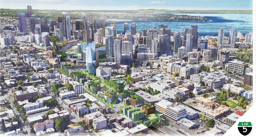
Acknowledgments
The primary author of this document is        Cover photo: New development along
Ben Crowther, Program Manager at the          Rochester, New York’s former Inner Loop
Congress for the New Urbanism. Lynn           (the right-of-way of the former highway
Richards, President and CEO at the            is now the grass lots to the right of Union
Congress for the New Urbanism, Margaret       Street). Credit: Stantec
O’Neal, Deputy Director at the Congress for
the New Urbanism, Rob Steuteville, Senior
Communications Advisor at the Congress
for the New Urbanism, and Lauren Mayer,
Communications Associate at the Congress
for the New Urbanism provided extensive
editorial support.

Selections for this report were made by a
national advisory committee consisting of:

Nana-Yaw Andoh, Ph.D. candidate,
Taubman College of Architecture and
Planning, University of Michigan

Norman Garrick, Professor of Civil
Engineering, University of Connecticut

Elizabeth Macdonald, Professor of Urban
Design, University of California, Berkeley

Angie Schmitt, Owner/Principal of
3MPH Planning and author of “Right of
Way: Race, Class and the Silent Crisis of
Pedestrian Deaths in America”

Gary Toth, Founding Partner, Placemakers
Guild

                                                                                FREEWAYS WITHOUT FUTURES 2021 / 3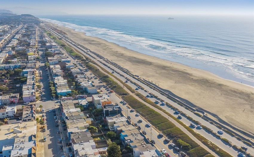
Introduction
    The construction of the federal Interstate system did not
    come without significant human and social cost. Built
    directly through cities, these highways and others like them
    displaced roughly one million people and left behind disjointed
    neighborhoods suffering the negative environmental and social
    effects.

    Freeways Without Futures tells the       through a highway’s construction and     stores and shops, or public services
    story of some of the worst highways      residents still live with its effects.   and amenities. Some have managed
    in America; the ones that have left a                                             to combine several of these uses in
    terrible legacy and incredible hurdles   In other places, new inhabitants         their reclamation of the freeway
    for the people who live around them.     occupied neighborhoods damaged by        space.
    But it also highlights the resilience    highways, as longtime residents who
    of neighborhood residents, local         had the means moved on. After the        After the 1989 Loma Prieta
    government officials, and activists      California Division of Highways built    earthquake, San Francisco’s
    fighting to remove these blighting       Interstate 5 through Boyle Heights in    Embarcadero and Central freeways
    highways and reconnect their             Los Angeles, a significant portion of    were damaged beyond safe use.
    communities.                             the neighborhood’s Jewish population     The city evaluated whether these
                                             moved away to the Westside. In           highways were necessary and
    Highway construction demolished          their place, a generation of Mexican     ultimately decided they were not.
    Main Streets and forced businesses       immigrants seeking inexpensive           Traffic disasters were predicted
    to close, disproportionately in Black    housing moved in, inheriting only the    when they closed but failed to occur.
    and brown communities. These             small sliver of Hollenbeck Park the      Boulevards replaced the freeways
    highways erased places that remain       highway didn’t destroy.                  instead, opening up the waterfront
    central to the community, like                                                    and uniting neighborhoods.
    Claiborne Avenue’s tree-lined neutral    No matter how people have
    ground in New Orleans or historic                                                 To date, 18 American cities either
                                             come to live around highways,
    Black Wall Street in Tulsa. After the                                             have transformed or are committed
                                             they face ongoing negative               to transforming freeways into
    highway, these areas were no longer
    recognizable; struck by a man-made       physical and psychological               community assets that provide
    natural disaster designed to serve the   impacts. Highways drive                  social, economic, and environmental
    needs of those living elsewhere.         disinvestment, create                    benefits to community members.
                                                                                      This number has been accelerating in
                                             unhealthy and toxic places to
    Unfortunately, some communities in                                                the last five years, with two projects
    the path of these highways unraveled     live, and inflict traffic violence       completed, four underway, and two
    to the point of disintegration. When     on surrounding communities.              more committed. These efforts have
    Rochester, New York opted to remove                                               drawn the attention and support of
    its Inner Loop and replace it with       Freeways Without Futures tells the       the federal government. Under the
    a boulevard, the community living        story of how the people who live         Obama administration, the United
    around the highway was no longer         near highways can repair, rebuild,       States Department of Transportation
    the same as the one living there when    and reknit their communities by          introduced the Every Place Counts
    the highway was built. Others, such      transforming the space these roads       Design Challenge, which supported a
    as New Orleans’ primarily Black          occupy into city streets, parks and      handful of these efforts with technical
    Tremé neighborhood, have persevered      green spaces, homes and apartments,      assistance. The Biden administration

4
Tulsa’s historic Black Wall Street in 1938, razed to make way
for I-244. Credit / Tulsa Historical Society & Museum

       has made reconnecting the
       communities divided by highways                    Inside This                               political momentum, redevelopment
                                                                                                    opportunities, potential cost savings,
       one of its priorities and Congress has
       taken the first steps toward a federal             Report                                    and potential to improve access
                                                                                                    to opportunity for underserved
       Highways to Boulevards program by                                                            communities.
                                                          The 2021 Freeways Without Futures
       introducing the $15b Reconnecting
                                                          report features 15 highways in            In each case, supporters have opted
       Communities Act in April.
                                                          American cities that are prime            to measure community progress and
       More support is needed. In cities                  for a transformation. The people          quality of life by a set of metrics other
       across the country, the injustices                 who live around them know                 than travel time:
       in the built environment that stem                 that they are problematic. Many
       from the era of highway building                   are poorly maintained and have
                                                          become liabilities instead of assets.
                                                                                                    Economic Gains.
       still support the separation of cities
       by race and class. Today, many of                  Straightforward solutions exist           When the Interstate system and
       these urban freeways are reaching the              to deal with the volume of traffic        other state highways first encroached
       end of their designed lifespans. As                they carry. Support for changing          on cities, they converted valuable
       debates at the federal level consider              these highways—to invest in new           land in the heart of downtowns
       infrastructure as a cornerstone for                transportation infrastructure that        and along waterfronts into traffic
       recovery from COVID-19 and                         meets multiple community goals—is         corridors that produce virtually no
       Americans are evaluating how to                    widespread.                               direct income for local economies.
       address systematic racism, where                                                             Cities that choose to remove or cover
                                                          To select these highways, CNU
       do urban highways and their legacy                                                           urban freeways have an opportunity
                                                          convened a national advisory
       fit? Will we reinvest in and rebuild                                                         to reclaim this real estate to serve
                                                          committee of transportation and
       these structures, continue to support                                                        community needs. Reclaiming the
                                                          urban design experts with urban
       highway expansion, and solidify                                                              land underneath highways can boost
                                                          highway removal experience. The
       the physical barriers that separate                                                          and stabilize populations of cities,
                                                          panel reviewed each submission based
       and destroy? Or can we envision a                                                            providing direct local control of land
                                                          on a number of criteria: the age and
       reparative infrastructure program that                                                       that can be dedicated to a range of
                                                          state of the highway, the quality of
       reknits communities, addresses the                                                           housing choices for individuals and
                                                          alternative boulevard or street design,
       damage these highways have caused,                                                           families, from affordable homes to
                                                          the feasibility of removal, community
       and increases access to opportunities                                                        workforce housing. Highway removal
                                                          support for removal, existing
       for legacy residents?                                                                        is a once-in-a-generation occasion to

                                                                                                                     FREEWAYS WITHOUT FUTURES 2021 / 5
Claiborne Avenue Alliance supporters spread the
message in New Orleans. Credit / Amy Stelly

                             revitalize downtowns, neighborhoods,        a strong public life and contributes to    Dismantling Racist
                             and waterfronts and strengthen              the civic character of the city.
                             local economies. Care must be given                                                    Policies and Actions.
                             to ensure that the legacy residents         A Healthy                                  An overwhelming amount of
                             directly benefit from these economic
                             gains and increased access to               Environment.                               evidence exists to demonstrate that
                                                                                                                    highway building was a tool to
                             opportunities.
                                                                         Choosing city streets over freeways        perpetuate racial segregation. As
                                                                         means leaving behind the hazards           early as 1939, the Bureau of Public
                             A Vibrant Public                            of highly concentrated vehicle             Roads, predecessor to the Federal
                             Realm.                                      exhaust near residences, businesses,       Highway Administration, identified
                                                                         and schools. Many urban highway            that highway building would facilitate
                             Highways fall flat in this metric,          segments run through the densest           “slum clearance”, a thinly-veiled
                             with negative rather than positive          parts of their cities, exponentially       reference to the destruction and
                             outcomes. Few people enjoy walking          increasing the number of people            displacement of communities of color.
                             underneath a highway, let alone             exposed to toxic fumes and                 Discriminatory lending practices like
                             spending time around it. However,           particulates from car and truck traffic.   redlining limited where Black and
                             streets and public spaces that are          Known health risks from proximity          brown residents forcibly moved by
                             dedicated to people, not cars, offer        to highways include increased              highway projects could live, further
                             members of the community places             rates of respiratory ailments and          amplifying the disproportionate
                             to relax, shop, and enjoy each other’s      cardiovascular illnesses. Extensively      effects highway building had on
                             company in public. Places like these        overbuilt highway infrastructure           these communities. Removing
                             were destroyed to make way for              encourages even more driving and           highways that still beset the Black
                             freeways. Now, there is opportunity to      perpetuates these conditions. This         and brown communities who live
                             create a new, vibrant public realm for      brief overview does not even take into     around them provides an opportunity
                             the communities that bore the brunt         account noise or the impact of being       to acknowledge the harmful and
                             of highway construction. A city’s           stuck in traffic, both of which are        destructive actions taken against them
                             public realm exists in its public spaces,   health hazards.                            over the last 70 years and repair the
                             the streets and squares that integrate                                                 damage.
                             individual buildings into a coherent
                             urban unit. When properly designed,
                             the space between buildings promotes

     6
Claiborne Avenue in New Orleans, before the
Claiborne Expressway. Credit / Amy Stelly

      The removal of a highway is not
      a silver bullet for every urban
      issue, but it is more than a simple
      transportation or infrastructure
      problem. It intersects with
      community health, fiscal
      responsibility, and equitable urban
      development. Cities that choose
      alternatives to highways have decided
      to prioritize people over vehicles
      and to address needs that have
      been underdeveloped in favor of
      automotive mobility.

      Highways to Boulevards projects will
      not deliver all these benefits unless
      they are driven by and designed in
      partnership with the communities
      who live around these highways.
      These residents are not only most
      impacted by the projects, they also
      live day to day with the ongoing
      trauma of living in a neighborhood
      severely damaged by infrastructure
      projects that do not benefit them.
      As these 15 projects move forward,
      it is imperative that state and local
      agencies make focused investments
      and develop intentional policies that
      set up legacy residents who have lived
      with the highway to thrive once they
      are no longer burdened by it.

                                               FREEWAYS WITHOUT FUTURES 2021 / 7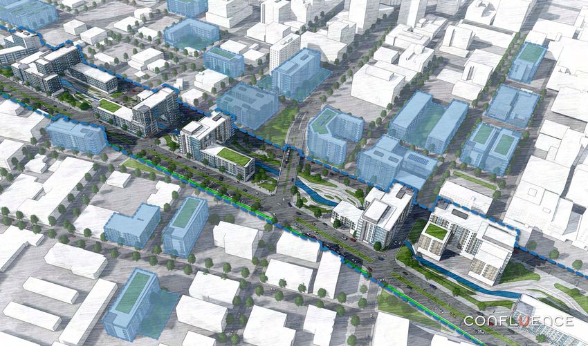
Freeways
    Without
    Futures
    Communities across North America are
    facing a watershed moment in the history
    of our transportation infrastructure. With
    cities, citizens, and transportation officials
    all looking for alternatives to costly highway
    repair and expansion, these 15 campaigns
    offer a roadmap to better health, equity,
    opportunity, and connectivity in every
    neighborhood, while reversing decades of
    decline and disinvestment.

8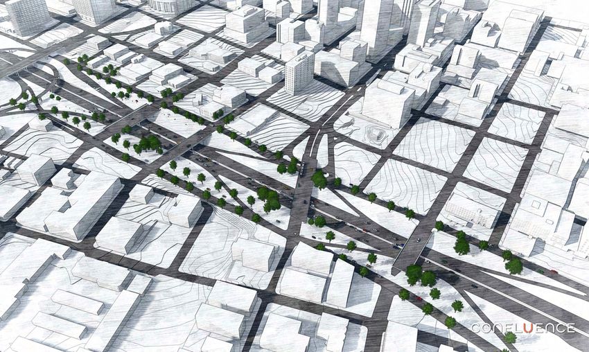
I-5
         SEATTLE, WA

                                      I-35                            Inner Loop
                                      DULUTH, MN                      North
                                                    Kensington ROCHESTER, NY
                                                    and Scajaquada   I-81
I-980                                               Expressways      SYRACUSE, NY
OAKLAND, CA
                                                    BUFFALO, NY
                                                                                 Brooklyn-Queens
  The Great Highway
  SAN FRANCISCO, CA                                                              Expressway
                                                                                 NEW YORK, NY
                                          North Loop (I-35/70)
                                          KANSAS CITY, MO

                          I-244
                          TULSA, OK

                                      I-345
                                      DALLAS, TX
                                                   Claiborne
                       I-35                        Expressway (I-10)
                       AUSTIN, TX                  NEW ORLEANS, LA

                                                                     I-275
                                                                     TAMPA, FL

                                                                  FREEWAYS WITHOUT FUTURES 2021 / 9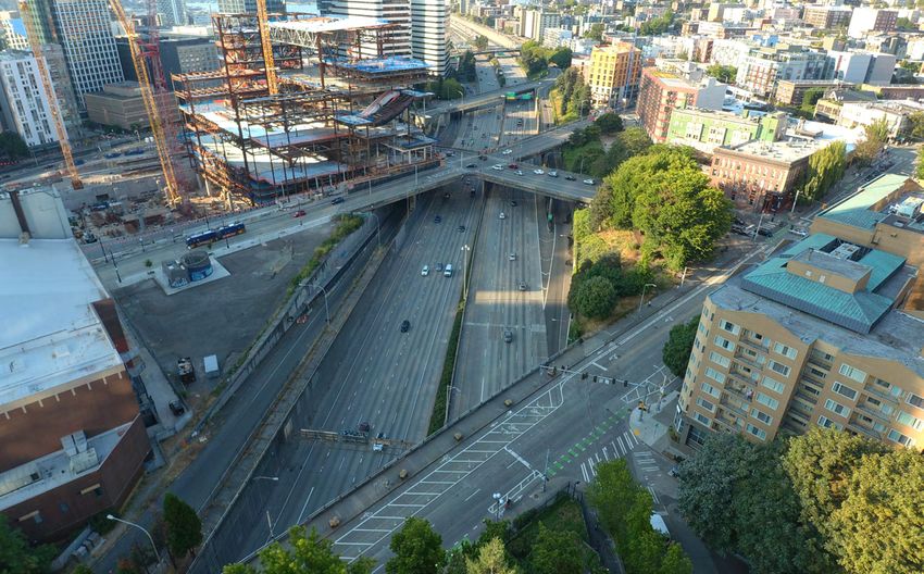
The Brooklyn-Queens Expressway through
Brooklyn Heights. Credit / Florin C.

                   Brooklyn-Queens                              The Brooklyn-Queens Expressway
                   Expressway                                   (BQE) represents the paradox of famed
                   NEW YORK, NEW YORK                           highway builder Robert Moses’ legacy.
                   HIGHWAY TYPE
                                                                The roads, parks, bridges, and housing
                   Hybrid depressed, cantilevered, and          he constructed that reshaped New
                   elevated Interstate highway
                                                                York City and Long Island to serve
                   YEAR BUILT
                   1946-1964                                    the public resulted in the displacement
                   STAGE OF REMOVAL
                                                                of thousands of families, destruction
                   Advocates are actively building support
                   to reduce the highway’s impact on
                                                                of tight-knit neighborhoods, and
                   surrounding communities
                                                                overall were built at the expense of
                   KEY CHARACTERISTICS
                   The Brooklyn-Queens Expressway links
                                                                innumerable people and communities
                   Staten Island to the Bronx and has several
                   elevated segments and trenches in need of
                                                                of color. The BQE is no exception.
                   repair that will require action soon.
                                                                Today, as the aging highway crumbles,
                   Residents and transportation experts have
                   questioned whether the highway can be
                   rebuilt in ways that have less impact on
                                                                New York City needs to decide if there’s
                   surrounding neighborhoods or if the road
                   is even necessary.
                                                                a better way forward.
  10
Rendering of a redesigned Brooklyn-Queens Expressway
through Brooklyn Heights. Credit / Marc Wouters Studios
The current path of the Brooklyn- While that plan was halted through particular neighborhoods and others
Queens Expressway (BQE), at least the efforts by several area organizations, the more wide-sweeping. The Cobble Hill
portion in Brooklyn Heights, was built developments also sparked conversations Association has called for a cap over the
out of compromise. To the south, Robert about what to do with the remaining trenched part of the highway in their
Moses built a tall elevated highway ten miles of the BQE that run through neighborhood. Marc Wouters Studios’
directly through the working-class Red some of the densest parts of Brooklyn has proposed a relatively low cost series
Hook neighborhood, separating it from and Queens. of public terraces that would extend
the rest of the borough. It then cuts the promenade over a reduced-width
a wide trench through Cobble Hill. It is clear that the highway has highway. New York’s Institute for
Moses originally intended the highway a detrimental effect on every Public Architecture focused its Fall 2020
to continue straight through Brooklyn neighborhood that it passes through, residency on what could be built in place
Heights, but community protests against although some are more seriously of the BQE if the highway was removed
this plan prevailed. Instead, the BQE affected than others. In particular, altogether. These are just a handful of the
skirted the edge of Brooklyn Heights the wide footprint of the viaducts ideas that grapple with the problematic
in its current form as a multi-level through the Navy Yard and Greenpoint BQE.
cantilevered roadway that forms an neighborhoods have facilitated the
effective wall between Brooklyn and design of auto-centric streets underneath While these plans differ in scope and
its waterfront. The popular Brooklyn them that are dangerous for pedestrians scale, they share a single principle:
Heights promenade was also built as to cross. The trenched portion in Cobble they all seek to repurpose the space the
part of this compromise. Hill can only be crossed at a limited highway occupies in ways that improve
number of access points. And the entire the quality of life for residents along the
Because the Brooklyn Heights section highway subjects thousands of nearby corridor. As New York City and State
is in dire need of repair and immediate residents to the concentrated exhaust of consider what to do with the outdated
action, planning for the future of this over 150,000 vehicles per day, many of expressway in Brooklyn Heights, they
part of the road has received the majority which are funneled to the BQE to travel should follow this lead and make
of attention as of late. In particular, the toll-free Brooklyn and Manhattan sure to prioritize all neighborhoods
a plan to temporarily transform the Bridges. along the corridor before they develop
Brooklyn Heights promenade into a future plans. The transformation of the
highway while the BQE below it was To remedy these issues, a wide variety BQE offers a once-in-a-generation
repaired over several years drew a lot of organizations have put forward opportunity to create a more livable
of ire and raised questions about how alternate visions for the future of Brooklyn and Queens and should be
best to go about rebuilding the road. the BQE, some of them limited to seriously considered.
FREEWAYS WITHOUT FUTURES 2021 / 11Underneath the Claiborne Expressway.
Credit / Julia Schlau
Claiborne Expressway When the bulldozers arrived on
(Interstate 10) Claiborne Avenue in 1966, they did
NEW ORLEANS, LOUISIANA more than uproot the century-old oak
trees that lined its park-like median,
HIGHWAY TYPE
Elevated Interstate highway they destroyed a landmark central
YEAR BUILT to the Tremé neighborhood’s Black
1966-1968
community. Now, to remedy this
STAGE OF REMOVAL
Outreach and coalition building — advocates
wrong, the Claiborne Avenue Alliance
are actively building support for removal has led a renewed effort to take down
KEY CHARACTERISTICS the expressway, reclaim this historic
The Claiborne Avenue Alliance wants to
remove the Claiborne Expressway and recreate neutral ground for Tremé’s residents,
the historic tree-lined Claiborne Avenue as a
path toward community revitalization. and provide a pathway for community
A restored Claiborne Avenue would serve as
the backbone for a restored business corridor revitalization.
that brings services and jobs back to the
Tremé neighborhood.
12Claiborne Avenue restored., with
a bandshell atop the highway’s
pylons. Credit / Amy Stelly
Each year during Mardi Gras, thousands strides championing a community and resell it at below market value to
of people wind their way underneath vision for a Claiborne Avenue restored. residents is a critical strategy to help
the Claiborne Expressway along what Previous studies had emphasized the renters (70% of the community as of
used to be Claiborne Avenue’s median. development potential associated the 2010 census) transition to home
For these few hours, the grey pavement with the expressway’s removal, which ownership and stay in the neighborhood.
of the parking lots below the highway is prompted long-time residents to think Additional strategies, such as incentive
transformed back into a gathering space this was another infrastructure project programs that assist residents with home
for the community. Tree-lined Claiborne that would benefit someone else, again at maintenance and tax-freezing programs
Avenue wasn’t the only focal point the their expense. to relieve the escalating assessments
highway deprived residents of. Dozens already driven by short-term rentals, will
of Black-owned shops, restaurants, and The Alliance’s plans instead seek to help keep residents in place to enjoy the
clubs shuttered in the years following channel the benefits unlocked by taking benefits of a restored Claiborne Avenue.
the highway’s construction. down the expressway to serve the
members of the current community. Currently, the Alliance is building
Fast forward to the present day and First and foremost, it advocates for the support for this vision. It launched
those who live and work near the restoration of the median to its former its Paradise Lost|Paradise Found
highway are exposed to excessive noise state and restoring the lost tree canopy. poster campaign in January 2020,
and harmful pollutants. The highway is This gathering space will serve as the which brought public awareness to
now crumbling so hot, dirty runoff pours backbone for a revitalized business the damage caused by the Claiborne
into the neighborhoods during rains, corridor that brings goods and services Expressway and the potential for a
exacerbating flooding. Furthermore, the back to the neighborhood. There is also brighter future without it. Its work
Louisiana State University School of the opportunity to create affordable has even received recognition from
Public Health confirmed that pollution housing through infill development and President Joe Biden, who identified
from the Interstate has a major impact the rehabilitation of the existing homes the Claiborne Expressway as a prime
on the respiratory health of residents, that have fallen into disrepair. example of a highway built at the
making their battle with COVID-19 expense of the community around it.
harder. All of this is underpinned by policies Mayor LaToya Cantrell and incoming
the city can adopt to protect current U.S. Representative Troy Carter have
Discussions about removing the residents from being displaced by rising both expressed support for taking down
Claiborne Expressway span back over prices once the highway is removed. the expressway and become part of a
a decade and since 2017, the Claiborne The early establishment of a community growing consensus that its removal is the
Avenue Alliance has made great land trust to acquire available real estate right course of action for Tremé.
FREEWAYS WITHOUT FUTURES 2021 / 13Inner Loop North. Credit / Robert Keck
Rochester is looking to pick up where it
Inner Loop North
left off. In 2017, the City completed its
ROCHESTER, NEW YORK
transformation of the eastern portion
HIGHWAY TYPE
Depressed highway
of the Inner Loop into an urban street,
YEAR BUILT
which has already paid significant
1952-1965
dividends. Now, as the City considers
STAGE OF REMOVAL
Study and public comment— full or partial
what to do with the northern part of
removal options are being considered in
official studies
the Inner Loop, it has the opportunity
to replicate this success and focus
KEY CHARACTERISTICS
Rochester completed the removal of the Inner
Loop East in 2017. It’s looking to build on
even more on creating outcomes
that success by removing the Inner Loop
North.
that support a cohesive and inclusive
With this project, the City is looking to create community.
community assets with an emphasis on green
space and a focus on racial equity.
14Rendering of a restored Franklin Square in place of the
Inner Loop (inset: current conditions). Credit / Bergmann
For decades, Rochester’s 2.68-mile Inner All this sets the stage for the Inner findings is residents’ desire for housing
Loop acted as a moat between its central Loop North. Rochester is now exploring that better fits neighborhood character
business district and adjacent residential options for removal of this part of and different living situations. Four
neighborhoods. It presented a major the highway, which runs from I-490 story buildings, full of one- and two-
barrier to both walking and biking to to the intersection of Union Street bedroom apartments, don’t address the
and from downtown and had become a and Main Street. While the City has needs of all community members, even if
liability as much of it fell into disrepair yet to commit to any specific design they include affordable units. Residents
and the number of cars traveling on it for the project, it has laid out a set of would rather see a mix of housing types,
continued to decline. The Inner Loop guiding principles: it should improve including smaller homes that are often
East Transformation Project was the connectivity, increase multi-modal described as ‘missing middle’ housing.
City’s first step to address the issues the transportation options, create new green The City and its partners should take
Inner Loop has caused. The removal of spaces, and foster opportunities for this into serious consideration as
the Inner Loop’s eastern portion was economic and community development they think about creative options for
low-hanging fruit, as only 10,500 cars a in surrounding neighborhoods, home affordability and avoiding displacement
day drove that part of the highway. to a predominantly Black and brown following removal.
population. With a focus on racial equity,
The transformation of the Inner Loop the project aims to prevent displacement Rochester’s success with the Inner
East has served as a demonstration of existing residents and businesses. Loop East garnered national attention.
project for highway removal in other Preliminary concepts estimate around With the removal of the Inner Loop
parts of the city. Since the project started 15 acres of land could be reclaimed for North, the city has the opportunity to
in 2014, walking increased 50 percent development, along with several acres of once again be at the forefront of the
and biking 60 percent in the area. The green space. Highways to Boulevards movement. It
city was also able to reclaim 6.5 acres of should lead the way by doing everything
land for development by filling in the A group of community members, in its power to listen to residents and
highway. The current plan for this land is Hinge Neighbors, is also working incorporate their ideas into the project’s
to develop 534 housing units, more than with residents on both sides of the final designs. At the same time, the City
half subsidized or below market rate, and Inner Loop to raise awareness about should also explore all the policy tools
152,000 square feet of new commercial the impacts the project will have and it can use to support residents and their
space. Work is already underway and communicate local needs and desires to visions. If Rochester follows through on
over the first two years the removal the City and its consultants. To gather these commitments, it will be a model
project, which cost only $22 million in more information, they’ve launched a for future highway removal projects
public funds, generated $229 million in community survey, which has had some prioritizing equity.
economic development. telling results. One of their significant
FREEWAYS WITHOUT FUTURES 2021 / 15I-244 through Deep Greenwood.
Credit / Daniel Jeffries
Interstate 244 Interstate 244 runs directly through
Tulsa’s Greenwood district, the historic
TULSA, OKLAHOMA
center of the city’s African-American
HIGHWAY TYPE community once known famously as
Hybrid elevated and at-grade Interstate
highway ‘Black Wall Street’. In 1921, a mob of
YEAR BUILT white Tulsans, provoked by misleading
1965-1975
newspaper headlines, descended upon
STAGE OF REMOVAL
Outreach and coalition building — advocates Black Wall Street, killing at least 100
are actively building support for removal
people (but likely many more) and
KEY CHARACTERISTICS
Interstate 244 bisects Tulsa’s Greenwood
destroying the 2019 equivalent of
district, once home to a thriving Black
neighborhood known as Black Wall Street.
more than $32m worth of property.
Removing I-244 will increase the connections
Greenwood’s Black community quickly
between Greenwood’s remaining community
assets and the rest of north Tulsa.
reestablished itself and returned
Taking down the highway won’t restore Black
even more triumphant, only to be
Wall Street by itself, but can be part of a
larger plan toward community revitalization.
razed again decades later by highway
builders.
16Aerial photograph of Greenwood in 1951, with the
future path of I-244. Credit / Michael Bates
With the end of legal segregation in the the Greenwood Cultural Center, built with the highway’s removal, can support
early 1960s Greenwood’s businesses had in 1980 to celebrate the achievements community efforts to build a new Black
experienced a bit of a decline, as Black of Black Wall Street residents and Wall Street. This includes programs
spending was no longer concentrated remember the tragedy of the race to help develop new Black-owned
exclusively in the district. But it still massacre. businesses and boost existing ones,
remained a source of community pride. leveraging the City’s Affordable Housing
I-244’s construction put an abrupt end These community assets could serve Trust Fund to create affordable homes
to any potential revival. The businesses as the foundation for a revitalized within walking distance, and establishing
in the highway’s path closed or relocated Greenwood following the removal of a community land trust to rehabilitate
elsewhere, away from their traditional the northern section of I-244 along the vacant lots and abandoned houses in
customer bases. In 1942, Greenwood was IDL. The concept is a nascent one, but line with residents’ interests. It will take
home to 242 Black-owned businesses the Tulsa Regional Chamber, Historic focused investments and intentional
spread over 35 square blocks. The Greenwood District Main Street, and policies like these to rebuild an expanded
highway reduced that number to only a other local advocates think it is worth Greenwood district that does justice to
handful, most situated on the 100 block exploring. I-244 acts as a physical historic Black Wall Street, while also
of Greenwood Avenue, which local barrier between predominantly Black addressing displacement concerns.
attorney E.L. Goodwin, Sr. had saved north Tulsa and historic Greenwood
through negotiations. Avenue and downtown to the south. This year marks the centennial of the
By removing the highway and restoring Tulsa Race Massacre, when Black Wall
Today, I-244 in Greenwood forms the street connections, north Tulsans Street was first destroyed. Now would
northern part of a series of highways would be able to more easily walk or be a fitting time to carry forward a
known as the Inner Dispersal Loop bike downtown, and business owners conversation about I-244’s removal.
(IDL) that cordons off downtown in Deep Greenwood would benefit Preliminary investigation suggests it
from the rest of Tulsa. Parts of historic from increased traffic. New land would is more than feasible. This one-mile
Black Wall Street remain in its shadow, also be available to expand Deep segment of I-244 is hardly essential for
including the 100 block of Greenwood Greenwood northward, where it is regional travel and Tulsa has a second
Avenue (also known as Deep largely constrained by the presence of loop highway, the Gilcrease Expressway,
Greenwood) and a pair of churches (the the highway. only a few miles to the north. The
Mt. Zion Baptist Church and Vernon outstanding question is how to best
AME Church) that were burned down Of course, the removal of I-244 alone ensure the highway’s removal and a
during the race massacre but rebuilt won’t restore Black Wall Street. But subsequent restoration of Greenwood
afterward. Just north of the highway is coordinated reparative programs, coupled helps Black Tulsans heal and thrive.
FREEWAYS WITHOUT FUTURES 2021 / 17The interchange of I-275 and I-4.
Credit / #blvdtampa
Interstate 275 Like many highway removal
TAMPA, FLORIDA
campaigns, the push to replace
Tampa’s I-275 with a boulevard
HIGHWAY TYPE
Hybrid elevated and at-grade Interstate grew out of a proposed
highway
expansion of the highway.
YEAR BUILT
1962-1964
When the Florida Department
STAGE OF REMOVAL
of Transportation pitched in
Study and public comment— removal is being 2016 an unpopular plan to add
studied as one possible alternative in official
study lanes and expand the right-of-
KEY CHARACTERISTICS way, it spurred a conversation
The #blvdtampa movement has an ambitious
plan to convert up to 11 miles of I-275 in about the highway’s negative
effects on the neighborhoods
northern Tampa into a multi-use surface
boulevard that provides public transit in one of
the country’s most underserved areas.
The Hillsborough County Metropolitan it passes through and whether
Planning Organization has committed to
studying the removal of I-275 as part of its it actually provides the most
efficient way to travel.
long-range plan.
18Proposed cross-section of a boulevard replacing I-275 (above), with current
cross-section of I-275 (below). Credit / #blvdtampa
In many ways, the Florida Department limits. Since the Interstate isn’t operating local context and change accordingly so
of Transportation’s (FDOT) original as a throughway (its intended purpose), that the density built around it gradually
$6b expansion plan for I-275 replicated could another type of street handle increases as it approaches downtown.
its past transgressions. To widen the traffic and achieve other community
road, FDOT needed to seize around goals at the same time? The Tampa region is already taking the
400 properties and of the residents who initial steps needed for the boulevard
would have been displaced, nearly 80 #blvdtampa and its allies have set out plan to become reality through
percent were Black or Latino. Fifty- to prove the benefits the city could reap incremental endeavors to update its
four years earlier, FDOT did the same by transforming up to 11 miles of I-275 transportation networks. In 2022,
thing when building the highway. The in northern Tampa into a multiway Hillsborough County voters expect
construction of I-275 did incalculable boulevard, a type of landscaped street to vote again on a ballot measure that
damage to Tampa’s rich ethnic and that separates through traffic from would fund additional transit routes with
historic neighborhoods, including Ybor local traffic and creates an engaging faster service, which overwhelmingly
City and Central Park. pedestrian realm. Because I-275’s right- passed in 2018 but was struck down
of-way is so large, the opportunity exists by the Florida Supreme Court on a
Under intense criticism, FDOT backed to fit public transit into its footprint, controversial technicality.
off its expansion plans and has decided either in the form of light commuter rail,
instead to add lanes within the existing bus rapid transit, or a modern streetcar, Most significantly, in 2019 the
right-of-way. But by then Tampa further reducing the need for trips by car. Hillsborough County Metropolitan
residents had already begun to consider Planning Organization committed to
whether the highway’s useful life was The transformation of I-275 into a study transforming the highway into a
coming to an end, particularly as the boulevard also prepares Tampa for boulevard as part of its long-range plan.
city looked to update its transportation future sustainable growth. A boulevard What once was seen as a fringe idea
system for the 21st century. along this route provides Tampa a new has built momentum and spread around
urban spine that links its residential Tampa Bay. Neighboring St. Petersburg
Enter Josh Frank, one of the founders neighborhoods with downtown. Mayor Rick Kriseman has said that his
of the #blvdtampa movement, which The removal of the highway would city should explore removing I-175,
envisions a future for Tampa without reclaim 36 acres of developable land which separates downtown from nearby
I-275. Frank examined traffic patterns in neighborhoods that are some of the neighborhoods. In this context, the
along I-275 and saw that the majority most protected in Tampa from rising transformation of I-275 has become
of vehicles that travel it have both local sea-levels. With a flexible boulevard as part of a larger effort to improve
origins and destinations within city design, the new street can be sensitive to transportation options across Tampa Bay.
FREEWAYS WITHOUT FUTURES 2021 / 19I-345. Credit / Kelsey Shoemaker
Interstate 345 For nearly a decade, local advocacy
group A New Dallas has repeatedly
DALLAS, TEXAS
demonstrated the enormous benefits
HIGHWAY TYPE
Elevated Interstate highway
of removing I-345 to the Texas
YEAR BUILT
Department of Transportation
1973
(TxDOT). And TxDOT appears
STAGE OF REMOVAL willing to listen. As the official
Study and public comment — removal is
being studied as one possible alternative in
official study
feasibility study for I-345 moves into
its final stages, a street network option
KEY CHARACTERISTICS
Local advocacy group A New Dallas has remains on the table, supported by
shown the removal of I-345 as a path towards
a more connected and accessible Dallas. TxDOT’s own 2016 CityMAP plan.
The upside of removal is enormous—up to
375 acres of land could be reclaimed and
I-345 has all the characteristics of a
redeveloped for homes, transit, schools, and
parks. highway prime for removal.
The Texas Department of Transportation is
now reviewing removal as a possible option in
its feasibility study for I-345.
20Rendering of a boulevard replacing I-345. Credit / TxDOT
This 1.4-mile stretch of highway forms The removal of I-345 can also bring revenues to neighborhood stabilization
an imposing concrete barrier that much needed housing to the Dallas and equitable development programs
divides the city’s historic Deep Ellum market. At the moment, the I-345 in areas of need where displacement
neighborhood from downtown and has corridor is defined primarily by is a concern. This will help ensure that
spawned vacant lots and disinvestment empty parking lots and undeveloped residents will not only have access to
along its path. Back in 2013, residents land because the highway is such a newly built affordable housing, but also
Patrick Kennedy and Brandon Hancock disamenity. But its transformation into a that they are able to remain in their
recognized the highway had become mixed-income, mixed-use neighborhood current homes if they so desire, ideally
a liability and together, they founded would open up more opportunities to with opportunities for renters to build
the group A New Dallas. Since then, build affordable housing and improve equity.
the group has demonstrated the social, the quality of life for Dallas residents.
economic, and environmental benefits A New Dallas has since grown into TxDOT is expected to make a decision
for a Dallas without I-345. The Coalition for a New Dallas, about a preferred alternative sometime
a non-profit and Political Action this year. While other options may
It wasn’t long before TxDOT began Committee composed of a broad and mitigate the negative effects of the
to take notice and agreed to further diverse group of advocates and civic highway, for The Coalition for a New
investigate what I-345’s removal might leaders. This group has since brought Dallas there’s only one clear winner: the
mean for Dallas. In 2016, it unveiled the in Toole Design Group to take a fresh removal of I-345 and its replacement
Dallas CityMAP plan, which confirmed look at the CityMAP plan in order to with a robust newtork of urban
that the effects of removing I-345 improve design options and demonstrate boulevards. Dallas is already making
would be overwhelmingly positive. The feasibility. investments to transform itself from
removal of the elevated highway would an auto-centric city to one that is more
open up 375 acres of urban land for As plans are put in place for the livable, including the expansion of its
development—with the potential for highway’s removal, The Coalition for subway system that will traverse the
walkable urban blocks and quality public a New Dallas thinks that it’s critical I-345 corridor. If TxDOT does its part
spaces. The complete removal, a public for the city to take steps to combat and removes I-345, this will become
investment estimated to cost between displacement that could result from such a coordinated effort to make Dallas a
$100-$500m, would generate at least a serious improvement. The coalition city where all its residents can enjoy
$2.5b in new property value, supporting proposes a variety of value capture and the benefits of jobs and basic services—
both the city’s tax base and a growing equitable development strategies where housing, transit, schools, parks, and
economy as the resulting development the land values are expected to be the retail—available within a short distance.
would also create 39,000 new jobs. highest and diverting some projected
FREEWAYS WITHOUT FUTURES 2021 / 21Rendering of an expanded I-35.
Credit / TxDOT
Interstate 35 Everyone in Austin agrees that
Interstate 35 doesn’t work. The highway
AUSTIN, TEXAS
was built to act as a chasm between
HIGHWAY TYPE
Hybrid elevated and at-grade Interstate downtown and communities of color
highway
in East Austin, and is the city’s most
YEAR BUILT
1962 dangerous corridor for pedestrians. It is
STAGE OF REMOVAL
clear that in its current form I-35 serves
Study and public comment — capping is being
studied as one possible alternative in official no one particularly well and as the
study, while other advocates are building
support for removal Texas Department of Transportation
KEY CHARACTERISTICS
(TxDOT) considers what to do
The Texas Department of Transportation is
proposing a massive expansion of I-35 through
next, Austin residents have begun
Austin to as many as 20 lanes.
questioning whether there’s a better
Local groups, including Reconnect Austin,
Rethink35, and the Downtown Austin solution than simply rebuilding and
Alliance, have proposed other solutions
that reduce the highway’s impacts on expanding the highway.
neighborhoods, provide mobility choice and
safety, and achieve community goals.
22View of I-35 from E. 5th Street, looking
east. Credit / Reconnect Austin
Rendering of E. 5th Street without I-35.
Credit / Reconnect Austin
Proposed plan for East Avenue Parkway.
Credit / Reconnect Austin
TxDOT is adamant that there is for the overly-wide frontage roads that automobile dependency, and induced
only one solution for I-35’s woes: a facilitate cars getting on and off the sprawl as to why I-35 should be
$4.9b highway expansion to up to 20 highway. Through the combination of removed. All three of these coalitions
lanes. This proposal hinges on traffic capping the highway, shrinking the recognize I-35 in its current form as a
forecasts that opponents say consistently street on top of it to a more fitting liability for Austin and seek different
overestimates actual levels. A growing size, and eliminating frontage roads, ways to create assets along the corridor
number of people realize that highway Reconnect Austin’s plans reclaim over that provide community benefits.
expansion induces even more demand 130 acres of land for development, of
for driving, which quickly fills up the which 24.4 acres would be directly As TxDOT considers what to do with
newly-created capacity and leaves adjacent to downtown. The opportunity I-35, it needs to stop thinking about the
congestion as bad or worse. To learn this to reclaim this land and create an highway in a vacuum and instead should
lesson, TxDOT needs to look no further affordable housing supply, immediately focus on how its investments can achieve
than Houston, where traffic on the Katy adjacent to jobs, would reduce the multiple goals simultaneously. Austin’s
Freeway, expanded up to 26 lanes in number of commuters on the road. citizens have made clear their desires for
2008, has only gotten worse since it was the future of transportation and it is not
widened. Other groups in the area are also more highway building. On the 2020
thinking about how to change I-35. In ballot, Austinites voted overwhelmingly
So what else can be done for I-35? 2019, the Urban Land Institute report to fund Project Connect, a $7.1b
Local advocacy group Reconnect Austin for the Downtown Austin Alliance initiative to greatly expand the city’s
has long pushed for a solution that proposed caps at several key locations public transit, and to invest $460m in
keeps I-35 within its current footprint, to create blocks-long park spaces, walking, bicycling, and safer streets.
depresses 3.4 miles of it (from Holly similar to the Klyde Warren Park in Project Connect is also notable in that
Street to Airport Boulevard), and Dallas. Another group, Rethink35, its budget includes $300 million in
covers it with a cap. On top of the proposes removing 8 miles of I-35 anti-displacement funds and so provides
cap, Reconnect Austin proposes a new altogether and replacing it with a a template for keeping residents in
boulevard consistent with Austin’s Great boulevard that includes regional trains, place when infrastructure investments
Streets Master Plan, which includes bus lanes, protected bicycle lanes, increase a neighborhood’s amenities, like
generous space for pedestrians, cyclists, and wide sidewalks and incorporates a highway cap. With I-35, TxDOT’s
and dedicated transit lanes. anti-displacement measures for nearby should follow Project Connect’s lead and
communities. Inspired by previous make sure its actions work in concert
Reconnect Austin’s plan has a lot of freeway removals, Rethink35 points with Austin’s own plans for its future.
merit. It separates local traffic from toward climate change, traffic crashes,
through traffic, eliminating the need
FREEWAYS WITHOUT FUTURES 2021 / 23I-35. Credit / Duluth Waterfront Collective
Interstate 35 In Duluth, the 1,569-mile long I-35
DULUTH, MINNESOTA
comes to its northern terminus. It
ends unceremoniously at a four-way
HIGHWAY TYPE
At-grade Interstate highway
intersection, but not before it bisects
YEAR BUILT
Duluth’s downtown and separates it
1967-1991 from its Lake Superior waterfront.
STAGE OF REMOVAL A coalition of residents, the Duluth
Outreach and coalition building — advocates
are actively building support for removal Waterfront Collective, is seeking to
KEY CHARACTERISTICS restore this connection and create a
Duluth is the second smallest community to be
included in a Freeways Without Futures report more vibrant city center by replacing
and a poignant reminder that highway building
doesn’t only damage big cities. the highway with a street that integrates
The Duluth Waterfront Collective, the
coalition seeking to remove I-35, has made
downtown and the waterfront. The
community engagement its priority, long before
any official planning process has started. work of this coalition offers a valuable
The removal of I-35 will reintegrate Duluth’s
popular Canal Park with the rest of the city.
lesson: highway building can be just as
damaging for small cities too.
24Rendering of a parkway to replace I-35.
Credit / Duluth Waterfront Collective
A highway that consumes nearly 20% limits local travel to and from Canal reclaims 20 acres of land from the
of all space in Duluth’s downtown, Park, with the result that few of the highway that can be developed in ways
is extremely at odds with the city’s park’s visitors make their way into that alleviate considerable housing
population of 85,618 people. Residents Duluth’s downtown and spend money concerns and provide entrepreneurial
recognized this from the start. After there. Uphill from downtown is Duluth’s opportunities for members of the
the initial portion of the highway Central Hillside neighborhood, which community. It’s a catalytic opportunity
was built through West Duluth and is one of the city’s most diverse. It has to revitalize Duluth’s downtown and
Lincoln Park, residents formed the a high number of residents living in help the city fund services for residents
Citizens for Integration of Highway poverty, many of whom do not own by increasing its tax base. The Duluth
and Environment in an attempt to steer cars. The presence of I-35 limits their Waterfront Collective has estimated
the highway’s path as it approached enjoyment of the waterfront as well. that the removal of properties to make
downtown. The group ultimately way for I-35 has cost the city over $3.5
thwarted a plan to build the highway As a replacement for the highway, the million in lost tax revenue each year
directly along the waterfront, preserving Duluth Waterfront Collective envisions since construction started in 1967.
that natural asset, but were unsuccessful a new parkway that condenses I-35
in keeping the freeway out of the city’s and Railroad Street, but would only Most importantly, the Duluth
downtown entirely. increase through travel times by a few Waterfront Collective stresses that its
minutes. The parkway is planned to be proposed plans are a ‘living concept’,
Current conditions make it very much more accessible to pedestrians which it updates based upon feedback it
appealing to remove the portion of I-35 and cyclists, with wide sidewalks lined receives from the community. The group
that runs through downtown, which by trees and a new cross-city recreation has taken to conducting the outreach
the Duluth Waterfront Collective trail. It’s current iteration calls for typically undertaken by planning
advocates for. Traffic on the highway is dedicated space for bus rapid transit, agencies, hosting monthly meetings to
incredibly light for an Interstate, totaling and includes a rail corridor for the local discuss the proposal with community
only 32,000 trips per day. Meanwhile, tourist excursion train and potential members and stakeholders. From this
the Canal Park neighborhood and future transit options. In the center engagement, the Duluth Waterfront
the preserved green space along the of the parkway, a landscaped median Collective will have assembled a
waterfront have become some of the will provide even more green space in community vision for what a great
most visited places in Minnesota, yet addition to capturing stormwater from downtown should be, which they can
much of the Duluth community is the hillside and floodwater from the lake. present to the Minnesota Department of
unable to enjoy it as an amenity. With Transportation the moment it considers
limited places to cross, the highway The current iteration of the plan also what to do with the highway.
FREEWAYS WITHOUT FUTURES 2021 / 25I-5. Credit / Lid I-5
Interstate 5 Early on, Seattle pioneered a new way
of thinking about the relationship
SEATTLE, WASHINGTON
between city and freeway with the
HIGHWAY TYPE
Depressed Interstate highway
construction of Freeway Park over I-5
YEAR BUILT
in downtown. Today, the highway is
1962-1967
overdue for safety upgrades, including
STAGE OF REMOVAL earthquake retrofitting, presenting the
Outreach and coalition building — advocates
are actively building support to cap a portion
of the highway
perfect opportunity to expand this lid
and better serve people, not just cars.
KEY CHARACTERISTICS
In 1976, Seattle built one of the earliest caps,
Freeway Park, over Interstate-5.
The Lid I-5 movement seeks to build
Advocacy group Lid I-5 supports a plan
on Freeway Park’s legacy and spark a
to expand the cap as a way to reconnect
Downtown neighborhoods and address equity,
citywide conversation about what can
sustainability, and community needs.
be done with highways that damage
communities.
26Rendering of an expanded lid over I-5. Credit / Lid I-5
When discussions first began around Way Viaduct that covered its waterfront, calibrated to suit local needs. That
the construction of I-5, some Seattle opening up this unique natural resource opportunity is expected to be coming
residents recognized that the highway for the enjoyment of its residents. soon. The City of Seattle has taken
would have consequences: notably an interest and recently completed a
increased pollution and significantly less Since 2015, the advocacy group Lid I-5 feasibility study for the project, which
street connectivity across the highway. has sought to expand on these successes demonstrated that lidding more of I-5 is
The First Hill Improvement Club was and has worked with the public on new both technically feasible and potentially
vocal that the highway builders needed design concepts that could add another desirable, as it can significantly improve
to mitigate the road’s effects with 17 acres of lid area over I-5. The group the quality of life for residents.
lids and other measures. Georgetown recognizes that an expanded I-5 lid
residents also sought to preserve the can simultaneously address several of Lidding I-5 has the potential to
Georgetown Playfield in full. Both of the pressing challenges Seattle faces. transform downtown Seattle with a
these requests went unanswered. Only in Downtown Seattle lacks sufficient green win-win opportunity to address equity
1976, nine years after the highway was space, and the expansion of the lid issues, boost resilience, add green space,
completed, did the City of Seattle step could create more for the 40,000 people and improve public and environmental
in and support the creation of Freeway who would live only a 15-minute walk health. In addition, it can spark
Park, a 4.9-acre green space over the or less away. The same residents who important conversations related to
highway that at least partially restored lack easy access to green space are also other highways across Seattle and how
lost connections to First Hill. The park concerned about displacement risks, they impact the neighborhoods around
became one of the earliest examples in which have increased in downtown since them. As the city continues to explore
the country of a freeway lid. 2010. An expanded lid over I-5 could options to cover I-5, it should also look
provide new land on which to build to partner with less well-resourced
Since then, Freeway Park has been affordable housing in the heart of a neighborhoods that are bisected by
expanded several times to encompass diverse neighborhood with both a high freeways (like SR 99 in South Park)
a total of 5.2 acres. And it isn’t the displacement risk and high access to to develop remedies that lessen or
only effort that Seattle has undertaken opportunity. eliminate their negative effects. This
to remove or mitigate the effects of larger, coordinated effort could build
intrusive highways. Interstate 90 in the Rather than endorsing one particular on Seattle’s past accomplishments and
Mount Baker neighborhood is partially concept for what gets built on top of the ensure that all the city’s residents benefit
covered by a 10.3-acre lid that supports freeway, Lid I-5 remains purposefully from forward-thinking design.
a regional trail and Sam Smith Park. flexible so that the greater community
In 2019 the city removed the Alaskan can weigh in on plans that can be
FREEWAYS WITHOUT FUTURES 2021 / 27Underneath I-81 near Pioneer Homes.
Credit / Bob Haley
Interstate 81 In 2019, the New York State
Department of Transportation
SYRACUSE, NEW YORK
(NYSDOT) recommended pursuing
HIGHWAY TYPE
Elevated Interstate highway a Community Grid solution, which
YEAR BUILT would remove I-81 and restore
1957-1969
Syracuse’s street network in its place.
STAGE OF REMOVAL
The New York State Department of
Two years later, NYSDOT still
Transportation (NYSDOT) has submitted a
draft plan for removal to the Federal Highway has yet to make good on its earlier
Administration for approval.
recommendation and formalize
KEY CHARACTERISTICS
NYSDOT has recommended the removal the Community Grid as its final
of the highway and its replacement with a
‘Community Grid’ as its preferred alternative, decision. Now, more than ever, it is
but still has yet to make the decision final.
imperative that NYSDOT finish what
The Community Grid has the potential to
be a groundbreaking social and economic it started and do so in ways that create
reparative infrastructure investment, if
NYSDOT chooses to make this a priority. opportunities for community members
historically left out of the system.
28Proposed restoration of Almond Street.
Credit / ReThink81
When it was first built over 60 years Ben Walsh, and even Governor Andrew prefer to see the highway come down,
ago, I-81 valued the convenience and Cuomo, the Community Grid was they are skeptical that they’ll receive
mobility of suburban commuters over selected by NYSDOT in April 2019 as any of the benefits of removal and fear
the Black and Jewish communities in its preferred alternative when it released instead that they will be priced out
its path. The construction of this 1.4- its preliminary Draft Environmental of the neighborhood as removal gets
mile elevated viaduct forcibly displaced Impact Statement. President Joe Biden underway. To ensure more equitable
nearly 1,300 15th Ward residents has added his endorsement, calling out outcomes, the New York Civil Liberties
and businesses and left a legacy of I-81 as a transportation investment that Union has worked with members of the
disinvestment in its wake. What had has divided communities. community to create recommendations
formerly been one of the densest parts NYSDOT should adopt, including the
of the city was transformed into acres In its current form, NYSDOT’s creation of a community land trust to
of abandoned property. Many Black Community Grid alternative removes steer the development of land reclaimed
residents, even if they had the means the elevated viaduct and replaces it with from the highway. This is just one of
to move, were unable to because of restored city streets, with Almond Street the ways that NYSDOT can be more
redlining and had little option but to becoming the principal thoroughfare. intentional about empowering the
live around the declining conditions Through-traffic would be rerouted community’s vision for the corridor after
of the new highway. These effects are around the city using the existing I-481 the highway.
still felt today and contribute to wealth bypass, which would be redesignated
disparities across the Central New York as I-81. Under this plan, NYSDOT It is likely that I-81 will be the first of
region. calculates that travel times into the city all the highways featured in this edition
as well as around it would change by no of the report to be removed. It has the
The removal of I-81 viaduct through the more than a few minutes, if at all. potential to herald a new generation of
city center, the physical manifestation Highways to Boulevards projects, ones
of the policies perpetuating inequality, While NYSDOT should be applauded that seek to right historical wrongs and
has the power to change this status for taking this momentous first step remedy spatial injustices. NYSDOT
quo and heal Syracuse’s 60-year divide. toward removing the highway, there is has the power to make the removal of
For this reason, the Community Grid still much to be done. NYSDOT’s plans I-81 through the center of Syracuse a
alternative gained widespread support don’t take into account the project’s reparative infrastructure investment that
when NYSDOT began to consider what ramifications other than its traffic centers the residents who have lived with
to do with the crumbling I-81 over a impacts. In particular, it says little about the burden of the highway. It only needs
decade ago. With the backing of dozens the effects it will have on the residents to follow through.
of community groups, Syracuse Mayor who live around it. While residents
FREEWAYS WITHOUT FUTURES 2021 / 29You can also read