From Roanoke to Aden: Colonial Maps in the National Archives of the United Kingdom
←
→
Page content transcription
If your browser does not render page correctly, please read the page content below
International Symposium on “Old Worlds-New Worlds”: The History of Colonial Cartography 1750-1950
                 Utrecht University, Utrecht, The Netherlands, 21 to 23 August 2006

                 Working Group on the History of Colonial Cartography in the 19th and 20 th centuries
                 International Cartographic Association (ICA-ACI)

       From Roanoke to Aden: Colonial Maps in the National
                Archives of the United Kingdom

                                                Rose Mitchell
                        Map archivist, The National Archives, Kew, Surrey, United Kingdom
                                       rose.mitchell@nationalarchives.gov.uk

Abstract

    The National Archives in London (hereafter TNA) holds one of the world’s largest and most varied
accumulations of maps1 . They were made or collected by the departments of state responsible for
colonial administration and for the foreign relations of England, Wales and the United Kingdom since
the sixteenth century. This remit means that not only does it hold maps of Britain’s former colonies
and dominions, but also maps of other powers’ former colonies.

    In addition to the map libraries of the former Colonial Office, Foreign Office and War Office, TNA
holds many maps scattered through its holdings which may be of interest for research in colonial
cartography. Many were made or gathered by colonial governors and civil servants, or by diplomats or
military personnel when abroad.

   The timespan represented by these records ranges from Raleigh’s Roanoake to the post-war era of
Aden and Cyprus. There are both manuscript and published maps, from the phases of exploration,
military reconnaissance, boundary definition, colonisation and administration. Maps may show the
location of tribal areas, types of produce, prevalence of tropical pests and diseases. There is much
material about the process of surveying and mapping.

MAPS AND PLANS IN THE NATIONAL ARCHIVES

       This information paper is intended to draw the attention of researchers to the
very important and rich sources for the field of colonial cartography held by TNA.
These archives record the activities of central government from the present day back
to the ‘Domesday’ book of 1086, the first major written cadastral survey of England
ordered by that masterful coloniser William the Conqueror. The archives has one of
the world’s great holdings of maps, plans, charts, surveys and architectural drawings
(hereafter called ‘maps’); the exact quantity is unknown, but a conservative estimate
puts the total number at more than six million. These maps date from the fourteenth
century to the 1980s and relate to most areas of the world. Their geographical and
thematic spread is probably unsurpassed. Colonial maps range in date from a map of
Carolina drawn in 1585 at the start of British overseas expansion to maps of Aden and
other dependencies in the news as the British empire waned after the Second World
War.

1
 The National Archives was formed in 2003 by joining the Public Record Office and the Historical
Manuscripts Commission.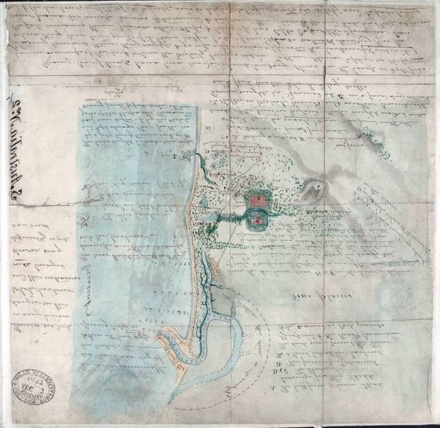
Rose Mitchell, From Roanoke to Aden: Colonial Maps in the National Archives of the United Kingdom   Page 2 of 17

      An important part of these archives are the records of the departments of state
responsible for colonial administration and for the foreign relations of England, Wales
and the United Kingdom since the sixteenth century, and there are many tens of
thousands of maps, plans and surveys of places overseas among these holdings. The
records are arranged by the government department which created or used them, not
according to theme, geographical area or publisher, and so it is useful for researchers
to have a broad awareness of the remit and timespan of these various offices. The
most important departments were those of the Secretaries of State (the State Paper
Office), the Board of Trade and Plantations, the Foreign Office, the Colonial Office,
the Commonwealth Relations Office, the Commonwealth Office, and now the Foreign
and Commonwealth Office (though the latter was created after the symposium end
date of 1950).

Early colonial period (late sixteenth century to c.1780)

      The first attempts to plant an English colony were made in the late sixteenth
century, when England set sights on America. TNA holds possibly the earliest
English map of part of North America based on direct observation, a map probably
made in 1585 and showing the location of the experimental colony of Roanoke
(Figure 1). Observations on the map give information useful to the prospective
coloniser, such as an abundance of fish and grapes.

      The Roanoke experiment failed, but this did not deter further English
settlements in America and the West Indies through the seventeenth and eighteenth
centuries. There was also trade and settlement in the East Indies and West Africa
from the mid eighteenth century, with slavery a major factor. In these early days of
English colonial empire, plantations (as colo nies were then termed) were regarded
mainly as sources of raw materials and labour. This link was reflected in the aims of
various committees set up to develop and govern the colonies under the aegis of the
Privy Council, culminating in the Board of Trade and Plantations (1700-1782). The
main focus of all these bodies was on the development of British commercial gains
from overseas colonies.

      This aim generated interest in geographical information, maps and surveys of
countries abroad. The Board appears to have taken an active role in acquiring this
information. In 1676 colonial governors were instructed to procure and send home
maps of territories for which they were responsible. The Board acquired manuscript
maps and plans, and purchased commercially printed maps. It also commissioned
surveys, such as those of de Brahms and Samuel Holland in North America. There
was interest in both overland routes and at sea, so charts were considered important,
as well as maps. Until the British Navy set up its own Hydrographic Office in 1795
captains were reliant upon commercially published charts.

      Colonial business generally declined after the loss of the American colonies,
following the American War of Independence, at which point the Board of Trade and
Plantations was abolished.

International Symposium on “Old Worlds-New Worlds”: The History of Colonial Cartography 1750-1950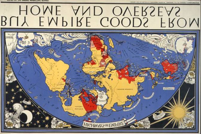
Rose Mitchell, From Roanoke to Aden: Colonial Maps in the National Archives of the United Kingdom Page 3 of 17
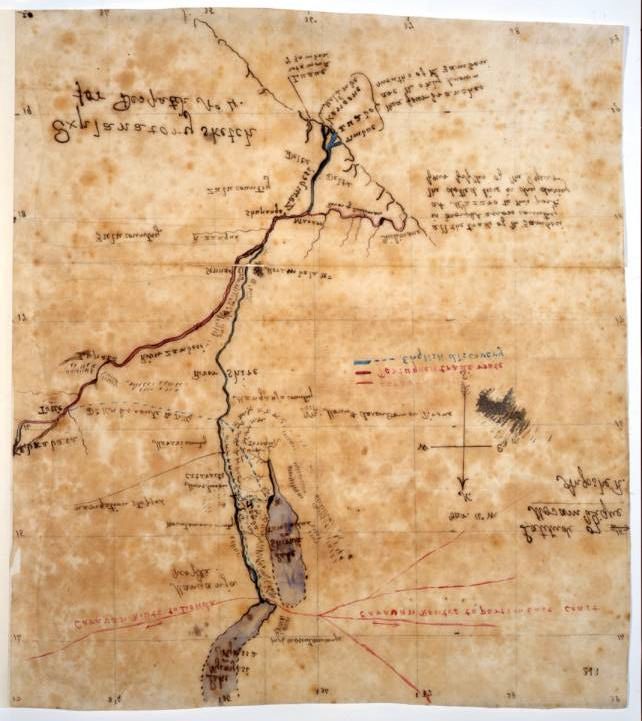
Figure 1. Map of the coast of North Carolina, made in about 1585, showing King's (now Roanoke) Island at
lower right, shortly to be settled as the first experimental English colony.2
While some maps and charts of the early colonial period are to be found among
the State Paper Office record series the majority, along with those of the Board of
Trade and Plantations, were subsequently inherited by the Colonial Office and
Foreign Office.
Main colonial period (c.1780 to c.1900)
Britain was at war with France for most of the period 1793 to 1815, motivated
on both sides to a large extent by trade and colonial ambitions. What colonial
business remained after the loss of the American colonies - largely that of the West
Indies and of the settlement of Australia - came under firstly the Home Secretary then
the War Secretary, until after the end of the Napoleonic wars. European conflict was
continued in the colonies of Britain and France overseas, and many Caribbean islands
changed hands during this period, some of them a number of times. This means that
2
The National Archives (hereafter TNA): Public Record Office (hereafter PRO): MPG 1/584 extracted
from CO 1/1. All images reproduced with permission from The National Archives.
International Symposium on “Old Worlds-New Worlds”: The History of Colonial Cartography 1750-1950Rose Mitchell, From Roanoke to Aden: Colonial Maps in the National Archives of the United Kingdom Page 4 of 17
TNA holds maps and other records of islands usually considered as part of the French
empire, for the periods when they were under British rule.
At the end of the wars there was rene wed interest in expansion of empire, for
example in what is now Canada. Colonisation by means of cheap land grants to
former soldiers was doubly attractive in that it provided a means of having ready-
trained militias if the United States of America were to try to invade and at the same
time it disposed of a post-war surplus unemployed population. Responsibility for
colonial affairs remained tied to military matters until the outbreak of the Crimean
War in 1854, when the overall volume of business required the War and Colonial
Department to be divided to form the War Office and the Colonial Office. The latter
body inherited maps acquired by its predecessors and these formed the beginning of
what became the Colonial Office Map Library. This collection burgeoned with the
deposit of mapping during the latter half of the century, now including that of Africa,
Asia, South America and New Zealand.
The Colonial Office was not the only major department involved in overseas
matters over the last few centuries. The Foreign Office, which came into being in
1782, was responsible for political relations with foreign powers included briefing the
Government on overseas affairs, enhancing British influence over other nations and
developing commercial links. Maps and pla ns often accompanied reports and
dispatches sent to the Foreign Office by diplomatic and consular officials. Many
others were acquired from mapsellers in order to assist comprehension of diplomatic
and territorial relations abroad. The War Office and the Admiralty were involved in
the business of overseas exploration and reconnaissance, and trained surveying
officers accompanied expeditions.
Each of the first three offices usually placed maps in the custody of
departmental libraries; their map libraries have been transferred to TNA (the
respective record series are listed in Table 1). These map libraries represent an ad hoc
accumulation and are rich sources of printed and manuscript maps. They consist of
maps inherited from earlier departments coupled with newly acquired maps. Many
maps were gathered by diplomats when abroad or by colonial governors and civil
servants, usually upon standing instruction from the Office concerned. A number of
maps were commissioned or purchased from mapsellers in the United Kingdom, to
ensure that cartographic information supplied to the Office was up to date. Officials
of all kinds might make or have maps made to illustrate their reports on official
matters.
The Hydrographic Office of the Admiralty from its inception in 1795 was
responsible for the collection and dissemination to the Royal Navy of hydrographic
information, principally by publication of Admiralty charts. To do this, surveys were
commissioned and charts made in an official capacity were collected to inform the
publication programme. The Historic Archive of the United Kingdom Hydrographic
Office is presently held at their office in Taunton, but it is proposed that it be
transferred to TNA over the next few years. This will complement the other records
of the Admiralty held at TNA, among which there is much overseas material, in the
International Symposium on “Old Worlds-New Worlds”: The History of Colonial Cartography 1750-1950Rose Mitchell, From Roanoke to Aden: Colonial Maps in the National Archives of the United Kingdom Page 5 of 17
form of views in ships’ logs such as those of Captain Cook, manuscript charting of
exploratory surveys and plans of dockyards and defences abroad 3 .
Table 1: Record series at The National Archives of interest for colonial cartography
research
(note: this lists the major sources and some others but is not comprehensive)
CO 700 Colonial Office Map Library Series I 1595 to 1927
CO 1045 Colonial Office Map Library Series II 1779 to 1947
CO 1054 Colonial Office Map Library Series III includes maps of the Colonial Office’s 1897 to1984
successors and some maps collected by the Foreign Office after 1940
FO 925 Foreign Office Map Library 1700 to 1940
WO 78 War Office Map Library
MPG 1 and MPGG 1 The extracted map series for Colonial Office records
MPH 1 and MPHH 1 The extracted map series for War Office records
MPI 1 and MPII 1 Dominions maps may be found in this general extract series
MPK 1 and MPKK 1 The extracted map series for Foreign Office records
MF 1 and MFQ 1 Series for extracted flat maps
MR 1 and MRQ 1 Series for extracted rolled maps
DO 35 General correspondence of the Dominions Office, among which maps may be found 1915-1971
DO 118 Material relating to treaties and agreements, amongst which maps may be found 1856 to 1965
DO 119 Maps of southern Africa can be found amongst correspondence of the High 1843 to 1965
Commissioners
Maps may also be found within original correspondence of the colonies concerned
eg for the Bahamas in CO 23, Hong Kong in CO 129 and Sierra Leone in CO 267.
Consult the online Catalogue to find the series for other colonies.
FO 302 Maps and plans of the North American Boundary Commission 1872-1876
CO 441 Plans acquired by the West Indian Incumbered Estates Commission 1770 to 1893
OD 6 Mapping of some of West Indies islands mapped under the Directorate of Overseas 1930s
Surveys
End of empire
The main government departments mentioned above continued to deal with
overseas affairs into the twentieth century, with changes in name and administrative
function, occasioned mainly by the world wars.
Britain continued to gain dependencies, notably in formerly German areas of
Africa mandated to Britain after the First World War, and in parts of the Middle East.
Other countries became British protectorates. In the late 1920s and early 1930s
Britain still saw herself as the centre of a vast empire of countries, interconnected by
strong communications and trade links, as shown by a poster commissioned by the
Empire Marketing Board at Figure 2.
3
Admiralty charts are widely scattered among the records at The National Archives, which does not
hold a discrete or comprehensive collection, in chart number order. The largest readily accessible
collection of published Admiralty Charts is held by the Map Library of the British Library and the
other legal deposit libraries: Cambridge University Library, the Bodleian Library, the library of Trinity
College Dublin, the National Libraries of Wales and Scotland
International Symposium on “Old Worlds-New Worlds”: The History of Colonial Cartography 1750-1950Rose Mitchell, From Roanoke to Aden: Colonial Maps in the National Archives of the United Kingdom Page 6 of 17
By the third decade of the twentieth century, however, there was also a
movement towards decolonisation. Some former colonies changed status to
dominions and some gained independence. The dominions were administered from
1907 by the Dominions Division of the Colonial Office until the formation of the
Dominions Office in 1925. There are significant quantities of maps and plans among
Dominions Office records, including those relating to treaties and agreements (see
Table 1).
Figure 2. ‘Highways of Empire’: a propaganda poster produced for the Empire Marketing Board in 1927 by
MacDonald Gill. The placing of the British Isles at the centre of the map emphasized Britain’s role as the
hub of the Empire. 4
Another new body was the Directorate of Overseas Surveys. Strictly speaking
this body, founded in 1946 as the Directorate of Colonial Surveys and part of the
Colonial Office, arises rather late on the scene to be of interest within the time
parameters of the symposium. It is worth mentioning here, because it was a late
flowering of a much earlier interest in colonial survey, and also because it has left a
substantial body of records which date back to the nineteenth century and are thus
well within the period now in view.
Systematic colonial surveys had been proposed as far back as the aftermath of
the Crimean War, when the War Office suggested that colonial surveys might be a
useful means of occupying military surveyors in peacetime. Disagreement between
the military and the Ordnance Survey over who should be responsible and other
4
TNA, Public Record Office, CO 956/537A.
International Symposium on “Old Worlds-New Worlds”: The History of Colonial Cartography 1750-1950Rose Mitchell, From Roanoke to Aden: Colonial Maps in the National Archives of the United Kingdom Page 7 of 17
demands meant that it was not until the Boer War and the lack of adequate mapping it
revealed that the call for colonial surveys was made again. The First World War and
ensuing economic difficulties meant that colonial surveying did not start as a
programme until the 1930s, and then was interrupted by the Second World War.
The Directorate of Overseas Survey remit was to set up national geodetic
frameworks and then provide mapping for colonies or increasingly for former
colonies. By this date, there was a strong role for aerial photographs in the making of
maps. The activities of this directorate built up a vast body of manuscript and
published maps, surveys, air photographs, and information about sixty countries and
their boundaries. Responsibility for overseas surveys passed to Ordnance Survey, and
its last incarnation Ordnance Survey International wound up in 2002. The Ordnance
Survey International Collection, as it is now known, was no longer required for
operational purposes and has been deposited at a number of institutions. The Royal
Geographical Society has a full set of maps produced by the Directorate of Overseas
Surveys and allied bodies; the Air Photograph Archive Library has gone to the new
British Empire and Commonwealth Museum at Bristol; and Cambridge University
Library and other bodies have taken remaining parts of the Collection. TNA will take
the International Boundary Archive, selected registered files and survey records, and
map production samples 5 .
MAPPING THE WORLD: FROM TROPICS TO ARCTIC WASTES
I have given above a broad history of the bodies within central government
responsible for the colonies. It is beyond the scope of this paper to give a breakdown
of the extent of the British empire across time or to give an account of each colony
and the mapping held for it at TNA. I can however make some general observations
on our holdings.
A vast area of the world is represented by maps among TNA. It is fair to say
that there are generally more maps for former colonies such as North America, the
West Indies and Australasia than there are for other areas. For example there are few
map for the Celebes, part of the Dutch empire, but many more maps for neighbouring
Borneo, because of British interest in the area via the British North Borneo Company.
Likewise in the Caribbean there are many maps for Jamaica, but few for the Dutch
colony of St Eustatius. There are hundreds of maps for Gibraltar dating from the
early eighteenth century, yet only a handful for the much larger Iceland for a few
decades in the twentieth century, since it was of much less strategic interest to Britain.
In addition to Gibraltar, there were other places in Europe which were British
colonies, even if some were so only briefly. Britain was one of a long succession of
masters of the Ionian islands until they were ceded to Greece in 1864, and there
remain maps from this period, and in particular plans of the fortifications built by the
British. Military maps also form a large part of TNA’ extensive holdings of maps of
Malta.
5
Information about the history, work and location of the records is on the Ordnance Survey website at
http://www.ordnancesurvey.co.uk/oswebsite/aboutus/international/collection
International Symposium on “Old Worlds-New Worlds”: The History of Colonial Cartography 1750-1950Rose Mitchell, From Roanoke to Aden: Colonial Maps in the National Archives of the United Kingdom Page 8 of 17
The wider foreign and military remit of the records means that TNA not only
holds maps of its own colonies and dominions, but also maps of other powers’
colonies. These might be acquired as commercially published maps, through
participation in international boundary commissions as a neutral party, by capture, and
from diplomats and military officers stationed abroad. As I indicated earlier, there
was also much exchange of some islands and countries between powers, and in these
cases it is possible that TNA may hold mapping for a country under Foreign Office or
War Office sources as well as Colonial Office ones, for different dates, as the country
was considered to change status from others’ colony to British, and vice versa. In
addition to the respective map libraries of these offices, maps may be found in their
respective series of correspondence relating to overseas countries. It is well to be
aware that records relating to a foreign power’s colony will be filed under that power,
not separately under the colony; for instance, maps and records for Martinique will be
found under the heading of France.
Those interested in the mapping of the period of British administration of India
and Burma, through the East India Company and later the India and Burma Offices
should note that this has not in the main passed to TNA. 6
While for some countries mapping may be sporadic or available only for a
certain time period, it is fair to point out that TNA does hold a wide range of types of
mapping for some countries from the time when they first became British colonies, if
not from before. My first example was taken from early North America, and the
holdings of mapping for the original states up to independence is particularly fine.
There are maps from the local level of land grants and plans of the original layout of
townships, charts of the coast and river navigation, to mapping of vast expanses for
exploration and international boundary purposes. In this case colonial mapping
ceased fairly early.
In the case of Australia there is a more comprehensive cartographic record.
TNA holds many maps of Australia. Perhaps the earliest are charts from Cook’s
voyages around Australasia in the 1760s and 1770s. Later maps show the developing
townscapes of Sydney, Melbourne, Perth and Adelaide (Figure 3).
Other maps show allotments of land beyond the towns, and there are also a
number of maps showing explorers’ routes, some of them published. There follow
geological maps, with the search for gold and other minerals. Then there are maps
showing aspects of colonial administration: postal and electoral districts, livestock
statistics, plans of the offices of colonial government, coaling stations for Naval and
merchant shipping.
The wealth of colonial mapping for Australia is mirrored for New Zealand, with
the additional genre of military mapping. The Maori Wars between 1845 and 1872
provided the impetus for military maps of great topographical detail. Thus much of
the early mapping of New Zealand is to be found in War Office map series. The
6
The India Office Records are public records administered by the British Library. They comprise the
archives of the East India Company (1600-1858), of the Board of Control or Board of Commissioners
for the Affairs of India (1784-1858), of the India Office (1858-1947), of the Burma Office (1937-
1948), and of a number of related British agencies overseas.
International Symposium on “Old Worlds-New Worlds”: The History of Colonial Cartography 1750-1950Rose Mitchell, From Roanoke to Aden: Colonial Maps in the National Archives of the United Kingdom Page 9 of 17
initial English settlement of New Zealand was made under the auspices of the New
Zealand Company, and TNA holds a number of the Company’s maps.
Figure 3 A manuscript map of the site of the city of Adelaide made in 1837 to illustrate the
suggested relocation of initial settlement from swampy ground on the coast to a better site inland and the
suitability of parts of the coast as harbours.7
On the question of colonial mapping, Australia and New Zealand are two cases
where there are examples of mapping from all the main phases of European
settlement: exploration, military reconnaissance, boundary definition, colonisation
and administration. Each colony followed its own timescale through these phases,
and for some countries there may be British mapping for only some of these phases.
For example a cache of seventeenth century defensive plans of Tangier date from the
7
TNA: PRO: CO 700 South Australia2
International Symposium on “Old Worlds-New Worlds”: The History of Colonial Cartography 1750-1950Rose Mitchell, From Roanoke to Aden: Colonial Maps in the National Archives of the United Kingdom Page 10 of 17
period when it came to England as part of Catherine of Braganza’s dowry on her
marriage to Charles II in 1661 but was then relinquished in 1668.
Exploration and military reconnaissance
These first two phases of overseas expansion often went hand- in-hand, and both
produced mapping as a record and as an aid to further expeditions. Exploratory
navigation was the province of the Royal Navy, which gave specific instructions in
the late eighteenth century to its captains such as Cook and Vancouver to explore and
chart the coasts of the far north-west of America and Australasia. In the 1820s and
1830s William Owen was given similar instructions to chart the east coast of Africa,
with an additional aim of assisting in the suppression of the slave trade there.
The English exploration of the interior of Africa was initially undertaken by
private individuals; Mungo Park’s first exploration had been made under the auspices
of a private society. However, Park’s account of this trip brought him to the attention
of the British government, and Park’s second journey to trace the course of the River
Niger 1805-1811 and subsequent major expeditions were government-funded 8 . There
are many manuscript maps of War Office provenance made as a result of military
survey from the early nineteenth century onwards, where the focus was on topography
and defensibility. TNA holds much mapping of the British colonies in Africa, in
particular of Southern Africa; some of this has been researched by members of the
ICA Working Group on the History of Colonial Cartography9 .
Boundary delimitation
Europeans took to the colonies notions of statehood which entailed the
delineation of international boundaries, especially where colonies of different powers
adjoined. The records of many international boundary commissions are in TNA and
are in some cases still used in settling disputes. The records in its custody contain
much information about mapping and surveying undertaken by or for British
government departments; they also shed light on mapping produced by overseas
governments and which the British government acquired for reference. As one might
expect, TNA holds maps produced for those boundary commissions on which Britain
was an active party, where a British colony was affected. However, maps for the
same boundary delimitation may also be held under Foreign Office references, where
they involved a colony of a foreign country. Thus in the case of the British Guiana
(Guyana)-Venezuela boundary for instance, TNA holds the manuscript Schomburgk
map which was the basis for many later maps of the boundary; atlases of maps
compiled by both countries for submission to arbitration in CO and FO series
respectively; and maps published but whose sale was prohibited abroad.
The archives include maps, surve ys and other records relating to international
boundaries in a much large number of areas of the world than one might expect. In
the nineteenth and early twentieth centuries particularly, British surveying expertise
8
Records of this expedition are in TNA: PRO: CO 2/2.
9
In particular Professor Elri Liebenburg, Dr Christopher Board and Mr Lindsay Braun
International Symposium on “Old Worlds-New Worlds”: The History of Colonial Cartography 1750-1950Rose Mitchell, From Roanoke to Aden: Colonial Maps in the National Archives of the United Kingdom Page 11 of 17
was universally respected, with the result that there was often a British commissioner
on international boundary commissions as a ‘neutral’ party even when Britain had no
direct colonial or commercial interest in the area surveyed. The job of these usually
military surveyors was to define and demarcate the boundary in question. It was
common practice for a certified copy of the boundary survey to be brought back to
London by the British commissioner and deposited among the archives (usually) of
the Foreign Office. As time has passed, archives in many countries have been
destroyed by war, natural disaster or political upheaval. As a result, documents now in
TNA may constitute the sole surviving record of earlier boundary surveys.
Colonisation and administration
Boundary definition at a more local level was important in these next phases of
settlement. TNA holds many maps which show how colonies were divided into
districts, in some cases taking into account information such as the location of tribal
areas. There are also many maps showing land grants and ownership.
Maps in TNA illustrate all phenomena and activities of interest to the colonial
administration. Communications were vital and there are many maps of colonial
railways and roads, also postal routes and offices. Geological maps were made with a
view to exploitation of coal, metals and diamonds. Other maps were made to show to
the governor types of produce and markets of his colony; and also the incidence of
tropical pests and diseases.
Achitectural drawings depict the sites and buildings that supported British
expansion overseas: fortifications, barracks, dockyards, hospitals, schools, prisons,
cemeteries and governors’ residences.
Types of map
There are topographical and cadastral maps, sea charts, triangulation and survey
diagrams. In terms of format, there is much unique manuscript material in TNA
which was made or collected by officers or civil servants in the course of their duties.
There are large holdings of commercial published mapping relating to matters such as
the division of Africa among European powers, and the exploration of Australia and
the North West Passage. In addition many manuscript maps considered important
were published by or for the War Office. The Colonial Office and Foreign Office
similarly issued important maps with accompanying despatches as Confidential
Prints. 10
One subject on which these offices collected and issued many maps and other
papers was that first of the Atlantic slave trade and later of attempts to suppress the
Indian Ocean slave trade. There are charts of the coast of Africa showing slave
caravan routes, ports and forts and sea routes for the slavers. There are also a number
10
Colonial Office confidential prints are in series by place: eg for Africa see CO 879; for Australia CO
881; and for West Indies CO 884. The Foreign Office confidential series are by country and are
numerous; there are also series for subjects such as the slave trade (FO 541) and opium (FO 415).
Much War Office confidentially printed material is in WO 33, including maps.
International Symposium on “Old Worlds-New Worlds”: The History of Colonial Cartography 1750-1950Rose Mitchell, From Roanoke to Aden: Colonial Maps in the National Archives of the United Kingdom Page 12 of 17
of maps of West Indian plantations which sometimes show slave quarters or
allotments of land to former slaves.
Colonial surveyors
While some colonial maps in TNA were commercially produced, many were
made specifically for the government to help it in its colonial business, like the one at
Figure 4. Many maps were made by people for whom this was not their main
occupation. Colonial governors, civil servants and diplomats stationed or travelling
abroad might turn their hand to making maps to illustrate a report on a particular
aspect of colonial administration or matter of interest such as the slave trade.
Some maps were made by professional cartographers. Once colonies were
established, it was common practice for surveyors to be appointed to carry our
mapping to assist the administration of the colony. While many of the finished maps
were sent back to the Colonial Office, the products of the day-to-day work of colonial
surveyors, such as notes, drawings or other survey documents, as with those of other
colonial administrators, were generally left behind in the colonies when colonial rule
ended. 11
The military also provided specially trained surveyors who undertook specific
work overseas. In the Army, the Royal Engineers (officers) and the Sappers and
Miners (other ranks) consistently provided the largest corps of military surveyors and
mapmakers. Surveying was often part of the training of a Royal Navy officer; TNA
holds charts made by Captain Cook, Nelson and Bligh, and many other naval officers
made as part of their official duties.
Military mapmaking was not confined to members of the specialist survey units,
and many other soldiers made maps in the course of their duties, whether to illustrate
reports and despatches, to record reconnaissance expeditions or to provide intelligence
to the War Office, the Admiralty, the Foreign Office or the Colonial Office. Military
attachés stationed at British embassies overseas would send to the Foreign Office
reports and maps relating to conflicts in areas where they were stationed. Many maps
were made by quite humble army officers, and include maps by men enlisted in native
regiments, not just those in the British army. These maps are thus a rich source of
information about a wide spectrum of people.
As well as minor figures, more famous men represented as mapmakers. TNA
holds a map made by Kitchener for the Khartoum relief expedition in 1884, 12 and
Mackenzie’s map of his exploration of the Mackenzie River in eastern Queensland
dated about 1795. 13 There is also a map made by David Livingstone to illustrate his
letter of October 1859 to the Foreign Secretary Lord Russell in which he described the
topography, local people and agriculture seen on his African travels. He referred
11
The National Archives does not generally hold domestic records of overseas governments, except in
a few cases such as Tangier and the Ionian Islands, for particular periods.
12
TNA: PRO: MPI 1/462/3
13
TNA: PRO: CO 700/America North and South54
International Symposium on “Old Worlds-New Worlds”: The History of Colonial Cartography 1750-1950Rose Mitchell, From Roanoke to Aden: Colonial Maps in the National Archives of the United Kingdom Page 13 of 17
dramatically to the area shown on the map: “no white man had ever traversed the
country before”. 14
How to find colonial maps in The National Archives
Looking for a map in TNA is a very different experience from using a map
library. Maps are arranged, like other records in the archives, not according to theme,
geographical area or publisher, but according to the government department which
created or acquired them. In addition to the map libraries of the Colonial Office,
Foreign Office and War Office mentioned above, TNA holds many maps scattered
through its holdings which may be of interest for research in colonial cartography.
Other government departments tended to acquire maps when they needed
geographical information or when a correspondent or informant sent or used a map,
perhaps to illustrate a report to the Admiralty about a voyage of exploration, or to
request funds from the Treasury to build a new government house.
The first place to begin a search for colonial mapping, or indeed any other kind
of record, is the TNA’s online Catalogue at
http://www.nationalarchives.gov.uk/searchthearchives
This Catalogue is keyword searchable, and descriptions of maps and plans are
gradually being added. There are two ways to consult this Catalogue. The search
facility allows a search by place, subject or person, perhaps adding the term ‘AND
map’. Alternatively, browse through the series lists in numerical order for example for
the map libraries of the Colonial Office the Foreign Office and the War Office (see
table 1 for details of these series). For detailed advice on searching the Catalogue see
the online Research Guide Using the National Archives to search for Maps, Plans and
Architectural Drawings (Domestic Records Information Leaflet 132).
Names of countries and places have not been expressed consistently over the
years. Entries in the Catalogue may use a variety of names and spellings: some are
contemporary with the records described; some were in use at the date of original
cataloguing - this may have been done many years ago, so that the place name as
given in the Catalogue is contemporary neither with the document nor with present-
day nomenclature. It is advisable, therefore, to search on a number of variants –
‘Bechuanaland’ and ‘Botswana’, for example, will produce different results. It is also
worth searching on more general terms such as ‘West Indies’, ‘East Indies’ etc.
In searching for combinations of places or particular aspects of places, it may be
necessary to make several searches and collate the results. This principle is well
illustrated by the records of the Colonial Office and the Foreign Office. To find a
map of the boundary between British Honduras and Guatemala, search for ‘Honduras
AND Guatemala AND boundary’. This will produce many hits, the majority of which
relate to records of the Foreign Office. These include not only maps specifically so
described but also volumes of original correspondence and confidential print, within
which it is very likely that there will be maps and plans which are not separately
described. In this case, none of the hits relating to records of the Colonial Office
mention maps and virtually none of the hits dates from before the middle of the
twentieth century. This is because the Colonial Office was more prone than the
14
TNA: PRO: FO 63/871
International Symposium on “Old Worlds-New Worlds”: The History of Colonial Cartography 1750-1950Rose Mitchell, From Roanoke to Aden: Colonial Maps in the National Archives of the United Kingdom Page 14 of 17
Foreign Office to focus only on the territories for which it was responsible. A search
using the terms ‘Honduras AND boundary’ and limited to CO will produce a very
different result.
Figure 5. Map drawn by Dr David Livingstone in 1859 to show English discoveries along the River
Shire, Lakes Shirwa and Nyassa, and the mouths of the River Zambesi. The area shown is now in Malawi
and Mozambique15 .
15
TNA: PRO: MPK 1/422/1 extracted from FO 63/871
International Symposium on “Old Worlds-New Worlds”: The History of Colonial Cartography 1750-1950Rose Mitchell, From Roanoke to Aden: Colonial Maps in the National Archives of the United Kingdom Page 15 of 17
Another useful leaflet is Maps and Plans: Overseas Relations (Overseas Records
Information 6)
http://www.nationalarchives.gov.uk/catalogue/RdLeaflet.asp?sLeafletID=64
Not all maps are yet described in the online Catalogue. There are published
map catalogues for the Americas, Africa and Europe (listed below) where
arrangement is by colony or country and by date, and these are still an important
source of information for colonial mapping. Beyond these sources, where it seems
likely that TNA will hold mapping you seek, you may need to visit and carry out a
search for example among Colonial Office correspondence for the country concerned,
or use a card index and other hard copy finding aids on-site.
While some maps may readily be found by descrip tion in the online and other
catalogues, it is known that many thousands of maps remain unidentified and
uncatalogued among the records. The majority of the maps which are now in TNA
were transferred together with the letters, reports, registered files or other documents
with which they were originally associated in the course of official business. If you
are looking for a particular map which does not appear to be described in any of the
catalogues, a certain amount of lateral thinking may be necessary; ask yourself which
government department is likely to have made, used or acquired the kind of map you
wish to find. It will be necessary to make a search for relevant documents, among
which maps may lie.
The descriptions represent but a fraction of the material still to be found within
these records, making it a potentially fruitful field for research. This is particularly
true for areas of the world for which catalogues have not been published: in particular
Australasia, of which TNA holds many maps, and Asia.
When searching, remember that the Catalogue and other wider finding aids of
TNA were compiled from the wider perspective of the whole archives. It is only in
the case of the published map catalogues and research guides specifically on maps
that one can assume a priori that the item described is a map.
One benefit of the union catalogue is that it makes it easier to find non-
cartographic items related to a search for maps of a particular colony or area. TNA
holds much material about the process of surveying and mapping. This may not just
be the maps, also photographs, survey diagrams and other survey records, and also the
policy files containing papers directing such surveys. There are ships’ and captains’
logs, and instructions for surveys such as George Vancouver’s instructions from the
Admiralty to survey the north west coast of America and despatches from him to the
Colonial Office while making this epic survey, 1791-1793.16 There are also requests
by surveyors for loan of instruments and claims for expenses, which can throw light
on the survey work. The Catalogue includes descriptions of reports and policy files
relating to surveys, survey diagrams, and photographs (Figure 6).
16
TNA: PRO: CO 5/187 (Vancouver). For logs see the series lists for ADM 51, ADM 53 and ADM
55.
International Symposium on “Old Worlds-New Worlds”: The History of Colonial Cartography 1750-1950Rose Mitchell, From Roanoke to Aden: Colonial Maps in the National Archives of the United Kingdom Page 16 of 17
Figure 6. This photograph is one of a series recording the work of the North West Boundary
Commission working on the demarcation of the boundary between the United States and Canada between
1872 and 1878. 17
REFERENCES
http://www.nationalarchives.gov.uk
PA Penfold, ed, Maps and Plans in the Public Record Office: 2 America and West
Indies (London, 1974)
PA Penfold, ed, Maps and Plans in the Public Record Office: 3 Africa (London 1982)
Geraldine Beech, ed, Maps and Plans in the Public Record Office: 4 Europe and
Turkey (London 1998)
Michael Roper, The Records of the Foreign Office 1782-1968, Public Record Office
Handbooks No.33 (Public Record Office 2002)
17
TNA: PRO: FO 302/30. Maps made by the survey parties are also in FO 302.
International Symposium on “Old Worlds-New Worlds”: The History of Colonial Cartography 1750-1950Rose Mitchell, From Roanoke to Aden: Colonial Maps in the National Archives of the United Kingdom Page 17 of 17
Anne Thurston, Sources for Colonial Studies in the Public Record Office Vol. 1.
Records of the Colonial Office, Dominions Office, Commonwealth Relations
Office and Commonwealth Office (HMSO, 1995)
Alistair Macdonald, Mapping the World, a history of the Directorate of Overseas
Surveys, (HMSO, 1996)
International Symposium on “Old Worlds-New Worlds”: The History of Colonial Cartography 1750-1950You can also read