A DATA CAPTURE FRAMEWORK FOR IMPROVING THE QUALITY OF SUBSURFACE UTILITY INFORMATION
←
→
Page content transcription
If your browser does not render page correctly, please read the page content below
The International Archives of the Photogrammetry, Remote Sensing and Spatial Information Sciences, Volume XLII-4/W15, 2019
                                      14th 3D GeoInfo Conference, 24–27 September 2019, Singapore

            A DATA CAPTURE FRAMEWORK FOR IMPROVING THE QUALITY OF
                        SUBSURFACE UTILITY INFORMATION

                                                R. van Son 1, Jaw S.W. 1,2,3, A. Wieser 4
                             1
                               Singapore-ETH Centre, ETH Zürich, Singapore - (vanson, jaw)@arch.ethz.ch
  2
      Geoscience & Digital Earth Centre (INSTeG), Research Institute for Sustainable Environment, Universiti Teknologi Malaysia,
                                                     Malaysia – swjaw@utm.my
         3
           Department of Geoinformation, Faculty of Geoinformation & Real Estate, Universiti Teknologi Malaysia, Malaysia
             4
               Institute of Geodesy and Photogrammetry, ETH Zürich, Switzerland - andreas.wieser@geod.baug.ethz.ch

                                                      Commission VI, WG VI/10

KEY WORDS: Underground Utility Mapping, 3D Mapping, Digital Twin

ABSTRACT:

To plan, develop, and manage underground space and make informed decisions leading to desirable outcomes, planners, land
administrators, and engineers need to make sense of the underground. A reliable digital twin of the underground - a realistic, digital
representation of the physical world below the surface - is required. Utilities, consisting of the pipes, ducts, cables, manholes and other
assets that provide electricity, gas, water, sewerage, and telecommunication services, make up a significant portion of the shallow
layers of the subsurface. A lack of reliable information on subsurface utilities may potentially lead to poor decisions leading to
undesirable outcomes, lengthy and costly planning and land administration processes, and lengthy, costly, and hazardous development
processes. The advent of mobile 3D ground penetrating radar technology offers the promise of non-destructive mapping of existing
subsurface utilities in a large area in a relatively short amount of time and could potentially be used to improve the reliability of
available information. In this work, a small number of cases studies are described at evaluating the feasibility of a large area mapping
approach for subsurface utilities. Based on the results of the studies, a data capture framework for the gradual improvement of the
quality of information on existing subsurface utilities is proposed.

                      1. INTRODUCTION                                   data capture can be considered fast, the processing of that data is
                                                                        still a laborious effort that will likely result in valuable
In March 2019, the Urban Redevelopment Authority of                     information.
Singapore unveiled its Draft Master Plan 2019 to guide
Singapore's development for the next 10 to 15 years (Urban              The results of the case studies serve as key discussion points on
Redevelopment Authority, 2019). The use of underground space            the feasibility of large area subsurface utility mapping projects -
is one of its strategies to create space for the land-scarce city-      possibly to be scaled up to a nation-wide mapping approach,
state's growing needs. A large number of underground                    similar to national mapping projects already in place for above
developments are already in place, in progress, or in place. As a       the surface. Based on this, a data capture framework for the
consequence, Singapore's underground space is becoming more             reconciliation of the quality of information on existing subsurface
and more congested, and the development and use of                      utilities is proposed that operates on the principle of a piecemeal,
underground space is becoming an increasingly challenging task.         gradual improvement of information quality instead of a single,
A reliable digital representation of the underground is required to     nation-wide effort. It is recommended that such a framework
enable professionals to make informed decisions.                        capitalizes on opportunities where a clear and proven business
                                                                        case for a non-destructive mapping approach exists.
The Digital Underground project addresses the lack of a reliable        Additionally, it is recommended that the limited opportunities
map of subsurface utilities for planning and land administration        that provide an unobstructed line of sight and accessibility to
in Singapore and aims to develop a roadmap towards more                 subsurface utilities are used to capture data using conventional
accurate, current, and complete information. Recent industry            and alternative surveying techniques.
developments towards the use of ground penetrating radar
technology for subsurface utility mapping offer a compelling and
promising case for government agencies and utility owners. In                   2. THE NEED FOR A RELIABLE MAP OF
this work, we describe the activities conducted by the project to                     SUBSURFACE UTILITIES
assess the feasibility of mobile 3D ground penetrating radar
technology to map subsurface utilities for large areas in a single,     To plan, develop, and manage underground space and make
concerted effort.                                                       informed decisions leading to desirable outcomes, planners, land
                                                                        administrators, and engineers need to make sense of the
In October 2018, a number of case studies were conducted,               underground. A reliable digital twin of the underground - a
collecting data in 9 areas in Singapore. These data were                realistic, digital representation of the physical world below the
processed to detect and locate subsurface utilities. The results        surface - is required. Utilities, consisting of the pipes, ducts,
were compared to available map data on existing subsurface              cables, manholes and other assets that provide electricity, gas,
utilities. Also, the practical operation of the platform was            water, sewerage, and telecommunication services, make up a
evaluated. From these results, it can be concluded that, while raw      significant portion of the shallow layers of the subsurface.

                                                  This contribution has been peer-reviewed.
                     https://doi.org/10.5194/isprs-archives-XLII-4-W15-97-2019 | © Authors 2019. CC BY 4.0 License.                      97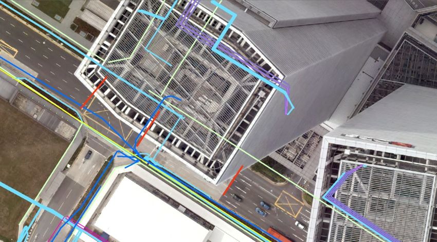
The International Archives of the Photogrammetry, Remote Sensing and Spatial Information Sciences, Volume XLII-4/W15, 2019
                                   14th 3D GeoInfo Conference, 24–27 September 2019, Singapore

                                                                       In a workshop conducted in October 2018, representatives from
Having unreliable information of underground utilities may             various land administration departments within Singapore Land
potentially result in (i) not well-informed planning decisions         Authority shared their perspective on the value of a reliable map.
upfront, resulting in lengthy planning and development                 The results are summarized in Table 1.
processes, risky configurations of underground assets, and a loss
of opportunity for future uses of space, (ii) inefficient and costly   2.3 Underground construction and excavation works
land administration processes all throughout the life cycle of the
land, and (iii) additional utility locating costs, delays, safety      Any construction project that involves excavation requires efforts
hazards, and loss of services due to utility strikes during            to locate existing utilities prior to construction. The availability
excavation works.                                                      of reliable information can lead to various cost reductions. This
                                                                       value is well known and documented for cases in Ontario and the
2.1 Urban planning                                                     United States (Osman & El-Diraby, 2005, and Zembillas & Scott,
                                                                       2010). In this section, a few examples are highlighted to
Urban planners working for land development agencies in                underline the importance of reliable subsurface utility
Singapore need reliable information on subsurface utilities for the    information for underground construction works.
planning and safeguarding of underground space for future use.
Utility information is required to ensure the following outcomes:      2.3.1 Utility locating prior to excavation: The value of
(i) to plan for the future use of underground space, (ii) to           reliable information for the purpose of locating existing utilities
safeguard underground space for future use during development          prior to excavation can be supported by a few notable examples.
and approval of plans for underground development incl. utilities,     For the Sydney Light Rail Extension Project, significant work
and (iii) to ensure minimum clearance from existing underground        was performed to collect available map data of existing
assets during development and approval of plans for underground        underground utilities prior to awarding the contract for
development incl. utilities.                                           construction. The available information often turned out to be
                                                                       unreliable and, additionally, many more unknown utility services
The best-case scenario for planners is to plan for underground         were encountered during construction. Eventually, it was
space upfront. To do so, in particular with an already congested       estimated that the availability of reliable and complete
underground space, reliable information on subsurface utilities is     information would have resulted in project completion one and a
of the essence. Conversely, the lack of a reliable map can have        half years earlier, a severe cost reduction, and lower risk for
far-reaching effects. Poor as-built records of subsurface utilities    construction workers involved (Zeiss, 2019).
can lead to a planned utility layout not being available, typically
resulting in the nearest available (non-planned) path being used,      In the United States, construction projects are understood to
which may not be recorded accurately. As such, unreliable              inflate bids by an estimated 10-30% in order to accommodate risk
information leads to additional cost and duration for utility          associated with unknown or poorly mapped utilities. Conversely,
installation. Even more so, it can lead to unpredictable and           an estimated USD 10M was saved during the I-20/I-59 Corridor
unknown layouts that can negatively impact any future utility          project in Alabama by capturing and sharing information in
installation or other underground developments, limiting the           advance to all contractors involved. Existing records were
ability for future services to be constructed and impeding             combined with ground penetrating radar scans, electromagnetic
construction of other infrastructure underground.                      locator readings and trial trenches to develop a reliable, 3D map
                                                                       (Zeiss, 2019).
As such, the lack of a reliable map can potentially lead to (i)
planning being more complicated, lengthy, and costly than              2.3.2 The cost of utility strikes during excavation: A lack of
necessary, (ii) utility installation being more lengthy and costly     reliable information on subsurface utilities increases the risk of
than anticipated, (iii) situations that can potentially affect the     utility strikes during underground construction and excavation
safety and resilience of existing underground infrastructure, and      work. Utility strikes can result in damage to the pipe or cable that
(iv) the loss of opportunity for future underground space use.         was hit. Even more so, it has indirect and social costs, including
                                                                       traffic disruption, injuries, and loss of business. Makana et al.
2.2 Land administration                                                (2016) estimate the indirect and social cost to be 29 times the
                                                                       direct cost of the utility strike for cases studied in the United
In Singapore, a large portion of land is owned by the state. State     Kingdom.
land is actively managed by the various land development
agencies of Singapore. The administration of state land                In the Netherlands, around 33,000 utility strikes were reported in
comprises a range of processes to administer, including land           2017. The total associated cost was estimated to be EUR 25.2M
ownership and conflict management, taxation, land acquisition,         (Agentschap Telecom, 2018).
land lease, land use planning, land development, and land sales.
                                                                       In Singapore, the number of reported utility strikes is unknown.
 Life cycle phase      Value of reliable information                   In (Tham, 2019) it is mentioned that "Singapore has suffered 26
 Land acquisition      Land valuation. Assessment of                   cases of telecommunication cable cuts in the past three years that
 and purchase          encumbrances below the surface.                 resulted in hours or days of Internet and telephony service
 Land rejuvenation     Assessment and location of subsurface           outages". The Energy Market Authority mentions "a fine not
                       encumbrances to be removed.                     exceeding $1 million or imprisonment for a term not exceeding
 Planning and          Development and evaluation of plans             five years, or both" as the penalty for earthworks contractors
 coordination          for underground development.                    accompanied by a list of over 40 convicted earthworks
 Interim land use      Facilitation of interim land use plans.         contractors since 2013 (Energy Market Authority, 2019).
 Land transfer and     Provision of correct and complete
 sales                 information on land for sale.
 Table 1. Value of reliable information for land administration
                            purposes

                                                 This contribution has been peer-reviewed.
                    https://doi.org/10.5194/isprs-archives-XLII-4-W15-97-2019 | © Authors 2019. CC BY 4.0 License.                      98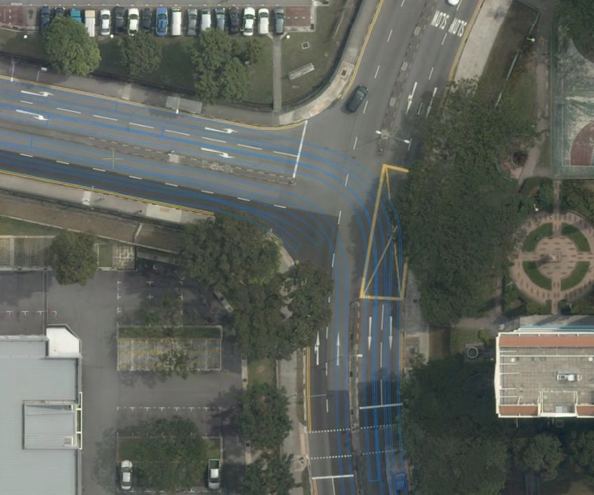
The International Archives of the Photogrammetry, Remote Sensing and Spatial Information Sciences, Volume XLII-4/W15, 2019
                                   14th 3D GeoInfo Conference, 24–27 September 2019, Singapore

2.4 Reliability as the product of quality                              However, these opportunities are not always available and the
                                                                       lack of accuracy of information on existing, buried subsurface
A digital twin, map, or spatial dataset is reliable when it can be     utilities remains to be reconciled. Exposing existing buried
trusted and depended on consistently for a specific application or     utilities and re-surveying them in order to improve quality is not
task. The described work operates on the premise that a sufficient     feasible as it would be complicated, costly, and often leading to
degree of quality of subsurface utility information is required for    significant disruptions to road traffic. Other opportunities, such
planning, land administration, and underground development             as digging trial trenches prior to excavation or pipeline repairs
work applications. Based on workshops and interviews                   are sparse, spatially limited, and offer a very short time window.
conducted with potential end users, the following aspects were
identified as most significant with respect to information quality:    3.1 The use of ground penetrating radar for mapping buried
                                                                       subsurface utilities
     Spatial accuracy, i.e. the degree of closeness to which
     geographical positions and dimensions match the real world        In recent years, techniques for subsurface utility mapping that no
     Currency, i.e. the degree to which data is up to date and         longer require an underground asset to be exposed, such as
     reflects the current state of the real world.                     ground penetrating radar, have become commercially available
     Completeness, i.e. the degree of absence of gaps between          at a large scale.
     spatial objects that are represented in the available data and
     what really exists in the real world.                             Ground penetrating radar (GPR) is one of the most commonly
                                                                       used technologies for the detection and mapping of utilities
An analysis of available data and experiences from its users leads     buried underground (Lai et al., 2018). The GPR antenna transmits
to the conclusion that the current degree of quality is generally      electromagnetic signals into the ground and records the signals
considered insufficient. Available subsurface utility information      that are reflected on the ground surface when it encounters buried
is often inaccurate or of unknown accuracy. Reasons for this           objects. Off the shelf ground penetrating radar systems are
include the use of a cartography-centric approach to data              typically incorporated into a small trolley that can be pushed over
(re)presentation, a lack of (accurate) surveying in the past, no       the target area.
efforts to improve the quality of information, and the lack of
depth or elevation information.                                        So-called multichannel 3D GPR array systems (Novo et al.,
                                                                       2013) have become commercially available in recent years.
2.5 Digital Underground: Towards a reliable map                        These array systems consist of a large number of closely-spaced
                                                                       antennas, enabling them to produce high-resolution 3D
The Digital Underground project is an initiative of the Singapore      radargrams in a relatively small amount of time. These systems
Land Authority and the Singapore-ETH Centre. The main                  can be mounted on or towed by regular road-based vehicles. This
objective of the project is to develop a roadmap, outlining the        offers the potential of capturing large volumes of data in a
actions and milestones that ultimately lead to the establishment       relatively small amount of time, while at the same time
and sustenance of a reliable map of subsurface utilities in            minimizing traffic disruptions.
Singapore.
                                                                       Underlining the growing need, use, and acceptance of ground
Among other subjects, Digital Underground's research activities        penetrating radar as a utility mapping technique, a small but
focus on the question how non-destructive surveying and                growing number of countries and cities have introduced
mapping techniques - in particular ground penetrating radar - can      standards that aim to formalize and standardize practices of and
be used to improve the quality of subsurface utility information       surrounding mapping newly built and existing buried subsurface
in Singapore.                                                          utilities. These standards incorporate and endorse the use of
                                                                       ground penetrating radar, often along with the use of
                                                                       electromagnetic location techniques. These include the United
  3. TECHNIQUES FOR SURVEYING AND MAPPING                              States, Canada, the United Kingdom, Malaysia, Australia, and
            SUBSURFACE UTILITIES                                       Hong Kong.
In (Van Son et al., 2018) a comprehensive overview of
techniques for surveying and mapping of subsurface utilities is                       4. CASE STUDY APPROACH
described that includes conventional surveying techniques, point
cloud-based techniques, geophysical techniques, and gyroscopic         A case study was conducted to assess the feasibility and benefit
mapping.                                                               of the use of 3D ground penetrating radar technology for
                                                                       subsurface utility mapping.
In Singapore, from 2017 onwards, utility laying contractors have
been mandated to provide accurate, 3D as-built records of all          4.1 Case study objectives
newly built utilities according to the Standard and Specifications
for Utility Survey in Singapore (Singapore Land Authority,             The objectives of the case studies with 3D GPR were to (i) assess
2017). The standard currently endorses the use of total station,       the practical feasibility of operating a 3D GPR mobile mapping
GNSS Real Time Kinematic, and 3D laser scanning as suitable            platform on the streets of Singapore and (ii) assess the feasibility
techniques for surveying utilities. In practice, conventional          and viability of large volume, large area data subsurface capture
surveying techniques are used almost exclusively and laser             to improve the quality of existing utilities.
scanning is currently not extensively adopted by utility surveyors
in Singapore.                                                          4.2 Data capture locations

All of the endorsed techniques require an unobstructed line of         Nine study areas were selected in different areas of Singapore.
sight and access to the newly built asset as well as sufficient time   The selection includes a “virgin” practice area (near the future
to conduct a proper survey before backfilling of the soil occurs.      Canberra MRT station), relatively new residential estates

                                                 This contribution has been peer-reviewed.
                    https://doi.org/10.5194/isprs-archives-XLII-4-W15-97-2019 | © Authors 2019. CC BY 4.0 License.                      99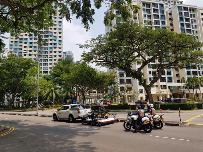
The International Archives of the Photogrammetry, Remote Sensing and Spatial Information Sciences, Volume XLII-4/W15, 2019
                                   14th 3D GeoInfo Conference, 24–27 September 2019, Singapore

(Punggol and Sengkang), relatively old residential estates (Ang
Mo Kio and Toa Payoh), parts of the central business district
(Raffles Boulevard and Marina Boulevard), an industrial estate
(Woodlands Spectrum), and the University Town campus of the
National University of Singapore. With the selection of different
areas, it was attempted to investigate different subsurface
contexts, e.g. different soil conditions, different utility layouts,
and changes due to the progression of the sub-surface over time.

4.3 Technology used for data capture

The Leica Pegasus:Stream mobile mapping platform was
deployed at the selected study sites. The Pegasus: Stream
combines a Stream EM GPR array with a Leica Pegasus Two
photo and laser scanner. It is an integrated hardware solution for
3D mapping of the above ground and the underground. The large
GPR array consisting of 40 antennae transmitting and receiving               Figure 2. Blue lines indicate the outlines of multiple
in two distinct polarisations allows for the collection of data for               overlapping scan tracks for a single road.
swaths of surface at a time. Simultaneously, the system can
capture calibrated imagery and point clouds of above ground
                                                                       4.5 Data processing
features. All the data captured by the Pegasus: Stream was geo-
referenced using a combination of on-board sensors that include        All acquired data were pre-processed to enhance the quality of
a GNSS receiver, an Inertial Measurement Unit (IMU), and a             the radargram before further interpretation. After that, post-
Distance Measurement Instrument (DMI).                                 processing of the captured data was conducted in order to
                                                                       interpret the data and detect, locate, and extract subsurface
4.4 Practical operation                                                utilities from the captured data. After that, the data was exported
                                                                       to CAD and GIS formats for further 3D modelling and
The platform was towed behind a vehicle moving at a speed of
                                                                       visualization. For post-processing, the GRED HD 3D CAD
not exceeding 15km/h. This means it can theoretically cover and
                                                                       software package was used. The post-processing was conducted
capture data of over tens of hectares per day. The potential of
                                                                       by a specialized ground penetrating radar data analyst with over
large-area data capture without interruption of traffic flows can
                                                                       5 years of GPR processing experience.
reduce cost and time for mapping significantly. Despite this and
due to the slow speed of movement and lack of safety features on
                                                                       4.6 Data comparison
the platform itself, auxiliary police escorting services were hired.
A special purpose license was acquired from the Land Transport         To assess the quality of data captured from each site, the captured
Authority of Singapore to allow the platform on the roads of the       data was compared to available 2D map data provided by various
selected case study areas only. To enable the capture of above         utility owners in Singapore through the GeoSpace platform. The
ground data using the on-board laser scanner, data was captured        comparison was conducted based on basic visual cues such as
in daylight conditions.                                                proximity, overlap, and geometric similarity of features. No
                                                                       further verification of the extracted results was conducted.

                                                                                                5. RESULTS

                                                                       Due to an unanticipated amount of time required for post-
                                                                       processing and comparison of the data, the captured data of only
                                                                       three areas were eventually post-processed and analysed for
                                                                       comparison with available map data. These areas were in (i) Toa
                                                                       Payoh and (ii) Ang Mo Kio, two relatively old residential estates
                                                                       in Singapore containing many developments from the 1960s and
                                                                       1970s, and (iii) Marina Boulevard, a commercial district in
                                                                       Singapore's Central Business District area, built on recently
                                                                       reclaimed land featuring many developments in the 2010s.

        Figure 1. Data capture in Toa Payoh, Singapore.                5.1 Toa Payoh
For a single scan, the Stream EM can cover a swath of 1.75m in         The main scanning route in Toa Payoh was a bi-directional loop
width. In Singapore, road lane width is often 3.2m or wider.           around the selected area. The total length for one loop is about
Therefore, two scan tracks are typically required to cover a single    1.8km. All roads consist of 4 lanes (2 lanes for each carriageway).
lane and multiple passes of the same road were required to cover
the entire surface of the road (Figure 2). The platform was only       The scanning at Toa Payoh proved to be challenging due to local
used on the surface of the road and not on the adjoining side table.   traffic conditions and took a longer time to complete as compared
                                                                       to newer residential estates such as Punggol or Sengkang. The
                                                                       total time need for the scanning at Toa Payoh is 5-6 hours while
                                                                       the scanning at Punggol or Sengkang was about 3.5 hours.

                                                 This contribution has been peer-reviewed.
                    https://doi.org/10.5194/isprs-archives-XLII-4-W15-97-2019 | © Authors 2019. CC BY 4.0 License.                    100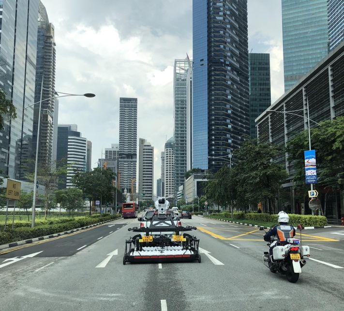
The International Archives of the Photogrammetry, Remote Sensing and Spatial Information Sciences, Volume XLII-4/W15, 2019
                                   14th 3D GeoInfo Conference, 24–27 September 2019, Singapore

An excerpt near the northwest corner of the scanning area is              5.2 Ang Mo Kio
highlighted in greater detail. Figures 3 and 4 display the available
map data and the extracted utilities, respectively. As indicated by       The main scanning route in Ang Mo Kio is a bi-directional loop
available map data, 4 utilities run parallel to the road direction.       around the selected area. The total length for one loop is about
There are also 4 utilities detected by GPR for that same road.            1.75km. All roads consist of 4 lanes (2 lanes in each
However, the alignment of the utilities detected is different from        carriageway). 2 bus lanes run along the sides of one of the roads.
the available map data, except for those utilities that are at the left
and right side of both carriageways. The alignment of the utilities       For detailed evaluation, an excerpt is assessed in greater detail.
extracted from the GPR data at the centre of the carriageway and          Figures 5 and 6 display the available map data and the extracted
on the left lane match the available data very well.                      utilities, respectively.

Figure 3. Available map data on existing utilities in highlighted
                      area, Toa Payoh.

                                                                          Figure 5. Available map data on existing utilities in highlighted
                                                                                               area, Ang Mo Kio.

 Figure 4. Extracted utilities (red lines) in highlighted area, Toa
                              Payoh.
According to available map data, one utility and two drain lines
and ducts cross the road. Five utilities were detected by the GPR.
Only one utility on the left matches the available data. Other
utilities are either not mapped accurately or not present in the
available data. As the type and size of the utility assets can't be
extracted from radar data alone unless further processing and
                                                                          Figure 6. Extracted utilities (red lines) in highlighted area, Ang
additional data capture are performed, it is not possible to assess
this difference in further detail. Further verification, such as trial                                 Mo Kio.
pit measurements, are required to verify these detection results.         At the northern part of the road, seven utilities are running
                                                                          parallel to the road as indicated by available map data. However,
                                                                          only four utilities can be detected by the GPR. Reasons for not
                                                                          being able to detect all utilities are most likely the fact that they
                                                                          are buried very near to one another, making it challenging for the

                                                 This contribution has been peer-reviewed.
                    https://doi.org/10.5194/isprs-archives-XLII-4-W15-97-2019 | © Authors 2019. CC BY 4.0 License.                        101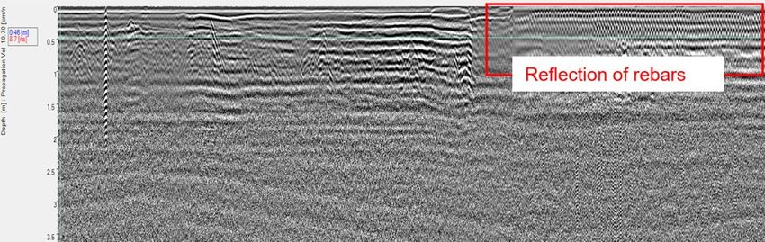
The International Archives of the Photogrammetry, Remote Sensing and Spatial Information Sciences, Volume XLII-4/W15, 2019
                                   14th 3D GeoInfo Conference, 24–27 September 2019, Singapore

analyst to detect and extract those utilities, as well as the grouping
of various cables that are indicated as individual features on the
map into single ducts.

At the southern part of the same road, several low voltage cables
and two pipes run across the road as indicated by GeoSpace data.
Four utilities were detected by the GPR. From the comparison, it
is likely that two unmapped or unknown utilities have been found
in addition to the ones recorded in the available map data.

5.3 Marina Boulevard

The main scanning route in Marina Boulevard is a rectangular,
clockwise loop with a length of about 1.2km. The scanning                   Figure 8. Available map data (non-red lines) and extracted
started and ended at the unloading site. Two of the main roads in           utilities (red lines) in highlighted area, Marina Boulevard.
this loop consist of five lanes, while the other two roads consist
of two lanes. The scanning at Marina Boulevard proved to be
fairly straightforward due to an unanticipated nearby car-free
Sunday event resulting in a decrease in traffic intensity at the
location. Due to the five-lane width of the main roads a large
number of scanning passes (nine) had to be conducted. Scanning
had to be halted several times due to bad weather conditions
during the scanning.
                                                                          Figure 9. Concrete slab and rebar mesh affecting data quality
                                                                                     and interpretation in Marina Boulevard.

                                                                                              6. CONCLUSIONS

                                                                         Over the course of six days, various datasets were captured for
                                                                         large areas in Singapore using a mobile 3D ground penetrating
                                                                         radar platform. Three of those datasets were processed further to
                                                                         extract subsurface utilities and compare the results with available
                                                                         map data.

                                                                         6.1 Quality of available map data

                                                                         Although no verification of captured data or available map data
                                                                         has been conducted, the results lead to various conclusions
  Figure 7. Scanning in between two lanes on a five-lane road,           regarding the quality of existing available map data. The lack of
                      Marina Boulevard.                                  exact matches between captured and available data underline the
                                                                         need to improve the reliability of subsurface utility map data in
For detailed evaluation, an excerpt of the area is assessed in
                                                                         Singapore.
greater detail. Figure 8 displays the available map data and the
extracted utilities. According to the map data, there are one cable
                                                                         Although it is not possible to determine the exact cause of these
duct and one low voltage cable crossing the road. Three utilities
                                                                         mismatches, a lack of accuracy and an undefined measure of
were detected by the GPR. As highlighted in the figure, only one
                                                                         (in)accuracy of data are observed in available data. Some of these
detected utility matches the map data. Other utilities were newly
                                                                         are likely to be caused by proprietary data representation, e.g.
found in the GPR data. The low voltage cable was installed under
                                                                         representing various cables contained in a single duct as
a rigid pavement, where a concrete slab and the steel in the form
                                                                         individual features on a map for cartographic purposes. Various
of bars or mesh (so-called rebar) were used as a reinforcement.
                                                                         subsurface utilities were detected that did not appear to have a
This limited the penetration of the radar signal (Figure 9). From
                                                                         match in available data. For older areas of Singapore, these could
available map data, it appears that most of the utilities are
                                                                         indicate the presence of old, "legacy" utilities, underlining the
installed under the side table of the road. To cover these areas, a
                                                                         need for a complete map. For newer areas, these detected utilities
trolley-based system is required.
                                                                         may instead be relatively new, underlining the need for a more
                                                                         current, up to date map of subsurface utilities.

                                                                         6.2 Data capture

                                                                         Data was captured for each area in less than half a working day.
                                                                         Despite the relatively low travel speed (15 km/h), the platform
                                                                         operated in regular traffic conditions without any notable issues.
                                                                         With 3D GPR data capture speeds expected to increase in the
                                                                         near future (Impulse Radar, 2018), the towing vehicle will be able
                                                                         to participate in traffic normally, removing the need for special
                                                                         safety measures. Although data capture was conducted in
                                                                         daylight conditions to capture above ground photo imagery along

                                                 This contribution has been peer-reviewed.
                    https://doi.org/10.5194/isprs-archives-XLII-4-W15-97-2019 | © Authors 2019. CC BY 4.0 License.                     102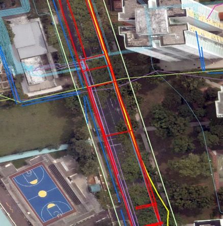
The International Archives of the Photogrammetry, Remote Sensing and Spatial Information Sciences, Volume XLII-4/W15, 2019
                                   14th 3D GeoInfo Conference, 24–27 September 2019, Singapore

with subsurface radar data, subsurface data capture alone can be         potential areas for improvement. In particular, while data capture
conducted at any time of the day or night and allow for capture          is rapid, data processing isn't. Therefore, it is recommended to
in relatively easy conditions and circumstances.                         investigate the possibilities for increasing the economic viability
                                                                         of large-scale mapping through automation of the processing
6.3 Data processing                                                      workflow.

Although large volumes of data can be captured for large areas in        Besides the technology itself, a key point for further development
a relatively short amount of time (1.875 person-hours per lane-          is the availability of skilled practitioners. It is observed that this
km, based on the Toa Payoh site), data processing is a                   expertise is currently non-existent in Singapore and needs to be
significantly more laborious and time-consuming effort (20               developed from the ground up. Over time, skills and the
person-hours per lane-km, based on Toa Payoh). The detection,            application of good practices need to be cultivated.
location, and extraction of subsurface utilities from ground
penetrating radar data is, at the moment of conducting the case          7.1 Towards an opportunity-driven, gradual improvement
studies, still a mostly manual effort that depends highly on expert      of map quality
interpretation.
                                                                         Instead of a single mapping project to improve the reliability of
From the captured data, it was observed that a penetration depth         a city's map of subsurface utilities at once, it is recommended to
of up to 2m can be achieved in Singapore. It is understood that,         adopt a more gradual, opportunity-driven approach. A clear
in Singapore, some subsurface utilities are installed deeper than        business case already exists for using non-destructive techniques
that and therefore may be undetectable with ground penetrating           in the planning and design phase of underground-related projects
radar technology. Another factor that affects the coverage and           (and in particular large, capital projects). Therefore, it is
completeness of processed results for an area is the possibility         recommended to include GPR as an accepted data capture
that utilities that are sufficiently close to one another can't always   technique for initial detection of subsurface utilities, before
be detected and extracted as separate assets. And last, the area         possibly digging trial trenches for verification and to complement
that can be covered by ground penetrating radar is limited by the        existing map data. Not only does the newly captured data offer
accessibility of the surface above. To achieve a full coverage for       direct value to the development project. It can also be used to
a road, data for side table areas need to be captured with another,      improve the accuracy of map data for the affected area.
dedicated GPR platform.
                                                                         While GPR has already proven to be a feasible complementary
A few data quality issues were observed that limited processing          technique for locating and mapping utilities prior to large
of the data, such as the presence of reinforced concrete slabs           underground infrastructure projects and can therefore be used for
under certain parts of the road and an occurrence of an area with        information quality improvement in these specific areas, it is not
non-compact soil due to recent excavation works.                         yet an economically viable solution to support general quality
                                                                         reconciliation projects for areas with no urgent need for accurate
6.4 Feasibility of a nation-wide mapping project                         information. Therefore, it is recommended that additional quality
                                                                         improvement programmes are developed that capitalize on data
The study shows that 3D ground penetrating radar technology              capture opportunities that occur throughout a utility asset's
combined with a suitable mobile platform can be used to map              lifecycle. Beyond utility installation, the following life cycle
underground utilities within the first decimetres to meters below        events can be identified for subsurface utilities: (i) trial trench,
the surface at an unprecedented scale, speed and resolution.             (ii) diversion, (iii) repair, (iv) rehabilitation, and (v) replacement
However, the economic feasibility of mapping underground                 (where it should be noted that replacement can be considered a
utilities in large areas using this technology is still limited. There   specific form of rehabilitation). All these events offer specific
are limits due to the performance and capabilities of currently          surveying opportunities for which suitable techniques can be
available processing tools: while the data can be captured in a          identified. The overview presented in Table 2 represents an initial
relatively short amount of time, processing the data still requires      suggestion and requires further investigation and development.
a proportionally large amount of manual interaction and                  Additionally, it may drive the need for further research and
expertise, thus taking significantly more time while not                 development on the application of certain techniques for utility
guaranteeing identification and location of all utilities assumed        mapping.
to be present. After detection, it is expected that only a subset of
the detected utilities can be classified correctly due to a lack of
overlap with inaccurate existing maps, thus necessitating further
data capture and verification on-site. Additionally, a mapping
project covering an entire area would need to at least include not
just road surfaces, but also the road side tables. This would
involve the use of manually operated, trolley-based platforms
that offer a significantly lower data capture speed then the
evaluated mobile platform.

                        7. DISCUSSION

Based on the current state of technology and the estimated cost,
it is not recommended to take the technology off the shelf and
start a nation-wide mapping approach. Although the use of GPR
for utility mapping purposes is a visibly growing application area,
the use of mobile GPR platforms for large-scale utility mapping
is still in its infancy, with many developments ongoing and

                                                 This contribution has been peer-reviewed.
                    https://doi.org/10.5194/isprs-archives-XLII-4-W15-97-2019 | © Authors 2019. CC BY 4.0 License.                        103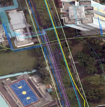
The International Archives of the Photogrammetry, Remote Sensing and Spatial Information Sciences, Volume XLII-4/W15, 2019
                                   14th 3D GeoInfo Conference, 24–27 September 2019, Singapore

   Event             Opportunity               Recommended           Lai, W. W.-L., Drobert, X. and Annan, P., 2018. A review of
                                               technique(s)          ground penetrating radar application in civil engineering: a 30-
   Utility           Line of sight; short      Conventional          year journey from locating and testing to imaging and diagnosis.
   installation      window of                 surveying; laser      NDT & E International 96, pp. 58–78.
                     opportunity               scanning
                     depending on                                    Makana, Lewis & Metje, Nicole & Jefferson, Ian & Rogers,
                     situation                                       Chris. (2016). What Do Utility Strikes Really Cost?.
   Trial trench      Line of sight; short      Laser scanning        10.13140/RG.2.2.14386.50883.
                     window of
                     opportunity                                     Novo, A., Manacorda, G., and Simi, A., 2013. Multichannel 3D
   Diversion         Line of sight             Conventional          GPR array systems: Recent results in engineering and
                                               surveying; laser      archaeology. 26th Symposium on the Application of Geophysics
                                               scanning              to Engineering and Environmental Problems 2013, pp. 433-
   Repair            Line of sight for a       Laser scanning        441.
                     small portion of the
                     utility; very short                             Osman, H., El-Diraby, T., E., (2005), “Subsurface Utility
                     window of                                       Engineering in Ontario: Challenges & Opportunities”, Centre for
                     opportunity                                     Information Systems in Infrastructure & Construction (I2C),
   Rehabilitation    Line of sight             Conventional          Department of Civil Engineering, University of Toronto, 2015.
   (open trench)                               surveying; laser
                                               scanning              Singapore Land Authority, 2017. Standard and Specifications for
   Rehabilitation    Accessibility from        Gyroscopic            Utility Survey in Singapore. Singapore Land Authority
   (trenchless)      the inside                mapping for           https://www.sla.gov.sg/Press-Room/Circulars/Land-Survey (15
                                               pipes that meet       July 2019).
                                               its criteria
   Replacement       Line of sight (in the     Conventional          Tham, I., 2019. Going Underground - Singapore's New Frontier,
                     case of open trench)      surveying; laser      The Straits Times, Singapore, 2 May 2019.
                     or accessibility from     scanning;
                     the inside (in the case   photogrammetry;       Urban Redevelopment Authority, 2019. Draft Master Plan
                     of abandonment of         gyroscopic            2019. Urban Redevelopment Authority
                     the old pipe)             mapping               https://www.ura.gov.sg/Corporate/Planning/Draft-Master-Plan-
  Table 2. Utility life cycle events and potential data capture      19 (15 July 2019).
                 opportunities and techniques.                       Van Son, R., Jaw, S.W., Yan, J., Khoo, V., Loo, R.S., Teo, S.,
                                                                     & Schrotter, G. (2018). A framework for reliable three-
                                                                     dimensional underground utility mapping for urban planning.
                  ACKNOWLEDGEMENTS                                   ISPRS Int. Arch. Photogramm. Remote Sens. Spatial Inf. Sci.,
                                                                     XLII-4/W10, 209-214.
This publication has been realized as part of the Digital
Underground: 3D Mapping of Utility Networks project at the           Zembillas, N., M., and Scott, P., C., (2010), The Evolution of
Future Cities Laboratory, established by ETH-Zurich and the          Subsurface Utility Engineering: From concept to Industry
Singapore National Research Foundation (NRF), and operating          Standard, North American Society for Trenchless Technology
under the auspices of the Singapore-ETH Centre. The project is       (NASTT), No Dig Show 2010, Chicago, Illinois, May 2,
funded by the UNDERGROUND-RELATED STUDIES AND                        2010.
PROJECTS FUND (USPF) of the Ministry of National
Development of Singapore and is sponsored by Singapore Land
Authority.

                        REFERENCES

Agentschap Telecom, 2018. Feiten en Cijfers over Schade door
Graafwerkzaamheden.               Agentschap        Telecom
https://www.agentschaptelecom.nl/documenten/publicaties/201
9/04/10/feiten-en-cijfers-over-schade-door-
graafwerkzaamheden-2018 (15 July 2019).

Energy Market Authority, 2019. Earthworks Contractors. Energy
Market                                              Authority
https://www.ema.gov.sg/Earthworks_Contractors.aspx (8 May
2019).

Impulse Radar, 2018. Raptor: High Speed Separable Shielded
GPR        Antenna        Solution.       Impulse        Radar
http://www.impulseradar.se/products/raptor/ (15 July 2019).

                                                 This contribution has been peer-reviewed.
                    https://doi.org/10.5194/isprs-archives-XLII-4-W15-97-2019 | © Authors 2019. CC BY 4.0 License.               104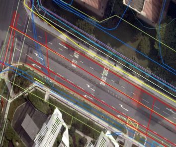
You can also read