Funding Provided by: Collaborative Organizations
←
→
Page content transcription
If your browser does not render page correctly, please read the page content below
Summary Report                                                                              April 2014
總結報告

Proposed
Tram & Pedestrian
Precinct in
Des Voeux Road Central
建議德輔道中
行人及電車專用區

Leading Organizations:                Collaborative Organizations:   Funding Provided by:

The Hong Kong Institute of Planners
Acknowledgements
Over the past year, we are grateful for the help of many individuals and organiztions who
have contributed to the fruition of this project and in bringing us closer to our dream of a
walkable Hong Kong city centre.                                                                 Contents
We would like to sincerely thank the WYNG Foundation and ADM Capital Foundation for
their generous funding to support the technical assessments of this proposal. The technical     Chinese Summary Report 總結報告(中文版) pi-ii
assessments significantly reinforced the merits of this proposal.

We would like to thank the volunteers of the Hong Kong Institute of Planners members who        1   Introduction                    p1-2
have contributed their time and insights to this project, including: Dr. Peter Cookson Smith,   2   The Problems                    p3
Mr. Ian Brownlee, and Ms. Yuen Yee Pong. We also would like to thank the HKIP Young             3   The Opportunities               p4
Planners Group Committee, who devoted their time, design and graphic skills to creating         4   Air Quality                     p4-5
outstanding urban design proposals. This includes: Mr. AJ Yum Chan, Mr. Benson Poon,            5   Transport and Traffic           p6-11
Ms. Caroline Chan, Mr. Edwin Tang, Ms. Kate Kwok, Mr. Mathew Fung, Mr. Chi Keong
                                                                                                6   Urban Design                    p12-23
Fung, and Ms. Stephanie Chan.
                                                                                                7   The Total Picture               p24
We would like to sincerely thank Civic Exchange for volunteering their time, support,           8   Implementation                  p25
office space and valuable advice to this project. Their team includes: Ms. Yan-yan Yip, Mr.     9   Conclusion                      p25
Simon Ng, Ms. Iris Chan, Mr. Keith Chan, Ms. Olivia Chen, Ms. Caroline Cottet, Mr. James
Cunningham, Mr. Martin Lai, Mr. Curtis Mak, Mr. Joe Pang, and Dr. Hilings Yip.
                                                                                                Separate Appendices Booklet
We would like to sincerely thank the volunteers of the School of Energy and Environment, City   Appendix 1: Air Quality
University of Hong Kong research team, who helped conduct the air quality assessments,          Appendix 2: Traffic Review
including: Dr. Zhi Ning, Mr. Ka Lok Chan, Dr. Nirmal Kumar Gali, Mr. Yang Hong, Miss            Appendix 3: Urban Design Proposal
Sabrina Yanan Jiang, Ms. Flora Chui Fong Lau, Mr. Wubulihairen Maimaitireyimu, Ms.
Agata Rakowska, Mr. Li Sun, Miss Viki Wai Ting Tong, Dr. Thomas Townsend, Dr. Dane
Westerdahl, Mr. Ka Chun Wong, and Mr. Fenhuan Yang.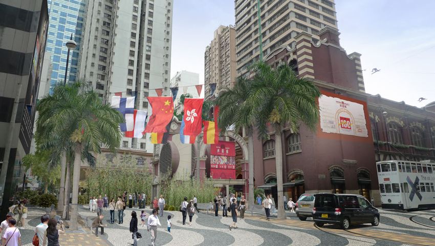
總結報告(中文版)
德輔道中行人及電車專用區建議

1. 背景                                             3. 空氣質素
1.1 香港規劃師學會聯同香港地下鐵路公司,由 MVA 提供交                   3.1 城市大學對該區進行了空氣污染研究,並與 MVA 的
通技術支援,於2000 年向政府建議,將德輔道中劃為行人及                     交通數字作比較,以找出問題的徵結。
電車專用區。該建議雖然可行,但未有實行。
                                                  3.2 數字顯示,區內整體上的空氣污染嚴重,而德輔道中
1.2 鑑於中環的空氣污染一直未有改善,而不久將來多項鐵路                     的空氣污染比起干諾道中及皇后大道中更為嚴重。雖然干
及公路陸續完工,為中環提供了一個改善環境的機會。學會遂                       諾道中的交通流量遠比德輔道中為大,但由於干諾道中的
於2013年初,與環境局聯絡,重提建議。此報告根據最新的政                     風速遠較德輔道中及皇后大道中為高,加上前者路面遠比
府及其他的基建項目,更新有關的資料及數字,並由城市大學                       後兩者寬闊,以及德輔道中及皇后大道中兩傍高樓林立,
提供空氣污染研究,與及MVA的交通研究、思匯政策研究所的                      密不通風,因而産生了峽谷效應,令污染物難以散去。
支援及 WYNG Foundation 及 ADM Capital Foundation 提供
的資助下,對畢打街至摩利臣街的一段德輔道中以及鄰近範圍                       3.3 此外,將週末與平常日的空氣污染與交通車輛組合的
進行研究。                                             數字作出比對後,發現污染的源頭主要來自柴油巴士及柴
                                                  油商業車輛。鑑於德輔道中的峽谷形態,除了將車流轉移
                                                  到干諾道中以減輕空氣污染的問題外,應該沒有其他途徑
2. 研究區的問題及機遇                                      可有效地改善德輔道中的空氣質素。
2.1 研究區雖然是香港的核心金融及商業中心,但一直都是空
氣污染最嚴重的地區之一,加上交通擠塞,缺乏綠化及行人設
施等,令到這商業中心的形象受損。
                                                  4. 交通研究
                                                  4.1 研究顯示,德輔道中沿路沒有直接的車輛出入口。西
2.2 另一方面,中環灣仔繞道、地鐵港島西線及南線分別於未                     行的交通以巴士及電車為主,私家車輛及運輸車輛較少;
來兩至三年完工。這些項目將可為巴士及其他車輛的路線重組                       東行的交通,私家車及運輸車輛的流量頗高。此外,嚴重
提供機遇,釋出空間並保留德輔道中作電車及行人之用,以改                       的問題亦包括交通擁塞及人車爭路等。
善該區的空氣質素與環境。
                                                                                  i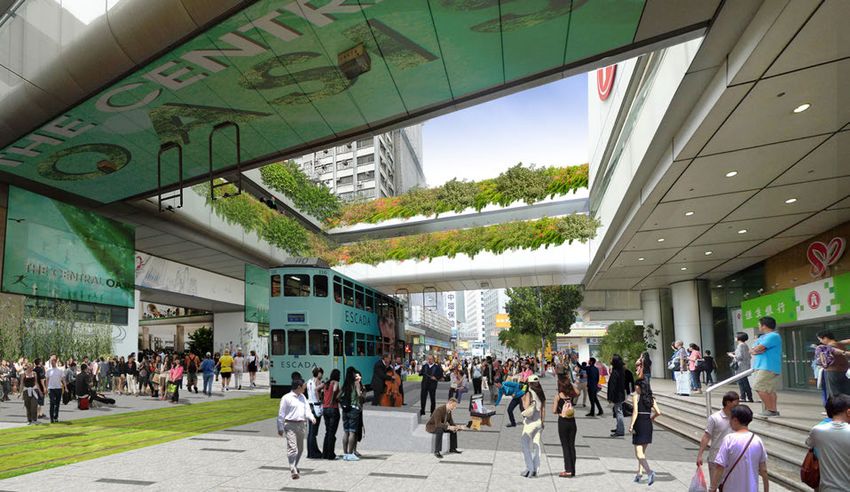
4.2 建議的行人及電車專用區,可分期進行。先導計劃範圍   5.3 建議故此包括運用富地區特色的綠化及景觀設計,將不同
     涵蓋摩利臣街至永和/林士街的一段德輔道中:西行線將摩利    的活動點連結起來,締造更有生氣的街道環境,為這個商業中
     臣街至禧利街的路段轉為電車專用區,而禧利街至永和街的     心注入生機及清新空氣,亦為市民提供優質的活動空間。這些
     一段則只供電車及巴士之用;東行線由摩利臣街至急庇利街     建議,可透過政府及小型工程項目進行。香港電車有限公司亦
     的路段轉為電車專用區,而急庇利街至林士街的一段則只供     表示支持有關綠化電車軌道的建議,並會負責執行。
     電車及巴士之用。現有的東行巴士路線大致上不受影響。先
     導計劃可以即時推行,期間亦可以同時進行改善行人設施的
     工程。
                                    6. 總結
                                     6.1 建議的願景是為改善香港的核心商業區-中環的環境。德
     4.3 待2017年中環-灣仔繞道工程完成後,一些駛經中環的交 輔道中的空氣污染問題,嚴重影響健康,由於峽谷效應,令污
     通可以轉用繞道,屆時德輔道中及干諾道中的交通流量將會 染物難以散去。建議希望透過交通措施與改道,解決空氣污染
     下降。以下的建議便可以推行:在部份的干諾道中設立東行 的源頭,保障市民健康。再利用區內不同的特色,以綠化及景
     巴士專線、巴士轉乘、將電車專用區伸延至畢打街、綠化電 觀設計方案,提供高質素的公共空間,改善區內的街道環境,
     車軌以及改善街道環境等。                    令中環與其金融及商業中心的形象相符,而不是長期高佔最嚴
                                     重空氣污染的榜首地區。
     5. 景觀設計                        6.2 為了確定建議能有效實行,建議採取有系統的分階段實施
     5.1 研究區內的兩旁被高樓所包圍,路面排放的污染物不能   策略,讓交通網絡能有效地應付改變的流量,以達到逐步改善
     散去,沿路景靚乏善足陳;加上擠迫的行人路、整段路缺乏     的目標。
     樹木,夏天行人需要在烈日下,忍受炎熱的氣溫,在污染的
     路旁活動。如現時的空氣質素、道路環境和行人配套不能得     6.3 計劃的落實,對營商環境和社會上下、不同人仕均有裨
     以改善,行人健康受影響,確是一個不宜久留的地方。       益。但能否實行,有賴政府的全力支持及公眾的參與,所以建
                                    議必需建立有系統的公眾諮詢程序。希望這計劃最終也能與海
     5.2 藉著這個改善空氣質素的機會,沿路的環境亦可作出相   外的成功例子一般,在得到大眾支持下成功實行。
     應的改善措施,提升形象。區內大致上可以分為三個特色小
     區:畢打街一帶為核心商業區、串連海傍購物區及南面蘇豪     (有關建議的詳細資料,可上 www.hkip.org.hk 閱讀)
     區的城中綠洲(前中環街市)為區內著名歷史建築物、西港
     城一帶則為較具傳統特色的行業。

ii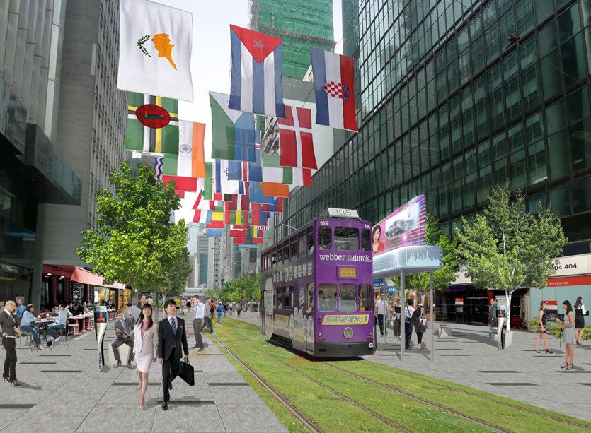
1 Introduction
1.1   In 2000 the Hong Kong Institute of Planners
      (HKIP), in collaboration with the MTRC and
      with technical assistance from MVA Hong
      Kong Limited (MVA), put forward a proposal for
      converting Des Voeux Road Central (DVRC)
      into a tram and pedestrian precinct. The
      proposal was accepted as technically feasible,
      but not implemented by Government. (Figure 1)

1.2   In early 2013, HKIP approached the Environment
      Bureau to see if the proposal could be revisited,
      as Central remained one of the areas of worst
      air pollution in Hong Kong. The completion
      of major highway and railway infrastructure
      between now and 2021 made a reassessment
      timely, as opportunities were going to arise
      which would enable significant improvements to
      be made to Central District.

1.3   This study therefore re-visited the 2000
      proposals and expanded them to look at air
      quality and both existing and planned transport                                                        Figure 1: A drawing of the 2003 proposal vision
      and traffic issues. The scope of our current        design enhancements, with the support from
      study looks at the section of DVRC between          Civic Exchange and generous funding of the
      Morrison St. and Pedder St. (Figure 2) Detailed     WYNG Foundation Limited and ADM Capital
      assessments and proposals have been                 Foundation. The detailed assessments are
      prepared by City University on air quality, MVA     included as Appendices 1, 2 and 3, respectively,
      on traffic and transport, and HKIP on urban-        to this Summary Report.
                                                                                                                                                               1
1.4   The study concludes that in the next few years there is a unique opportunity arising from the massive current public investment in transport infrastructure to
          significantly improve Central and to make it a high quality environment in terms of air quality, accessibility, and transportation. The proposed scheme would
          enable a high quality, pedestrian-friendly, and ‘greener’ Central, and provide a better place in which to work and do business.

                                                                                                                                         Figure 2: The Study Area
2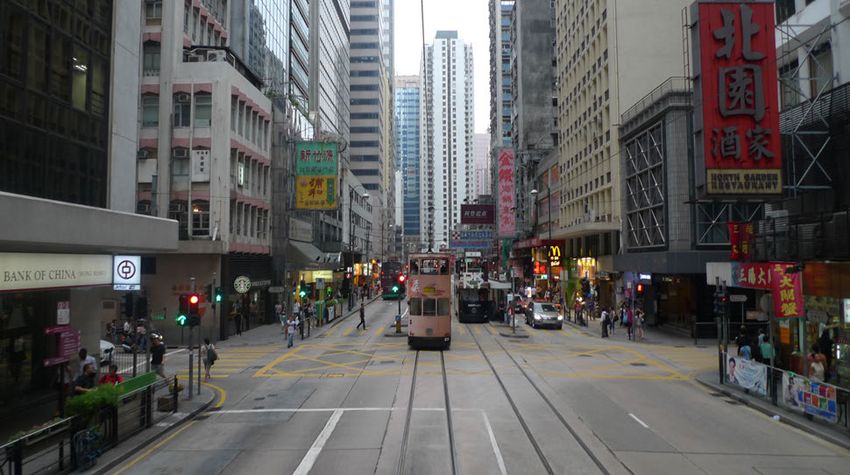
2 The Problems
2.1   The main problems identified are as follows:

           • The roadside air quality monitoring station for Central has consistently
           recorded high levels of pollution mainly arising from vehicles. Mobile
           air quality monitoring in the study area has shown that this problem is
           widespread; and a reduction in vehicle numbers is necessary.

           • Traffic congestion is creating delays to all forms of public transport other
           than the MTR, and this needs to be addressed to improve accessibility to
           the Central Business District. Traffic that flows through DVRC needs to be
           reduced and many of the buses using this road need to be diverted.

           • There is not one tree in DVRC and not enough greening, contributing to
           a hot and suffocating urban environment.
                                                                                             (Above) Photos showing examples of some of the problems.
           • Tall buildings with continuous facades lining both sides of the road forming
           a canyon-effect that traps pollutants and limits sunlight.                       • There is an absence of universal access for the elderly and disabled.

           • It is crowded and unpleasant to walk along the generally narrow and            • There is inadequate space for pedestrians and servicing activities, creating
           unsheltered pedestrian walkways.                                                 congestions in the narrow footpaths and forcing people onto the road
                                                                                            carriageways.
           • Street furniture and pavements do not have a consistent design theme.
           Seats are not available, which make it unwelcoming and disconnected.             • A lot of dangerous jay-walking occur at junctions.

           • Aside from a few planters on railings, no landscape greening is provided       • There is little street furniture and landscaping.
           along DVRC.
                                                                                            • There is no overall character or an identity that reflect this part of the city
                                                                                            as a major international financial business district. This does not reflect Hong
                                                                                            Kong’s self-proclaimed image as “Asia’s World City”.
                                                                                                                                                                                3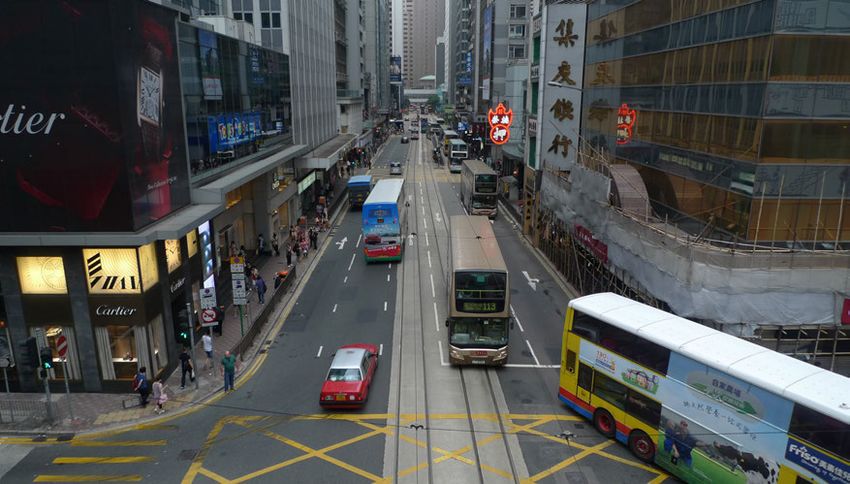
3 The Opportunities                                                                           4 Air Quality
    3.1   A number of factors present potential opportunities to address the prevailing
          problems:

               • The Central-Wanchai Bypass (CWB) and Lung Wo Road past Tamar, will
               relieve traffic from the existing road system allowing changes in function to
               the existing streets.

               • Part of the existing ramp from the elevated road to Connaught Road
               Central (CRC) next to the Harbour Building, will be demolished as part of
               the CWB project, providing space which could be used as a bus priority
               route and for better public transport interchange facilities.

               • For the MTR, the West Island Line (WIL) will be operating by 2014 and
               the South Island Line (SIL) by 2015 providing improved railway access. As
               a result, bus routes will be reorganized to integrate with the new railways.

               • Traffic from DVRC can be diverted to CRC and bus services enhanced.

               • Main traffic in DVRC could be just trams and some bus routes.
                                                                                                        Figure 3: Scope of air quality measurements
               • The air quality would be improved by diverting the polluting traffic including
               buses.
                                                                                                  4.1   A road-side and street-level air quality assessment was carried out by the CityU
                                                                                                        team, then real-time traffic data (provided by MVA) was linked with the air quality
               • Street space in DVRC can be pedestrianized and landscaped with
                                                                                                        data and it clearly revealed the sources of air quality problems in the area
               improved urban design elements.
                                                                                                        (Appendix 1). Total of four sampling days were investigated with three weekdays
                                                                                                        of 31 July, 3 August and 27 October and a proceeding Sunday of 28 October,
                                                                                                        2013. The choice of three weekdays with a long time span intends to investigate
                                                                                                        the repeatability of observations, and the weekend day was included to show the
                                                                                                        contrast of traffic composition.
4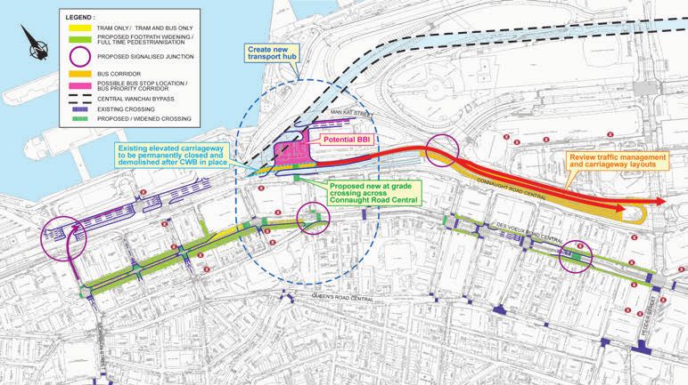
4.2   For each sampling day, three identical time periods were selected for investigation
      covering morning rush hours, noon, and evening rush hours. Nine traffic counting
      points for traffic volume and composition, and two sampling routes for on-road
      and roadside measurements of air pollutants were performed concurrently and
      repeatedly. (Figure 3)

                                                                                            Figure 5: Comparison of traffic counts and pollutant measurements,
                                                                                            where DVRC has highest pollutant records while CRC has highest
                                                                                            traffic volume

                                                                                                • It was determined through comparing the traffic composition of weekday
Figure 4: Surface wind speed with highest for CRC and lowest for QRC                            and weekend measurements that significant air pollution came from diesel
due to difference in streets openness                                                           commercial vehicles and the diesel franchised bus fleet.

• Wind speed data along the streets showed highest velocity for CRC, then decreases             • Diverting buses from DVRC to CRC will result in significant improvement of
significantly while moving inland to DVRC and Queens Road Central. This was in part             air quality in DVRC, where there would be no significant impact on air quality
due to the urban geography and street layout of the three roads, where a canyon effect          along CRC.
can be seen in DVRC and QRC (Figure 4).
                                                                                                • The existing urban design of DVRC street forms canyon effect by dense and
• Air quality measurements confirmed that poor air quality is widespread throughout the         high rise buildings which means that significant improvement of air quality can
area. Although CRC has 10 times more traffic than DVRC and QRC, the worst air quality           only be made by removal of diesel fleets from the street.
persists in DVRC due to strong street canyon effects in DVRC. (Figure 5)
                                                                                                                                                                                  5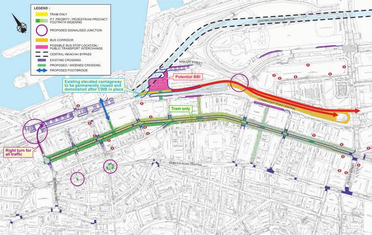
5 Transport and Traffic
    5.1   Today a number of major infrastructure schemes are under implementation and
          now provide a golden opportunity to comprehensively review the allocation of
          street space to revitalise and enhance the built, living and walking environment in
          the CBD. (Figure 6a and 6b)

    5.2   The vision behind the scheme is to create a dramatically improved street
          environment in DVRC, where pedestrians and street activities have priority,
          and the physical (air quality, noise levels and safety) environment will meet the
          highest standards and improve the overall quality of environment in Central
          over the coming years. At the same time, accessibility to public transport will
          be promoted by improved pedestrian networks, new public transport priorities          Figure 6a: Future railway network
          and the necessary servicing and traffic access provided as to maximise area
          for pedestrian circulation and landscaped, as well as minimise traffic and air
          pollution for roadside area with air quality issue.

    5.3   To achieve this goal, the following ideas were investigated:

             • Divert through traffic from DVRC to Connaught Road Central and CWB, and
             give priority to pedestrians and essential access traffic only;
             • Convert DVRC to a traffic free pedestrian and tramway precinct in the long
             term;
             • Promote integration of the rail and road-based public transport through the
             development of strategic interchanges, service coordination and enhancement
             of the pedestrian network; and
             • Ensure bus service performance by exploring possibility to provide bus
             priority on Connaught Road Central.
                                                                                                Figure 6b: Future highway network
6
5.4 With the review of the existing conditions along DVRC, the following constraints • Traffic volume for private and goods vehicles travelling in the eastbound direction
and opportunities were identified. (Figure 7) is generally higher than the westbound direction as the eastbound direction of
• No vehicular access is provided at DVRC; DVRC presently provides an important eastbound route for development traffic in
• Non-stopping Clearway Restrictions (NSR) are implemented along DVRC the locality; and
and servicing activities are mainly restricted to nightime; • Geographically, DVRC forms the main spine of the CBD and is the key development
• Traffic volume for private and goods vehicles travelling along in westbound corridor with office and commercial developments along its whole length. Footpaths
carriageway of DVRC is light, as the section of westbound carriageway of on both sides are in general approximately 3 meters wide. Serious congestion
DVRC between Pedder Street and Jubilee Street is already a tram and bus frequently occur at junctions when large crowds of pedestrian waiting to cross at a
only corridor; constrained space. It is very common to observe jay-walking and pedestrians over-
spilling onto carriageway during peak periods on weekdays.
Figure 7: Existing Traffic constraints and opportunities
7Initial Scheme 5.8 The Initial Stage at the western and eastern section of DVRC can go ahead in the
short term independently and its impact will become even less apparent as the
WIL and then other infrastructure schemes are completed.
5.5 Based on the above, the western section of DVRC between Wing Wo Street and
Morrison Street was identified to have the lowest traffic volume for both buses,
private and goods vehicles among the other sections. Hence, it is envisaged that
the conversion of this western section to pedestrian/ tram precinct would have the
least traffic impact to the surroundings as compared with other sections, and can
be implemented in the short term.
5.6 In the initial stage (Figure 8), it is proposed to convert the section of westbound
carriageway between Morrison Street and Hillier Street to tram only and the
section between Hillier Street and Wing Wo Street to bus and tram only as to
minimise re-routing of the existing bus services. In the eastbound direction, it
is proposed to convert the section between Morrison Street and Cleverly Street
to tram only and the section between Cleverly Street and Rumsey Street to bus
and tram only. With this proposed arrangement, the existing bus routes travelling
along DVRC in the eastbound direction would not be affected. For the rest of
eastern section, it could be improved via various measures such as simplifying
the method of control, providing built-out at some crossing points etc. With this
proposed arrangement, the existing bus routes travelling along DVRC in the
eastbound direction would not be affected.
5.7 With the proposed conversion, this could reduce traffic volume and hence
improving air quality and minimise conflict between vehicular traffic and
pedestrians. Also, footpaths along DVRC could be generally widened from about
3 metres to about 7- 8.5 meters, which offers great potential for increasing space
for pedestrian circulation and landscaping amenities.
Figure 8: Initial DVRC scheme
8Figure 9: Potential bus priority and traffic management improvement related to opening of CWB
9Further Evolution 5.10 The Ultimate Plan is more far reaching and requires more extensive traffic
rerouting and management changes and a comprehensive review of the bus
network in Central District. This should commence when CWB is completed
5.9 Further development beyond the initial scheme could follow with the opening of and condition can be reached when SCL is completed by 2020 when there is
the CWB in 2017. This could include:- scope to rationalise cross harbour buses.
• Further strengthening of bus corridor on CRC and pedestrian priority areas on
DVRC. These include a bus priority corridor along the eastbound carriageway
of Connaught Road Central by making use of a section of the existing
eastbound elevated road of Connaught Road between Man Kwong Street and
Man Chiu Street which will be removed and converted to planters under the
gazette plan after the opening of CWB, a Bus-to-Bus Interchange (BBI), and a
diversion of bus routes from DVRC to CRC together with rationalisation taking
into account, the availability of the BBI. (Figure 9)
• The existing bus terminus located adjacent to the Harbour Building could be
converted to a BBI to reduce long haul bus services and rationalise existing
bus services. (Figure 10) For example, long haul cross harbour bus services
from WHC could interchange with island bus routes or other mode of public
transports such as MTR and tram at the interchange to reduce bus volumes
and consequently improve traffic condition and bus services.
• After gradual diversion and rationalisation of bus routes from DVRC, the
traffic volume along DVRC would be greatly reduced. By 2020 when SCL is
opened and East Rail terminating on Hong Kong Island, there exists further
potential to rationalise cross harbour bus routes thereby further reducing bus
volume through the CBD. Together with diversion of general traffic from DVRC
to the wider street system, the ultimate plan of converting the whole section of
DVRC to a tram and pedestrian precinct would be tenable. (Figure 11)
Figure 10: Conceptual Plan for Public Transport Interchange at Connaugh
10It is critical to have a balanced and comprehensive plan for the CBD in order to 5.11 It is critical that the new CWB is not simply taken up by traffic growth in time. It
capture the opportunities brought about by the new infrastructures. In summary: should be treated as an opportunity to reallocate road space for revitalisng the
• DVRC can become a pedestrian and tram precinct with minimum level of streets and environment of Central as part of a pedestrian and public transport
other road traffic; while strategy.
• CRC can be the primary bus corridor and traffic distributor; and
• CWB can function as a bypass for strategic traffic, and entry/exit to Central.
ht Road Central Figure 11: Further evolution of DVRC scheme
116 Urban Design 6.1 The Young Planners Group Committee of the Hong Kong Institute of Planners, with the guidance of
senior members of the Institute, undertook an urban design study to propose and illustrate potential
improvements to the urban environment in DVRC for the enjoyment of pedestrians and visitors. The
team has also looked at applicable overseas case studies on which to base successful urban design
features. (Appendix 3)
An overriding objective of the urban design proposal is the
provision of a more connective structure within the wider
CBD and along DVRC. This includes (Figure 12):
• The mix of luxury brand shopping nodes at Pedder
Street, IFC and the Landmark and hawker shopping
streets (e.g. Lei Yuen Street East and West).
• The future “Central Oasis” which will continue to
form an elevated connection between the mid-levels
escalator to the Soho area and the waterfront.
• At the Sheung Wan end, the commercial shopping
node with local businesses of dried seafood shops,
restaurants, fruit stalls, stationary shops, household
item shops, and small shopping stores like Infinitus
Plaza, Cosco Tower and Wing On Centre, etc.
• The matrix of commercial businesses, like dried goods
shops, restaurants and department stores that are
related to the historic Western Market in the Sheung
Wan area.
Figure 12: Relation of DVRC to Main Activity Nodes.
12Urban Design Proposal
The Western Market
6.2 • The overall urban design concept is to provide
for a comfortable shopping and leisure destination
where residents and office workers can enjoy a
relaxing but stimulating urban experience at street
level, in the heart of the CBD, in contrast to other The
traffic congested streets. We are confident that
this would also be a positive thing for Hong Kong’s Central
international image. Market
• The study would build on three existing activity
nodes along DVRC enabling a new place making
approach. At the eastern end would be the Financial
Market, a place that would reflect the financial
and business sector. The Central Market at the
mid-portion would be anchored by the Central
Oasis, a commercial hub with performances and
exhibitions, and a gateway to the attractions on
The
Central Mid-levels escalators. At the western end Financial
would be the Western Market, a heritage building
containing small shops and businesses. (Figure
Market
13)
• Sitting out and resting spaces have been
designed for both passive and active uses to Figure 13: Overall Layout Plan and Activity Nodes
reflect the urban character at these nodes.
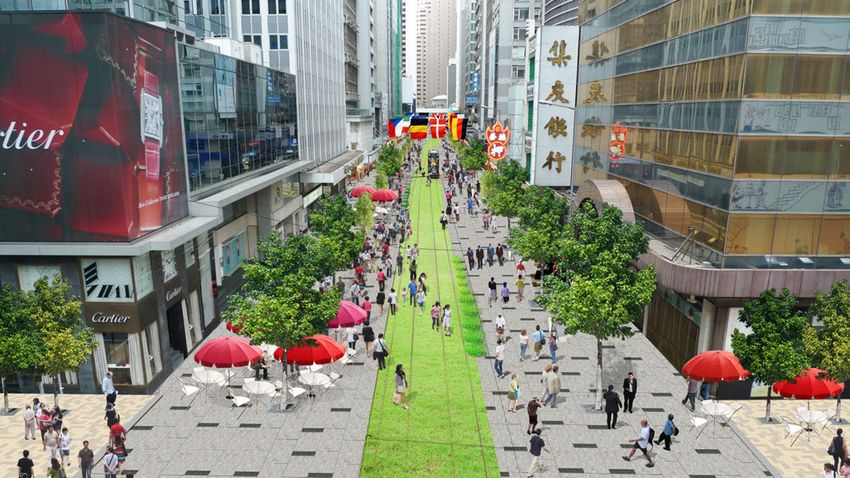
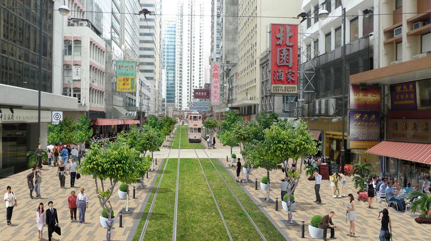
• A grassed “carpet” running along the tramway on DVRC, would accentuate the pedestrian setting, create a
unique sense of place, and contribute to better air quality and environmental friendliness. This grassed tramway
would create a visual and physical continuity along the entire length of DVRC. (Figure 13)
• Extensive planting of trees and other landscaping features to reduce heat and soften the built environment.
13The Financial Market
6.3 • Within passive open spaces, special design and color
schemes are proposed for the street furniture, pavement
and other features, echoing the surrounding modern
buildings.
• Visual design elements with simple geometry, such as
linear seating to provide relief from constant activities of
the street.
• Outdoor high-tech LED display panels and signage to
reflect the modern CBD character.
• An extension of landscape, paving and signage to the
adjoining hawker lanes of Lei Yuen Street East and Chiu
Lung Street.
Before, Photomontage 1: Looking towards Sheung Wan from Pedder St. junction.
14After, Photomontage 1: Looking towards Sheung Wan from Pedder St. junction
15Before, Photomontage 2: Looking towards Central from Jubilee St. 16
After, Photomontage 2: Looking towards Central from Jubilee St.

                                                                  17
The Central Market
6.4 •This mid-section of DVRC sits within the financial district and focuses on an open space • It is intended that the design and landscape character should gradually
between the Hang Seng Bank Headquarters and the Central Oasis (formerly the Central change from east to west, with gradation in forms of urban texture, planting,
Market) building. and color themes.
• The urban design proposal for this area is for an exhibition, performance and seating
area consistent with the revitalization plan for the Central Oasis. This would spatially
extend the indoor spaces to outdoor features, creating an interesting and active interface.
The public would be able to view the area from the two existing elevated walkways.
Before, Photomontage 3: Looking towards Central from Jubilee St.
18After, Photomontage 3: Space on DVRC between Central Oasis and Hang Seng Bank Headquarters.
19The Western Market
6.5 • The Sheung Wan area represents in part a local street culture of small • A new public piazza and potential performance area is proposed, where temporary
businesses. The major landmark in the area is the Western Market building. closures of the New Market Street would allow space for temporary movable
plantings and street furniture, and passive areas for pedestrians to sit and enjoy the
• At this end, it is proposed to have paving patterns and street furniture shapes environment.
with a warm color, having a wavy and curvy design to create a casual walking
ambience. This would act to make the Western Market building more accessible • Space for alfresco dining for the restaurants would be provided alongside DVRC,
to the public. activated by movable planters, and street furniture to provide a convenient and
comfortable environment for users.
20 Before, Photomontage 4: Existing context at Western Market.After, Photomontage 4: Proposal at Western Market. 21
Before, Photomontage 5: Existing context looking towards Western Market at Hillier Street.

22
After, Photomontage 5: Proposal looking towards Western Market at Hillier Street.

                                                                                    23
7 The Total Picture
7.1 The vision behind the DVRC proposal is to create a dramatically improved 7.5 There are many real benefits that can arise from this scheme. However, it is
street corridor environment for the local community and visitors in the heart critical that the additional capacity that will be provided with the opening of the
of the CBD, and to create a new and revitalized identity for Central. At the Central-Wanchai Bypass not simply be taken up by traffic growth, and that the
same time, accessibility to public transport will be promoted by improved opportunities for revitalizing the streets of Central are not missed. The present
pedestrian networks and traffic facilities. study provides a strategy to systematically improve the urban environment, public
transport and pedestrian comfort and circulation.
7.2 The environmental and health benefits arising from removal of vehicles from
the streets is an important gain that has been documented in this study. It
is imperative that opportunities presented for improving air quality through
the opening of new major transport infrastructure should be exploited in full.
7.3 The proposal relates to landscape and urban design improvements
which will revitalize the whole of the entire CBD and improve the external
environment of Central to match the high internal design quality of the new
office buildings. The quality of the public realm needs to be commensurate
with Hong Kong’s importance as a world economic centre, and to help
achieve the goal of being Asia’s World city.
7.4 Similar proposals have been carried out successfully in many major cities
throughout the world, where tram and bus priority areas have helped
to revitalize city centers. While there may be initial resistance to such
changes, they are eventually shown to be good for business and good for
social interaction.
248 Implementation 9 Conclusion
8.1 Implementation will be dependent on Government accepting the proposal. 9.1 Air pollution along the DVRC needs to be addressed urgently. With this
The time frame itself relates to the impending completion of the major road proposal the major pollution sources in DVRC, i.e. the buses and diesel
and railway infrastructure. commercial vehicles, will be removed, leaving the space to trams and
pedestrians. This will help achieve the air quality objectives for the CBD,
creating a higher overall quality of environment.
8.2 All of the land involved is government land and most of it is currently used as
roads, footpaths or transport facilities. The proposed changes are relatively
small in terms of cost and scale and some could be carried out under normal 9.2 The urban design schemes would provide landscape greening, link
Highways Department maintenance contracts. Others may require small together activity nodes, and bring vibrancy to DVRC with the potential for
contracts to carry out significant footpath widening and landscaping. Hong street level events, activities, and new amenities for pedestrians. These
Kong Tramways Limited have indicated that they support the proposed improvements would create an overall pedestrian-friendly environment
grass tram track and could help implement it. in the city centre.
8.3 The proposed scheme would be implemented in two stages. The Initial 9.3 Implementing the proposal will ultimately require full Government support.
Stage could, in theory, go ahead immediately and would benefit further as Positive public engagement will be an important factor in determining
the West Island Line and then other transport and infrastructure schemes public support and achieving a successful outcome.
are completed. The detailed assessment of the Initial Stage confirms that it
is feasible in traffic and transport terms and will bring substantial benefits to (For more information, please visit our website: www.hkip.org.hk)
pedestrians and travelers.
8.4 Public support for the proposal will be important and it is one of the
recommendations of the study that a systematic public engagement process
be undertaken.
25You can also read