GEOMATICS IN THE MANAGEMENT OF BUILT HERITAGE THROUGH BIM SYSTEMS. THE TRAINING OF NEW EXPERIENCED PROFESSIONAL FIGURES.
←
→
Page content transcription
If your browser does not render page correctly, please read the page content below
The International Archives of the Photogrammetry, Remote Sensing and Spatial Information Sciences, Volume XLIII-B5-2020, 2020
                                               XXIV ISPRS Congress (2020 edition)

     GEOMATICS IN THE MANAGEMENT OF BUILT HERITAGE THROUGH BIM
    SYSTEMS. THE TRAINING OF NEW EXPERIENCED PROFESSIONAL FIGURES.

                                                           A.Adami 1 *, L. Fregonese 1
                          1 Dept. of Architecture, Built Environment and Construction engineering (dABC),
                                    Heritage Survey Technology group (HeSuTech), MantovaLab,
                 Politecnico di Milano, Polo territoriale di Mantova, via Angelo Scarsellini, 15, 46100 Mantova, Italy
                                              (andrea.adami, luigi.fregonese)@polimi.it

                                                       Commission V, WG V/1

KEYWORDS: Training curriculum, Geomatics, HBIM

ABSTRACT:

Geomatics is trying to redefine its role in the Italian higher-level educational system according to the new technological
developments. The recent thematic thread of Building Information Modelling (BIM) systems contributes to the new role of
Geomatics inside universities and, more generally, in the training process. BIM systems propose new ways of managing the
construction process throughout building life cycle, from design to construction and management. They allow managing large flows
of information, organized and shared among the different operators in the construction chain, through databases linked to three-
dimensional objects. The BIM approach is based on two principles: interoperability and digitization.
BIM was born as an application dedicated to new buildings, to promote the optimization of the entire life cycle of the building, from
design to management. Many countries have been active in this sector for years, while others are now joining the digitization
approach. In this complex scenario, the proposal to adopt the BIM process not only for the management of new constructions but
also for the intervention on the existing one, is relevant in a country, like Italy, with a very rich history and a high presence of built
historical heritage. Maurice Murphy coined the term HBIM (Historic Building Information Modelling), referring to BIM systems
applied to historical buildings that need intervention and subsequent management.
Geomatics plays a crucial role in HBIM as it is the primary tool for the digitization of built heritage and to obtain a model of the
existing, an "as-built" model. In order to achieve this result, laser scanner and photogrammetry are the main tools, and they are
involved in the so-called Scan2Bim process. The other important role is connected with the modeling stage to arrive at a three-
dimensional representation suitable for common BIM authoring software while maintaining the rigor and accuracy that characterize
the geomatic approach.
The fundamental role of Geomatics in this context requires the training of personnel specialized in surveying and managing the
acquired data through HBIM systems. There are new training courses and masters in the field of BIM systems, hosted by Politecnico
di Milano at the Mantua Campus, aimed at training new figures with a specific curriculum, including Geomatics.
The elements that characterize the training course are the knowledge of the principles and methods of data and the evaluation of
achievable accuracy and admissible errors. It is also important to address issues that are still not completely solved in HBIM
community, such as the type of modeling the best levels of detail of geometric and information content and the most practical aspects
of commercial BIM authoring software.
The article describes the experience carried out by Politecnico di Milano and tries to define, afterward, the training curriculum for
HBIM experts, in which Geomatics plays an essential role, not only in the data acquisition phase but also in geometric and
informative modeling.

                     1. INTRODUCTION                                   European BIM market was 1.8 billion EUR in 2016, and it is
                                                                       expected to grow up to 2.1 billion EUR by 2023 (European
1.1 BIM adoption and training.                                         Construction Sector Observatory, 2019).
                                                                       However, BIM also represents a significant step forward for the
Building Information Modelling (BIM) is one of the most                public sector; it allows to reach relevant social outcomes,
interesting and topical issues both in the professional and            especially related to the topics of urbanization, population
research fields.                                                       growth and energy efficiency upgrading. We should also
The adoption of new systems for the management of the                  consider the advantages, for public sector, in the management of
construction supply chain, in all its stages, represents a resource    public buildings with more efficient public spending and a
in the professional field for the many advantages it brings, like      more sustainable use of shared spaces.
improved efficiency, reduced waste, and better project                 We should also consider all the improvements connected with
management. Digitalization is very relevant for private sector         better building quality and efficiency, management of built
companies as they have financial interests in the passage to the       environment, sustainability, and budgeting.
latest digital technologies. The overall business impact of BIM        The growing interest in BIM, justified by all these advantages,
is apparent in industry figures. The estimated value for the

* Corresponding author

                                                This contribution has been peer-reviewed.
                   https://doi.org/10.5194/isprs-archives-XLIII-B5-2020-9-2020 | © Authors 2020. CC BY 4.0 License.                     9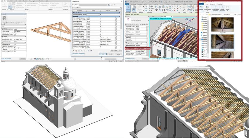
The International Archives of the Photogrammetry, Remote Sensing and Spatial Information Sciences, Volume XLIII-B5-2020, 2020
                                               XXIV ISPRS Congress (2020 edition)

is also proven by its increasing popularity and adoption,              public works with a tender value of EUR 100 million or more
supported by the regulations of individual countries (public) and      must adopt a BIM approach. With a proportional logic, the
by the industry (private).                                             same decree obliges the use of BIM for all public works from
We can see a confirmation of this great interest in the                2025 onwards, regardless of tender value.
establishment of EU BIM Task Group in 2016                             From a normative point of view, instead, the essential reference
(http://www.eubim.eu/), which aims to develop a world-class            is the ISO 19650, adopted in Italy as UNI EN ISO 10650-1 and
digital construction sector. The group published a handbook            UNIEN ISO 19650-2:2019. In the Italian case, there was a
(EU BIM Task group, 2018), intended to encourage a wider               detailed regulatory status, so it was preferred to establish that
introduction of BIM in response to the growing challenges              the whole of UNI 11337, in all its parts, is the attachment of
faced by governments across Europe and public clients to               ISO 19650.
stimulate economic growth and competitiveness while
delivering value for public money. It also demonstrates the            To understand, instead, the current level of adoption of BIM in
importance of coordinated public sector action across both             Italy, the reference document is the Rapporto Oice sulle gare
European and national levels to drive towards this vision.             BIM 2019 (OICE report on BIM tender 2019), published in
In the same direction of public involvement for the support of         February 2020 (OICE, 2020). OICE, the national association
BIM, we can count the numerous standardization initiatives             representing the Italian engineering, architecture and technical-
proposed by many European or institutions.             From the        economic consulting organizations, states that in 2019 BIM
"International Organization for Standardization" (committee            calls for tenders represent 8% of the market of all engineering
ISO/TC 59/SC), and the "European Committee for                         and architecture services, with an increase of 58.3% compared
Standardization (committee CEN/TC 442, to the regional ones            to the previous year (in 2018, the increase was 263.9%
(in Italy, they are represented by UNI).                               compared to 2017).
We should also mention the efforts of BuildingSmart                    In order to go deeper into the topic of HBIM, it is useful to note,
(https://www.buildingsmart.org) in the definition of IFC               again in the same OICE report, that 63.4 % of the BIM calls for
(Industry Foundation Classes) to foster the exchange and               tender concern renovations.
sharing of data among different BIM software.

In spite of the many efforts to spread this digitalization                     2. BIM AND HBIM: SIMILARITIES AND
approach, we observe that the level of BIM adoption in different                         DIFFERENCES
countries is very different. In a schematization, (Panteli et al.
2020) state that the countries that are more advanced in the           The data and trends described in the previous paragraphs
national legislation adoption process are those of Northern            confirm the growing diffusion of BIM in Italy, but highlight that
Europe and in particular Finland, Sweden, Netherlands,                 the field of application is very often the built heritage, even if
Norway, and the United Kingdom. An intermediate situation,             with different historical and artistic characteristics. Although the
instead, regards a group of countries that are moving towards          data refer to the Italian situation, it is clear that all countries
the adoption of BIM systems, by the definition of a roadmap            with a significant and widespread built heritage are in the same
and standards in digitization procedures. Among them, we count         working condition.
France, Italy, Germany, Spain, Austria, and Denmark. Finally,          In such a context, the designation of a new paradigm of BIM,
the last group, with the Czech Republic, Lithuania, Cyprus, and        firstly described by Murphy in 2009 (Murphy et al., 2009),
Greece, is still at low levels, although growing.                      called HBIM (Historic Build Information Modelling), becomes
A large number of educational activities support the increased         very relevant. The high number of scientific works in the HBIM
adoption of BIM. Many universities and research centers offer          field produced in Italy is an indication of the great interest
training courses in BIM. These are generally postgraduate              concerning both the economic and research area.
masters, more or less specialized in a specific sector of the          And if we assume this new paradigm, it is necessary to define
complex BIM environment. There are also professionalizing              the peculiarities of both approaches: BIM and HBIM.
courses, even more specific, which are often held by private           Much literature on HBIM (Lopez et al., 2018) (Bruno, Roncella,
institutions, which are part of the construction sector. On the        2019) focuses on the differences and similarities between these
contrary, it seems that there are no degrees specifically              two approaches. This analysis is fundamental to develop a
dedicated to BIM, and the single courses are mainly in                 specific training curriculum with the aim of creating new
engineering faculties and, only in a small part, in architecture.      professional figures of HBIM operators.
                                                                       The main difference between BIM and HBIM concerns the
1.2 Italian adoption of BIM.                                           object of the intervention. In the first case -BIM- the aim is the
                                                                       design and construction of new buildings. Instead, HBIM
The proposal of a specific curriculum related to BIM systems           focuses on an existing building which requires various kind of
applied to the built environment deals with the local situation.       interventions:     conservation,      restoration,    re-use,   and
For this reason, it is appropriate to better study the Italian case,   rehabilitation.
in particular, analyzing the legislation, the adoption of the BIM,     These first, and obvious, difference determines very relevant
and even the construction sector.                                      effects, especially with respect to the knowledge of the building.
From a legislative point of view, the fundamental administrative       In new constructions, the designer defines, independently, or
act is the Ministerial Decree 560 of December 1st, 2017 - also         through coordinated teamwork, all the characteristics of the
called BIM Decree. In the decree, the Ministry of Infrastructure       building (shape, geometry, size, construction technologies, and
and Transport defines the methods and timing for the                   materials used). We can say that the knowledge of the building,
progressive adoption of specific digital methods and tools by          or rather "how it will be", is very precise and accurate. In the
the contracting stations, the granting authorities and economic        case, instead of the intervention on the built heritage,
operators. For example, the obligatory use of BIM modeling             knowledge is a great challenge since it will depend on a series
tools for construction and infrastructure in the design,               of analyses, more or less invasive, on the building itself.
construction, and management phases of the works and related           Through architectural surveys, structural investigations, tests on
checks. This decree stipulates that from 2019, all complex             materials, and in-depth documentary research, it will be possible

                                                This contribution has been peer-reviewed.
                   https://doi.org/10.5194/isprs-archives-XLIII-B5-2020-9-2020 | © Authors 2020. CC BY 4.0 License.                     10
The International Archives of the Photogrammetry, Remote Sensing and Spatial Information Sciences, Volume XLIII-B5-2020, 2020
XXIV ISPRS Congress (2020 edition)
to collect much of the information necessary to describe the elements that are different in reality and that the restoration
building. disciplines, even with varying degrees of intervention, struggle
An architecture, however, is not only the result of a building to make homogeneous.
process. It is the outcome of a temporal process that can lead to Many of these issues can be, if not really solved, at least
transformations over time, and we cannot find traces of them in addressed through the methods of Geomatics and having clear
documents or in the building itself (especially if we do not the role of BIM and the needs of each area.
know where to look for). The process of analysis that leads to
knowledge of the building is rarely linear in nature but involves 3. ROLE OF GEOMATICS IN A HBIM TRAINING
a continuous going back to the building to discover something CURRICULA
new. While it is true that BIM systems provide the possibility of
enriching the model with information at every stage of the 3.1 Role of Geomatics in academic training
process, it is equally true that we need a reasonable starting
basis for building the model that will index all the data. Geomatics is the modern name that brings together the
As described below, geomatics instruments and methods play a traditional disciplines related to measurement and control such
fundamental role in the knowledge of the building, but they also as topography, photogrammetry, GPS, remote sensing, GIS, etc.
reveal some weaknesses that lead to essential gaps. Based on In the training path of the architect, Geomatics plays a very
optical systems, the two most commonly used methods - laser different role from university to university. Very often, The
scanner and photogrammetry- allow to know the skin of the courses of Architectural Survey deal with photogrammetric and
building, but not the inside of the walls and the other hidden laser scanner techniques, but BIM and HBIM are not addressed.
parts. Other destructive analyses, typical of the restoration site, Usually, these courses aim to produce, as a final result,
such as coring on wall tests, allow a punctual knowledge, which traditional two-dimensional representations, and also three-
cannot be extended, with certainty, to the whole building. dimensional models, but they are not realized with the logic of
Finally, analyses of a structural nature give general indications an informative system as BIM. BIM systems are, instead, the
on the structure but say very little about the individual objects, prerogative of other disciplines, such as construction
which in reality constitute the essential element of BIM. technology, and, only in a few cases, the fields of Geomatics are
Furthermore, the diversity of subjects of intervention between integrated with those of construction technology.
BIM and HBIM - new construction or existing building - poses Engineering schools have a more in-depth approach to geomatic
other problems related to the interpretation of architecture and disciplines, both for surveying and monitoring. Also in this
its modeling. On the one hand, in fact, it is necessary to know case, despite a greater depth, the link between Geomatics and
the historical construction techniques in order to characterize BIM systems is not an institutional subject of the course, but,
the technological elements. A barrel vault, for example, cannot where practiced, is still a personal choice of the teacher.
be realized only taking into account the geometric shape, but we We can find greater integration, instead, in post-university
should consider its thickness, static functioning, material, and courses such as first and second level masters (according to the
construction technique. The same concept is described in national classification) and other more specific training
(Adami et al., 2019) for the HBIM of the Cathedral of Mantua activities.
and especially for the modeling of the main façade, taking into
account the historic constructive technology and documents. 3.2 Master HBIM and geomatics curriculum
On the other hand, it is essential to divide the complex object,
the architecture, into smaller and simpler elements, the objects Politecnico di Milano, already active with other masters
of BIM approach, according to a logic that is typical of dedicated to BIM, proposes a new course dedicated to HBIM
information modeling. In this way, the issue of semantic systems that starts, through geomatic methods., from a strong
classification is tackled, with all the difficulties of finding a integration between the design and management of architecture
subdivision that is functional to the intervention but respectful and the documentation of architecture itself.
of the characteristics of the building and the HBIM approach The aim of the master is to educate specialized operators to
(Adami et al., 2018). work on the existing heritage, through BIM systems. The course
Then we find the problem of modeling, that is, the passage from includes three main areas (conservation, plant design, and
acquired data (usually a point cloud with direct measurement structural design) in addition to a module, preparatory to all the
integrations or, when it is not available, a series of two- other three, related to the theme of the survey and digitization of
dimensional drawings) to a three-dimensional parametric buildings. As an outline of all this, some modules are linked to
model. There are many researches suggesting to use tailor-made interoperability and data exchange through IFC, database
systems (Banfi, 2019) and open-source solutions (Fregonese et structuring, management of safety aspects of the building site,
al., 2017). But in the labor market, this is very difficult, and so and current regulations.
the modeling stage takes place through commercial software The logic of the master is to provide not only the individual
that has been implemented for new constructions. This choice is skills but to relate them to each other, as already happens,
necessary, of course, to follow the economic, temporal, and without the BIM approach, in the architecture project.
resource optimization criteria that a real intervention requires. The training in the geomatic field provides about 70 hours
But it also leads to problems in the representation of some between lessons and exercises, in addition to another 50 hours,
objects. And also, it forces a simplification that is not always strictly related to software. We can recognize two major themes
easy. First of all, we think about the simplification of in which to divide the entire module. The first one concerns data
irregularities and deformations (inclined and not vertical walls, acquisition (methods and tools for the digitization of the built
as frequent as the age of the building is high). These forces also environment), while the second is related to the use of collected
affect the accuracy of the final geometric model. It is, therefore, data (use of point clouds, Scan2BIM processes, modeling
necessary to take into account the difference between the types).
accuracy of the initial data, acquired by geomatic methods, and The first module will deal with the instruments that can be used
the final data, the result of the parametric modeling phase in the process of digitizing the built environment. After
(Adami et al., 2017). providing an overview on Geomatics, data accuracy, and the
To this is added the problem of using standard libraries for statistical approach needed to evaluate methods, laser scanner
This contribution has been peer-reviewed.
https://doi.org/10.5194/isprs-archives-XLIII-B5-2020-9-2020 | © Authors 2020. CC BY 4.0 License. 11The International Archives of the Photogrammetry, Remote Sensing and Spatial Information Sciences, Volume XLIII-B5-2020, 2020
XXIV ISPRS Congress (2020 edition)
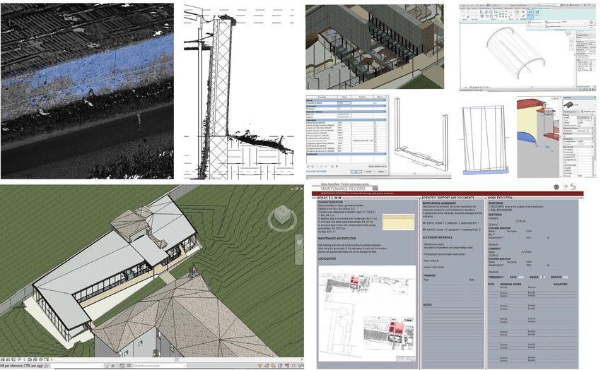
Figure 1: The design of the archaeological area next to the monastery of Santa Maria in Castiglione. The point cloud and the
extraction of profiles (top, left), the modelling stage of complex element (top right), the architectural design of the new
coverage (bottom, right) and the card for the planned conservation (bottom, left).
and photogrammetry, both terrestrial and from the drone, will be necessary. The federated model, a combined building
be the main topics. Together with them, we will focus on the information model that is compiled from several BIM models
survey project and, more precisely, on the need to establish a from different disciplines into one, will have to respond, starting
reliable and durable reference system (through a topographic from a single datum (the cloud of points) to the needs of
network), which is essential to deal with the documentation conservators, plant engineers, and structural designers.
phase but also for the construction site and subsequent
maintenance. The collaboration with instrument manufacturers
will be essential to offer participants the latest technologies 4. LESSON LEARNED FROM A PREVIOUS
(such as SLAM-based systems). Attention will also be drawn to EXPERIENCE
the relationship between precision, accuracy, object size, and
BIM objectives, which is necessary to correctly design the type The master designed by Politecnico di Milano for October 2020,
of documentation. and postponed to January 2021 for the coronavirus emergency,
The second part of the module dedicated to Geomatics is starts from another experience conducted in 2019. In May 2019,
certainly the most complex because it deals with issues that are in fact, Politecnico di Milano organized a training course, of
not completely solved even in research. The Scan2BIM process only 100 hours, to verify the general approach already designed
will be at the center of the lessons. We will analyze different for the HBIM master. We proposed a training course with a
procedures and methods, more or less automatic, for the structure similar to that of the master (three main design
construction of the parametric BIM models. Point clouds will be modules in addition to Geomatics) to a small number of
the most used data in this part, and, fortunately, it will be participants, ten recent graduates in architecture. The
possible to treat together both those obtained by extracurricular internship, foreseen as a fundamental part of the
photogrammetry and those obtained by laser scanner. course, allowed the 10 participants to develop the approach to
In addition, we will highlight some aspects for which there is no BIM systems applied to existing heritage in architectural
univocal answer yet, but which require instead to be addressed offices, engineering companies, and institutions for a total of
through broader and more structured reasoning. In fact, we will 500 hours each.
talk about the modeling phase and the precisions that can be The course was a good success: we received 24 applications
reached through parametric methods. For example, thanks to the from all over Italy, compared to the 10 open positions. But the
experiences brought by the co-presence of restorers, plant most significant numbers concern the job placement of
engineers, and structural designer, we will try to define the participants at the end of the course. Out of the eight trainees
characteristics of each model. For example, concerning the final (two retired for personal or professional reasons), 75% were
accuracy and the elements that cannot be missing, according to confirmed with other employment contracts at the societies
the purpose of the model. This issue recalls many aspects of the where they did their internship, while the other 25%, continue
BIM world such as the classification and segmentation of data their professional career with other companies operating in the
and the choice of LOD. Also on these issues, a comparison will BIM field.
This contribution has been peer-reviewed.
https://doi.org/10.5194/isprs-archives-XLIII-B5-2020-9-2020 | © Authors 2020. CC BY 4.0 License. 12The International Archives of the Photogrammetry, Remote Sensing and Spatial Information Sciences, Volume XLIII-B5-2020, 2020
XXIV ISPRS Congress (2020 edition)
Figure 2: structural intervention on the roof of the Basilica of San Luigi in Castiglione delle Stiviere. The scheme of the single truss
(top, left), the model of the roof with all the trusses and the linked photos (top, right), the entire model (bottom, left) and
the detail of the structural project for the roof (bottom, right).
These numbers have convinced the Politecnico to confirm the the position of the mosaics), and then designed the roof
training course in the HBIM field, but implementing it through structure. He was able to manage the data related to the
a new master of specialization (aimed at newly graduated excavations (point cloud, superintendence reports, surveys)
architects and engineers). Moreover, the same numbers have effectively. The last step concerned the conservation plan of the
shown that the labor market is looking for people who can archaeological excavations, with the construction of a schedule
manage HBIM systems with particular attention to the of controls and reports all linked to the BIM model (Figure 1).
digitization phase and to the data processing itself.
The internship experiences were carried out in engineering In contrast, in the Basilica of San Luigi, also in Castiglione
companies already operating in the HBIM field, but also in delle Stiviere, the theme of the project was the structural
architectural offices and institutions owning assets that saw the consolidation of the roof. Having at her disposal the point cloud
need to update their operating procedures. of the attic, the apprentice modeled all the trusses in BIM
In the first case, the apprentices were able to take part in the enviroment. To develop the model, she first studied the
BIM process, by entering a well-designed workflow: this historical construction technologies, then defined a family of
allowed them to appropriate experience and apply methods, trusses corresponding to the real one and, finally, modified each
under the guidance of specialized personnel. instance with the real measures extracted from the point cloud.
On the other hand, those who have done their internship in The documentation photos of the geometry and of the state of
institutions not yet specialized, had the opportunity to think and conservation were linked to the individual trusses to form a
design their BIM according to the needs of the work and the complete documentation apparatus. Even the structural
available data. Here we describe two cases of neo-architects interventions, designed by the structural engineer, have been
who worked for three months in the Diocese of Mantua with the included in the model as verification (Figure 2).
aim of designing and managing BIM in very different fields.
They were housed in the office that supervises relations
between the churches of the Diocese and the Superintendence 5. CONCLUSIONS
(that aims to protect the heritage). So the themes concerned
historical buildings and new projects connected to them. A training course for new graduates, organized by the
In the first case, the newly graduated architect dealt with the Politecnico di Milano in 2019, helped to demonstrate the
data of the monastery of Santa Maria in Castiglione delle demand of the labor market for expert figures in the field of
Stiviere, where the Diocese was planning a renovation project to BIM applied in the field of built heritage. The training
build a hotel for pilgrims. Mainly, the assignment concerned the curriculum will be proposed again in an extended form as a
design, in BIM mode, of a roofing system for the preservation master course starting in January 2021. Basically, the course is
of the remains of a Roman villa, which are located near the based on the integration of the main areas of architectural
monastery. The Diocese provided the BIM model of the main intervention (conservation, plant, and structural design) with a
building and the point cloud, made with laser scanner and drone geomatics module that is related to all the other areas mentioned
photogrammetry of the entire complex. The apprentice first above.
studied and represented the archaeological excavations, the In HBIM, Geomatics acquires fundamental importance because
position of the elements important for the design (floor level, it is involved not only in the data collection (metric data) but
This contribution has been peer-reviewed.
https://doi.org/10.5194/isprs-archives-XLIII-B5-2020-9-2020 | © Authors 2020. CC BY 4.0 License. 13The International Archives of the Photogrammetry, Remote Sensing and Spatial Information Sciences, Volume XLIII-B5-2020, 2020
XXIV ISPRS Congress (2020 edition)
also in its processing, from point cloud to the parametric model. 303–310, https://doi.org/10.5194/isprs-archives-XLII-2-W3-
Precisely in this passage, from BIM model to point cloud, we 303-2017, 2017.
find all the fundamental and characteristic elements of this
training path. Among them: the choice of instruments and the European Construction Sector Observatory, 2019. Building
project of the architectural survey, the modeling methods Information Modelling in the EU construction sector. Trend
(including segmentation), and the simplification of the model Paper Series. March 2019.
until obtaining the necessary LOD.
The training about all these topics is very important because in EU BIM Task group, 2018. Handbook for the introduction of
many cases, there are no absolute answers (even true o false), Building Information Modelling by the European Public Sector,
but it is necessary to put each problem in its own context. For available from: http://www.eubim.eu/, last access 30/04/2020.
example, it is not possible to state, in absolute terms, what the
precision of the model is. Still, it will be possible to define the
precision for a model made for structural or plant engineering Lopez F.J., Lerone P.M., Llamas J., Gomez-Garcia-Bermejo J,
purposes. Also, the modeling phases cannot be addressed only Zalama E, 2018. A Review of Heritage Building Information
from a geometric point of view (for example, the shape of a Modeling (H-BIM), in Multimodal Technologies and Interact.
barrel vault), but we should evaluate the planned interventions 2018, 2, 21; doi:10.3390/mti2020021.
and the information available and required.
These examples try to demonstrate the strong correlation Murphy, M., McGovern, E., Pavia, S., 2009. Historic building
between Geomatics and each kind of intervention in the HBIM information modelling (HBIM). Structural Survey 27 (4), 311–
process. This correlation is not simply a time order of 327.
operations: first, the survey, then the project and finally, the
construction site. On the contrary, it requires a continuous OICE, 2020, Rapporto sulle gare BIM 2019 per opere
exchange that can only be carried out by experienced and pubbliche, Analisi del mercato e delle gare, Rome, 2020, from:
trained personnel in the various sectors. https://www.oice.it/638197/rapporto-sulle-gare-bim-2019, last
access 30/04/2020.
ACKNOWLEDGMENTS
Panteli, C., Polycarpou, K., 1, Morsink-Georgalli, F. Z.,
We would like to thank all the participants of the training course Stasiuliene, L., Pupeikis, D., Jurelionis, A., Fokaides, A.,
for sharing opinions, requests and suggestions regarding the 2020. Overview of BIM integration into the Construction
topics of HBIM. We would like to thank in particular the Sector in European Member States and European Union Acquis.
Diocese of Mantua and recent graduates Barbara Fazion and IOP Conference Series: Earth Environment Science 410
Damiano Del Posso for sharing the materials of their internship. 012073.
REFERENCES Pavan A., Mirarchi C., Dalila C., De Gregorio M., 2020,
Standard BIM, il mondo dopo la ISO 19650, from
Adami A., Scala B., Spezzoni A., 2017. Modelling and accuracy https://www.ingenio-web.it/26765-standard-bim-il-mondo-
in a BIM environment for planned conservation: The apartment dopo-la-iso-19650, last access 30/04/2020.
of Troia of Giulio Romano. Int. Arch. Photogramm. Remote
Sens. Spatial Inf. Sci. 2017, XLII-2/W3, 17–23.
Adami A., Fregonese, L., Rosignoli, O., Scala, B., Taffurelli, L.,
and Treccani, D. 2019. Geometric survey data and historical
sources interpretation for HBIM process: the case of Mantua
cathedral façade, Int. Arch. Photogramm. Remote Sens. Spatial
Inf. Sci., XLII-2/W11, 29–35, https://doi.org/10.5194/isprs-
archives-XLII-2-W11-29-2019, 2019.
Adami A., Bruno N., Rosignoli O., Scala B., 2018. HBIM for
planned conservation: A new approach to information
management. In Proceedings of the Visual Heritage 2018,
Vienna, Austria, 12–15 November 2018.
Banfi F. (2019). HBIM generation: extending geometric
primitives and BIM modelling tools for heritage structures and
complex vaulted systems. International Archives of the
Photogrammetry, Remote Sensing and Spatial Information
Sciences, XLII-2/W15, 139–148. https://doi.org/10.5194/isprs-
archives-XLII-2-W15-139-2019.
Bruno N., Roncella R., 2019, HBIM for Conservation: A New
Proposal for Information Modeling. Remote Sens. 2019, 11,
1751; doi:10.3390/rs111517514.
Fregonese, L., Taffurelli, L., Adami, A., Chiarini, S.,
Cremonesi, S., Helder, J., and Spezzoni, A., 2017. Survey and
modelling for the BIM of Basilica of San Marco in Venice, Int.
Arch. Photogramm. Remote Sens. Spatial Inf. Sci., XLII-2/W3,
This contribution has been peer-reviewed.
https://doi.org/10.5194/isprs-archives-XLIII-B5-2020-9-2020 | © Authors 2020. CC BY 4.0 License. 14You can also read