HBIM METHODOLOGY AS A BRIDGE BETWEEN ITALY AND ARGENTINA
←
→
Page content transcription
If your browser does not render page correctly, please read the page content below
The International Archives of the Photogrammetry, Remote Sensing and Spatial Information Sciences, Volume XLII-2, 2018
               ISPRS TC II Mid-term Symposium “Towards Photogrammetry 2020”, 4–7 June 2018, Riva del Garda, Italy

       HBIM METHODOLOGY AS A BRIDGE BETWEEN ITALY AND ARGENTINA

                                           A. Moreira a, R. Quattrini b, *, G. Maggiolo a, R. Mammoli b

              Faculty of Architecture, Design and Urbanism, National University of the Litoral, Santa FE, Argentina
               a

                                    amoreira@fadu.unl.edu.ar, gastonmaggiolo@gmail.com
       b DICEA, Dept. of Civil and Building Engineering and Architecture, Polytechnic University of Marche, Ancona, Italy

                                        r.quattrini@univpm.it, r.mammoli@pm.univpm.it

                                                       Commission II, WG II/8

KEY WORDS: Semantic Modelling, Built Memory, Parametric Intelligence, Reality Based Modelling, Ontologies

ABSTRACT:

The availability of efficient HBIM workflows could represent a very important change towards a more efficient management of the
historical real estate. The present work shows how to obtain accurate and reliable information of heritage buildings through reality
capture and 3D modelling to support restoration purposes or knowledge-based applications. Two cases studies metaphorically joint
Italy with Argentina. The research article explains the workflows applied at the Palazzo Ferretti at Ancona and the Manzana
Histórica de la Universidad National del Litoral, providing a constructive comparison and blending technological and theoretical
approaches. In a bottom-up process, the assessment of two cases study validates a workflow allowing the achievement of a useful
and proper data enrichment of each HBIM model. Another key aspect is the Level of Development (LOD) evaluation of both
models: different ranges and scales are defined in America (100-500) and in Italy (A-G), nevertheless is possible to obtain standard
shared procedures, enabling facilitation of HBIM development and diffusion in operating workflows.

                    1. INTRODUCTION                                   Thus, the strength of our work is the blending between a
                                                                      technological and a theoretical approach with reciprocal
The historical heritage in South America, as well as in Europe,       benefits. As in Argentina the lack of technological instruments
is now demanding robust procedures for obtaining Heritage             is a limitation, the need to wisely fill the gap with alternative
Building Information Modelling (HBIM) fully interoperable             sources and conceive a scalable HBIM approach is mandatory.
and rich in its informative content. The availability of efficient    In order to achieve that, it seems appropriate to work under the
workflows for engineers and architects could represent a very         realm of technology transfer as a system that defines and
important change towards a more efficient management of the           integrates purposes and practices. As well as, to work in a
historical real estate. The present work shows how to obtain          manner that provides the necessary tools to promote, capture
accurate and reliable information of heritage buildings through       and disseminate the intellectual capital (information) of an
reality capture and 3D modelling to support restoration               entire organization, enabling the classification and
purposes or knowledge-based application.                              dissemination of tacit and explicit knowhow for the
                                                                      development of projects. One of the most relevant
Today, two cases of study metaphorically joint Italy with             characteristics that demand its inclusion in the practice of
Argentina. The present research article explains the workflows        HBIM as a link between knowledge and needs is historicathat it
applied at the Palazzo Ferretti at Ancona and the Manzana             allows to make a parallel between the knowledge of "know how
Histórica de la Universidad National del Litoral (MHUNL),             to do things" and “why we do things".
providing a constructive comparison from which it is possible         Traditionally, all the information related to heritage buildings
to generalize a robust method for HBIM data management. In            has been represented by a collection of individual documents:
last years, several researches have been able to develop methods      original and non-original, official and unofficial drawings and
demonstrating the feasibility of a whole Building Information         surveys, bi-dimensional representations either hand or computer
Modelling (BIM) approach for complex architectural shapes             assisted drawings. These datasets were generated by different
starting from point clouds. As result of this implementations,        professionals, following their own methodologies, personal
interesting developments arise when it is possible to work in 3D      investigations, tools and standards. This information is
environment along the process to minimize the steps and format        dispersed in various locations meaning that there are miles
changes during the modelling and enrichment phases in order to        between the documentation and the object, resulting in a total
avoid simplification or loss information. In this line, a focus is    disconnection between the information, the building and the
to achieve a good procedure able to overcome the challenge of         people responsible for its operation and management. We must
creating BIM models to be used in cultural heritage.                  also highlight the status and quality of this information, which
Beginning from 2D drawings and 3D point cloud at high                 is generally unknown; it may have been replaced,
resolution, HBIM methodology could become a bridge of                 uncoordinated, or incomplete. In most cases, in Argentina but
technology transfer that allows a complete management of              not only, there is no single source of reliable and consistent
future architectural and restoration project.                         information about a heritage asset in particular.

* Corresponding author

                                               This contribution has been peer-reviewed.
                     https://doi.org/10.5194/isprs-archives-XLII-2-715-2018 | © Authors 2018. CC BY 4.0 License.                   715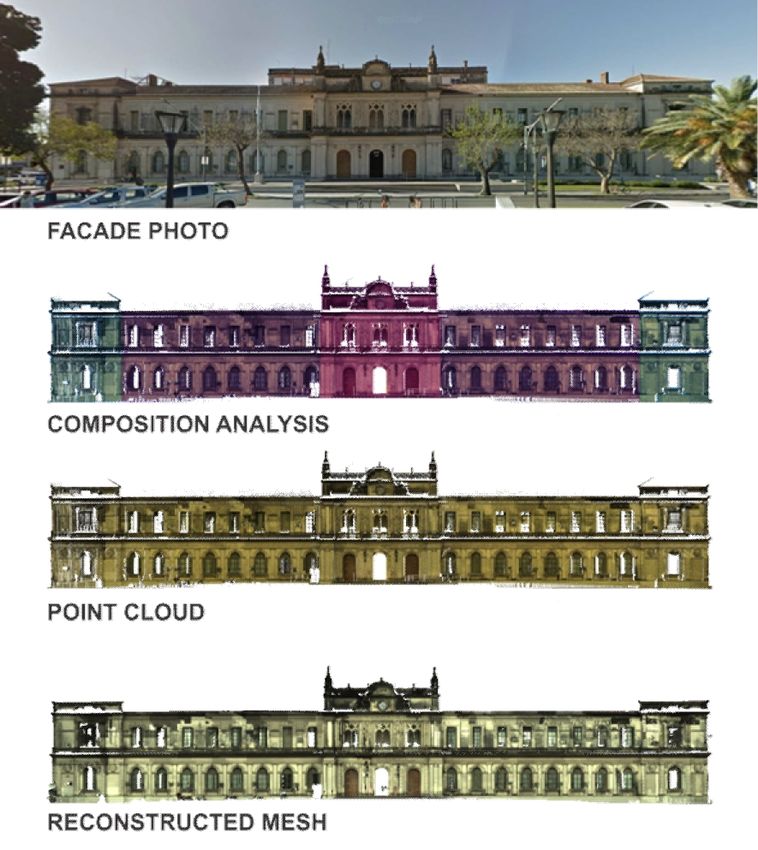
The International Archives of the Photogrammetry, Remote Sensing and Spatial Information Sciences, Volume XLII-2, 2018
               ISPRS TC II Mid-term Symposium “Towards Photogrammetry 2020”, 4–7 June 2018, Riva del Garda, Italy

                     2. STATE OF ART                                  mapping the information with great accuracy on 3D models;
                                                                      complex queries to retrieve all of the information easily
Recently, BIM and its related digital innovations have                (Apollonio et al., 2018).
demonstrated to be a catalyst for more transparency, tighter
integration, and increased productivity in the architecture,                   3. TWO PIPELINES IN COMPARISON
engineering, and construction industry (AEC). This technology
transfer should be exploited and scaled up as a digital disruption    Considering previous highlighted advances in HBIM modelling,
(Merschbrock and Munkvold, 2015). Technology transfer does            but also the lack of solutions to be extended to all cases and
not refer to a connection of a machine with other machines and        purposes of interventions, the paper shows two similar and
has nothing to do with a specific technology -it is not a             complementary approaches with the goal of building up a solid
computer or a laser beam. The concept involves the                    workflow for reality-based models sufficiently rich of
"transformation of available socio-technological resources, such      information and semantically structured. Weak and strong
as skills and tools, into solutions” (Schreyer, 2001). It should be   points of two workflows are also discussed and authors provide
noted that the acquisition of technologies does not necessarily       a comparison allowing to establish a concrete path in HBIM
lead to the acquisition of knowledge, nor the technological           field.
capacity to operate it. Instead, it provides dynamic knowledge,
which generates a combined structure between knowledge and            3.1 The Palazzo Ferretti’s case study
the infrastructure that makes possible to cope with any type of
conditionings. This joining extends the scope of the process for      In regards to Palazzo Ferretti, the procedure allows to build a
the development of projects, covering legal terms, techniques,        parametric model of this building in a Revit environment
management and manufacture (Davenport and Prusak, 2000).              integrating several sources: Terrestrial Laser Scanner (TLS)
The difference between BIM and HBIM derives mainly from               survey served as main reference and for the correction of
their goal: it is clear that HBIM as design tool should be an         previous two-dimensional surveys, on the other hand
informative system able to define the state of conservation and       photogrammetric survey was carried out for detailed
planning future operations, along all the life-cycle of               information, in comparison with treatises recommendations
architectural heritage. More in general, literature shows             (Figure1). A global information management provides a HBIM
differences both from the process point of view both from the         fully interoperable and with sufficient descriptive information
conceptual scheme. Major challenges in HBIM diffusion are in          for both the building and the intended use of this one, i.e. a
the need of extending processes for as-planned building to as-        museum. Today, in fact, the Palace is the location of National
built models (Volk et al., 2014). In addition, HBIM approach          Archaeological Museum of Marche Region.
needs to face theoretical and pratical challenges and to fill gap
regard the BIM: a wide discussion about differences between a)
semantic object or unsegmented geometries, b) standardization
or irregularity c) parametric intelligence or geometric accuracy
is provided in (Apollonio et al., 2016). In HBIM field, the
modelling phase and the semantic sub-division in various
elements are sufficiently robust, although time-consuming
(Garagnani and Manferdini, 2013) (Barazzetti et al., 2015) and
based on proprietary tools .
According several studies, the observed trend in the definition
of HBIM is the creation of a model starting from survey data
(i.e. Terrestrial Laser Scanning (TLS), digital photogrammetry
etc.), aimed at the creation of a library of parametrical objects,
combined with the informative data in order to enrich the object
besides the modelling phase (Quattrini et al., 2017). Moreover,
highlighting the difference between modelling environment and
real informed approach, a major challenge nowadays is to
obtain a rich model usable in specific context. The final product
of the HBIM process should be a model that, before being used
as a professional tool, must be populated by non-geometrical
data for making it suitable for engineering and conservation               Figure 1. General workflow used for Palazzo Ferretti
applications. The LOD is not only the graphical quality of the
element but also the awareness about its characteristics,             Palazzo Ferretti was built in 1560 by Pellegrino Tibaldi with
following       the      AIA      definition     and      protocols   drawings provided by the great architect Antonio da Sangallo il
(“https://www.aiacontracts.org/contract-documents/19016-              Giovane. In a first step, we assumed to follow the same
project-bim-protocol,” n.d.). The UNI committee partially             modelling procedure applied to the previous cases (Quattrini et
updated these definitions, overcoming the GRADE by the LOG.           al., 2015): this is a 3D cloud environment managed without
In (COMMITTE, 2017) it is significant the introduction of a           proprietary licenses for the point cloud formats. However, for
specific LOD scale (F-G) for restoration.                             the entire extension of the building we were forced to use two-
The majority of the approaches provides desktop solutions, but        dimensional drawings. Despite the considerable amount of data
the adoption of web-based and 3D-centered informative system          collected, the TLS campaign did not cover all wings of the
have to be mentioned as challenging and promising                     Palace: 49 stations from the outside of the building and 20
development. Indeed these tools have several advantages; for          stations from inside. The modelling in Revit environment
example: several accesses by users from different locations at        highlighted some complexity especially in the case of not
the same time; central storage for the whole documentation; no        perfectly orthogonal walls and in the need to define a several
need of local application using WebGL graphic libraries;              vertical reference planes (Figure 2).

                                                This contribution has been peer-reviewed.
                      https://doi.org/10.5194/isprs-archives-XLII-2-715-2018 | © Authors 2018. CC BY 4.0 License.                 716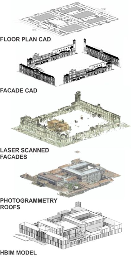
The International Archives of the Photogrammetry, Remote Sensing and Spatial Information Sciences, Volume XLII-2, 2018
ISPRS TC II Mid-term Symposium “Towards Photogrammetry 2020”, 4–7 June 2018, Riva del Garda, Italy
Figure 4. Semantic structure of a loadable family: bottom – up
link from basic elements to *.rfa file.
The coherence within HBIM model and all sources was also
assured by several documentation stages: for example an
interesting step was the comparison between orthophotos from
TLS point cloud and Structure from Motion (SfM) acquisition
Figure 2. Palazzo Ferretti: from cad to TLS and HBIM model (Figure 5).
Specifically, in this paper the case study aims to validate a
workflow able to handle all the information available in a
hierarchically managed database using ontologies and
taxonomies. This could be useful for readers if compared with
the following case study. These ontologies and taxonomies
represent the structuring of the data themselves and starting
from some defined datasets they are linked to the three-
dimensional model in different ways. In the case of Palazzo
Ferretti, we not only implemented datasets that represented
composition and architectural elements of the building, but also
other ones suitable for the description of Palazzo Ferretti as an
art gallery. For this goal, a specific data enrichment was
performed through Revit and using the shared parameters: we
added to HBIM the archaeological evidences as specific
Figure 3. HBIM of Palazzo Ferretti, main façade: individuation instances referred to 3D models (with external or encapsulated
of loadable families. In green the windows and in brown links) and historical data.
monumental entrances Once the modelling of Palazzo Ferretti was completed, to
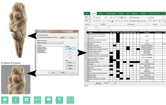
enable a more complete and exhaustive data enrichment, we
created families to identify various archaeological evidences in
However, the major phase has involved the moldings of main
rooms of the Museum. The realization of loadable families,
façades with the realization of loadable families (*.rfa) for
renamed "Archaeological Find" has gone through the creation
which semantics and geometric constraints have been studied
of a generic cylindrical shape in order to ideally identify the
coherently with the practice of building and with the rules of the
finds within the modeled space. Once the "Archaeological Find"
treaties. In fact, at this stage, the most significant results for
family has been obtained, this has been loaded into Palazzo
Palazzo Ferretti concern the realization of parametric libraries
Ferretti project through the "Family Editor" section.
for the external and internal building moldings.
Created parameters, linked to different thematic areas, could
All the windows, the door frames and boss, the triumphant
give different type of information referred on each single find:
balcony and all frames have been defined, with their basic
text, url and image (pdf 3D) (Figure 6).
elements and semantically connected thanks to the
Another following step regarded the question of
nomenclature of the parties and to the inherent structure in
interoperability. After having structured and made the
Revit (Figure 3). This is a robust nucleus of a typical ontology
connection between the model and the database we decided to
for a Renaissance building at different LOD (Figure 4).
carry out an export in ISO .ifc format. The choice of this format
This contribution has been peer-reviewed.
https://doi.org/10.5194/isprs-archives-XLII-2-715-2018 | © Authors 2018. CC BY 4.0 License. 717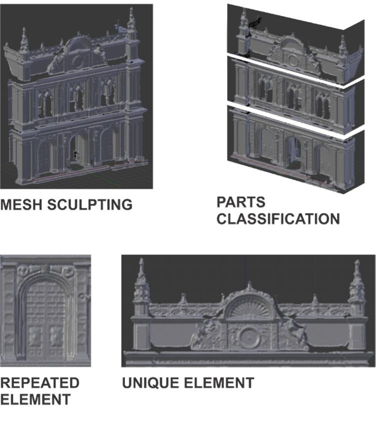
The International Archives of the Photogrammetry, Remote Sensing and Spatial Information Sciences, Volume XLII-2, 2018
ISPRS TC II Mid-term Symposium “Towards Photogrammetry 2020”, 4–7 June 2018, Riva del Garda, Italy
situation makes the access to the documentation difficult, also
increases the time of research and causes errors in the decision
making process. The current state of the information is the main
cause of improper maintenance and incorrect protocols of
preservation and restorations or modifications.
The implementation of several technological innovations has
produced a series of new methodological and instrumental
resources, which began to provide potential answers to the
problem of the lack of information about the built environment
related to cultural heritage.
This work describes a possible alternative for the creation and
development of an information system that combines multi-
dimensional data as shown in this case study (Figure 7). Aware
that every heritage building has its own location characteristics
and constructive architectural features that makes each one
unique, it is necessary to find different strategies customized to
the building under study; particular situations that determine the
type of operations to be performed. (Figure 8).
To achieve a proper HBIM process we had the operational need
to carry out a protocol that allows us to obtain a rapid
assessment of the state of a heritage building in an efficient
manner. This protocol is based in the APGAR1 score, a method
to quickly summarize a concrete situation with multiples crosses
of information and great uncertainty. We chose six common
parameters to evaluate all heritage buildings; having into
account that they are the most determining parameters to plan a
Figure 5. Comparison between orthophotos: TLS and SfM work process related to the analysis of the buildings.
seems the most logical considering that it is supported by many
software available on the market.
After the export to IFC we checked the maintenance of the data
structure and the compatibility with other descriptors. This will
allow us to evaluate the interoperability and the ontological
accuracy of the model exporting to IFC format and analyzing
the output file to detect inconsistencies or data loss when
moving from different work environments.
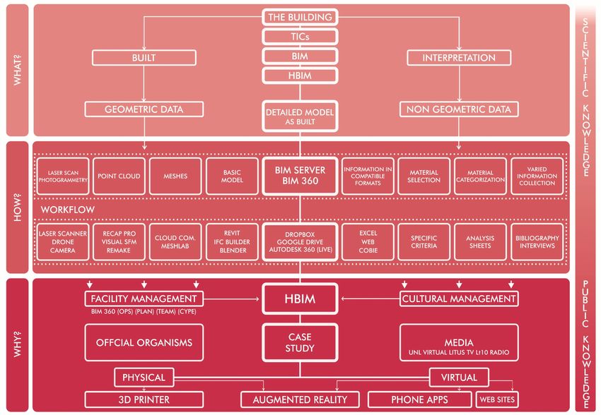
Figure 7. HBIM conceptual scheme
These parameters are evaluated based on a score table that
values between 0 and 2; adding the sum of each parameter, we
obtain the total valuation of the building under study. The range
of assessment oscillates between 0 and 10 points, defining the
maximum value obtained as the most favorable state of
situation.
Figure 6. Shared parameters and information extracted for the
archaeological evidence “La Venere di Frasassi”
1 Lichtig, Will. Projects as Patients. What can we learn from the
3.2 La Manzana Histórica de la Universidad Nacional del medical profession?. Will Lichtig. The American Institute of Architects,
Litoral (MHUNL) 2004. A Joint Project of AIA California Council Integrated Project
Delivery Steering Committee AIA National Integrated Practice
“El edificio de la Manzana Histórica” of Universidad Nacional Discussion Group”. Research and report by Jonathan Cohen, FAIA
del Litoral is recently named National Historical Monument in For more detailed background information on IPD, visit www.ipd-
Argentina because it was the first building for a public ca.net and refer to The Integrated Project Delivery Guide, jointly
university in the whole country. The HBIM methodology was developed by the AIA’s Integrated Practice Discussion Group and AIA
considered as a potential solution to its update, upgrade and California Council, and Integrated Project Delivery: A Working
Definition, published by AIA California Council.
valorisation. In Argentina, the main problem is that all the
For information on existing project delivery methods, see the AIACC’s
information is made up by a collection of individual and Handbook on Project Delivery. More information can be read here:
disconnected documents, dispersed in different places. This https://www.newyorker.com/magazine/2006/10/09/the-score
This contribution has been peer-reviewed.
https://doi.org/10.5194/isprs-archives-XLII-2-715-2018 | © Authors 2018. CC BY 4.0 License. 718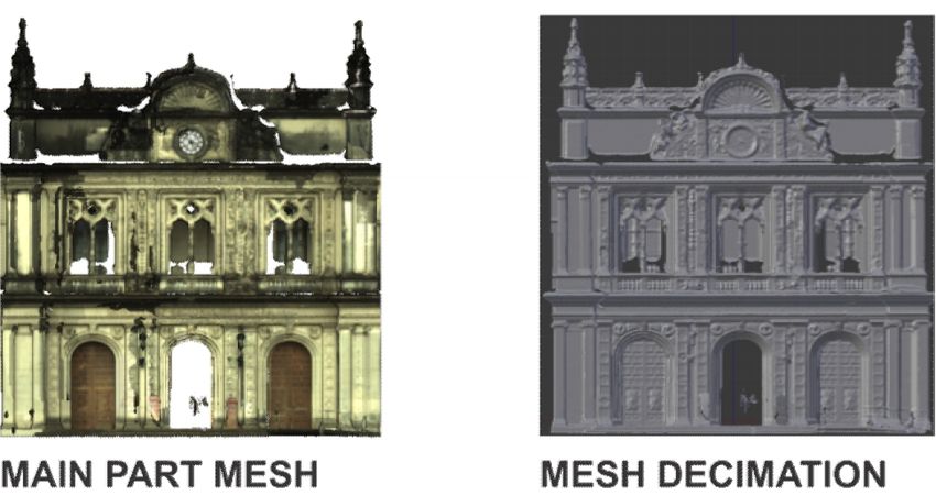
The International Archives of the Photogrammetry, Remote Sensing and Spatial Information Sciences, Volume XLII-2, 2018
               ISPRS TC II Mid-term Symposium “Towards Photogrammetry 2020”, 4–7 June 2018, Riva del Garda, Italy

In the case of MHUNL we got a score that allowed us to have a
picture of the present situation and helped us to establish a
proper path of activities to go along with the tasks we need to
perform in the future. Although we had good sets of information
about the architectural language and the construction system
used in this building, but we do not have yet a trustable
technical database. This protocol as tool of diagnosis allowed us
to discover the main obstacles present at the location of the
building, which helped us to plan the survey also anticipate
possible future problems (Figure 9). Once determined the real
situation of MHUNL, we were able to plan a photogrammetric
and laser scanning survey only from the outside of the building,                        Figure 8. Situation Table
according to a general workflow (Figure 10).

Several technological equipment were used: a Leica C10 laser
scanner for 12 scans of the exterior of the building; a drone Dji
Inspire One Pro to obtain more accurate information of the top
parts of the building and a digital camera Nikon 7500 to take
photos of ornaments and specific decorations. Even though we
do not have our own equipment or the necessary money to carry
out this type of activities; we were able to perform a
comprehensive survey campaign adequate to our possibilities,
sharpening our critical thinking and management capacity to
awaken the interest of local companies that helped us to go
ahead with this endeavor (Figure 11).
The recognition that we are short of data to make a complete
and accurate model of the entire building (Figure 12, Figure
13), push us to have a thinking strategy for decision making that
harmonizes tradition and innovations. By streamlining the data
obtained from different sources, grants us to lay the foundations
of a work process based on broader view of HBIM
methodologies, customized to a specific work environment as
new method to manage multidimensional information
efficiently.                                                            Figure 9. Protocol Table for Manzana Histórica Building.

                                Figure 10. General workflow: from the analysis to HBIM final model

                                               This contribution has been peer-reviewed.
                     https://doi.org/10.5194/isprs-archives-XLII-2-715-2018 | © Authors 2018. CC BY 4.0 License.               719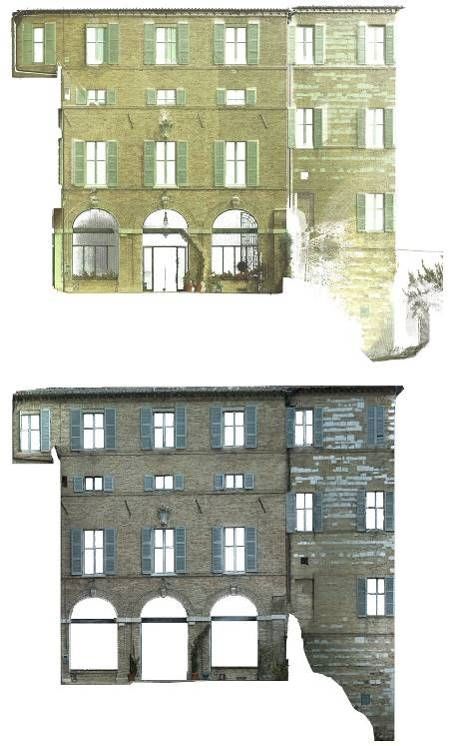
The International Archives of the Photogrammetry, Remote Sensing and Spatial Information Sciences, Volume XLII-2, 2018
              ISPRS TC II Mid-term Symposium “Towards Photogrammetry 2020”, 4–7 June 2018, Riva del Garda, Italy

                Figure 11. Phases of the work

                                                                    Figure 13. Workflow and mesh treatment of a part of Manzana
                                                                                       Histórica main façade

                                                                                 4. DISCUSSION AND RESULTS

                                                                   The comparison between the works presented here makes it
                                                                   possible to understand the effectiveness and the necessity of
                                                                   dissemination of suitable HBIMs, obtained by using appropriate
                                                                   research and conservation analysis tools. The use of different
                                                                   datasets, which orient the link between model and information,
                                                                   allows to represent and supply large quantities of specialized
                                                                   information for the knowledge of the historical heritage.
                                                                   The main goal of the presented work is to focus on the potential
                                                                   solutions offered by the use of today information models,
                                                                   generated through the application of technological innovations
                                                                   tools that allows to capture the built environment. Achieving it
                                                                   will not only demonstrate the lack of precision of the
Figure 12 Phases to obtain ad accurate model: photogrammetric      documentation obtained through surveys based on traditional
   acquisition, façade composition analysis, point cloud and       methods, also the potentiality of accessibility and the ability to
           reconstructed mesh of Manzana Histórica

                                              This contribution has been peer-reviewed.
                    https://doi.org/10.5194/isprs-archives-XLII-2-715-2018 | © Authors 2018. CC BY 4.0 License.                  720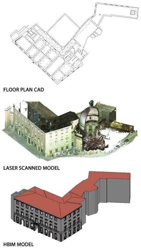
The International Archives of the Photogrammetry, Remote Sensing and Spatial Information Sciences, Volume XLII-2, 2018
               ISPRS TC II Mid-term Symposium “Towards Photogrammetry 2020”, 4–7 June 2018, Riva del Garda, Italy

incorporate information in a multidimensional digital model          scale (Palazzo Ferretti) and to the LOD 500, used in heritage
(Figure 14).                                                         rehabilitation and maintenance projects for the Manzana
The importance of this proposal is the recognition of the            Histórica. The elements of the models are represented in their
relevant role that the administration, the organization and access   entirety and have been associated with graphical and non-
to information are the main challenges in the processes of           graphical information like technical documentation, such as
conservation, restoration and maintenance of heritage buildings      floor plans, sections, elevations and details or external links.
(Figure 15).
The results obtained from the actual application of this
methodology on the building of MHUNL are also discussed,
and the implication of the application of this method, not only
will allow the continuous incorporation of new information
regarding the building, but also its permanent feedback and
updating. The diffusion of similar practices could guarantee
instantaneous accessibility through different types of electronic
devices, and their preservation in an organized and hierarchical
manner.

Another key aspect to be discussed is about LOD: obtaining
standard shared procedures could facilitate HBIM development
and diffusion in operating workflows. Interesting results arose
from the evaluation of the different definitions, ranges and
scales for LOD in America (100-500) and in Italy (A-G), also
considering that the recently released UNI 11337 is expected to
be scaled up at European level. Semantically structured data
(ontologies) in both models allowed a complete management of               Figure 14. Comparison between current and HBIM
the repositories and the dissemination of the methodology                              management of the model
permit to validate the quality of the different levels of detail -
definition. Both BIM models are reliable as - built,
corresponding respectively to the F grade, i.e. the restoration

                                          Figure 15. From a scientific to a public knowledge

                                               This contribution has been peer-reviewed.
                     https://doi.org/10.5194/isprs-archives-XLII-2-715-2018 | © Authors 2018. CC BY 4.0 License.                 721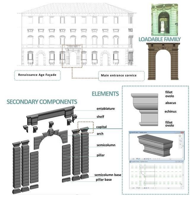
The International Archives of the Photogrammetry, Remote Sensing and Spatial Information Sciences, Volume XLII-2, 2018
               ISPRS TC II Mid-term Symposium “Towards Photogrammetry 2020”, 4–7 June 2018, Riva del Garda, Italy

                     5. CONCLUSIONS                                 https://doi.org/10.1016/J.CULHER.2017.07.010

The analysis and assessment of the two presented procedures         Apollonio, F.I., Gaiani, M., Sun, Z., 2016. A Reality Integrated
constitute a proper inquiry to enable the method extension to all   BIM for Architectural Heritage Conservation. Handb. Res.
historical buildings. Major challenges were expected in             Emerg. Technol. Archit. Archaeol. Herit. 31.
elimination of all those steps that cause lose efficiency and
precision, but now we are able to observe that specific and         Barazzetti, L., Banfi, F., Brumana, R., Previtali, M., 2015.
useful improvements arise only merging theoretical and              Creation of Parametric BIM Objects from Point Clouds Using
technical approaches.                                               Nurbs. Photogramm. Rec. 30, 339–362.
We are able to conclude that the comparison between the cases
study can validate a workflow that allow achieving a useful and     COMMITTE, U., 2017. UNI 11337-4:2017 Edilizia e opere di
proper data enrichment of each HBIM model. This is possible         ingegneria civile - Gestione digitale dei processi informativi
by implementing a database of functional metadata for an easy       delle costruzioni - Parte 4: Evoluzione e sviluppo informativo
management and usability in Revit environment and in                di modelli, elaborati e oggetti.
technical-professional context. The model separates itself from
its canonical definition of simple representation, becoming a       Davenport, T.H., Prusak, L., 2000. Working knowledge.
container of information, more or less useful. The flexibility of   Ubiquity 2000, 2–es. https://doi.org/10.1145/347634.348775
used methodology also allows to implement the model making          Garagnani, S., Manferdini, A.M., 2013. Parametric accuracy:
it available at any time, with the opportunity to modify it by      Building Information Modeling process applied to the cultural
adding information. The model will be able to extend its            heritage preservation, in: 3DArch2013, Conference Proceedings
knowledge and receive constant updates over time.                   of The International Archives of the Photogrammetry, Remote
                                                                    Sensing and Spatial Information Sciences, Trento, Italy.
                                                                    Citeseer, pp. 87–92.
                 ACKNOWLEDGEMENTS
                                                                    https://www.aiacontracts.org/contract-documents/19016-
                                                                    project-bim-protocol [WWW Document], n.d.
The authors want to acknowledge Nicoletta Frapiccini, the
director of Palazzo Feretti’s Gallery, and Prof. Paolo Clini for
                                                                    Merschbrock, C., Munkvold, B.E., 2015. Effective digital
allowing the use of data survey. The acquisition phase was
                                                                    collaboration in the construction industry – A case study of
performed under its supervision by Romina Nespeca, Ludovico
                                                                    BIM deployment in a hospital construction project. Comput.
Ruggeri and technicians of Dicea Department. The modelling
                                                                    Ind. 73, 1–7. https://doi.org/10.1016/J.COMPIND.2015.07.003
phase of Palazzo Ferretti was carried out in training and degree
thesis by Fides Carosi, Valentina Carducci, Vincenzo Danzi,
                                                                    Quattrini, R., Malinverni, E.S., Clini, P., Nespeca, R., Orlietti,
Marco Mattioli e Maria Laura Pierpaoli, relator Prof. Ramona
                                                                    E., 2015. From tls to hbim. high quality semantically-aware 3d
Quattrini at the Polytechnic University of Marche.
                                                                    modeling of complex architecture, in: International Archives of
                                                                    the Photogrammetry, Remote Sensing and Spatial Information
The HBIM model of Manzana Histórica was performed by the            Sciences - ISPRS Archives.
students Maggiolo Gaston, Cristaldo German, Bernal Roberto,         https://doi.org/10.5194/isprsarchives-XL-5-W4-367-2015
Ocampo Alejandra, who are completing their final career work
in the Faculty of Architecture, Design and Urbanism of the          Quattrini, R., Pierdicca, R., Morbidoni, C., 2017. Knowledge-
National University of the Litoral Santa FE, Argentina. This        based data enrichment for HBIM: Exploring high-quality
case study is directed by Mg. Arq. Alejandro Moreira, Dr. Arq.      models using the semantic-web. J. Cult. Herit. 28.
Cecilia Parera.                                                     https://doi.org/10.1016/j.culher.2017.05.004

                        REFERENCES                                  Schreyer, P., 2001. The OECD Productivity Manual: A Guide
                                                                    to the Measurement of Industry-Level and Aggregate
Apollonio, F.I., Basilissi, V., Callieri, M., Dellepiane, M.,       Productivity. Int. Product. Monit. 2, 37–51.
Gaiani, M., Ponchio, F., Rizzo, F., Rubino, A.R., Scopigno, R.,
Sobra’, G., 2018. A 3D-centered information system for the          Volk, R., Stengel, J., Schultmann, F., 2014. Building
documentation of a complex restoration intervention. J. Cult.       Information Modeling (BIM) for existing buildings—Literature
Herit.                       29,                        89–99.      review and future needs. Autom. Constr. 38, 109–127.

                                               This contribution has been peer-reviewed.
                     https://doi.org/10.5194/isprs-archives-XLII-2-715-2018 | © Authors 2018. CC BY 4.0 License.                   722
You can also read