Weather Information Management in Major Construction Projects: State of the Technology
←
→
Page content transcription
If your browser does not render page correctly, please read the page content below
The 54th International Conference of the Architectural Science Association (ANZAScA) 2020

             Weather Information Management in Major Construction
                        Projects: State of the Technology

                                                       Andrea Y. Jia1
                       1
                           Graduate School of Higher Education, University of Melbourne, Australia
                                               andreayunyanjia@gmail.com

       Abstract: This paper presents a brief review of the state of the technology for managing weather
       information, with a specific focus on heat stress in major construction projects. Recent technologies of
       monitoring, referencing, recording and managing heat stress risks are reviewed against their relevance to
       the project management practice with an aim to identify gaps and potentials for process innovation. The
       findings suggest the state of the relevant technology is largely serving a top-down, efficiency-driven
       decision process. However, planners at the top do not have the complete information of the context
       against which their decisions are being implemented and tested out. The rich information of the work
       context owned by the frontline operational people, in this case, the nature of the diverse work activities
       embedded in the diverse geospatial characteristics of the workplaces on construction site, is not being
       fully values and engaged in the current practice. The review suggests a dual-level weather information
       management system: engage and empower local actors for personal risk mitigation; tighten inter- project
       coupling to pool the data for future weather-wise project planning. The challenge with system design is
       how to register the complex spatial characteristics in the workplaces on construction site; how to put
       feasible and low-cost sensors to capture and transmit the needed data, including radiant heat and air
       velocity. This study contributes to a solution-oriented bottom-up approach to weather information
       management in major construction projects.

       Keywords: heat stress; BIM; georeferencing; weather information management, major projects.

       1. Introduction
       In a recent Work Health and Safety brief, Work Safe Australia identified 1 235 workers’ compensation
       claims related to working in heat during 2008 to 2018. In New South Wales, a cost of $7 million was
       attributed to workers’ compensation claims for cases of heat stroke, fatigue and skin cancer (SIA, 2016).
       Heat stress is particularly hazardous to construction workers because on-site work activities are defined
       and controlled by many administrative and psychosocial factors embedded in the team culture, project
       organizing structure, the procurement system and the sociopolitical dynamics among key stakeholders
       (e.g. Jia et al, 2016a, 2018, 2019, 2020). Different sizes of construction projects are faced with different
       challenges: major projects can have a supervisor to worker ratio of up to 1:40, making it difficult to
       materialise management decisions as they were proposed. Small projects find their challenges in lack of

              Imaginable Futures: Design Thinking, and the Scientific Method. 54th International Conference of the
              Architectural Science Association 2020, Ali Ghaffarianhoseini, et al (eds), pp. 1370–1379. © 2020 and
              published by the Architectural Science Association (ANZAScA).

1370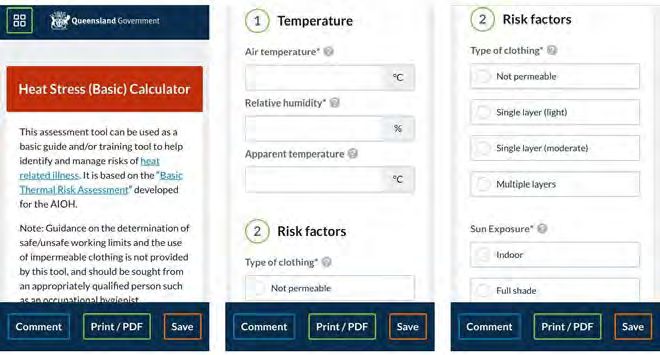
Andrea Y. Jia

resource, unaffordability of personnel upskilling and reskilling, and the lack of information and tools
(Loosemore & Andonakis, 2007). However, small projects and firms have a much higher supervisor to
worker rate, as much as 1:2 as the author observed on residential building sites in Queensland, where
heat stress can be managed through a personal and flexible approach. In major projects, a formal and
standardised system is needed to ensure risks are systematically managed and future projects learn from
existing experience. This study aims to review the state of the technology on monitoring, referencing and
managing heat stress information for major construction project management, based on which identifies
gaps and potentials to envision a participatory approach to weather information management in major
projects.

2. State of the technology
2.1. Weather information in project planning
In construction project management, weather-related factors such as heat stress have been discussed as
one of the leading factors that cause project delay, but is not legitimated as a reason for granting project
extension due to a lack of accurate estimation of weather’s impact on productivity loss (Assaf and Al- Hejji,
2006; Jung, et al, 2016). Thorp and Karan (2008: 816) note that ‘although weather delays are typical of
the so-called “act of God” type of delay, normal weather is not justification for the granting of an extension
of time. Most general conditions of contract state specifically that only adverse weather conditions that
cannot be reasonably anticipated would qualify as a basis for time extension.’
      Tian and de Wilde (2011) suggest to differentiate between foreseeable and unforeseeable weathers
in climate projection modelling. Ballesteros-Pérez et al. (2017) report a case study of estimating weather’s
impact on productivity in a RC building project and an SS building project. In their finding, productivity
varies with location and season, so is project duration. They demonstrate that projects starting in summer
have the shortest durations in comparison to those starting in winter or autumn. Projects located in cities
of good weather have a shorter duration than that of bad weather. They used meteorological information
to calculate a 5-storey RC building project in the scenarios of if it was built in each city of the 15 regions
of Spain.
     The importance and necessity of differentiating between normal weather and abnormal weather is
made necessary under the structure of laws that need to define which are normal weather and which are
not (Nguyen et al., 2010). Nguyen et al (2010) propose a methodology to estimate project schedule delay
by analysing construction activities (e.g., excavation, foundation, roofing, etc.) in three attributes:
weather-sensitivity and duration of the work activity, and probability of the concerning weather condition.
Weather conditions need to be forecasted to enable the estimation. Ballesteros-Pérez et al. (2018) suggest
a method of using national historical weather data to predicting delay in by typical construction activities,
through which they produce a set of weather delay maps for the UK. With sine curves, they associate daily
weather variables with project delay and suggest coefficients for expected productivity loss. The process
of transforming a weather-unaware schedule to a weather-aware schedule involves (1) identifying
weather-sensitive activities in the schedule, (2) estimating the extended time for each weather-sensitive
activity, and (3) calculating the sum of schedule extension. The model suggests that half-year projects are
the ones that experience the greatest weather-related variability, while longer projects can off-set this
variability through summer and winter. In their case study of a half- year 3-storey reinforced concrete
building project, the calculated impact of weather resulted extension of project duration by 21.6%.
However, they note that this duration extension is dependent on the

                                                                                                                 1371
Weather Information Management in Major Construction Projects: State of the Technology.
starting date of the project, as weather conditions vary with seasons, ranging from 5.7% to 38.3%.
Therefore, they suggest a weather-wise project plan to take into account of project starting date and
seasonal patterns of regional climate.
Furthermore, during high-rise building construction, weather conditions vary vertically, the
information of which is not available in the public meteorological system. Jung et al (2016) develop a
simulation model to examine the vertical weather profile, comprised of variables of solar radiation,
maximum temperature, minimum temperature, average wind speed, average dew point temperature,
and precipitation, for a finer forecast of project delay in high-rise building construction.
2.2. Digital tools for personal heat risk management
Spirig et al (2017) develop a prototype for prediction of heat stress and early warning, linked to the
monthly weather forecast by the European Center for Medium Range Weather Forecasts (ECMWF). The
ECMWF use basic parameters of heat stress, including temperature, humidity, radiant heat and wind
speed, to forecast WBGT daily for shaded and unshaded conditions at about 1800 locations in Europe with
a lead time of 15-20 days. Thresholds are set as outdoor 27 oC-WBGT and indoor 30 oC-WBGT respectively
that trigger warning for workers. In urban heat island research, Rajagopalan et al (2017) developed a
mobile App, which citizens were invited to download to their smartphones. Data of environmental heat
parameters were captured by a range of sensors including sensor-laden drones, Energy Buses, weather
stations, stationery Temp-RH sensors, portable Temp-RH sensors and portable infrared cameras. The
participating citizens help harvesting the data from these sensors with their mobile App through Bluetooth
Low Energy (BLE) technology via an encrypted wifi and/or 4G cellular system. The mobile App was able to
predict thermal comfort level and suggest a simple heat stress mitigation tool. This programme was
undertaken mainly for raising public awareness of urban heat island and conscious control of heat stress
on the general public, but the protocol has great potential to be applied to the work context of
construction site.
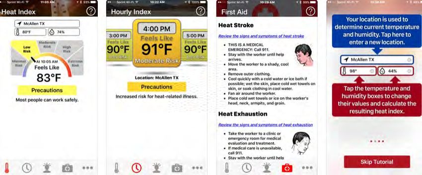
In the U.S., the OSHA and NIOSH developed a Heat Safety Tool (NIOSH, 2018; Figure 1) for iPhone,
iPad, and iPod touch for individual use. The App provides real-time Heat Index information and hourly
forecasts through automatic retrieval from the national meteorological service, anchored by Apple’s
location service, although a manual input option is available, too. The App assesses the heat risk in five
zones: minimal, low, moderate, high and extreme; as well as provides basic knowledge on heat illness
symptoms, linked with first-aid methods for these symptoms. Other pages of the App provide brief
summaries of knowledge on risk factors of heat stress including environment heat stress indicators,
dehydration, physical exertion, PPE, physical condition and health problems, medication, pregnancy, age
and previous heat illness. More tips include acclimatization protocol (7-14 days), training, emergency plan,
hydration protocol, reminder for early signs and rest periods, with a link that informs the users of the
NIOSH guidelines on heat stress management (NIOSH, 2016). The App is being used by project managers
for justifying variations from time used for completing their duties. Feedback from practitioners reflects a
need of geo-coordinated information for people working in remote areas. This is particularly relevant for
megaprojects in Australia, in which the construction project commences from a piece of wild land, without
any landmark or city to reference the location.
1372Andrea Y. Jia
Figure 1. The Heat Safety Tool App (NIOSH 2016)
Figure 2. Online heat stress calculator provided by Work Health and Safety Queensland, Australia
In Australia, Work Health and Safety Queensland (WHSQ, 2017) provides an online Heat Stress
Calculator as a service among the WHS eTools to facilitate businesses’ and organisations’ risk assessment
(Figure 2). The risk assessment results can be printed, saved or converted into pdf file for documentation.
The online calculator can be accessed from PC or any mobile devices. It needs manual input of data, using
Apparent Temperature as an indicator of heat stress. Heat risk is assessed by variables including Air
Temperature, Relative Humidity, type of clothing (not permeable, single layer (light), single layer
(moderate), multiple layers), sun exposure (indoor, full shade, part shade, no shade), hot surfaces (room
temperature, hot on contact, warm on contact, burn on contact), exposure period (less than 30 min, 30-
60 min, 1-2 hours, more than 2 hours), enclosed space (Y/N), task complexity
1373Weather Information Management in Major Construction Projects: State of the Technology.
(simple, moderate, complex), climbing (none, one level, two levels, more than two levels), distance from
cool rest area (< 10 meters, 10-20 meters, 50-100 metres, > 100 metres), understanding heat strain risk
(training given/not), wind speed (strong/moderate/light/none), Respiratory protective equipment (none,
disposable half face, non-disposable half-face, full face), metabolic work rate (light/moderate/heavy),
acclimatization (Y/N). The script of this tool is based on the updated AIOH guidelines by Australian Institute
of Occupational Hygienists (AIOH, 2013: 24-25). Data from users of this tool are stored in a database with
Queensland Government. The issue with this online tool is that no geospatial information is collected with
the risk assessment, which limits the potential of further spatial- temporal analysis of the data that could
inform strategic decisions.
2.3. Georeferencing and BIM-GIS integration
Over its development process, the term BIM is being used to mean building information model, building
information modelling and more recently, building information management (ISO 19650: 2018), indicating
a shift of focus from the product and technology and to the human side of practice. The word ‘building’
has also been extended to roads and infrastructure assets and “the space between constructed elements,
traditionally the domain of landscape architects.” (Plume et al., 2015: 10). Linking BIM with location
information has been a decade-long endeavour (e.g., Young, 2010). BuildingSMART Australiasian worked
with VANZI Ltd to develop a framework for Australia and New Zealand for integrating BIM and GIS for
embedding BIM into its environmental context based on a set of laws, practices and web protocols. This
is developed in conjunction with the Australia’s National Road Map for BIM. The integration of BIM and
GIS will particularly provide geo-referenced models of the built project, which will facilitate emergency
response in disaster situations such as fire, storm, flood and earthquake, etc. (buildingSMART, 2012).
Integrated BIM-GIS models are used at the initiation and planning stage of a project for public
consultation, or the operation stage for facilities management, but its application at construction stage is
limited so far.
Deng et al (2019) developed a protocol to integrate 4D BIM and GIS for supplier selection and supply
chain management, in which a BIM-GIS integrated model served to anchor information of transportation
distance and material unit price. In the delivery of a construction project in The Hague, Ohor et al (2018)
developed a system that allows adding georeferencing information to Revit 2018, which enabled the
designers to relate the design information to the geographical information of the environment and the
site. Ponjavic and Karabegovic (2019) developed a location intelligence system which integrates BIM and
GIS, using WebGIS solution, based on OpenGeo architecture. The system was used for asset management
of an airport, enabling smartphone access to the infrastructure database for inspection. The system is able
to visualize the dynamic information of staff location, aircraft location, wildlife hazard (such as birds)
assessment, and features that inform emergency decisions. They suggest a digital archive system for the
relevant information for maintenance, upgrading and further development of the airport. Such a system
provides a prototype for managing the dynamic process of a major construction project. They suggest to
use the Web Service Bus as part of Enterprise Architecture to facilitate integration.
1374Andrea Y. Jia
3. A participatory approach to weather information management
3.1. Participatory data collection
The participatory approach is often used in urban planning where citizens have an immediate stake in its
decisions (e.g., Kahila-Tani et al., 2015; Dionisio et al., 2016). Geospatial tools are being used for
stakeholder and community engagement in urban planning, such as Envision and ESP (Envision Scenario
Planner) (AURIN, 2019), although concerned were raised that the development of GIS or equivalent
technologies brought damage to vulnerable, poor and marginalized social groups (Kyem, 2000). However,
the actual process of public engagement happens in a way that planners draw from their professional
expertise to make decisions; the community participation process is used more for persuasion of the
community or selecting among a few options rather than for real elicitation of information. There is not
yet a clear plan how the data will inform the planning decision. In the same rationale, the great potential
of data from the daily practice of frontline workers on construction site is not being elicited to inform
project planning. This hidden power can be released if better connection is planned, if the data is planned
and properly structured and connected to the project planning stage.
Matthews et al (2015) present a case of the RC frame (formwork, reinforcement and concrete) in a
commercial office development project in Perth’s New City Link project using cloud-based BIM to manage
the progress of the RC structure construction process. They re-engineered the project’s paper- based
process to align it with the information structure needed by the cloud-based BIM, and designed a real-
time object oriented bi-directional system to capture information on site and synchronize it with a
federated BIM model. The adoption of this technological innovation resulted in a process innovation in
terms of workflow and progress management. The modelling process acted as a system integrator during
which the tasks are aligned with the schedule, the Quality Assurance procedures with the completed tasks
reporting, which made the data searchable. The site engineers and foremen were engaged to monitor the
real time progress with an iPad and report the data to the project planner, through the cloud-based BIM,
for regular project schedule update.
3.2 Agent-based modelling
Agent-based modelling is another technology that frees up BIM from making more and more complicated
models to accommodate emergent situations by developing agents of specific behavioural characteristics
(Couch, 2016). It is primarily used in Smart Cities modelling for simulating human social behaviours and
interactions (Perez et al., 2017), and has the potential to be used for modelling the dynamic environment
on construction site. Hattab and Hamzeh (2018) combine agent-based modelling with social network
analysis to examine how the adoption of BIM has changed the design workflow. Trivedi and Rao (2018)
use agent-based modelling to analyse alternative scenarios of human panic behaviours for evaluation of
emergency evacuation strategies and identification of possible bottlenecks and deficiencies, indicated by
evacuation time and physical discomfort that caused to agents.
3.3. Envisioning a bottom-up approach
A three-tier safety risk assessment procedure, as observed by the author in 2017 in a megaproject in
Australia, includes Safe Work Method Statement (SWMS) every three months, Job Hazard Analysis (JHA)
on starting every new task, and personal risk assessment (PRA). SWMS and JHA were conducted by safety
advisors or supervisors. The PRA is conducted by every single workers three times a day.
1375Weather Information Management in Major Construction Projects: State of the Technology.
However, in the established practice on site, the many PRAs completed daily were not followed by
immediate mitigation of the risks but were used for documentation only. Such outcome suggests that the
PRA is particularly of potential to be mobilized for personalised risk control and automated data collection,
which will enable the generation of smart (real-time and interactive) and personal alert and risk
management advice.
BIM model carried in mobile device opens the possibility for workers’ participation in design and data
collection. Data need to be centralized to inform strategic decisions, and to be localized for effective risk
mitigation (Lundgren-Kownacki et al., 2017a). Thus a dule-level weather information management system
is suggested for major projects: engage and empower local actors for personal risk mitigation; tighten
inter-project coupling to pool the data for future weather-wise project planning. At individual level, what
needs to be done is to close the loop of a personal risk management system such that individual workers
can assess and mitigate their own heat stress at their specific workplace. A mobile App is needed to input
and analyse the parameters of the specific work space as well as the workers’ health information. These
data should be available to the individual worker only to ensure privacy while providing the specific user
personalized information for a heat risk assessment at a specific workplace. The anonymised data should
then be pooled for future estimation and project planning. This has to be realised through inter-project
learning.
Database for
General
future information
estimation
Inter-project
learning
Personal heat
worker
risk assessment
immediate mitigation
Georeferencing
Personal health information
Figure 3. The envisioned two-tier heat stress risk management system
1376Andrea Y. Jia
4. Conclusion
This paper presents a brief review of the state of the technology for weather information management in
major construction projects. There is a need to engage workers to participate in and contribute to the
whole weather information management process. The information exclusively owned by individual
workers is their own personal health information and their local knowledge of the spatial environmental
characteristics of the workplace and the task, which is of value to inter-project level and industry level
planning. A participatory georeferenced BIM system is needed to mitigate the heat stress risk locally while
collecting anonymised data on the complex conditions of construction sites for future project planning. A
central database is needed at inter-project level to store and corroborate such information, which should
be submitted to a national database for future estimation of project cost and duration in tendering. The
challenge with system design is how to register the complex spatial characteristics in the workplaces on
construction site; how to put feasible and low-cost sensors to capture and transmit the needed data,
including radiant heat and air velocity. This study contributes to a solution-oriented bottom-up approach
to weather information management in major construction projects.
Acknowledgement
The author would like to acknowledge the support of Melbourne School of Design at University of
Melbourne where she worked as a Senior Lecturer in Construction Management during the writing of this
paper.
References
AIOH 2013. A Guide for Managing Heat Stress, Tullamarine, The Australian Institute of Occupational
Hygienists.
Assaf, S. A. & Al-Hejji, S. 2006. Causes of delay in construction projects. International Journal of Project
Management, 24(4), 349-357.
URIN 2019. Envision Scenario Planning Tool (ESP), Australian Urban Research Infrastructure Network
(AURIN) and The University of Melbourne, https://aurin.org.au/resources/decision-support/esp.
Ballesteros-Pérez, P., Rojas-Céspedes, Y. A., Hughes, W., Kabiri, S., Pellicer, E., Mora-Melià, D. & Campo-
Hitschfeld, M. L. d. 2017. Weather-wise: A weather-aware planning tool for improving construction
productivity and dealing with claims. Automation in Construction, 84, 81-95.
Ballesteros-Pérez, P., Smith, S. T., Lloyd-Papworth, J. G. & Cooke, P. 2018. Incorporating the effect of
weather in construction scheduling and management with sine wave curves: application in the United
Kingdom. Construction Management and Economics, 36(12), 666-682.
Deng, Y., Gan, V. J. L., Das, M., Cheng, J. C. P. & Anumba, C. 2019. Integrating 4D BIM and GIS for
construction supply chain management. Journal of Construction Engineering and Management, 145(4)
https://doi.org/10.1061/(ASCE)CO.1943-7862.0001633.
Dionisio, M. R., Kingham, S., Banwell, K. & Neveille, J. 2016. Geospatial tools for community engagement
in the Christchurch rebuild, New Zealand. Sustainable Cities and Society, 27, 233-243.
ISO 19650-1 2018. Organization and digitization of information about buildings and civil engineering
works, including building information modelling (BIM) - Information management using building
information modelling - Part 1: Concepts and principles, Geneva, International Organization for
Standardization.
1377Weather Information Management in Major Construction Projects: State of the Technology.
ISO 19650-2 2018. Organization and digitization of information about buildings and civil engineering
works, including building information modelling (BIM) - Information management using building
information modelling - Part 2: Delivery phase of the assets, Geneva, International Organization for
Standardization.
Jia A.Y., Loosemore M., Gilbert D. & Rowlinson S. 2016a. Shielding workers from heat stress: an
institutional logics perspective, In P W Chan (Eds.), Proceedings of 32nd Annual ARCOM Conference,
Manchester, UK: Association of Researchers in Construction Management.
Jia A. Y., Rowlinson S. & Ciccarelli M. 2016b. Climatic and psychosocial risk factors of heat illness cases on
construction site, Applied Ergonomics, 53, 25-35.
Jia A.Y., Gilbert D. & Rowlinson S. 2018. Seasonal patterns of thermal stress in the work environment of
construction site in a megaproject in Australia. In Proceedings of the 52nd International Conference of
the Architectural Science Association (ANZAScA), Melbourne.
Jia A.Y., Rowlinson S., Loosemore M., Gilbert D. & Ciccarelli M. 2019. Institutional logics of processing
safety in production: The case of heat stress management in a megaproject in Australia, Safety Science,
120, 388-401.
Jia A. Y., Gilbert D., Tymvios N., Goh Y.M., Behm M. & Rowlinson S., 2020. Tuning into heat: acclimatization
on construction site and horizontal integration in major project management, In Proceedings of the
CIB W099/TG59 Annual Conference, Glasgow, UK.
Jung, M., Park, M., Lee, H.-S. & Kim, H. 2016. Weather-delay simulation model based on vertical weather
profile for high-rise building construction. Journal of Construction Engineering and Management,
142(6), 4016007.
Kahila-Tani, M., Broberg, A., Kyttä, M. & Tyger, T. 2015. Let the citizens map - public participation GIS as a
planning support system in the Helsinki master plan process. Planning Practice & Research, Dec 2015,
1-20.
Kyem, P. A. K. 2000. Embedding GIS Applications into Resource Management and Planning Activities of
Local and Indigenous Communities A Desirable Innovation or a Destabilizing Enterprise? Journal of
Planning Education and Research, 20, 176-186.
Loosemore, M. and Andonakis, N., 2007. Barriers to implementing OHS reforms – the experiences of small
subcontractors in the Australian construction industry, International Journal of Project Management,
25(6), 579-588.
Lundgren-Kownacki, K., Kjellberg, S. M., Gooch, P., Dabaieh, M., Anandh, L. & Venugopal, V. 2017a.
Climate change-induced heat risks for migrant populations working at brick kilns in India: a
transdisciplinary approach. International Journal of Biometeorology, 62(3), 347-358.
Matthews, J., Love, P. E. D., Heinemann, S., Chandler, R., Rumsey, C. & Olatunj, O. 2015. Real time progress
management: Re-engineering processes for cloud-based BIM in construction. Automation in
Construction, 58(October 2015), 38-47.
NIOSH 2018. OSHA-NIOSH Heat Safety Tool App, US, National Institute of Occupational Safety and Health,
https://www.osha.gov/SLTC/heatillness/heat_index/heat_app.html.
Nguyen, L. D., Kneppers, J., de Soto, B. G. & Ibbs, W. 2010. Analysis of adverse weather for excusable
delays. Journal of Construction Engineering and Management, 136(12), 1258 – 1267.
Ohor, K. A., Diakité, A., Krijnen, T., Ledoux, H. & Stoter, J. 2018. Processing BIM and GIS Models in Practice:
Experiences and Recommendations from a GeoBIM Project in The Netherlands. ISPRS International
Journal of Geo-Information, 7(8) 10.3390/ijgi7080311.
1378Andrea Y. Jia
Perez, P., Banos, A. & Pettit, C. 2017. Agent-based modelling for urban planning: current limitations and
future trends. In: Namazi-Rad, M.-R., Padgham, L., Perez, P., Nagel, K. & Bazzan, A. (eds.) Agent Based
Modelling of Urban Systems. Berlin: Springer.
Plume, J., Simpson, R. & Hobson, A. 2015. Integration of Geospatial and Built Environment - National Data
Policy, buildingSMART Australia and SIBA.
Ponjavic, M. & Karabegovic, A. 2019. Location Intelligence Systems and Data Integration for Airport
Capacities Planning. Computers, 8(13) DOI: 10.3390/computers8010013.
Rajagopalan, P., Santamouris, M. & Andamon, M. M. 2017. Public engagement in urban microclimate
research: an overview of a citizen science project. In: Schnabel, M. A. (ed.) Back to the Future: The Next
50 Years, 51st International Conference of the Architectural Science Association (ANZAScA).
Wellington: The Architectural Science Association and Victoria University of Wellington
Spirig, C., Noti, P., Messeri, A., Morabito, M., Kotlarski, S., Casanueva, A. & Liniger, M. 2017. Prototype of
a local/regional warning system predicting environmental heat strain based on an ensemble forecast
model for the upcoming weeks, RUL: www.heat-shield.edu (accessed on 18 April 2019).
Thorpe, D. & Karan, E. P. 2008. Method for calculating schedule delay considering weather conditions. In:
Dainty, A. (ed.) Procs 24th Annual ARCOM Conference, 1-3 September 2008. Cardiff, UK: Association
of Researchers in Construction Management.
Tian, W. & de Wilde, P. 2011. Uncertainty and sensitivity analysis of building performance using
probabilistic climate projections: a UK case study. Automation in Construction, 20, 1096-1109.
Trivedi, A. & Rao, S. 2018. Agent-based modeling of emergency evacuations considering human panic
behavior. IEEE Transactions on Computational Social Systems, 5(1), 277-289.
WHSQ 2017. Heat Stress (Basic) Calculator, Queensland Government, Australia, Work Health and Safety
Queensland, Office of Industrial Relations, URL: https://fswqap.worksafe.qld.gov.au/etools.
1379You can also read