Extracting user habits from Google maps history logs - MASTER
←
→
Page content transcription
If your browser does not render page correctly, please read the page content below
2018 IEEE/ACM International Conference on Advances in Social Networks Analysis and Mining (ASONAM)

                            Extracting user habits from Google maps history logs

              Christos Sardianos                                Iraklis Varlamis                               Grigoris Bouras
     Dept. of Informatics and Telematics              Dept. of Informatics and Telematics            Dept. of Informatics and Telematics
      Harokopio University of Athens                   Harokopio University of Athens                 Harokopio University of Athens
                Athens, Greece                                   Athens, Greece                                 Athens, Greece
          Email: sardianos@hua.gr                          Email: varlamis@hua.gr                          Email: it21239@hua.gr

   Abstract—The exponential growth in the usage of smart                       from other users’ location sharing, we can assume that this
devices, such as smartphones, interconnected wearables etc.,                   type of user network can be consider a social network with
creates a huge amount of information to manage and many                        location-based information. This assumption led to the rise
research and business opportunities. Such smart devices be-
come a useful tool for user movement recognition, since they                   of Location-Based Social networks [2].
are equipped with different types of sensors and processors                       The information about the places that a user has visited
that can process sensor data and extract useful knowledge.                     can be exploited in many ways, for example, for promot-
Taking advantage of the GPS sensor, they can collect the                       ing POIs that match user’s profile [3], for recommending
timestamped geographical coordinates of the user, which can                    alternatives to his/her fellow users and friends in a location-
then be used to extract the geographical location and movement
of the user. Our work, takes this analysis one step ahead and                  based social network [4], for extracting useful statistics
attempts to identify the user’s behavior and habits, based on                  about the popularity of POIs, etc. A recommender system
the analysis of user’s location data. This type of information                 can take advantage of user location history only, can add
can be valuable for many other domains such as Recommender                     content information from social networks, from explicit
Systems, targeted/personalized advertising etc. In this paper, we              and implicit user preferences, from third-part services that
present a methodology for analyzing user location information
in order to identify user habits. To achieve this, we analyze                  provide information about POIs (e.g. Yelp, Foursquare, Open
user’s GPS logs provided through his Google location history,                  Street Maps etc.), or even can take advantage of the temporal
we find locations that user usually spends more time, and after                information behind each check-in [5].
identifying the user’s frequently preferred transportation types                  In this work, we consider two different types of informa-
and trajectories, we find what type of places the user visits in               tion that can be extracted from user GPS data: i) location
a regular base (such as cinemas, restaurants, gyms, bars etc)
and extract the habits that the user is most likely to have.
                                                                               information, for places that the user has visited, along
                                                                               with the timestamp and duration of the visit, ii) trajectory
   Keywords-habit recognition, trajectory patterns, significant                information, concerning the movement of a user from one
places.
                                                                               location to another.
                                                                                  We process user GPS logs and extract this information
                         I. I NTRODUCTION                                      at the first step and then enrich and abstract this informa-
   Nowadays, mobile devices and smartphones have earned                        tion in order to extract interesting user behavioral patterns,
an essential role in our society, penetrating many facets                      comprising:
of everyday life. This is obvious if we consider that 80%                         • frequently visited POIs and POI types,
of the Internet users own a smartphone [1], while mobile                          • frequent trajectories and preferred transition type,
application usage is growing by 6% every year. Modern                             • temporal patterns that associate user preference with
smart devices are equipped with multiple ambient sensors                             the day of the week or the timezone of each activity.
that provide great amounts of data, which can be analyzed                         In section II that follows, we summarize the most impor-
to discover useful information such as daily user patterns,                    tant works that relate to the extraction of user habits from
trajectory patterns etc. According to an MIT Technology                        user location data and take advantage of this information
Review1 , the collection and analysis of information from                      for generating personalized recommendations. In section III
simple cellphones can provide surprising insights into how                     we provide an overview of the proposed method and in
people move about and behave. Moreover, if we consider                         section IV we provide the implementation details of each
that users are sharing location information with other users,                  processing step. Finally, section V provides a demonstration
providing real-time updates to other users and benefiting                      of the proposed method on data obtained from Google Maps
                                                                               history of a user and section VI summarizes our progress
  1 http://www.technologyreview.com/featuredstory/513721/big-data-from-
                                                                               so far and the next steps of this work that are expected
cheap-phones                                                                   to lead to a recommender system that delivers the right
                                                                               recommendation at the right moment.
IEEE/ACM ASONAM 2018, August 28-31, 2018, Barcelona, Spain 978-1-5386-6051-5/18/$31.00 © 2018 IEEE
978-1-5386-6051-5/18/$31.00 © 2018 IEEE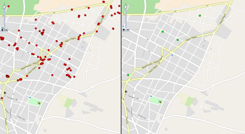
II. R ELATED W ORK in the form of temporal patterns that repeatedly occur in user
logs and refer to the same locations or location types and
The concept of mining useful knowledge from GPS logs the same movement type across repeated trajectories.
has been discussed several times in the related literature.
The survey work of Zheng [6] in trajectory data mining, III. P ROBLEM DEFINITION - M ETHOD OVERVIEW
summarizes all paradigms of trajectory mining and the issues The proposed method for extracting user habits from user
that must be considered. More specifically, when it comes GPS logs, follows a step-wise approach, which begins with
to user trajectories, early works [7] analyze GPS logs in solving simple problems, such as the detection of user stay
order to mine interesting locations and travel sequences, points and user trajectories between consecutive stay points,
employ user location history to measure user similarity [8], continues with the semantic annotation and enrichment of
or identify and assign significance to semantic locations the extracted stay points and trajectories and ends with the
based on GPS records [9], whereas more recent works [10] abstraction of these movements to user movement patters
take advantage of user location history and a richer content that are repeated periodically with increased frequency.
(i.e. user sentiment, user interest and location properties) in In the following subsections, we explain the steps of the
order to better match users to locations and recommend POIs proposed method.
of interest to users. Collaborative applications have boosted
A. Extraction of stay points and user trajectories
the interest of GPS log mining and introduced location
and activity recommender systems and location-based social A stay point SP stands for a geographic region, where
networks. The survey work of Bao et al [11] provides a a user stays over a certain time interval [7]. The extraction
taxonomy of recommender systems that build around social of a stay point depends on two parameters, a time interval
and location based information for supporting Location- threshold (Tthreh ) and a distance threshold (Dthreh ). For
Based social networks. Such applications, are based on example, for the set of GPS points depicted in Figure 1,
user location and trajectory data [12]–[14], the overall user that correspond to the consecutive positions of a moving
behavior and social circle in order to recommend POIs [15] user, the stay point SP can be regarded as the virtual
or trajectories [16] that connect places of interest. location containing a subset of consecutive GPS points
Despite the long interest on user location and trajectory SP = {pm , pm+1 , ..., pn }, where 8i, j 2 [m, n] it holds
history, there have only been a few works that take advan- that Distance(pi , pj ) Dthreh and |pi .T pj .T | Tthreh ,
tage of user’s latent behavior patterns in order to provide where pi .T is the timestamp associated with point pi . The
personalized recommendations. It is worth to mention the centroid of all GPS points that grouped under the same stay
work of He et al [15], who attempt to jointly model next point location, is used as the GPS coordinates of stay point
POI recommendation under the influence of user’s latent SP and a maximum radius for the cluster is also kept with
behavior pattern. Authors adopt a third-rank tensor to model the stay point. Finally, since the stay point represents the
the successive check-in behaviors of a user in POIs and fuse stay of the user in a location for a time period, we keep the
it to the personalized Markov chain of observed successive start and end time-stamp with the stay point. So, a stay point
user check-ins, in order to improve POI recommendations. is characterized as: SP =< lat, lon, radius, tstart , tend >.
They generalize user check-in history at day of week level
in the time dimension and at POI category in the POI
dimension. However, in their model they limit user profiling
only on the POIs and not on the trajectories between POIs.
In a slightly different context, authors in [5] introduce the
concept of temporal matching between user profile and POI
popularity. They profile the temporal pattern of area activity
around POIs, using information from taxi pick-ups and drop-
offs and propose that every user has a latent daily-repeated
personalized temporal regularity, which decides when he/she
is likely to explore POIs every day.
The method that we propose in this paper, is based on the
analysis of user GPS data in order to extract useful informa- Figure 1. Stay point example.
tion concerning the user’s behavior and habits. It combines
methods and techniques from the related literature and Consequently, a user trajectory T rij is defined as the
proposes an implementation for extracting spatio-temporal sequence of GPS points between two stay points SPi and
user patterns, which can then be used as a basis for temporal SPj . T rij defines a route comprising a series of GPS loca-
and interest-aware activity recommender systems. However, tions in chronological order. Stay points denote the end of
it differs from existing systems in that it extracts user habits one trajectory and the beginning of another. The timestamp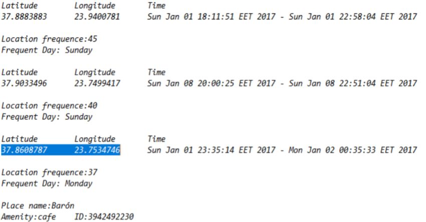
difference between two consecutive points (GPS locations’          the trajectory points information (latitude, longitude and
timestamps) in a trajectory, is exceeded, so that they cannot      timestamp) and the detection of user type of movement
be considered to belong in the same stay point. Figure 2           across the trajectory. This allows to detect at a later stage,
presents an example of a user trajectory connecting two            the preferred way of movement for specific trajectories or
consecutive stay points. So a user trajectory is characterized     overall, whether the user uses public or private means of
by a set of GPS coordinates a start and an end time-stamp          transportation etc. We treat the problem of detection of
as: T r=< {(lati , loni )}, trstart , trend >.                     user movement type across a trajectory as classification
                                                                   problem [17], [18], and build on our previous work on
                                                                   the topic [19], [20]. The movement categories can be:
                                                                   motionless, walking, running, riding a bike, driving a car,
                                                                   being on the bus, being on a train/metro, and any other
                                                                   type of movement. At the end of this step a trajectory is
                                                                   characterized as:
                                                                   T r =< {(lati , loni )}, movtype , P OIstart , P OIend , tstart , tend >

                                                                   C. Abstracting user data to user habits
                  Figure 2.   Trajectory example.                     By the term user habits we describe a routine of behavior
                                                                   that the user repeats regularly and which tends to occur
                                                                   subconsciously [21], [22]. To adopt this to the scenario of
B. Semantic enhancement of stay points and user trajecto-          user trajectory data, habits are repetitive user activities such
ries                                                               as: being in the same stay point at the same time or day of
   When a stay point or a trajectory is extracted, the             a week, taking the same trajectory at the same time or week
proposed method applies a semantic enrichment process,             day.
which attaches additional information that can be useful for          The analysis of user trajectories at user group level, will
extracting user habits at a later stage. The information for       allow to detect how often places are visited and understand
characterizing stay points can be provided from different          which locations are the most popular on week days or
sources. However, the main sources are POI information             weekends, in the morning or afternoon and which locations
services, which provide semantic annotations for popular           are visited for a few moments or for longer periods [23].
points of interest as well as for common types of POIs (e.g.       When examined at user level, the trajectories can define a
leisure places, sport facilities, public buildings, transporta-    set of user behaviors, highlight user habits and allow recom-
tion hubs etc). Although POI information services cover            mender algorithms or similar applications to provide user-
a large amount of locations, there are still stay points           tailored location and time based recommendations. Finally,
that can not be characterized without the user’s interven-         in a collaborative environment (e.g. in location based social
tion. Following the practice of popular on-the-go driving
directions applications (e.g. Google Maps), users can add
more personal semantic information for their own points
of interest such as "Home" or "Work". These explicitly
provided annotations usually refer to frequently accessed
stay points that cannot be easily mapped to a known POI.
As described in Section III, a stay point SP is defined as
any geographic region where the user stayed for at least
a short time of period (e.g. a store or an office) or even a
location where the user slightly moved around, but not away
from it (e.g. a park or a stadium etc.). So after extracting the
possible stay points of the user, we access POI information
services and search for nearby POIs, at a short range and
always within the stay point limits. Using the same services,
we are able to characterize the stay point by the type, such
as: Park, Stadium, Leisure ground, Athletic center, Beach,
Shopping center, Cafeteria etc. At the end of this step a stay
point is characterized as:
SP =< lat, lon, P OItype , P OIcategory , tstart , tend >
   The semantic annotation of user trajectories, mainly
refers to the application of data mining techniques to                         Figure 3.   Basic architecture of the application.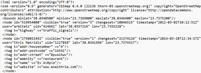
networks) users can be compared based on their detected           a moving speed threshold, we can compute an acceptable
habits and collaborative filtering can be fused with user         value for M inP ts. The parameterization of the algorithm
location and time context (and habits) information.               has been described in [20].
   The extraction of user habits begins with the detection of        A spatial clustering of user location data, using a density-
frequent occurring patterns in user GPS logs (e.g. frequently     based clustering algorithm, is expected to identify areas
accessed POIs and trajectories) and continues with the            with very dense recorded spots and areas where the user
abstraction of information at various levels of granularity in    passed through at a quick pace. This clustering will provide
time (e.g. time zones, days, etc), POI type, and movement         information for places that user spends time during the
type. The result of this process comprises frequently occur-      day, even when the user is standing or walking around
ring staying or movement patterns for one or more users.          (in a park) or running (in a stadium). The use of time
Defining our approach for analysis, we can describe it as         distance in the distance measure of DBSCAN will change
a three-tier analysis with multiple tasks in each tier. In the    the resulting clusters, and will allow to distinguish between a
sections that follow we will describe our methodology in          stay point and a point that the user crosses several times but
more detail. Figure 3 describes the basic architecture of our     in different (distant) timestamps. A time-ignorant DBSCAN
application.                                                      will detect a single cluster for all points, whereas a time-
                                                                  aware version will detect separate clusters. An incremental
              IV. S YSTEM IMPLEMENTATION                          version of DBSCAN, allows to cluster the most recent GPS
A. Data collection                                                traces of a user and detect the stay points as they occur, and
   The first step of the proposed method is the collection of     consequently assign all intermediate points to the trajectory.
user GPS data. Although in previous works we employed             The steps of the stay point extraction process are depicted
actual GPS data collected by the user smart-phone, in this        in Figure 4.
work we use data from Google Maps history, which are
imported as KML (Keyhole Markup Language) files to the
system. KML is a file format based on the XML standard
and uses a tag-based structure with nested elements and
attributes to express geographic data (such as locations,
image overlays, video links and modeling information like
lines, shapes, 3D images and points) in location browsers
such as Google Earth and Google Maps.
   The same processing pipeline can be applied to the actual            Figure 4.   Workflow for identifying frequent user locations.
GPS data collected by the smart-phone instead of using the
KML file. The information extracted from the analysis of             Figure 5 depicts the results of the stay point extraction
a user activity in a certain time-frame can be stored in the      process on a map. On the left part all the GPS points, before
phone and all the actual GPS data for this frame can be           the detection of stay points are shown on the map in red,
erased. For example, when the user commutes to work, we           whereas on the right part the detected stay points only are
can store information about the trajectory (e.g. start/end time   marked with green color.
and location, and probably a few intermediate points) and
erase all the intermediate GPS data.
B. Information extraction
   1) Extraction of user stay points: The initial task on the
analysis of user location data is to identify the locations,
where the user stays for a certain amount of time. For
this purpose, following the visit point extraction method
described in [24], we employ DBSCAN [25], a density-
based clustering algorithm, which finds clusters of dense
points using a range threshold eps and a minimum number
of points M inP ts within this range as parameters. We im-
plement a spatio-temporal version of DBSCAN (the distance
of two points is a linear combination of geographic distance      Figure 5. All GPS points of user (on the left) and the results of detected
and time distance), which clusters together neighboring (in       stay points (on the right).
space and time) GPS traces and ignores all other points
(considers them noise). Depending on the frequency of                2) Detection of user trajectories: The detection of user
recorded GPS spots, the distance threshold of interest and        trajectories is binded to the detection of stay points and
trajectories are directly defined as the sets of GPS tracks on a known PT route. Building on our previous work on
between two consecutive stay points. Considering the fact the topic [19], [20] we classify each trace individually and
that a large set of stay points may exist in user’s GPS logs, then classify the trajectory as a whole. If there exists a set
a respectively large set of trajectories are formed among of pre-classified movement samples we train a personalized
the different stay points. So the result of this information model for each user, else a pre-trained generic model is used,
extraction step comprises two sets: a set of user’s stay points which uses a set of direct (latitude, longitude, timestamp)
and a set of trajectories that join consecutive stay points. and indirect features (speed, speed changes, distance from
transportation related POIs such as bus stops or metro
C. Information enhancement stations) in order to characterize how the user moved across
1) Semantic characterization of stay points: After user’s a trajectory [20]. Since our original classifier is incremental
stay points and trajectories are detected, they are annotated and annotates the last trajectory part with the detected
with additional information, which is collected by third party movement type it is frequent that for a long trajectory, more
services or extracted by data mining algorithms, and which than one movement types have occurred (e.g. the user drives
can be used in the user habits extraction step. The charac- but stops at the traffic lights or is stuck behind a bus for part
terization of stay points step employs the OpenStreetMaps of the trajectory). When the next stay point is detected and
service, which offers an API for retrieving information about the trajectory is completed, a post-processing step aggregates
various POIs in a geographical area. For this purpose, a this information for all segments of the trajectory and assigns
bounding box is created for each stay point, using the the movement type that most likely matches to the specific
GPS coordinates of the stay point as the bounding box trajectory.
center and a range that does not exceed the radius of the To provide an example, let’s assume the daily commute of
respective cluster. The OpenStreetMaps API is accessed to a user to work as depicted in Figure 7. The user drives from
retrieve POIs within the geographical area defined by the home to the nearest train station, parks the car and takes the
bounding box and it responds with an XML formated result, train from station A to the nearest station (station B) at work,
as depicted in Figure 6. then walks to commute to work. The stay point detection
algorithm will detect four stay points (home, parking lot of
train station A, train station B, work) and three trajectories
that connect them. The first trajectory will be annotated as
driving, the second as moving by metro/train and the last as
walking. The sub-trajectory from the train station’s parking
lot to the station building will not be detected if the two
places are close to each other. The walk of the user from
the parking lot to the train station will also be considered as
part of user’s visit to the specific stay point (i.e. train station
A).
Figure 6. Sample of the XML response with tags for stay points.
The file contains all possible Points-of-Interest marked
with tags that characterize the type of POIs inside the
bounding box of the stay point, such as:
• amenity
• public transport
Figure 7. An example of a user commuting to work. The detection and
• shop annotation of stay points and trajectories.
• sport
• leisure
From the locations returned by the POI service, the closest D. Information abstraction
to the stay point is used to characterize the stay point. The 1) Detection of frequent user stay points: The next phase
result of this process is that the user stayed at a specific POI of the process is to extract the frequent stay points and
(which is of certain type and category) for a specific time trajectories of a user based on his/her location history. By
period. analyzing the stay points of a user for a long time period,
2) Detecting type of movement in a trajectory: For the we can find if the user tends to visit specific stay points
semantic annotation of a user trajectory, we process all more frequently. To achieve this, we cluster stay points using
consecutive GPS traces in order to detect user movement a distance-based only DBSCAN and result with clusters
speed, user direction and user speed changes, we also check containing points that have been visited many times by
if the traces are near a public transportation (PT) stop or the user. We rank clusters in descending order of size andkeep the top ranked stay points for a user. Along with the (e.g. home ! work ! gym ! restaurant ! home) at specific
GPS coordinates of each stay point, we have time-stamp dates and times.
information concerning the start and end time of the user’s The process of user habits extraction, can be treated as an
stay. A first step of information abstraction is to find the association rules extraction problem. Before extracting fre-
preferred days or time zones for a user to visit a stay point. quent patters and interesting rules, it is important to process
The result of this step can be similar to the following: The the annotated stay point and trajectory information and get
user has visited train station A n times this month. The different levels of abstraction. For example, different places
preferred days are week days, and the preferred time zones that have been visited by the user and have been annotated
are early in the morning and the afternoon. as restaurants, bars or cafeterias can be generalized to the
2) Detection of frequent trajectories: Similar to the anal- category amenity and lead to rules with stronger support, the
ysis of stay points, the analysis of user trajectories will time-stamp information can be mapped to day zones (e.g.
highlight the preferred movement paths of the user and the morning, afternoon, evening) or days, using different levels
preferred way of movement. We focus only on the frequent of granularity. The output of this information abstraction step
stay points for a user and considering the set of trajectories is fed to the association rule extraction algorithm, which in
that the user has followed to go from one stay point to our case is the Apriori algorithm [27].
another. We apply the clustering-based sequential mining
(CBM) algorithm [26] over the set of trajectories and the V. R EAL CASE DEMONSTRATION
output of this process is the set of most frequent trajectories In order to demonstrate our proposed method for extract-
followed by the user. In detail, the CBM algorithm is based ing user habits from user trajectory data, we developed an
on the clustering of the set of points that belong to the application that takes Google Maps History files (KML files)
trajectory, so in our case the input of the algorithm is the as input and processes them following the process described
set of user trajectories that connect user frequently accessed in the previous sections. The application is written in Java
stay points and two parameters, namely s and x. Parameter s and is available as a standalone Java program (Figure 9).
defines the square area occupied by each cluster on the map
and parameter x defines the minimum number of points that
a cluster has to contain in order to be considered as active
(that means that is frequently part of the user’s trajectories).
The frequent trajectories are characterized by the start and
end location and the set of start (departure) and end (arrival)
time-stamps and type of movement for each trajectory
instance, as follows:
F reqT r =< P OIstart , P OIend , {(movtype , tstart , tend )i } >
The processing pipeline is summarized in Figure 8.
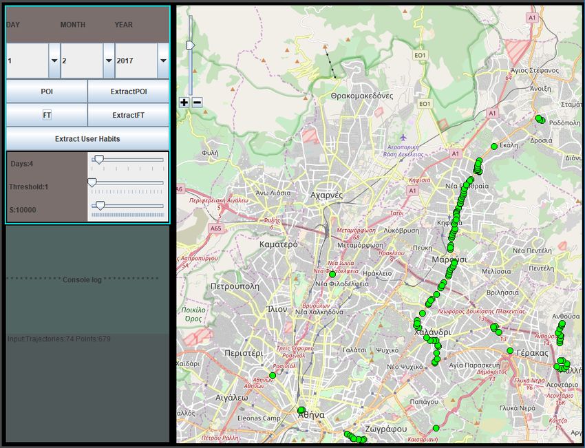
Figure 9. Snapshot of the application.
Through the application the user has a set of options that
can trigger the analysis of the location data contained in
Figure 8. Frequent trajectories extraction pipeline.
the KML file, which may span several days or months.
The user can either analyze the loaded data and depict
them over an OpenStreetMap map embedded in the user
interface, or extract the results of the information extraction
E. Extracting user habits
and enhancement step to output files for further analysis.
The last processing step aims to use the information ex- Using these files as input, we can extract the user’s frequent
tracted from the previous steps and find frequently occurring stay points and trajectories, which can be displayed over an
activity patterns in user logs, which will define the user’s OpenStreetMap layer or exported to separate files.
habits. The analysis of information concerning frequently The analysis of user stay points leads to a set of user’s
visited locations, which the user visits periodically, and tendencies like the ones displayed in Figure 10.
frequent trajectories that the user follows to reach these These files are then fed to the Apriori algorithm to extract
destinations, will discover user’s tendencies on commuting user habits. The input data that we use consist of thepatterns for the user daily activity. This type of information
could be exploited furthermore in many types of applications
and fields of research, such as recommender systems for
providing personalized recommendations.
Having that said, we consider this is a field of interest
with lots of potential and it is in our intention to adapt our
work so far in order to lead us to a recommender system
that would deliver real-time and real-life recommendations
based on user habits.
Moreover, the parameter selection of the algorithms has
been made after experimentation on the specific dataset. A
Figure 10. An example user habit based on frequent stay points: User
more thorough evaluation of different parameter settings is
visits the “Baron cafe” on Sunday and Monday evenings. part of our next work on the field.
ACKNOWLEDGEMENTS
user’s extracted stay points combined with the time-stamp This work has been developed in the frame of the MAS-
of occurrence after converting the actual start and end time- TER project, which has received funding from the European
stamps into daytime zone (e.g. morning, afternoon, night) Union's Horizon 2020 research and innovation programme
and day (e.g. weekday, weekend), the type of movement under the Marie Skłodowska-Curie grant agreement No
at that moment and/or the type of the amenity. The set 777695.
of categorical features are fed into the Apriori association This paper was made possible by National Priorities
rules algorithm. So, when the Apriori algorithm is fed with Research Program (NPRP) grant No. 10-0130-170288 from
information in the form of: the Qatar National Research Fund (a member of Qatar
{DayZone, DayT ype, M oveT ype, Dest_P OIT ype }, Foundation). The statements made herein are solely the
where DayT ype can be weekday or weekend and the responsibility of the authors.
Dest_P OICategory can be the type of POI detected as
frequent stay point (e.g. cafeteria), the extracted user habits R EFERENCES
are similar to those depicted in Figure 11. [1] D. Bosomworth, “Mobile marketing statistics 2015,” Leeds:
Smart Insights (Marketing Intelligence) Ltd, 2015.
[2] P. Symeonidis, D. Ntempos, and Y. Manolopoulos, “Location-
based social networks,” in Recommender systems for location-
based social networks. Springer, 2014, pp. 35–48.
[3] W.-Y. Zhu, W.-C. Peng, L.-J. Chen, K. Zheng, and X. Zhou,
Figure 11. Sample of the extracted habits after the Apriori execution. “Modeling user mobility for location promotion in location-
based social networks,” in Proceedings of the 21th ACM
SIGKDD International Conference on Knowledge Discovery
Based on the sample result of Figure 11 we can assume and Data Mining. ACM, 2015, pp. 1573–1582.
for example, based on rules No. 2, 3 and 4 that the user tends
to commute by metro in the workday evenings, while based [4] Y. Yu and X. Chen, “A survey of point-of-interest recommen-
on rule No. 5 user also tends to visit a shop on working dation in location-based social networks,” in Workshops at the
days. Twenty-Ninth AAAI Conference on Artificial Intelligence, vol.
130, 2015.
VI. C ONCLUSIONS AND NEXT STEPS
[5] Q. Yuan, G. Cong, Z. Ma, A. Sun, and N. M. Thalmann,
Considering the implicit interaction among users who are “Time-aware point-of-interest recommendation,” in Proceed-
sharing location information with other users, we can assume ings of the 36th international ACM SIGIR conference on
Research and development in information retrieval. ACM,
that these users form a type of social network with location-
2013, pp. 363–372.
based information. In this work, we presented an application
that processes user GPS logs to extract useful information [6] Y. Zheng, “Trajectory data mining: an overview,” ACM Trans-
that is enriched and abstracted, in order to extract rules actions on Intelligent Systems and Technology (TIST), vol. 6,
and patterns that describe user’s habits. These behavioral no. 3, p. 29, 2015.
patterns include frequently visited POIs, frequently used
[7] Y. Zheng, L. Zhang, X. Xie, and W.-Y. Ma, “Mining inter-
trajectories and associations among user preferences with esting locations and travel sequences from gps trajectories,”
day of week and/or timezone of activity. As far as the in Proceedings of the 18th international conference on World
results show, we can use the GPS logs to identify interesting wide web. ACM, 2009, pp. 791–800.[8] Q. Li, Y. Zheng, X. Xie, Y. Chen, W. Liu, and W.-Y. [22] N. Eagle and A. S. Pentland, “Reality mining: sensing com-
Ma, “Mining user similarity based on location history,” in plex social systems,” Personal and ubiquitous computing,
Proceedings of the 16th ACM SIGSPATIAL international vol. 10, no. 4, pp. 255–268, 2006.
conference on Advances in geographic information systems.
ACM, 2008, p. 34. [23] D. Gubiani and M. Pavan, “From trajectory modeling to social
habits and behaviors analysis,” in Recent Trends in Social
[9] X. Cao, G. Cong, and C. S. Jensen, “Mining significant Systems: Quantitative Theories and Quantitative Models.
semantic locations from gps data,” Proceedings of the VLDB Springer, 2017, pp. 371–385.
Endowment, vol. 3, no. 1-2, pp. 1009–1020, 2010.
[24] M. Lv, L. Chen, Z. Xu, Y. Li, and G. Chen, “The discovery of
[10] H. Gao, J. Tang, X. Hu, and H. Liu, “Content-aware point of personally semantic places based on trajectory data mining,”
interest recommendation on location-based social networks.” Neurocomputing, vol. 173, pp. 1142–1153, 2016.
in AAAI, 2015, pp. 1721–1727.
[25] S. Kisilevich, F. Mansmann, and D. Keim, “P-dbscan: a den-
[11] J. Bao, Y. Zheng, D. Wilkie, and M. Mokbel, “Recom- sity based clustering algorithm for exploration and analysis
mendations in location-based social networks: a survey,” of attractive areas using collections of geo-tagged photos,” in
Geoinformatica, vol. 19, no. 3, pp. 525–565, 2015. Proceedings of the 1st international conference and exhibition
on computing for geospatial research & application. ACM,
[12] V. W. Zheng, Y. Zheng, X. Xie, and Q. Yang, “Collaborative 2010, p. 38.
location and activity recommendations with gps history data,”
in Proceedings of the 19th international conference on World [26] A. A. Shaw and N. Gopalan, “Finding frequent trajectories by
wide web. ACM, 2010, pp. 1029–1038. clustering and sequential pattern mining,” Journal of Traffic
and Transportation Engineering (English Edition), vol. 1,
[13] Y. Zheng, X. Xie, and W.-Y. Ma, “Geolife: A collaborative so- no. 6, pp. 393–403, 2014.
cial networking service among user, location and trajectory.”
IEEE Data Eng. Bull., vol. 33, no. 2, pp. 32–39, 2010. [27] R. Agarwal, R. Srikant et al., “Fast algorithms for mining
association rules,” in Proc. of the 20th VLDB Conference,
[14] E. Cho, S. A. Myers, and J. Leskovec, “Friendship and 1994, pp. 487–499.
mobility: user movement in location-based social networks,”
in Proceedings of the 17th ACM SIGKDD international
conference on Knowledge discovery and data mining. ACM,
2011, pp. 1082–1090.
[15] J. He, X. Li, L. Liao, D. Song, and W. K. Cheung, “Inferring
a personalized next point-of-interest recommendation model
with latent behavior patterns,” in Thirtieth AAAI Conference
on Artificial Intelligence, 2016.
[16] D. Quercia, R. Schifanella, and L. M. Aiello, “The shortest
path to happiness: Recommending beautiful, quiet, and happy
routes in the city,” in Proceedings of the 25th ACM conference
on Hypertext and social media. ACM, 2014, pp. 116–125.
[17] F. Sparacino, “The museum wearable: Real-time sensor-
driven understanding of visitors’ interests for personalized
visually-augmented museum experiences.” 2002.
[18] N. Bu, M. Okamoto, and T. Tsuji, “A hybrid motion clas-
sification approach for emg-based human–robot interfaces
using bayesian and neural networks,” IEEE Transactions on
Robotics, vol. 25, no. 3, pp. 502–511, 2009.
[19] I. Varlamis, “Evolutionary data sampling for user movement
classification,” in Evolutionary Computation (CEC), 2015
IEEE Congress on. IEEE, 2015, pp. 730–737.
[20] S. Tragopoulou, I. Varlamis, and M. Eirinaki, “Classifica-
tion of movement data concerning user’s activity recognition
via mobile phones,” in Proceedings of the 4th Interna-
tional Conference on Web Intelligence, Mining and Semantics
(WIMS14). ACM, 2014, p. 42.
[21] M. Y. Mind, “the mental fitness guide by gillian butler and
tony hope,” 1995.You can also read