National Geospatial Strategy Related to Natural Hazards and Disasters - International Federation of ...
←
→
Page content transcription
If your browser does not render page correctly, please read the page content below
National Geospatial Strategy Related to Natural Hazards and Disasters

                                          Kari STRANDE, Norway

   Key words: geospatial strategy, natural hazards, area management

   SUMMARY
   In my paper I will shortly present the National geospatial strategy towards 2025, with its
   targets, actions, challenges, and measures. Link to the strategy. The strategy was decided by
   the Norwegian Government first of November 2018. The strategy is based on that "everything
   happens somewhere" and it shows the direction of the work ahead.

   Geospatial information is required to meet social challenges, such as climate change,
   environmental challenges, transport, resource management, emergency planning and
   urbanisation. Geospatial information is also part of many commercial offerings and is an
   integral part of the digital services we all use in everyday life. New threats and vulnerabilities
   arise. The requirements for good emergency planning for serious incidents are increasing, and
   the ability to handle crisis situations is becoming increasingly important. Updated geospatial
   information and tools are of great value for preparedness, resilience and recovery regarded
   natural hazard and disasters. It is also important for the assessment of threat situations and the
   ability to act quickly and appropriately. In my presentation I will also give some examples of
   important data and use of data in detecting and management of natural disasters.

   SUMMARY in French
   Dans mon article, je présenterai brièvement la Stratégie géospatiale nationale à l'horizon
   2025, avec ses objectifs, ses action, ses défis et ses mesures. Lien vers la stratégie. La
   stratégie a été décid€e par le gouvernement norvégien le premier novembre 2018. La stratégie
   est basée sur le fait que "tout se passe qulque part" et indique la direction du travail à venir.

   Des informations géospatiales sont nécessaires pour relever les défis sociaux, tells que le
   changement climatique, les défis environnementaux, les transports, la gestion des ressources,
   la planification d'urgence et l'urbanisation. Les informations géospatiales font également
   partie de nombreuses offres commerciales et font partie intégrante des services numériques
   que nous utilisons tous dans la vie de tous les jours. De nouvelles menaces et vulnérabilités
   apparaissent. La mise à jour des informations géosptiales est un outil important pour
   l'évaluation des situations de menace et la capacité d'agir rapidement et de manière
   appropriée. Dans ma presentation, je donnerai également quelques excemples de données
   importantes et d'utilisation des données dans la detection et la gestion des catastrophes
   naturelles.

National Geospatial Strategy Related to Natural Hazards and Disasters (11158)
Kari Strande (Norway)
FIG e-Working Week 2021
Smart Surveyors for Land and Water Management - Challenges in a New Reality
Virtually in the Netherlands, 21–25 June 2021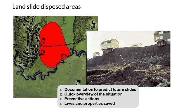
National Geospatial Strategy Related to Natural Hazards and Disasters

                                          Kari STRANDE, Norway

   1. NATIONAL GEOSPATIAL STRATEGY

   1.1 Overall vision and objectives
   Norway has an extensive and advanced foundation for access to geospatial information. This
   is our geospatial data infrastructure. It covers many needs in society and consists of various
   shared solutions for the management, distribution and use of geospatial information. This
   infrastructure has been developed to a great extent through the agreement-based
   administrative cooperation Norway Digital.

   With this strategy, the Government will continue to develop the infrastructure. The strategy is
   based on the fact that “everything happens somewhere”, and it shows the direction of the
   work ahead. The strategy complements Report no. 27 to the Parliament (2015–2016), Digital
   Agenda for Norway – ICT for Simpler Everyday Life and Increased Productivity. This
   strategy essentially builds on a draft from the Coordination Group for Geospatial Information
   and the National Geodata Council. The strategy addresses the sectoral authorities at various
   administrative levels, data producers, technology providers, innovators and users in all sectors
   – and the Norwegian Mapping Authority as the national geospatial coordinator. The
   responsibility for implementing measures in the strategy’s action plan will essentially lie with
   the public sector in accordance with the Act on an infrastructure for geospatial information
   (the Spatial Data Act).

   The vision is: Norway shall be at the forefront in the use of geospatial information.
   The Government will work for
      - A national knowledge base of geospatial information that meets important societal
          needs
      - Shared solutions and technology that support effective problem solving and enable
          new application opportunities in society
      - Well-functioning interaction with respect to management, sharing, development
          and innovation between both public and private actors
      - Framework conditions that are predictable and well suited to the challenges of
          digital society
   The strategy aims at an efficient flow of data between sectors and levels, streamlining data
   capture to the infrastructure, shared solutions for management and utilization of big data
   technology to acquire greater knowledge. The cooperation must meet the new demands and
   there must be appropriate arenas for public-private cooperation. The objectives focus on
   improvements of the basic knowledge foundation, of the technical infrastructure, of

National Geospatial Strategy Related to Natural Hazards and Disasters (11158)
Kari Strande (Norway)
FIG e-Working Week 2021
Smart Surveyors for Land and Water Management - Challenges in a New Reality
Virtually in the Netherlands, 21–25 June 2021
cooperation models, of the framework and of the financing. To follow up the strategy there is
   set up an action plan with about 50 projects that involve several ministries and directorates
   and some private actors. Good interaction will be a success factor for this strategy.

   1.2 Trends
   We live in a digital era, where we rely on geospatial information every single day. Both
   professionals and private individuals use geospatial information to visualise physical
   phenomena and events and increase the value of other information. Geospatial information is
   required to meet social challenges, such as climate change, environmental challenges,
   transport, resource management, emergency planning and urbanisation. Geospatial
   information is also part of many commercial offerings and is an integral part of the digital
   services we all use in everyday life. The creation of value based on geospatial information is
   significant, but there is still a great unused potential here. The needs and demand change over
   time. The development of technology will offer new opportunities and applications such as
   digital twins, here from the city Aalesund developed by Offshore Simulator Centre AS.

   The increased digitalisation in many areas of society provides new opportunities for collation,
   analysis and knowledge production – not to mention sharing, collaboration and interaction
   between actors. In the private sector, geospatial information provides opportunities for more
   efficient operation, digital innovation, and business development. Software solutions and
   services based on geospatial information represent a significant export potential for our
   knowledge-based industries. Global technology and content companies have at the same time
   become major actors in the field, offering many location-based services to the public.
   The United Nations Committee of Experts on Global Geospatial Information Management
   (UN-GGIM) emphasises the importance of a good geospatial knowledge base, in order to
   achieve sustainable development goals. The United Nations has established guidelines on how
   the member states should develop geospatial information, including management solutions
   and infrastructures. The current Norwegian strategy agrees essentially with the United
   Nations initiative in this area.

National Geospatial Strategy Related to Natural Hazards and Disasters (11158)
Kari Strande (Norway)
FIG e-Working Week 2021
Smart Surveyors for Land and Water Management - Challenges in a New Reality
Virtually in the Netherlands, 21–25 June 2021
1.3 Digital geospatial infrastructure
   Norway already has a digital geospatial infrastructure. It consists of large amounts of data,
   collected by many actors from various sectors over a long period of time, and of tools, shared
   solutions, directory services, agreements and routines that have been established to manage,
   locate, distribute and use geospatial information efficiently. However, there is still a way to go
   before the infrastructure can be said to meet the needs of all the important areas of society.
   The amount of digital information in society is growing. Geospatial information is no
   exception.

   Several actors in society use a great deal of resources to collect, maintain and analyse
   geospatial information. Municipal and central government mapping and surveying activities
   amount to more than NOK 2 billion. The private geomatics industry reported revenues of
   more than NOK 2.4 billion around the year 2000. Companies that are primarily aimed at
   special types of mapping, for example, geological and geophysical mapping, are not included
   in this number. Members of the trade association for geomatics companies reported revenues
   of NOK 5.0 billion in 2017, but this number also includes services outside the geomatics area.

   The Norwegian geospatial data infrastructure shall observe the principles that are inherent to
   work on the geospatial data infrastructure in the EU, including, for example, that data shall
   only be collected once, that it shall be stored where it can be the most effective, and that it
   shall be possible to combine the data seamlessly between different application areas. This will
   simplify the reporting for the national, European and global needs.

   A large part of the geospatial information is collected by public actors. A lot of information is
   also created in the private sector on assignments for the public sector, through commercial
   activity or the behaviour of consumers. The rapid digitalisation of society and a growing
   demand brings up the question of how the collection, management, distribution and collation
   of geospatial information should be organised. In some areas, data from the public
   (crowdsourcing) emerges as an important source of data.

   The requirements in and pursuant to the Spatial Data Act govern access to data in the
   geospatial data infrastructure. This applies, for example, to the requirements for
   documentation and open electronic access. Other laws and regulations also set out
   requirements for open data, such as the Freedom of Information Act and Environmental
   Information Act. The Ministry of Local Government and Modernisation’s guidelines for the
   disclosure of public data apply to data in the geospatial data infrastructure. This implies
   essentially that the data is free and freely available for reuse. There are some exceptions,
   including the most detailed geospatial data (Joint Geospatial Database, “FKB”) and precise
   position data, for example. The focus on open public data and reuse is about giving trade and
   industry, researchers and civil society access to data from the public sector in a way that
   allows the data to be used in new contexts.

National Geospatial Strategy Related to Natural Hazards and Disasters (11158)
Kari Strande (Norway)
FIG e-Working Week 2021
Smart Surveyors for Land and Water Management - Challenges in a New Reality
Virtually in the Netherlands, 21–25 June 2021
There are three main reasons why access to open public data is important to society:
   - Streamlining and innovation: When data is shared between enterprises, we obtain
      better interaction, more rational service development and better public services
   - Business development: Trade and industry are given the opportunity to develop new
      services, products and business models based on access to public information
   - An open and democratic society: Access to the basis for making decisions and
      priorities in the public sector provides a better opportunity for obtaining insight into
      how decisions are followed up and what the impact of political actions is

   1.3.1 Public partnership
   The central government and municipalities collect and manage geospatial information that
   represents the foundation of our national knowledge base. The information is used in various
   administrative procedures, but it is also included as part of various public services. Moreover,
   this information is the basis for the creation of value in trade and industry and benefits us all.
   The municipalities are important contributors to, premise providers for and users of the
   knowledge base. They establish, develop, partially finance, and maintain detailed geospatial
   data. The municipalities' administrative data capture covers most of the man-made changes to
   the physical environment. The Norwegian Public Base of Geospatial Data (DOK) is used to
   make decisions, approve applications, prepare and process plans in accordance with the
   Planning and Building Act and to develop local communities.

   There is well-functioning cooperation for the coordinated establishment, management, and
   maintenance of detailed data through cooperative structures such as Geovekst and the
   National Programme for Aerial Photography. In the area of marine mapping, the Mareano

National Geospatial Strategy Related to Natural Hazards and Disasters (11158)
Kari Strande (Norway)
FIG e-Working Week 2021
Smart Surveyors for Land and Water Management - Challenges in a New Reality
Virtually in the Netherlands, 21–25 June 2021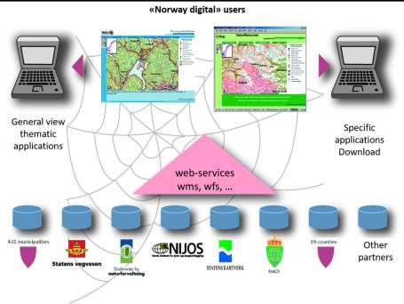
Programme and Marine Coastal Mapping are corresponding examples. Cooperation is both
   socio-economically sensible and necessary. In addition, several international programmes in
   environmental and resource monitoring also contribute a large amount of new data. It is
   expected that international joint initiatives will be of greater importance in the future.
   Copernicus, Europe’s major satellite and sensor-based programme for environmental
   monitoring, climate and civil protection, provides us with data on land use, vegetation
   changes, water quality, weather conditions, air quality, pollution and greenhouse gases. This
   concerns large amounts of data that are now available and must be utilised in a good way,
   which entails new major requirements for the infrastructure for geospatial information.

   1.3.2 External data sources
   Colleges, universities, research institutions and national and international R&D programmes
   create data that will be valuable to decision-making processes and for the creation of value. In
   general, this information is currently not very accessible for reuse. It must be possible to link
   the geospatial data infrastructure to research data to a greater degree. Geo-referenced research
   data could thus become part of our common knowledge base, and the geospatial data
   infrastructure could support research more efficiently in accordance with the national strategy
   for the disclosure and sharing of research data. This goes both ways: The geospatial data
   infrastructure shall be suitable as a source of data for research, and for the archiving and
   disclosure of geospatial related research data.

   Private actors contribute to the production of data through development plans, licence
   applications, impact assessments, environmental assessments or other statutory interaction
   with central government agencies or municipalities. This data must also become an integral
   part of our overall knowledge base to a greater extent. Private companies also establish
   databases for various special purposes, which may encompass general maps of roads,
   topographies, etc. Examples of major global actors who have done this include Google, Apple
   and the map service Here. These actors do not just use detailed basic maps and aerial images,
   they also use three-dimensional terrain models and various types of thematic information.

   Organisations, the voluntary sector and the general public also contribute to the production of
   geo-referenced data, through online voluntary work and interaction with the public sector.
   The infrastructure shall facilitate the utilisation of these contributions in the infrastructure, as
   well as innovation.

   1.3.3 Users' needs and access to data
   The needs of the users and adaptation for a digital first choice must be key to the development
   of the national infrastructure. Authoritative and prioritised data shall be structured,
   documented and offered in accordance with the expectations and user requirements, including
   international requirements. Data that is included in the national infrastructure, but is not
   necessarily defined as part of the prioritised “core data”, shall also be adapted for use by the
   fulfilment of certain requirements (formats, metadata, quality labelling, etc.). Such data may
   have completely different qualities or coverage. Some data may be adapted to the simple

National Geospatial Strategy Related to Natural Hazards and Disasters (11158)
Kari Strande (Norway)
FIG e-Working Week 2021
Smart Surveyors for Land and Water Management - Challenges in a New Reality
Virtually in the Netherlands, 21–25 June 2021
needs of specific user groups, while other data may be used by more groups and subject to
   greater requirements. The infrastructure shall offer three-dimensional data, dynamic data,
   historical data and processed information. Broad utilisation of new technologies shall also be
   facilitated, which also can make the utilisation of big data possible. There shall be a complete
   overview of geospatial information, including the properties and related services in the map
   directory www.geonorge.no.

   A good geospatial knowledge base is essential for well-functioning cities and local
   communities. The building industry is a billion kroner industry that can achieve greater
   predictability, better engineering support and more efficient interaction with the
   municipalities through integrated use of geospatial information. In some areas, new needs
   arise for data other than what has traditionally been used. In other areas, data with an even
   higher degree of detail may be required to solve the tasks or realise the services. Society needs
   good, up-to-date data in private and public activities, within all the specialist areas and
   sectors. Data must be available in ways that meet the needs. The data must have known
   coverage and a quality adapted to the needs of the various actors, so that it can support their
   specific applications and be part of the relevant decision-making processes.

   1.3.4 Technology and tools
   Good tools, methods and a well-functioning technical infrastructure must be in place in order
   to convert data to information and knowledge for practical use.

   The infrastructure must be further developed. The use of standards is key to the infrastructure.
   National standards for geospatial information have long been in widespread use. The national
   standardisation efforts must be developed in accordance with new societal needs, the
   development of new technologies and new international standards. Standards, harmonised
   data formats and concepts, for example, are prerequisites for international cooperation,
   research and problem solving across sectors and national borders.

   Integration between infrastructures, data and services is becoming increasingly important
   Geospatial information is currently integrated to varying degrees with the available IT
   solutions. The lack of suitable user applications is one of our challenges. Global actors now
   offer a growing number of services and information in the “cloud”, which helps increase
   availability and can lower the user threshold. New user platforms and mobile devices,
   however, will entail new requirements for standards and user-oriented services in the
   infrastructure. Geospatial information from the national infrastructure needs to be better
   integrated in the work processes and user tools that are used. The infrastructure and shared
   solutions must interact with commercial software, while the technology is at the same time
   adapted so that it is independent of the platform. The infrastructure shall facilitate fully digital
   and efficient processes, as well as service innovation and good utilisation of the knowledge
   base. As a platform for access to all geospatial information, Geonorge.no will be a source of
   innovative applications for the data content. It must be possible to integrate geospatial

National Geospatial Strategy Related to Natural Hazards and Disasters (11158)
Kari Strande (Norway)
FIG e-Working Week 2021
Smart Surveyors for Land and Water Management - Challenges in a New Reality
Virtually in the Netherlands, 21–25 June 2021
information with other infrastructures and with commercial software, and to handle new data
   capture methods and new types of data.

   Geospatial information systems do not automatically interact with the municipal
   administrative processing and archiving systems. The administrative processing and archiving
   systems are not automatically able to utilise information on geospatial conditions either. The
   Norwegian Mapping Authority and the Norwegian Association of Local & Regional
   Authorities (KS) are cooperating on developing and maintaining common standards and
   principles of this type for interaction between geospatial information systems, other
   professional systems and administrative processing and archiving systems. This applies in
   particular to integration with the land register (cadastre) and systems that the municipalities
   use for building applications and land-use planning. The standards have been developed and
   tested in broad cooperation between the municipalities, suppliers and central government
   agencies.

   Geospatial information will concern more and more actors and must be seen in a broader
   perspective than in the past. To develop content and technology for the benefit of the public
   sector, trade, industry and society as a whole, there is a need for greater cooperation between
   all actors than has previously been achieved.

   1.4 Framework conditions
   Development of the geospatial data infrastructure is part of the Government's efforts to
   digitalise and streamline the public sector. Collecting and managing data is often associated
   with high costs. This means that as much as possible must be gained from the combined
   efforts through cooperation. Central government agencies have a self-defined need for
   specific data within their areas of responsibility and manage their own investments

National Geospatial Strategy Related to Natural Hazards and Disasters (11158)
Kari Strande (Norway)
FIG e-Working Week 2021
Smart Surveyors for Land and Water Management - Challenges in a New Reality
Virtually in the Netherlands, 21–25 June 2021
accordingly. The municipalities establish data to exercise their role as a service provider and
   exerciser of authority, for example in the form of municipal master plans, detailed technical
   maps.

   The financing of the infrastructure is partly through ordinary appropriations, government
   charges for acts by public authorities and revenue from the sale of data. In addition, various
   forms of co-financing by the participants in the infrastructure play a large role, through
   structures such as Geovekst and Norway Digital, for example. A new elevation data model is
   a recent example of broad co-financing from several sectors. These agreement-based co-
   financing schemes have been effective because it has contributed to the ownership of needs,
   and that they have distributed the risk among several actors. However, it is a question of
   whether such measures alone are sufficient as funding mechanisms for critical societal
   infrastructure. The funding mechanisms that support the strategy and provide security for all
   the actors will be studied more closely.

   The public sector will continue to bear the brunt of the financing of the geospatial data
   infrastructure. Collecting, maintaining, and managing geospatial data is associated with
   relatively large costs. This is especially true regarding the most detailed data. At the same
   time, the demand for such data is increasing because of the digitalisation of society. Even
   though new data capture methods and new technologies streamline data production, we must
   expect that the cost of data collection, maintenance and management will increase compared
   to today’s levels.

   The fact that the geospatial data infrastructure is critical for many societal functions calls for
   assurance of the necessary financing of new data, ongoing operations and maintenance of the
   data content and related services. This is safeguarded today to a great extent through the
   budgets of the public sectoral agencies or through a sharing of expenses by the actors who see
   a common benefit of the investments. From experience, cooperation, sharing expenses and
   joint investments in data capture and maintenance programmes have proven to safeguard the
   priorities of key users and provide good utilisation of the actors’ combined resources. It is not
   given that this is a sufficiently predictable structure for the future.

   A fundamental problem is that the benefits of high-quality data are often realised by parties
   other than those who have incurred the expenses. Even though free access to the best data is
   expected in isolation to be socio-economically beneficial, the actor in question does not
   necessarily have the economy to pay for all the costs associated with collecting and
   maintaining data with a high level of detail or quality.

   2. NATURAL HAZARDS, DISASTERS AND GEOSPATIAL INFRASTRUCTURE

   New threats and vulnerabilities arise. The prerequisites for food production and food safety
   are gradually changing. Climate change affects the probability and consequences of natural

National Geospatial Strategy Related to Natural Hazards and Disasters (11158)
Kari Strande (Norway)
FIG e-Working Week 2021
Smart Surveyors for Land and Water Management - Challenges in a New Reality
Virtually in the Netherlands, 21–25 June 2021
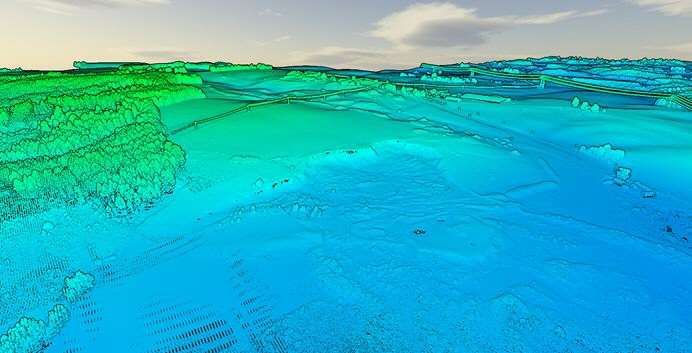
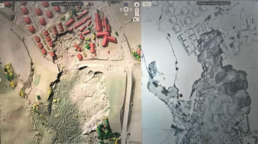
events such as floods, landslides, extreme weather, and storm surges. Local authorities must
   take this into account, including in spatial plans. The municipalities and counties have
   obligations in ensuring a climate-adapted society. The requirements for good emergency
   planning for serious incidents are increasing, and the ability to handle crisis situations
   becomes more and more important. Risks and vulnerability analyses is important for
   preparedness for climate-related natural damage.

   Geospatial information is required to meet social challenges, such as climate change,
   environmental challenges, transport, resource management, emergency planning and
   urbanisation. Geospatial information is an important element of work with adaptation to
   climate change and other environmental challenges, including land-use planning by the
   municipalities. Updated geospatial information is necessary for the assessment of threat
   situations and the ability to act quickly and appropriately.

   2.1 Risk management:
   Norway is exposed for natural disasters like landslide, rockslide, snowslide, underwater slide
   and slide as a cause of flood or tsunami. 2000 killed by natural disasters the last 150 years. It
   is expected 10 bigger slides in the coming 50 – 100 years, each with 10 – 100 persons dead

   The municipalities in Norway have great responsibility and authority to develop the local
   society and the framework to secure the inhabitants. The situation varies form big cities with
   air pollution, mountain areas with avalanches, built up areas on quick clay, coastal areas
   where weather conditions can be a challenge and where grounding or oil spill can create local
   pollution. It is important to build on knowledge about local conditions and make the spatial
   planning, preparedness work and climate adaption suitable for the local situation.

   Evaluation of Risk and Vulnerability are obligatory tasks for the municipalities and are
   integrated in Spatial Planning and Environment Impact Assessment. Mapping of potential
   risks is essential and must build on updated knowledge and experience. Risk and vulnerability
   analyses may help avoiding building in area exposed for flood, avalanche, radon, and
   pollution. The Norwegian Public Base of Geospatial Data (DOK) is central for the knowledge
   and it is of great importance that the data is updated and easily available.

   Some causes for unexpected occurrences are nature conditions as extreme weather, natural
   hazards and pandemics. Several datasets and actors play important roles to prevent natural
   disasters. If a civil emergency system is implemented, The Norwegian Mapping Authority is
   collaborating with regional authorities through its regional offices and directly with the
   Armed Forces' military geographical service. Following flood and landslide events, the
   Mapping Authority assists with new data capture and uses its framework agreements to order
   aerial photography or laser scanning of affected areas. This was done during some flood and
   landslide disasters the last years. The picture here is a model of the actual landslide area in
   2016, measured with laser shortly after the landslide. It shows that large masses have
   collapsed and we can also discover vegetation and high voltage lines in the model.

National Geospatial Strategy Related to Natural Hazards and Disasters (11158)
Kari Strande (Norway)
FIG e-Working Week 2021
Smart Surveyors for Land and Water Management - Challenges in a New Reality
Virtually in the Netherlands, 21–25 June 2021
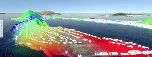
2.2 Relevant datasets and services for natural hazards and disasters
   There will be a need for documentation on possible exposed areas to be available for
   preparedness and prevention. If a situation occurs there will be a need for a quick overview of
   the situation and especially about the possibility of saving life and property.

   2.2.1 Laser data
   Laser data gives new opportunities to evaluate the risk for landslide, it shows rivers and
   streams more exactly and gives better knowledge for future protection against rock and
   landslides. Laser data is used to create detailed elevation model and also terrain model.
   Such measurements are carried out with aircraft flying at low altitude or drones sending laser
   beams down to the ground and measuring altitude and position with very high precision. This
   dataset is, like the rest of the model, freely available online in Norway at https://hoydedata.no

   The need for such models is to get an overview of landslide volume and distribution for
   original terrain. A detailed model is also relevant to look for victims and during a rescue
   situation to overview changes in the masses. Furthermore, the laser data are useful for the
   work of reopening the river course.

   2.2.2 The Norwegian Public Base of Geospatial data (DOK)
   DOK consists of basic datasets that are defined as central for all spatial planning, risk
   management, building and construction. It is defined in the Plan- and building Act with
   additional regulations. The list of datasets is updated every year and approved by the Ministry
   of Local Government and modernisation. For 2020 it consists of 148 datasets. The most basic
   datasets are a collection of the most detailed map data in Norway also called the Core
   Database (FKB). This database is collected and managed in close cooperation between the
   municipalities and various governmental institutions. Also, various thematic datasets are

National Geospatial Strategy Related to Natural Hazards and Disasters (11158)
Kari Strande (Norway)
FIG e-Working Week 2021
Smart Surveyors for Land and Water Management - Challenges in a New Reality
Virtually in the Netherlands, 21–25 June 2021
included in DOK. Datasets of more importance for Risk management is administrative units,
   lakes and rivers, groundwater, roads, buildings, addresses, properties, power lines,
   orthophoto, bathymetric data, utilities, facilities with dangerous substances, facilities with
   explosives. Also, special caution maps are included in DOK like caution maps for flood,
   quick clay, avalanche, and landslide.

   2.2.3 Other important datasets for hazard and disaster management.
   In addition to the Digital Elevation Model (DEM) and the caution maps, the mapping of
   catchment areas, river network and runoff is og great value. Earth observation is another
   source and Norway is a large consumer of earth observation from sea, land and air. We use
   earth observation for weather and climate prediction, for ship detection, for oil spill detection,
   to follow the outspread for snow, ice, glacier, and permafrost and to monitor landslide.

   2.3     Public and private services to assist in disaster prevention and management.
   The Norwegian Water Resource and Energy Directorate (NVE) has a special role for
   preparedness for avalanche, flood and landslide and produce regularly forecast at a webpage
   www.varsom.no. NVE has the responsibility for mapping and map services regarding
   avalanche, floods and landslides. They make caution maps for quick clay with several levels.
   Level 1 show all areas under marine border, level 2 shows potential marine clay based on the
   quaternary geology maps. Level 3 is the regional mapping program with new mapping to
   point out zones of potential danger for quick-clay and for bigger quick-clay avalanche.
   Included in the mapping here is also ground drilling based on terrain evaluation. Level 4 is
   more detailed mapping of the zones exposed for quick clay. This include an assessment of the
   real security for the zones with more ground drilling and stability calculations in several
   critical cut. The main objectives for the mapping is to be used in Spatial planning and
   assessment of construction activities and for assessment of security precautions in existing
   built-up area. The Caution mapping have the objective to define areas where the danger must

National Geospatial Strategy Related to Natural Hazards and Disasters (11158)
Kari Strande (Norway)
FIG e-Working Week 2021
Smart Surveyors for Land and Water Management - Challenges in a New Reality
Virtually in the Netherlands, 21–25 June 2021
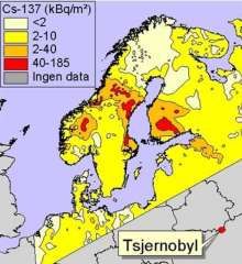
be closer assessed before new constructions and for observation for terrain intervention. The
   detailed mapping serves as knowledge base for NVEs advice to municipalities and
   constructors in spatial planning and engineering.

   Some private companies have developed systems and tools to assist disaster management,
   both with data capture, data management, data connect and integrate and systems for
   detection and analyses. One example is the online viewer MAPSPACE from Terratec AS.
   This system gives the possibility to look at orthophoto, vertical picture, street views, laser
   data, point clouds, mapping etc. www.mapspace.com. The system offers a wide set of APIs,
   GPS plug-in and tools for combining data from various sources. They have made
   demonstrations of how they captured new laser data and assisted with management tools for
   geologists with combined information in the days after the latest quick clay land slide in
   Gjerdrum December 30, 2020.

   2.3.1 Risk reduction, preparedness and management.
   There is little to do to prevent the natural hazards, however, we can be prepared for situations
   and for reducing the impact of natural hazards. By modelling potential scenarios and
   assessment for localization of high exposed risk areas. There can be made risk reducing
   actions including warning systems. Decisions made today will influence the future
   vulnerability of the society. Greater emphasis is needed on a good knowledge base and
   regional climate profiles with information. When planning new areas for development,
   densification and transformation, there must be realistic mapping of potential danger, risk and
   vulnerability. Good spatial planning is important to avoid constructions in areas that are
   exposed for flood, landslide, avalanches, acute polution, or other natural threats.

   The use of mapping and GIS analysis is important to know about avalange danger, potential
   release and outlet area, tidal waves etc. Further geodata it is important for R&V analysis and
   for spatial planning. It is needed to be on alert and for evacuation planning. In an actual
   occurence there is a need to know about spare roads, detours and load capacity. Measures to
   secure electricity and telecommunication, including power to base stations. There is also a
   need for communication staff to have access to, and to be able to utilize the map systems for
   location of events, coordination of measures and delimination of areas with different levels of
   danger. Mapping and GIS is also used to assist the geologists' work after a landslide.
   Some challenges is still to be looked into. How is the data access, which data are available,
   what is the quality. Is there restriction for use, how can the data be easily shared.

   2.3.2 Map, geodata and GIS in disaster management – some examples.
   The Chernobyl disaster in April 1986 was the worst nuclear disaster both in terms of cost and
   casualties. It involved more than 500.000 people. The outspread of Caesium-137 caused
   contamination also in Norway. The contamination is expected to be seen for further 100
   years. To be able to follow the outspread at an early stage GIS analysis were used based upon
   weather conditions, wind directions, rainfall in the days after the accident it was possible to
   find the most exposed areas. With these analyses supplied with in site measures it was

National Geospatial Strategy Related to Natural Hazards and Disasters (11158)
Kari Strande (Norway)
FIG e-Working Week 2021
Smart Surveyors for Land and Water Management - Challenges in a New Reality
Virtually in the Netherlands, 21–25 June 2021
possible to find which area were most contaminated and put up measures to secure healthy
   sheep meat. Shortly after the accident, it was increasing levels of caesium in sheep, goats and
   cows in some places in Central Norway. Reindeer were also affected.

   Location of source of infection - Legionella-epidemic 2005
   By use of geoinformation and GIS analysis, information on addresses for patiensts and
   possible sources of infection within a 3 km buffer, and movements pattern for actual patiens it
   was possible to detect the source of the outbreak of a legionella epidemic in 2005.

   The landslide in Gjerdrum 30. December 2020. It was one of the largest quick clay slides in
   Norway. The slide started several hundred meters south of the built-up area and came step by
   step closer to the built-up area. 100 meters of the road was also gone. Almost 1000 people
   were evacuated, and 10 people lost their lives in the avalanche area. The slide took 10 houses
   with 31 family units. It was close to a home for elderly people. Three farms were affected.
   The following days there were also smaller slides.
   The home for elderly people were evacuated, the children school, the medical centre, the city
   hall, and the kindergarten were closed. Electricity, water supply and sewage were out of order
   as caused by the slide. Many experts were involved in the management and search for lost
   people and several of the data and tools mentioned were used to assist the management.

National Geospatial Strategy Related to Natural Hazards and Disasters (11158)
Kari Strande (Norway)
FIG e-Working Week 2021
Smart Surveyors for Land and Water Management - Challenges in a New Reality
Virtually in the Netherlands, 21–25 June 2021
REFERENCES:
   Ministry of Local Government and Modernisation, National geospatial strategy towards 2025,
   published 10/2018 Everything happens somewhere (regjeringen.no)
   The Norwegian Water Resources and Energy Diretorate (NVE) - Map services - NVE
   Terratec AS, system MAPSPACE launched 11/2020 Mapspace User Manual

   BIOGRAPHICAL NOTES
   Educated surveyor with additional education in architecture and law studies.
   Delegate to commission 3 since 201 with several papers at congresses and WW.
   Editor of several publications about Map and use og Maps.
   Leading positions from municipalities, regional planning and Norwegian Mapping Authority.
   Deputy director general at Ministry of Local Government and Modernization
   Chaired exchange program for young surveyors between Vietnam, Laos and Norway 2001-
   2009 and have worked with Norwegian Agency for Development Cooperation.

   CONTACTS
   Kari Strande
   Lars Mikkelsensvei 4, 3531 Krokkleiva,
   NORWAY
   Tel. +47 90996515,
   Email: kar-st@online.no

National Geospatial Strategy Related to Natural Hazards and Disasters (11158)
Kari Strande (Norway)
FIG e-Working Week 2021
Smart Surveyors for Land and Water Management - Challenges in a New Reality
Virtually in the Netherlands, 21–25 June 2021
You can also read