D3.1 Big Data Toolbox I - WP3 - Large Scale Demonstrators - Parsec Accelerator
←
→
Page content transcription
If your browser does not render page correctly, please read the page content below
–

         D3.1 Big Data Toolbox I
       WP3 – Large Scale Demonstrators

    Authors: Dimitar Misev, Peter Baumann, Gedas Vaitkus
                           Date: 11.02.20

       This project has received funding from the European Union’s Horizon 2020
       research and innovation programme under grant agreement No 824478.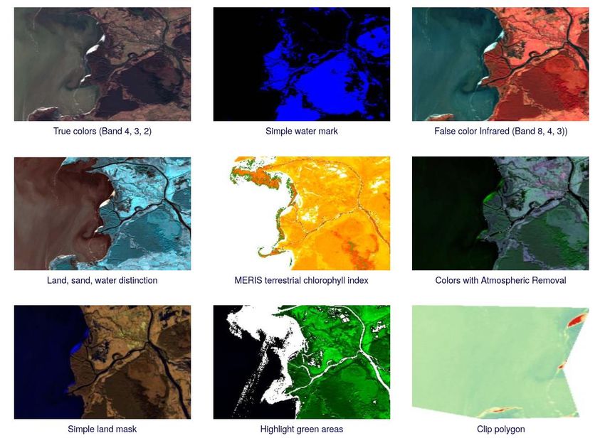
D3.1 Big Data Toolbox I

Full Title             Promoting the international competitiveness of European Remote Sensing
                       companies through cross-cluster collaboration
Grant Agreement No 824478                         Acronym                 PARSEC

Start date             1st May 2019               Duration                30 months

EU Project Officer     Milena Stoyanova

Project Coordinator    Emmanuel Pajot (EARSC)

Date of Delivery       Contractual        29.02.2020         Actual             26.02.2020

Nature                 Other                      Dissemination Level     Public

Lead Beneficiary       RASDAMAN

Lead Author            Dimitar Misev              Email                   misev@rasdaman.com

Other authors          Peter Baumann (RASDAMAN), Gedas Vaitkus (GEOMATRIX)

Reviewer(s)            Ola Majorczyk (EVERSIS)

Keywords               big data, EO, datacubes, array databases, OGC services, rasdaman, sagris

Document History
Version    Issue date      Stage           Changes                            Contributor
1.0        11.02.2020      Draft           First draft                        RASDAMAN,
                                                                              GEOMATRIX
1.1           26.02.2020   Draft           Merge review commonts              EVERSIS,
                                                                              RASDAMAN

Disclaimer
Any dissemination of results reflects only the author’s view and the European Commission is not
responsible for any use that may be made of the information it contains

Copyright message
© PARSEC consortium, 2020
This deliverable contains original unpublished work except where clearly indicated otherwise.
Acknowledgment of previously published material and of the work of others has been made
through appropriate citation, quotation or both. Reproduction is authorised provided the source
is acknowledged.

                                                                                        Page 2 of 26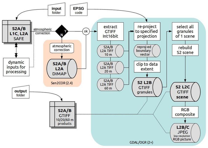
D3.1 Big Data Toolbox I

Table of Contents
List of Acronyms ....................................................................................................................................... 5
Executive Summary .................................................................................................................................. 6
1      Introduction ..................................................................................................................................... 7
2      Rasdaman ......................................................................................................................................... 8
    2.1        Client-server architecture ........................................................................................................ 9
    2.2        Software requirements .......................................................................................................... 12
    2.3        Hardware requirements......................................................................................................... 13
    2.4        Main features ......................................................................................................................... 13
    2.5        Operating instructions ........................................................................................................... 14
3      SAGRIS ............................................................................................................................................ 16
    3.1        Binary pre-processors ............................................................................................................ 16
    3.2        Software requirements .......................................................................................................... 17
    3.3        Hardware requirements......................................................................................................... 18
    3.4        Main features ......................................................................................................................... 18
    3.5        Data products ......................................................................................................................... 19
    3.6        Processing workflows............................................................................................................. 19
    3.7        Operating instructions ........................................................................................................... 23
4      Big Data Toolbox Prototype ........................................................................................................... 24

Table of Figures
Figure 1 High-level overview of the PARSEC Big Data Toolbox. .............................................................. 7
Figure 2 More detailed overview of the integration of SAGRIS pre-processors, external datasets and
PARSEC platform, powered by rasdaman. ............................................................................................... 8
Figure 3 Rasdaman client-server architecture ......................................................................................... 9
Figure 4 Ingestion process with wcst_import.sh ................................................................................... 10
Figure 5 Detailed architecture diagram of rasdaman. ........................................................................... 11
Figure 6 Sentinel-1 pre-processing workflow: load the original SAFE package → calibrate, flatten and
orthorectify with SNAP into DIMAP package → transform DIMAP into 16-bit GeoTIFF using GDAL →
apply user-specified EPSG projection using GDAL → produce false col ................................................ 21
Figure 7 Sentinel-2 pre-processing workflow: load original (orthorectified) SAFE package (a single
Sentinel-2 granule) → apply atmospheric correction (if it is L1C product) with Sen2Cor and produce
an L2A processing level SAFE package → transform SAFE package into 10m, 20m and 60m resolution
16-bit GeoTIFF images using GDAL → apply user-specified EPSG projection using GDAL → produce
false color composite image from spectral bands. ................................................................................ 22
Figure 8 Big Data Toolbox demo entry page showcasing the WMS service on 3D time-series Sentinel-2
data. ....................................................................................................................................................... 24

                                                                                                                                            Page 3 of 26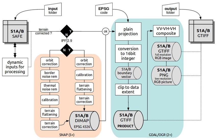
D3.1 Big Data Toolbox I

Figure 9 Various examples of Sentinel-2 time-series data processing, fusion and summarization with
OGC WCPS queries. ................................................................................................................................ 25

Table of Tables
Table 1 Hardware requirements. ........................................................................................................... 13
Table 2 Installation directory structure. ................................................................................................ 14
Table 3 rasdaman executables............................................................................................................... 14
Table 4 rasdaman configuration files..................................................................................................... 15

                                                                                                                                   Page 4 of 26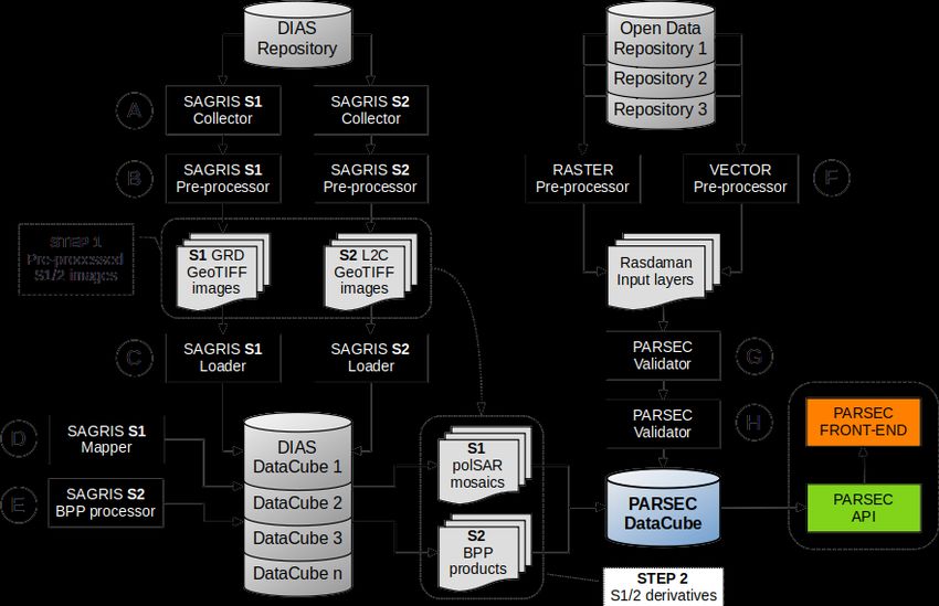
D3.1 Big Data Toolbox I

List of Acronyms
API    Application Programming Interface
CRS    Coordinate Reference System
EO     Earth Observation
OGC    Open Geospatial Consortium
WMS    Web Map Service
WCPS   Web Coverage Processing Service
WCS    Web Coverage Service

                                                        Page 5 of 26
D3.1 Big Data Toolbox I

Executive Summary
This report documents the PARSEC Big Data Toolbox for management and access of spatio-temporal
data, based on the rasdaman datacube engine and the SAGRIS data pre-processing suite. The Toolbox
offers access to large EO data (primarily Sentinel-1 and 2, plus further types of data as needed) via
standard OGC datacube API, namely WCS, WCPS, and WMS.

First the overall platform design and architecture of the Big Data Toolbox are presented. This is
followed by comprehensive sections on rasdaman and SAGRIS, covering details from architecture and
main features, to software / hardware requirements for deployment and administration instructions.
Finally, the first prototype of the Big Data Toolbox is briefly showcased.

                                                                                        Page 6 of 26
D3.1 Big Data Toolbox I
1 Introduction
The PARSEC Big Data Toolbox consists of many components working together to offer flexible and
fast access to analysis-ready EO datacubes. The primary technologies behind the scene are rasdaman,
a pioneering engine for scalable datacube management, and SAGRIS, a powerful EO data pre-
processing toolbox primarily applied to Sentinel data products.
Data on local or network filesystem, including pre-processing results from SAGRIS, is ingested or
registered as datacubes in rasdaman via WCS-T. The datacubes are subsequently made available via
standard OGC interfaces: WCS, WCPS, and WMS (Figure 1).
Figure 1 High-level overview of the PARSEC Big Data Toolbox.
The current deployment scenario assumes that SAGRIS and PARSEC platform are deployed on
different DIAS platforms, so that satellite image and external data pre-processing is done separately
from rasdaman in order to increase service scalability and reduce processing loads on the main
PARSEC service container (Figure 2).
Page 7 of 26D3.1 Big Data Toolbox I
Figure 2 More detailed overview of the integration of SAGRIS pre-processors, external datasets,
and PARSEC platform, powered by rasdaman.
The following sections dive deeper into the architecture of rasdaman and SAGRIS and showcase a
prototype Big Data Toolbox currently deployed on a GEOMATRIX server. Deployment on a DIAS
(Mundi) is in progress.
2 Rasdaman
The goodies of database technology for building flexible, large-scale data management systems are
widely known:
• information integration brings better consistency and much easier administration;
• flexibility by replacing static APIs by dynamic query languages;
• scalability achieved through advanced storage and processing techniques;
• maturity of decades of development focused on data integrity and functionality richness.
Unfortunately, these advantages until recently could be reaped only for alphanumeric data types.
Support for raster EO data in particular (also known as datacubes, multidimensional arrays, gridded
data, sampled data, etc.) has been missing from traditional databases.
This gap is closed by the rasdaman technology which offers distinct datacube management features.
Its conceptual model supports arrays of any number of dimensions and over virtually any cell (“pixel”,
“voxel”) type. The rasdaman query language, rasql, is crafted along standard SQL and gives high-level,
declarative access to any raster data; recently, it has been standardized as ISO SQL/MDA. Its
architecture principle of tile stream processing, together with highly effective optimizations, has
Page 8 of 26D3.1 Big Data Toolbox I
proven scalable into multi-Petabyte object sizes. Rasdaman has been developed since 1996 and has
reached a high level of maturity with operational use since many years.
Technically, rasdaman is a domain-neutral array DBMS, which makes it suitable for application in all
domains where multidimensional array data is of relevance. Especially EO spatio-temporal data is
well supported out of the box, with compliant interfaces for OGC WCS, WCPS, and WMS.
2.1 Client-server architecture
Rasdaman runs as a server that takes care of data management and processing; clients connect to via
HTTP(S) to submit queries to the server and retrieve processing results (Figure 3). A large variety of
clients speak the OGC WCS/WMS language and are hence compatible with the rasdaman server; see
the companion D3.2 Big Data Toolbox Training Manual I document for a detailed overview.
Figure 3 Rasdaman client-server architecture.
The data administrator is responsible for registering data into rasdaman datacubes. For this purpose,
usually the user-friendly wcst_import tool is used. Parameterized with a JSON configuration
(ingredient) file, it takes care of generating standard-compliant WCS-T requests to petascope, the
OGC coverages front-end of rasdaman (Figure 4). Petascope is itself a server, but technically also a
Page 9 of 26D3.1 Big Data Toolbox I
client of the rasdaman core server. It translates the geo-rich OGC requests into domain-neutral rasql
queries, which are then evaluated by rasdaman.
Figure 4 Ingestion process with wcst_import.sh.
Figure 5 shows a detailed architecture diagram of all client and server components; it is especially
relevant to server administrators and client developers interacting with the rasdaman client API.
Page 10 of 26D3.1 Big Data Toolbox I
Figure 5 Detailed architecture diagram of rasdaman.
Page 11 of 26D3.1 Big Data Toolbox I
2.2 Software requirements
Rasdaman can be deployed on a variety of Linux distributions. Tested and supported with standard
DEB and RPM packages are Ubuntu 16.04 / 18.04, and CentOS 7.
Dependencies
During installation, the packages automatically pull required dependencies to be installed as well:
General libraries
• libsqlite, libsqlite-dev, sqlite3 – required for storing arrays in a filesystem directory and the
rasdaman technical metadata in SQLite;
• libssl-dev, libncurses5-dev, libedit-dev, libboost-dev (v1.48+), libffi-dev – required for various
system tasks.
Data encoding/decoding
• libgdal-dev – required for data format support (TIFF, JPEG, PNG, etc.);
• libhdf4g-dev – required for HDF4 support;
• libnetcdf-dev, python-netcdf4 – required for NetCDF support;
• libgrib-api-dev, libgrib2c-dev, python-grib - for GRIB data support;
• libtiff-dev, libjpeg-dev, ligpng-dev - internal encoder/decoder implementations for TIFF, JPEG,
or PNG formants.
Geo data support
• Tomcat (or another suitable servlet container) – required for running the petascope and
SECORE Java web applications, unless they are configured to start in standalone mode;
• python-dateutil python-lxml python-pip python-gdal python-glob2 python-magic netcdf4-
python (required by wcst_import, a tool for importing geo-referenced data into rasdaman /
petascope).
Installation on-premise
In PARSEC, rasdaman will be available as a Big Data Toolbox service for usage by stakeholders.
However, installation on-premise is always possible as well if required, e.g. after the project finishes
or if deployment of custom / proprietary data is necessary. Both the open-source rasdaman
community and the more scalable and feature-rich rasdaman enterprise are straightforward for
deployment on the supported platforms; on request, support for further platforms could be
considered.
Network configuration
For deployment, rasdaman will require some ports to be open on the machine. At a minimum, the
Tomcat service with OGC interfaces needs to be exposed publicly; by default, this is port 8080;
however, it is recommended to use port 80 instead if possible as on many networks only this port will
be open. If rasdaman is to be connected into a federation, then furthermore ports 7000-7020 or so
Page 12 of 26D3.1 Big Data Toolbox I
will need to be opened, so that communication with other rasdaman servers in the federation is
possible.
2.3 Hardware requirements
Rasdaman is not resource-intensive on its own, and hardware requirements are guided mainly by
data volume. For a large public service used by multiple clients, the following recommendation can
be made:
Resource type Recommendation
CPU Min. 8-core
Main memory (RAM) Min. 64 GB
Local disk Min. 1 TB
Table 1 Hardware requirements.
2.4 Main features
Datacube building
Building raster datacubes of any dimension is supported; usually this means time-series, occasionally
2D mosaics. "Building" a datacube means one of
• data ingestion: decode, partition, compress and index data internally = slower building
process, very fast querying
• data registration: index only links to the data = very fast building process (D3.1 Big Data Toolbox I
Support for fine-grain access control based on triggers, along with limits on how much data can be
accessed or transferred; support for user quotas is in the works.
2.5 Operating instructions
Once rasdaman has been installed, a rasdaman service script allows starting/stopping or checking the
status:
$ service rasdaman start
$ service rasdaman stop
$ service rasdaman status
Similarly, the tomcat and postgresql services can be started and stopped. Note that rasdaman runs
with non-root user rasdaman. By default, rasdaman is installed in /opt/rasdaman with the following
directory structure:
Directory Description
bin rasdaman executables, e.g. rasql, start_rasdaman.sh, …
Path where the server stores array tiles as files; this directory can get big, so
data
it is recommended to make it a link to a sufficiently large disk partition.
etc Configuration files, e.g. rasmgr.conf
Include C++ API development headers.
lib C++ and Java API libraries.
log rasmgr and rasserver log files.
Various artefacts like documentation, python/javascript clients, example
share
data, migration scripts, etc.
Table 2 Installation directory structure.
The table below lists the rasdaman executables and scripts found in the bin directory.
Directory Description
rasserver Client queries are evaluated by a rasserver worker process.
A manager process that controls rasserver processes and client/server
rasmgr
pairing.
rascontrol A command-line frontend for rasmgr.
A command-line client for sending queries to a rasserver (as assigned by
rasql
the rasmgr).
Tool for convenient and flexible ingestion of geo-referenced data into
wcst_import.sh
petascope.
Table 3 rasdaman executables.
Server rasdaman configuration files can be found in the etc directory. The configurations are
automatically loaded upon rasdaman start. After any modification, a restart must be performed for
the change to take effect.
Page 14 of 26D3.1 Big Data Toolbox I
Directory Description
allows fine-tunning the rasdaman servers, e.g. number of servers, names,
rasmgr.conf
database connection, etc.
set petascopehttp://rasdaman.org/wiki/PetascopeUserGuide properties,
petascope.properties e.g. database/rasdaman connection details, CRS resolver URLs, various
feature options
secore.properties secore (CRS resolver) configuration
log-rasmgr.conf configure log output of rasmgr
log-server.conf configure log output of rasservers
log-client.conf configure log output of clients (e.g. rasql)
Table 4 rasdaman configuration files.
The rasdaman log files are found in the log directory. The server components feed the following files
where uid represents a unique identifier of the process, and pid is a Linux process identifier:
• rasserver...log: rasserver worker logs: at any time several rasservers are running
(depending on the settings in rasmgr.conf) and each has a unique log file.
• rasmgr..log: rasmgr log: there is only one rasmgr process running at any time.
• petascope.log, secore.log: petascope and secore log files, if the paths are correctly configured
in petascope.properties and secore.properties.
Page 15 of 26D3.1 Big Data Toolbox I
3 SAGRIS
Extraction of business intelligence information on the lowest level of sampling units (agriculture
parcels, forestry blocks, etc.) from standard Sentinel-1 and Sentinel-2 products demands high
positional accuracy and low distortion of the satellite signal, which is only possible with precise
calibration and ortho-rectification of satellite imagery. On the other hand, those are the most
processing-intense remote sensing operations – therefore, we designed a series of binary processors
for a cloud-based production environment, which enables scaling of parallel processing tasks and
using local repositories of satellite images.
Careful pre-processing of Sentinel-1 and 2 products ensures spatio-temporal consistency and
thematic accuracy of sampled business intelligence data; therefore, we primarily focus on the
usability of satellite data products delivered by the SAGRIS workflow, offering a series of practical and
efficient solutions:
• Instead of using generic Range Doppler Terrain Correction and despeckling of Sentinel-1
products, we perform full-scale terrain flattening and ortho-rectification with high-resolution
DEM and preserve the original polSAR back-scatter values;
• Instead of using a collection of partially overlapping Sentinel-2 granules, we transform
granules into a single projection, reconstruct seamless single-pass scenes, bind them into a
consistent time-series and only then perform sampling of per-parcel spectral information;
• Instead of using the default 64-bit data depth for Sentinel-1 data products, we multiply by
1000 and convert to 16-bit integers, thus reducing the size of pre-processed imagery by 5
times and speeding up the further processing operations, which have to deal with integer
values instead of floats.
3.1 Binary pre-processors
For PARSEC data pre-processing, we propose 3 binary SAGRIS processors, designed for pre-processing
of standard Sentinel-1 and 2 products provided by ESA in Standard Archive Format for Europe (SAFE1)
format into production-ready standard GeoTIFF2 data format Sentinel-1 and Sentinel-2 products:
1. Sentinel-1 pre-processor
2. Sentinel-2 pre-processor
3. Sentinel-2 image aggregator
All SAGRIS processors are designed as “headless” stand-alone programs to be executed as separate
commands or in an iterative batch mode combined with input/output parameters.
Sentinel-1 and 2 pre-processors have built-in capabilities of iterative scanning of input folders and
detecting newly uploaded input files, as well as iterative scanning of the output folder and detection
1
https://www.eumetsat.int/website/home/Data/Products/Formats/SentinelFormats/index.html
2
http://www.gdal.org/frmt_gtiff.html
Page 16 of 26D3.1 Big Data Toolbox I
of the newly dumped pre-processed images, which enables operational flexibility of parallel
implementation of multiple dynamic “sub-processes” sharing the same processing batch.
Sentinel-2 pre-processor has a built-in capability of detection standard processing levels (L1C and
L2A) provided by ESA; therefore, it will skip the time-consuming Atmospheric Correction phase of L1C
product in case if corresponding L2A product is already available in the same input folder (per sub-
process). In the same way, to save processing time, the Sentinel-1 pre-processor will skip the most
time-consuming SNAP processes (calibration, terrain flattening, ortho-rectification) in case if a pre-
processed BEAM DIMAP3 data package is available in the output folder. This allows for a rapid
production of large-scale seamless Sentinel-1 data coverages in different plain projections using the
same archive of pre-processed Sentinel-1 DIMAP products.
Sentinel-2 image aggregator has a built-in capability of aggregation separate pre-processed granules
(Sentinel-2 L2B) into seamless satellite passes (Sentinel-2 L2C).
Both Sentinel-1 and Sentinel-2 pre-processors offer functionality for dividing large regions into
production tiles (both Sentinel-1 and 2 processors), which enables scaling the production into
continental and even global extents.
3.2 Software requirements
All binary processors are developed on the Linux operating system platform and they require Linux
system components to operate properly, so essentially, those binaries are exclusive Linux binary
programs. We recommend Ubuntu 16.04 LTS Server4 64-bit operating system (stand-alone or Virtual
machine) as the production platform. On the operating system level, all binary programs require
Python 2.7 platform to be installed on the processing servers or virtual machines.
Sentinel-1 pre-processor is based on standard open-source software components: ESA SNAP5 version
5+ (recommended version 7.x), GDAL6/OGR7 version 2.x and dans-gdal-scripts8 for certain non-
essential operations. ESA SNAP software should include only SNAP9, S1TBX10 and S2TBX11
components. The only SNAP component used by Sentinel-1 binary pre-processor is Graph Processor
GPT; therefore, no SNAP GUI is needed for software operation. This suggests that whenever standard
“headless” SNAP instances are available, the processors could be deployed there. Due to inefficient
use of hardware resources by Java platform powering ESA SNAP software, Sentinel-1 pre-processing
workflow had to be split into separate functional steps and hard-coded into the software, therefore,
currently it is not possible to manipulate the pre-processing algorithms with the help of external
Graph.xml file.
3
https://www.brockmann-consult.de/beam/doc/help/general/BeamDimapFormat.html
4
https://www.ubuntu.com/download/server
5
http://step.esa.int/main/toolboxes/snap/
6
http://www.gdal.org/gdal_utilities.html
7
http://www.gdal.org/ogr_utilities.html
8
https://github.com/gina-alaska/dans-gdal-scripts
9
https://github.com/senbox-org/snap-desktop
10
https://github.com/senbox-org/s1tbx/tree/6.x
11
https://github.com/senbox-org/s2tbx/tree/6.x
Page 17 of 26D3.1 Big Data Toolbox I
Sentinel-2 pre-processor is based on standard open source software components: ESA Sen2Cor12
(recommended version 2.5.5), GDAL/OGR version 2.x and dans-gdal-scripts13 for certain non-essential
operations. Sen2Cor older versions (e.g. 2.3.x) are based on multi-platform Python 2.7
implementation, and Anaconda214 had to be installed in the users [home] directory before
deployment of the Sen2Cor software component. This was rather inconvenient due to large size and
separate maintenance of the Anaconda2 software component. The current Sen2Cor version (2.5.5)
does not require a separate install of Anaconda2.
3.3 Hardware requirements
Binary processors were deployed and tested on virtual machines powered by 64-bit Ubuntu 16.04 LTS
Server operating system. Deployment of standard OS and geo-processing software components on
the VM does not exceed 10 Gb; however, Sentinel data products demand at least 20 Gb of storage
space per processing cycle (i.e., deployment of input product, temporary files and ancillary data). It is
assumed that input data repository and storage space for output products located outside the virtual
machine. The recommended virtual machine storage capacity is 30 Gb for Sentinel-1 products and 50
Gb for Sentinel-2. Virtual machines for the extraction of water/wetness masks should have a storage
capacity of 30 Gb, but it is strongly recommended to use bounding boxes to control virtual machine
storage space and consumption of RAM.
Java-based ESA SNAP software offers a multi-core GPT processor, which is used for pre-processing of
Sentinel-1 products. Certain image post-processing tasks implemented with GDAL software are
programmed to run on multiple cores. We recommend using virtual machines with 4 processor cores
for pre-processing of Sentinel-1 products. On the other hand, Sentinel-2 atmospheric correction with
Sen2Cor is using only 1 processor core; therefore, to save resources, we recommend to use virtual
machines with 1 processor core for pre-processing of Sentinel-2 products. The same type of 1-core
virtual machines can be used for the extraction of water/wetness masks.
Consumption of RAM is considerably higher for Sentinel-1/2 image pre-processing; at least 8 Gb of
RAM should be allocated for image pre-processing virtual machines (at least 10 Gb RAM
recommended for Sentinel-1 pre-processor using Java-based SNAP GPT component). Virtual
machines used for the extraction of water and wetness masks can run on rather low memory,
however, this parameter depends on the size of processing grid tiles. The optimal settings should be
defined by experimental testing, but 8 Gb RAM setting seems to be a reasonable starting value.
3.4 Main features
Sentinel-1 GRD IW polSAR images pre-processing is done on a full scale, including calibration, terrain
flattening, and ortho-rectification with SRTM 1 arc-sec DEM. However, the algorithm does not apply
any despeckling functions in order to preserve the original resolution and full scale of original details.
Accidental speckles are effectively filtered out by statistical aggregation at later processing stages.
12
https://step.esa.int/main/third-party-plugins-2/sen2cor/
13
https://github.com/gina-alaska/dans-gdal-scripts
14
https://conda.io/docs/user-guide/install/download.html
Page 18 of 26D3.1 Big Data Toolbox I
Sentinel-1 pre-processor creates a standard Float64 DIMAP product which contains calibrated,
terrain-flattened and ortho-rectified VV and VH gamma backscatter values derived from the original
SAFE data package. It maintains the original geographic projection (EPSG:4326) and therefore it can
be used as input for reprojection into various user-specified metric coordinate systems. It is
recommended to store the pre-processed Float64 DIMP products if integration of pre-processed
Sentinel-1 products into different regional coverages (in different plane projections) is planned within
a short period of time. Long-term storage may be complicated due to the large size of Float64
products.
Sentinel-1 pre-processor performs the transformation of original polSAR back-scatter values from
Float64 data type to unsigned 16-bit integer values (multiplying by 1000) in order to reduce the pre-
processed file sizes by 5 times and speed-up the further calculations by operating integers instead of
floating-point values. Obviously, this transformation is reversible (dividing integer values by 1000).
Sentinel-1 and Sentinel-2 products are transformed into a metric ("plain") projection, defined by the
user. We supply low-resolution PNG preview pictures for production-ready S1/2 geo-tiff images.
Sentinel-2 pre-processor creates 2 additional processing levels, which are generated by Sentinel-2
binary processors. We introduced a transitional processing level L2B to indicate atmospherically
corrected Sentinel-2 granules (L2A), transformed from SAFE format into standard GeoTIFF projected
into a user-specified EPSG projection. Sentinel-2 L2C product consists of reconstructed Sentinel-2
scenes (either scaled to original size, or clipped with a user-specified processing tile). This is essential
in agriculture and forestry applications, as there is a large number of parcels/blocks split into parts by
granules.
Sentinel-2 is delivered in standard band combinations of 10, 20, and 60-meter resolution, as they are
created by the Sen2Cor processor. However, for agriculture applications, we produce our own
cloud/shadow mask using an "aggressive" algorithm.
3.5 Data products
1. Sentinel-1 IW GRD high-resolution polSAR products: 10 m calibrated, flattened, and ortho-
rectified VV and VH (gamma) bands in
• EPSG:4326 geographic projection, Float64 data type, and DIMAP format;
• EPSG:4326 geographic projection, Integer16 data type, and GeoTIFF format;
• User-specified metric projection, Integer16 data type, and GeoTIFF format.
2. Sentinel-2 atmospherically corrected L2A multi-spectral images: 10 m bands 02 (blue), 03
(green), 04 (red), 08 (near infra-red) and 20 m bands 02 (blue), 03 (green), 04 (red), 05, 06, 07
(“red-edge” bands), 8a (near infra-red), 11 (middle infra-red), 12 (short wave infra-red) in
SAFE format:
• Intermediate L2B product – L2A granules in User-specified metric projection, Integer16
data type, and GeoTIFF format.
3.6 Processing workflows
The initial stage of the processing workflow includes selection of input datasets and deployment into
“input” locations (folders) within a production environment in such a way that the designated
Page 19 of 26D3.1 Big Data Toolbox I
number of processors are provided with an equally balanced number of source products (one input
folder per processor).
On dedicated production servers there can be several parallel processing tasks running in parallel if
physical hardware resources are available. For Sentinel-2 pre-processing, it is strongly recommended
to make sure that L1C and L2A products of the same date are loaded into the same input folders. This
will allow processors to detect L2A products and skip the “heavy” processing of atmospheric
correction.
It is also important to set up a proper network storage location to collect the processing results,
which is called the “output” folder. This location can be used simultaneously by many pre-processors,
therefore, in the original design, the SAGRIS processors had built-in capability for scanning the status
of the output folder on every iteration in order to adjust parallel processing batches and avoid
repetition in processing images which are already dumped into the output folder.
The current version of SAGRIS processors is simplified and designed for the use in a cloud-based HPC
environment, which assumes that the parallel processing cluster is managed by an external “broker”,
such as RabbitMQ messaging service. To avoid overload of I/O capacity of the output folder while
many processors are dumping their processing results in parallel, each processor can be temporarily
locking the output folder while dumping files, while the other completed processors are put on hold.
Because this rather primitive self-brokerage of access to the output folder may cause considerable
delays of “waiting” processors, we recommend using an additional cron-based SAGRIS collector
service, which iterates in an infinite loop and collects the pre-processed images directly from local
storage containers on virtual machines. By using an external collector, the efficiency of production
can be increased dramatically, as well as the internal network access speed, delivery of the
processing results, etc.
Page 20 of 26D3.1 Big Data Toolbox I
Figure 6 Sentinel-1 pre-processing workflow: load the original SAFE package → calibrate, flatten
and orthorectify with SNAP into DIMAP package → transform DIMAP into 16-bit GeoTIFF using
GDAL → apply user-specified EPSG projection using GDAL → produce false col
Sentinel-1 processor workflow starts with calibration and ortho-rectification done with SNAP and the
outcome is the pre-processed DIMAP data package which contains pre-processed backscatter signal
values in Float64 data type and geographic coordinate system. This is a "master copy" of any further
derivative products made of this image - a large zip file with "_TC4326" at the end of its name, which
means "Terrain-corrected EPSG:4326 projection". The user can keep those large files in the archive or
delete them if sufficient processing capacity to re-process the original SAFE packages is available.
The next Sentinel-1 pre-processing step is transformation of the product into Int16 data type
(value*1000) and resampling into a user-specified metric projection. This produces a number of files
with "_TCxxxx" at the end of the file name (in case of Lithuania that would be “TC3346 - EPSG:3346").
There are 3 such files: a zip file with projected polSAR products and a shapefile delineating the image
boundary, then a *_pct full-resolution RGB image useful for visual analysis and WMS services, and a
downgraded png picture for the image preview. That is all for S1 products. If projected images are
needed for further processing, keep the *_TCxxxx.zip file and delete everything else. This is the only
file to be used for the further production.
Page 21 of 26D3.1 Big Data Toolbox I
Figure 7 Sentinel-2 pre-processing workflow: load original (orthorectified) SAFE package (a single
Sentinel-2 granule) → apply atmospheric correction (if it is L1C product) with Sen2Cor and
produce an L2A processing level SAFE package → transform SAFE package into 10m, 20m and 60m
resolution 16-bit GeoTIFF images using GDAL → apply user-specified EPSG projection using GDAL
→ produce false-color composite image from spectral bands.
S2 processor does a much more complicated work, as it must deal with several processing levels. You
should start processing from MSIL2A products (if there are such in the downloaded batch), and when
their processing is completed, start processing the MSIL1C products. If you dump outputs from all the
processors into the same folder, they will automatically detect if the incoming L1C products were
already processed into L2A and start the processing only in case if L2A products are not produced yet.
In any case, either downloaded or locally created L2A products in standard SAFE format will be
transformed into separate 10m, 20m and 60m multi-spectral GTIFF images (still in their original UTM
projection), which are named as *_10m.zip, *_20m.zip and *_60m.zip files with MSIL2B processing
level code.
After that, L2B GTIFF images will be resampled into a user-specified EPSG projection, and their file
names will get a corresponding EPSG code number after 10m, 20m and 60m notations. The process
will also create 2 jpeg preview images: one for MSIL2A product, and the other for the projected
MSIL2B product. Spectral bands of MSIL2A and MSIL2B GTIFF images correspond to the standard
specification of the Sen2Cor processor: 10m - B2, B3, B4, B8; 20m - B2, B3, B4, B5, B6, B7, B8A, B11,
B12. For further extraction of water and wetness masks the workflow will only need projected 10 m
and 20 m MSIL2B images (i.e., those zip files with EPSG numeric code at the end of a file name), so it
is safe to delete all the other products.
Page 22 of 26D3.1 Big Data Toolbox I
3.7 Operating instructions
Sentinel-1 and Sentinel-2 binary processors are designed to work as stand-alone binary programs that
have no GUI or web interface but can be integrated into automated processing scripts with input
parameters set directly or defined as variables. It is recommended to create a separate production
folder (e.g., TEMP) in the [home] area and place the binary processors with executable permissions
inside it.
Different binary processors can be deployed inside the same production folder and executed inside it
as separate processes if hardware capacity is available. Each processing batch (implemented by
different processors) will have its own temporary folder inside the production folder. In case the
processing batch was completed successfully, those temporary folders will be wiped out. Otherwise –
if the processing of a certain batch failed – it is possible to see the last temporary products and do a
quick assessment of the potential problems.
Sentinel-1 and Sentinel-2 binary pre-processors (s1_sagris_p1.pyc and s2_sagris_p1.pyc) are
launched in the same way with the same set of input parameters:
• An obligatory -i command line parameter followed by a full path to an “input” data location
(relative to the local or network file system);
• An obligatory -o command line parameter followed by a full path to an “output” data
location (relative to the local or network file system);
• An obligatory -p command line parameter followed by EPSG projection code for all pre-
processed Sentinel-1/2 products in the same processing batch;
• An optional -z command line parameter to initiate automated checks of the downloaded ZIP
files with the original Sentinel-1/2 SAFE data packages (this option is recommended, as
occasional ZIP file errors may cause errors and interrupt automated processing batches).
Typical examples of commands to launch Sentinel-1 and Sentinel-2 pre-processors (if input and
output folders are located on a local file system) are as follows:
python s1_sagris_p1.pyc -i $HOME/input/S1 -o $HOME/output/S1 -p 3035 -z
python s2_sagris_p1.pyc -i $HOME/input/S2 -o $HOME/output/S2 -p 3035 -z
Sentinel-2 image aggregator binary processor (s2_sagris_p2.pyc) are launched with the following set
of input parameters:
• An obligatory -i command line parameter followed by a full path to an “input” data location
(relative to the local or network file system). In a continuous automated processing scenario,
the input location of the second processing phase (extraction of masks) should be the same
as the output location of the first stage (image pre-processing);
• An obligatory -o command line parameter followed by a full path to an “output” data
location (relative to the local or network file system). Storage space requirements for the
output location of the second processing stage are minimal, compared to that of the first
stage, and the overall processing time is considerably shorter.
Page 23 of 26D3.1 Big Data Toolbox I
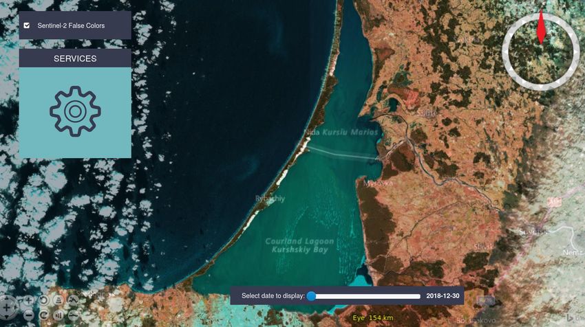
4 Big Data Toolbox Prototype
An initial prototype service has been established on GEOMATRIX-owned server with access to
Sentinel 1 and 2 data which has been pre-processed by SAGRIS. A demo website to showcase some of
the capabilities of the service has been implemented as well by rasdaman.
Figure 8 Big Data Toolbox demo entry page showcasing the WMS service on 3D time-series
Sentinel-2 data.
Figure 8 is a screenshot of the demo showing 3D WMS support, while Figure 9 shows the several
WCPS query examples on time-series Sentinel-2 data. The demos will be extended once the full
service is established on the DIAS platform.
Page 24 of 26D3.1 Big Data Toolbox I
Figure 9 Various examples of Sentinel-2 time-series data processing, fusion and summarization with
OGC WCPS queries.
Page 25 of 26D3.1 Big Data Toolbox I
Our Partners
Page 262020
This project has received funding from the European Union’s Horizon of 26
research and innovation programme under grant agreement No 824478.You can also read