Gippsland Region
Extreme Weather Event
      June 2021
←
→
Page content transcription
If your browser does not render page correctly, please read the page content below
Gippsland Region
Extreme Weather Event
June 2021
Our Values

    We pride        We are part of   Safety drives our   Focused and   Together we are
  ourselves on      our community       decisions         adaptable       VICSES
  our credibility

                                                                              2
Background
• Throughout the night of Wednesday 9th June 2021 and into the following day,
  Victoria experienced a severe weather event with strong winds and heavy rain
  which caused widespread damage, flooding and power outages.

• What would unfold would be the busiest 24 hours in the history of the Victoria
  State Emergency Service with over 9,000 RFAs in one week.

• An initial Flood Watch for Gippsland was issued on Tuesday 8th June with
  rainfall totals of 60-100mm expected across the flood watch area through
  Wednesday and Thursday, with up to 150-250 mm likely about the ranges. The
  focus of the heaviest rainfall would be across West and South Gippsland.

• The Bureau of Meteorology warned 19 catchments could be impacted with
  minor to moderate flooding expected across West Gippsland and the Mitchell
  River catchment from late Wednesday evening, with major flooding possible.

• A Severe Weather warning for damaging winds was issued on Wednesday 9th
  June for West and South Gippsland and parts of East Gippsland.

                                                                       3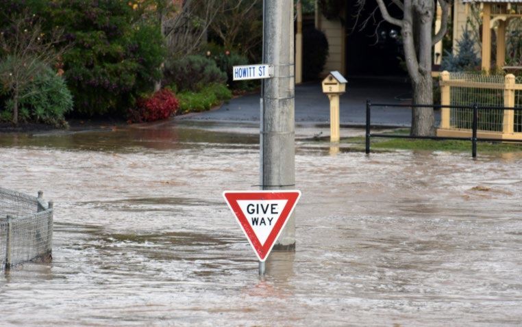
Background
• A Severe Weather warning for HEAVY RAINFALL was issued on Wednesday
  9th June for heavy rainfall developing about West Gippsland and Central
  Highlands.

• The East Coast Low would deliver heavy rain leading to flooding and damaging
  destructive winds and was expected to have multiple centres that would
  influence the location and timing of the heavy rain.

• 24 hour rainfall totals from late Wednesday morning to late Thursday morning
  were expected to be 70 to 120mm across the warning area, reaching 150 to
  250mm about higher terrain in West Gippsland.

• Catchments are already saturated across much of West and South Gippsland,
  and wet to moderately wet through East Gippsland.

                                                                      4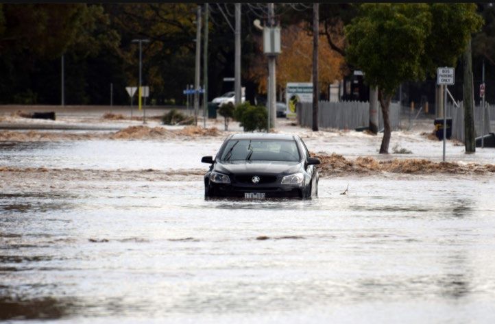
Background
• An initial Major Flood Warning for the Macalister River was issued by the BoM
  at 3:52 PM on Wednesday 9th June.

• An initial Major Flood Warning for the Thomson River was issued by the BoM at
  4:19 PM on Wednesday 9th June.

• An initial Major Flood Warning for the Avon River was issued by the BoM at
  4:27 PM on Wednesday 9th June.

• An initial Moderate Flood Warning for the Traralgon Creek was issued by the
  BoM at 4:43 PM on Wednesday 9th June.

• An initial Moderate Flood Warning for the Mitchell River was issued by the BoM
  at 5:43 PM on Wednesday 9th June.

• A Major Flood Warning for the Traralgon Creek was issued by the BoM at 1:59
  AM on Thursday 10th June.

                                                                       5
Background
• The Victorian government declared a state energy emergency after flooding
  caused cracking at Yallourn power station’s Morwell River Diversion wall.

• V-Line trains on the Gippsland line between Traralgon and Bairnsdale were
  suspended.

• An increased risk of beach erosion was present due to the unusual,
  perpendicular (south-east) wind direction, which would cause swells to impact
  Gippsland beaches.

                                                                      6
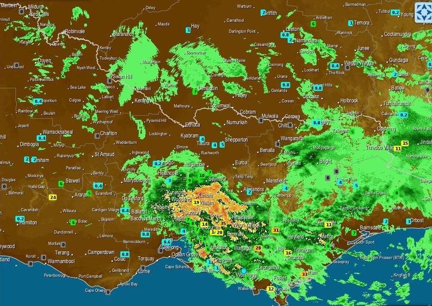
Daily rainfall totals for Victoria 10/6/21

                                     7
Rainfall magnitudes across the region
Location 9 June 10 June 11 June ARI AEP
Jindivick 3 71 2
2 to 5 50% to 20%
Darnum * 2.8 67 0.8
5 to 10 20% to 10%
Mt Baw Baw AWS * 1.6 280 17
>100 >1%
Nilma North (Warragul) * 3.6 47 1.8River flows across the region
Time of
River Gauge Date Peak Height FCL ARI
Avon Stratford 10-Jun 7:37pm 6.89 Major 13
Macalister Licola 10-Jun 1:04pm 4.2 Major 32
Aberfeldy Beardmore 10-Jun 1:06pm 6.17 40-50
Thomson Cooper Creek 10-Jun 11:42am 5.3 Major 28
U/s Cowwarr
Weir 10-Jun 12:03pm 7.6 Major 30
Wandocka 10-Jun 5:02pm 6.89 Major 8
Bundalaguah 11-Jun 3:08am 7.8 10
Sale wharf 11-Jun 9:22pm 3.45 Moderate
Tanjil Tanjil Junction 10-Jun 10:15am 5.72 Major 17
Tanjil South 10-Jun 10:00pm 3.15 Moderate >100
Latrobe Noojee 10-Jun 0:44am 3.82
Willow Grove 10-Jun 4:30pm 4.7 Minor >100
Thoms Bridge 11-Jun 2:00am 6.39 Moderate 12.5
Traralgon
Creek Traralgon 10-Jun 9:00am 5.76 Major 75
Moe Darnum 12-Jun 4:00pm 4 Minor 3
Morwell Boolarra 10-Jun 6:00am 5.1 Moderate 20-50
9Warnings issued
Warning Level Hazard Type Total
Advice Message - Flood Watch Flood 51
Advice Message - Minor Flood Warning Flood 101
Advice Message - Final Minor Flood Warning Flood 12
Warning - Moderate Flood Warning Flood 56
Warning - Major Flood Warning Flood 33
Warning - Severe Weather Storm 3
Emergency Warning - Major Flood Warning Flood 13
Evacuate Now Flood 16
All Clear - Final Flood Watch Flood 2
All Clear - Safe to Return Flood 2
Total Messages 289
Warnings issued from the 8th June 2021 to 14th June 2021
10Region Impacts
• Damage was widespread – impacting five of the region’s six LGA’s which
included 48 regional towns.
• A significant number of communities were isolated, some for several days.
• Access was cut to most roads and major highways by either flooding or trees
down which compounded the isolation of local communities.
• Widespread power and telecommunications outages (200K +).
• 552 stock losses (predominantly sheep) 4152 ha pasture/crop loss, 245 tonnes
lost, 356 km fences destroyed, infrastructure losses 52.
• Damage to roads and bridges through erosion, landslides and trees down.
• At start of the incident 196 road closures reported across RRV and LGAs.
11Region Impacts
• Parks and state forests closed across Gippsland (including Wilson's Prom
National Park).
• Storm damage (fallen trees, damaged road infrastructure and landslides)
affecting roads throughout Gippsland. Strzelecki Ranges, Great Alpine Rd,
Baw Baw Tourist Rd and Baw Baw NP (Mt St Gwinear Rd) and the state forest
around Thomson Dam.
• 258ha of windthrown plantation identified near Budgeree and isolated areas
between ¼ to 2 ha identified between Budgeree Rd and Hyland Hwy, along
Grand Ridge Rd.
• Residential properties impacted with above floor flooding
• Commercial properties impacted with above floor flooding
• Communities evacuated.
12Traralgon Community Impacts
Rapid rises in water levels in Traralgon
Creek caused widespread damage and
disruption, including:
• Many houses and businesses close to
Traralgon Creek were impacted from
over floor and yard flooding
• Many roads inundated
• Complete inundation of Traralgon
Recreation Reserve and tennis club
• Large parts of Victory Park and Bert
Thompson Reserve under water
Photos courtesy of Latrobe Valley Express
13Traralgon Community Impacts
• Mantra carpark flooded
• Traralgon Centre Plaza underground
carpark severely flooded
• Large areas of farmland inundated
• Many rescues performed from houses
and cars in flood affected areas
• Trees uprooted and debris/mud
everywhere
Photos courtesy of Latrobe Valley Express
14Response
• A total of 1,185 request for assistance (RFAs) were received from the 9th June
to 13th June 2021, of these:-
• 759 Trees down
• 94 Building damage
• 121 Flooding
• 57 Flood Rescues
• Multi agency response from VICSES, CFA, FRV, DELWP, VicPol, Local
Government Authorities, ADF, Life Saving Victoria, VicRoads and Ambulance
Victoria and other partner agencies.
• Taskforces, IMT staff, and resources from South West, Mid West, and Central
regions were deployed into the Gippsland Region ahead of the forecasted
flooding.
• The Bairnsdale and Traralgon Incident Control Centres operated 24/7.
15Response
• 17,363 SES Volunteer hours across the 5 days
• Extensive support from the business community and community members to
support volunteers and the Incident Control Centre.
• FFMV crews working from local management areas assessed impacts and
facilitated safe access and egress for communities and essential services.
• A road planning/operations cell was activated in the Traralgon ICC to manage
road recovery across Gippsland.
16You can also read