GIS Flipped ! Presented by Mark Miller, OCT and Andrea David Suzuki Secondary School, Brampton ON Luksts, OCT
←
→
Page content transcription
If your browser does not render page correctly, please read the page content below
GIS Flipped !
                        Presented by Mark Miller, OCT and Andrea
                                       Luksts, OCT
                       David Suzuki Secondary School, Brampton ON

Thursday, 17 October, 13
Introduction of
                                    Ourselves
                           Mark Miller -
                           Geography Teacher,
                           Outdoor enthusiast.
                           World Traveller.

                           Andrea Luksts -
                           Department Head of
                           Global Studies, Green
                           Leader at school and
                           board level

Thursday, 17 October, 13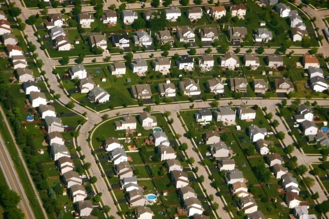
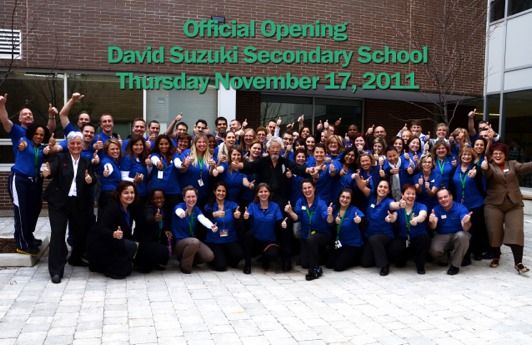
Opening the School
                 David Suzuki SS opened in
                 September of 2011, with a
                 vision that encompassed
                 sustainability, technology
                 and access to opportunities
                 for all.

                 School motto: BE THE
                 CHANGE

                 Located on the western
                 edge of Brampton in an area
                 under tremendous pressure
                 from suburban sprawl and
                 unchecked development.

Thursday, 17 October, 13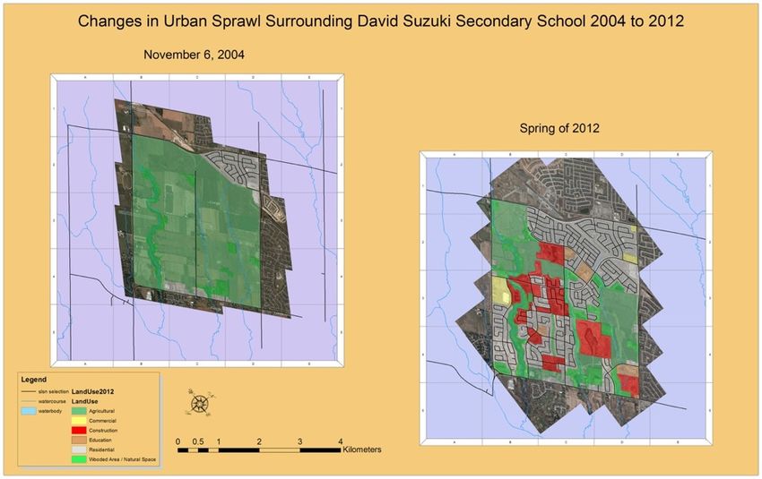
David Suzuki’s Mission to
                            Us
                      Dr. David Suzuki visited the
                      school in November of 2011
                      during our grand opening.

                      His key message to staff and
                      students “You are connected.
                      You are part of this community.
                      You must be stewards of the
                      surrounding natural area”

                      The geography program at DSSS
                      takes this message very
                      seriously and has made
                      Sustainability, TEK and
                      community connections an
                      essential part of the curriculum.

Thursday, 17 October, 13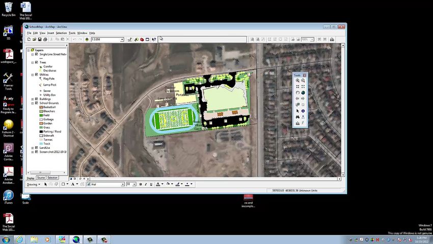
Flipped???
                      This year, the geography program has been
                      implementing “Flipped Lessons”

                      Flipping involves students learning short lessons
                      via video or self exploration at home, allowing the
                      classroom to be used as a time for reinforcement
                      via exploration, games, debates, discussions or in-
                      class tutorials.

                      Essentially, this “flips” the traditional classroom,
                      making the teacher the “Guide on the Side”
                      instead of the “Sage on the Stage”

Thursday, 17 October, 13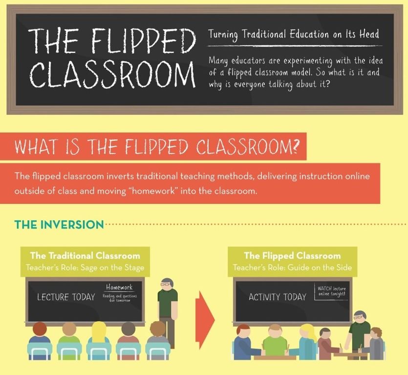
Thursday, 17 October, 13
Thursday, 17 October, 13
Thursday, 17 October, 13
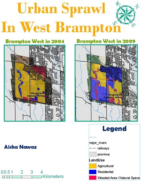
The Urban Sprawl
                                Lesson
                   A combination lesson of
                   research and GIS map
                   creation

                   Goal of understanding the
                   changes that have occured
                   directly around DSSS in the
                   last 8 years

                   Uses georeferenced aerial
                   photographs to look for
                   changes in land use

Thursday, 17 October, 13
Thursday, 17 October, 13
Thursday, 17 October, 13
Student Background
                               Knowledge
                           Students have created two maps prior in the
                           semester

                           Can load layers, adjust colours based on
                           attributes, create layouts for printing /
                           submission

                           Can verbally describe what is shown on map

Thursday, 17 October, 13
In class disccusions
Prior to lab periods
In Class discussions / flipped lesson
around urban growth / sprawl
Impacts on the environment and water
health due to human activities
Can identify what a watershed is and
which one we live in
Thursday, 17 October, 13Students Provided
With...
Aerial photos already georeferenced
Land use layer created
Arc Map structure created
Thursday, 17 October, 13Final Product
Map layout showing area in 2004 and 2012
2 page report about potential impacts of
development on the Credit River
Thursday, 17 October, 13Thursday, 17 October, 13
!!!!!!!!!!!!!!!!!!!!!!!!!!!!!!!!!!!!!!!!!!!!!!!!!!!!!!!!!!!!!!!!!!!!!!!!!!!!!!!!!!!!!!!!!!!!!!!!!!!!!!!!!!!!!!!!!!!!!By:!Aisha!Nawaz!

                           Urban&Sprawl&in&Brampton&West&
                                1. Write!a!paragraph!detailing!the!changes!in!land!use!over!the!five!year!period!between!
                                   the!two!maps.!

                           There!have!been!major!changes!in!Brampton!between!the!years!of!2004!and!
                           2009,!one!of!the!main!points!that!I!have!noticed!are!the!residential!areas!have!
                           had!a!major!growth.!And!as!Brampton`s!population!grew!they`ve!had!to!remove!a!
                           lot!of!the!surrounding!forest,!farms,!etc.!Most!of!the!residential!area!were!located!
                           near!our!three!rivers,!but!they!have!been!moved!farther!away!from!the!rivers!and!
                           closer!to!the!main!roads.!The!residential!rate!takes!up!about!60K70%!of!the!
                           Brampton!area.!Another!reason!being!the!agriculture!rates.!The!farming!rate!in!
                           2004!for!Brampton!was!much!larger!than!what!it!was!in!2009.!As!more!people!
                           moved!into!Brampton!they!had!to!remove!certain!areas;!one!being!the!farmland.!
                           Ever!since!2004!the!farming!rate!has!dropped!about!50%!in!this!small!area.!And!as!
                           the!population!keeps!growing!they!have!to!remove!one!or!another!area;!in!this!
                           situation!being!the!farm!land.!Lastly!being!all!the!natural!space.!As!Brampton!
                           West!has!had!a!major!growth!they`ve!had!to!remove,!replant!and!add!a!lot!of!new!
                           trees!or!plants!to!the!area.!And!make!space!for!our!future!home,!schools,!etc.!I!
                           can!tell!that!the!“forest!areas”!(natural!spaces)!aren’t!in!the!same!space!as!they!
                           use!to!be.!Most!of!them!have!been!removed!and/or!replanted!in!a!different!area.!
                           Most!of!the!natural!spaces!in!2004!were!in!the!topper!right!corner!but!as!time!
                           passed!(2009)!they!were!moved!closer!to!the!rivers.!I!would!say!that!about!20%!of!
                           natural!areas!make!up!our!city.!!
                                2. Research!the!possible!impacts!on!rivers!due!to!urban!stresses.!Suggest!possible!
                                   environmental!problems!for!the!three!tributaries!of!the!Credit!River.!Write!a!one!page!
                                   report!detailing!your!research!and!suggestions!that!we!should!follow!to!minimize!our!
                                   impact!on!these!creeks!as!residents!of!the!area.!

                           The!possible!impacts!on!the!river!due!to!urban!stress!could!be!because!the!
                           population!that!is!constantly!increasing!and!as!they!make!new!homes,!schools,!
                           stores,!etc.!They!move!closer!and!closer!to!the!river!impacting!the!animals!that!
                           contribute!to!the!river!and!cause!slight!to!large!amounts!of!damage.!Another!
                           reason!for!the!urban!stress!on!the!rivers!could!be!all!the!trash!that!has!been!left!

Thursday, 17 October, 13
What the Kids Get out
of this??
Comfort using GIS / building on skills and
pride in accomplishment
How is GIS a useful tool outside of
Geography Class
An understanding that development impacts
watershed quality and general quality of life
for humans and wildlife
Connection of ownership and responsibility
for the local area / community
Thursday, 17 October, 13Areas to build on
Constant need to update data as the area
develops
More time needed for research skills for
report
Competition for tech within the school
Thursday, 17 October, 13Local Area Data for your
School
Pictures from Google Earth
Open Source Data - i.e.Open Source Toronto
ESRI Website
Thursday, 17 October, 13Teacher Prep
Georeferencing Pics
Editing / Creating Land Use Layer (Arc 10x)
Download lab instructions here
Thursday, 17 October, 13The Future
Mobile GIS applications - When Tech level
grows
Having students monitor health of local area
(School and off property) with live data
collection
Thursday, 17 October, 13Questions
?
Thursday, 17 October, 13Contacts
Youtube Channel - Geography Flipped
Classroom
Twitter @ms_luksy @mark70410
Thursday, 17 October, 13You can also read