GOLD RUSH SNOWMOBILE TRAIL 70 MILE HOUSE TO HORSEFLY - District of 100 Mile House
←
→
Page content transcription
If your browser does not render page correctly, please read the page content below
GOLD RUSH SNOWMOBILE TRAIL

                     70 MILE HOUSE TO HORSEFLY

             Encouraging Tourism Sector Product & Business Development
                          in the Cariboo-Chilcotin

                                      Prepared for

                     The District Municipality of 100 Mile House

                                      Prepared by:

                               Steve Law, R.P.F.
                           DWB Consulting Services Ltd.

2010/06/01                 Gold Rush Snowmobile Trail              Page 1 of 30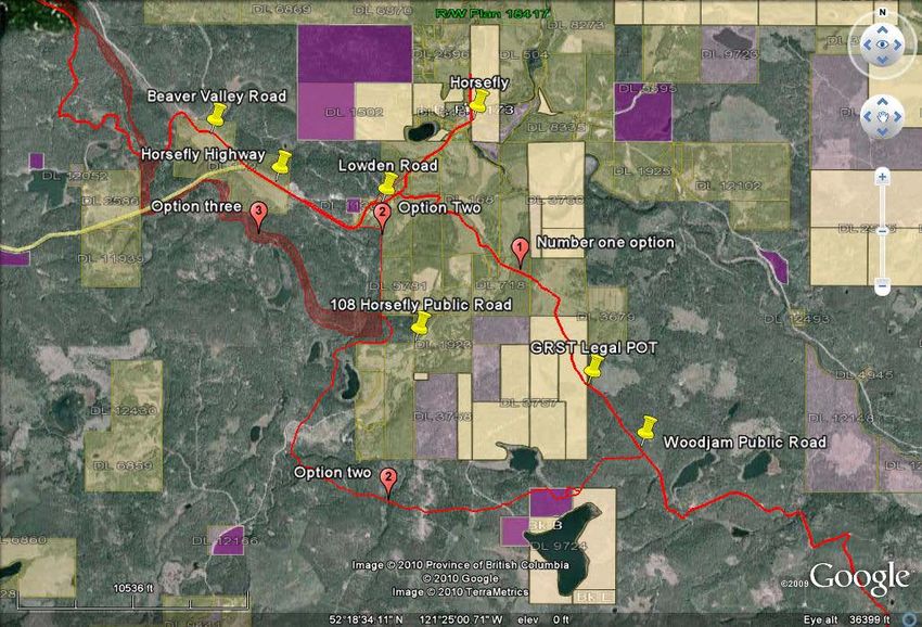
ACKNOWLEDGEMENTS

This project has been made possible thanks to the funding provided by Western Economic
Diversification, Northern Development Initiative Trust, District of 100 Mile House and the
Ministry of Tourism, Culture and the Arts.

The idea of the Gold Rush Snowmobile Trail has been around for many years and was the brain
child of Jack Barnett, a long time resident of 100 Mile House and one of the original members of
the 100 Mile House Snowmobile Club. We would like to thank Jack for providing invaluable
knowledge and background on the trail.

The Ministry of Tourism, Culture and the Arts (MOTCA) was instrumental in providing approvals,
background information, digital files and valuable field time to assess the trail. We would like to
thank Doug Harris (MOTCA - 100 Mile House) and Desi Cheverie (MOTCA – Williams Lake) for
their invaluable assistance.

The local snowmobile clubs also took time to meet with us and supply not only information but
important suggestions and ideas to help in all facets of trail location, signage, maintenance and
incorporation with other trails.

Lastly, we would like to thank Joanne Doddridge, the District Planner and Roy Scott, the District
Administrator who provided guidance and direction. Their suggestions and recommendations along
the way were appreciated.

2010/06/01                        Gold Rush Snowmobile Trail                    Page 2 of 30
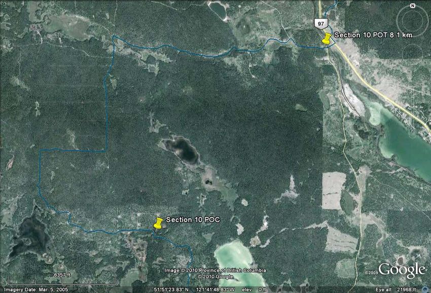
Table of Contents
1.0 Executive Summary ........................................................................................ 4

1.1 Trail Cleanup................................................................................................... 5
1.2 Trail Cleanup Sections……………………………………………………………..7

2 Scott Creek Bridge Replacement……………………………………………………9
3. Signage ......................................................................................................... ..10
3.1 Existing Signage……………………………………………………………………10

3.2 New Signage……………………………………………………………………….11
4. Brochures and Distribution .............................................................................. 13
4.1 Brochure Distribution List…………………………………………………………14
6. Master Trails Map ........................................................................................... 15

7. Horsefly to Likely Extension ............................................................................ 15

8. Marketing and Communications...................................................................... 19
8.1 Websites…………………………………………………………………………....20

8.2 Trail Maintenance………………………………………………………………….21
9. Integration Plan ............................................................................................... 23

10. Key Recommendations ................................................................................. 27

Appendix I: GRST Brochure................................................................................ 28

Appendix II: Master Trails Map ........................................................................... 29
Appendix III: Literature Cited………………………………………………………….30

2010/06/01                                    Gold Rush Snowmobile Trail                                     Page 3 of 30
1.0 Executive Summary
    Funding for this project was initially applied for in 2007 through Western economic
    Diversification and Northern Development Initiative Trust. In kind contribution and dollars was
    provided through the District of 100 Mile House and the Ministry of Tourism, Culture and the
    Arts.

    The concept of the Gold Rush Trail has been around for many years. The original intent saw a
    trail which linked communities from Clinton in the south all the way to Barkerville in the north.
    The trail would provide a reason for tourists to come to the area and travel the route making
    stops in the communities along the way. For the purposes of this project the focus is on the trail
    from 70 Mile House in the south to Horsefly, in the north.

    The District put out proposals on June 30, 2009 to be received by July 22, 2009 with the intent of
    hiring a project manager to carry out and oversee the project delivery. The project deliverables
    were as follows:
    ● clean-up approximately 50km of the existing trail,
    ● construction of bridge at Scott Creek
    ● identify, design and install signage along the route,
    ● design, print and distribute brochures,
    ● produce a Master Trails Map(s),
    ● ensure the Horsefly to Likely extension of the trail is incorporated,
    ● produce a marketing and communications plan,
    ● produce an integration plan.

    It should be noted that New Pathways to Gold Society (NPTGS) had also been in discussion with
    the District as they were also interested in contributing significant dollars to the clean up portion
    of the trail. NPTGS in partnership with the District also retained DWB to jointly look after their
    contribution to the trails. The sections worked on and contractors hired were kept completely
    separate.

    DWB Consulting Services Ltd. was the successful proponent and started work on the trail in late
    August. The project was tendered to a select list of contractors and an average day rate was
    established. Contractors started in October and worked through on the District project until mid
    January 2010.

    The three-person crews consisted of local contractors as well as First Nations crews from
    Canoe/Dog Creek, Canim Lake and Alkali Bands.

    The Scott Creek snowmobile bridge was constructed and installed by Sitka Log Homes of 100
    Mile House in early December.

    Local snowmobile clubs were contacted and meetings held to discuss the route, signage and
    other issues related to the GRST. The few resorts and facilities along the route were also
    consulted to explore access and linkage to the trail as well as any marketing opportunities.

2010/06/01                         Gold Rush Snowmobile Trail                       Page 4 of 30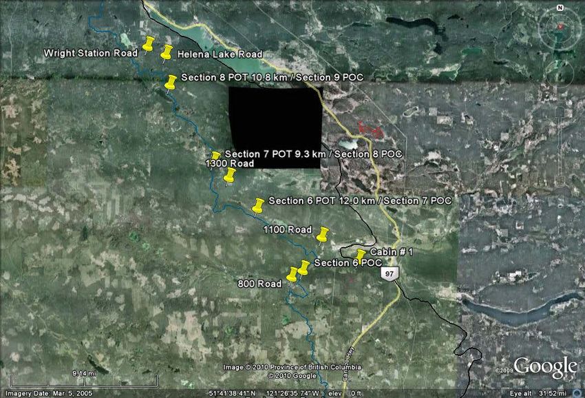
Consultation also occurred regularly with the representatives of the Ministry of Tourism, Culture
         and the Arts as well as with the Ministry of Transportation and Infrastructure.

         Throughout the course of the trail clean up activities and route evaluation, signage design,
         location and distribution was considered. Signage was designed and installed based on the
         considerations.

         Lastly the development of trail brochures occurred with consultation with representatives of the
         District, Ministry of Tourism, Culture and the Arts, South Cariboo Tourism Infocentre and the
         British Columbia Snowmobile Federation.

     1.1 Trail Cleanup
1.
         Upon the awarding of the contract in late August of 2009, work immediately commenced on the
         tendering and contractual agreements required in the selection and hiring process of 3-person
         falling, bucking and burning crews. Seven experienced and reputable contractors were asked to
         submit an all inclusive day rate bid for a three person crew to carry out the prescribed work on
         the Gold Rush Snowmobile Trail. Once the bids were received, an average of the bids was
         obtained. The contractors were then approached to confirm their willingness to carry out the
         clean-up work using the average bid. Upon acceptance of the rate crews were put to work, as
         they became available. Sections of the trail were assessed and prioritized by elevation, access
         and location, etc; Crews were then distributed accordingly. The first crew commenced work on
         November 1, 2009.

         Additional funding was provided by National Trails Coalition and New Pathways to Gold
         Society for trail cleanup only. The funding, crews and sections worked on were kept separate
         from this project. The funding for this project had budgeted for the cleanup of approximately
         50km of trails. With the additional funding from New Pathways and National Trails Coalition
         approximately 150km of trail cleanup was carried out. The entire trail from 70 Mile House
         through to the Williams Lake Forest District was treated and made passable.

         The cleanup consisted of falling, mainly dead pine, within 5m of the trails edge on both sides of
         the trail. The tops and limbs were then piled and burned. Any pine snags, outside this zone, with
         a significant lean towards the trail were also felled. Any trees live or dead impeding the
         trafficability of the trail were also removed (see figures 1-3).

     2010/06/01                        Gold Rush Snowmobile Trail                    Page 5 of 30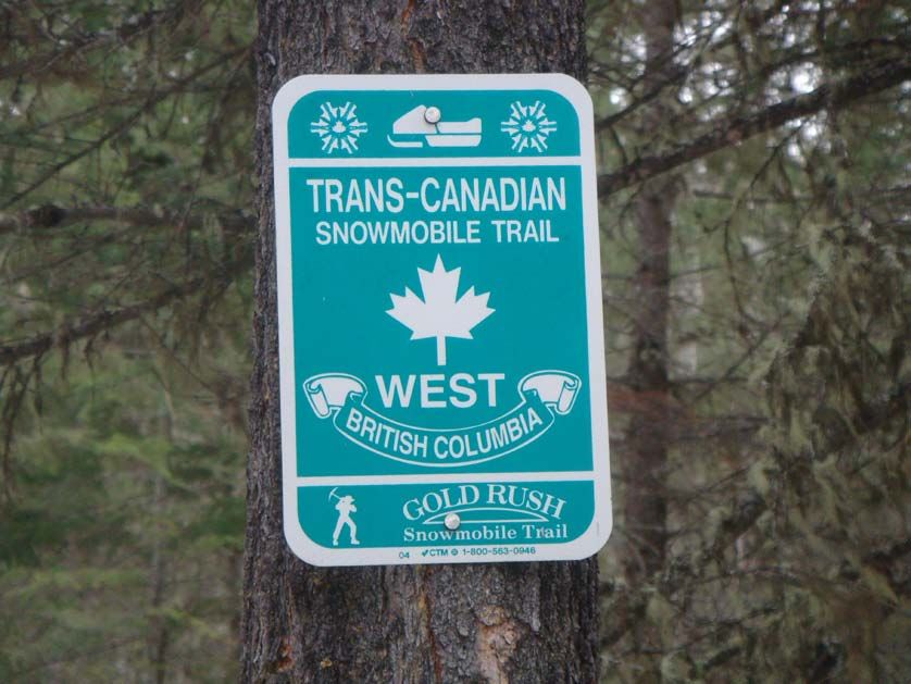
Figure 1

                              Figure 2

2010/06/01   Gold Rush Snowmobile Trail   Page 6 of 30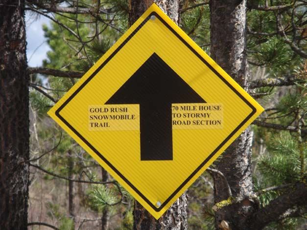
Figure 3
The trail cleanup ranged from falling a few trees along the trail to almost re-establishing the trail.
Construction of new trail or machine work on the existing trail was not part of the mandate of
this project.
1.2 Trail Cleanup Sections
Trail sections were assessed prior to starting treatment. The treatment area was limited to within
the 100 Mile House Forest District. Sections were assessed first for their need for treatment, i.e.:
logged or immature areas required little to no treatment. Access and elevation were considered in
prioritizing treatment areas given the potential onset of winter conditions. High elevation areas
and areas with poor access were started in late fall.
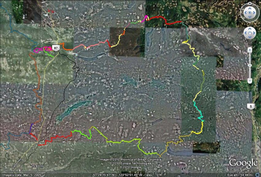
The attached Google Earth images outline the sections treated using the funding for this project
(figures 4, 5). It should be noted that the remaining sections of the trail from 70 Mile House
through to the 100 Mile Forest District boundary and beyond were also treated but through
funding provided by New Pathways to Gold Society so they are not reported as part of this
project.
2010/06/01 Gold Rush Snowmobile Trail Page 7 of 30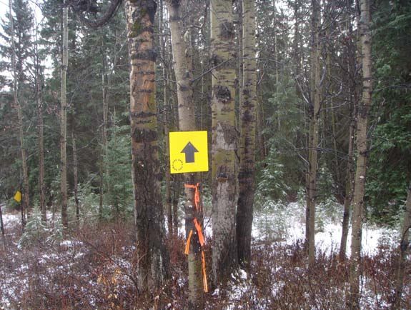
Figure 4 – 1100 Road to Helena Lake Section

             Figure 5 – 700 Road to Wright Station Road Section

2010/06/01              Gold Rush Snowmobile Trail            Page 8 of 30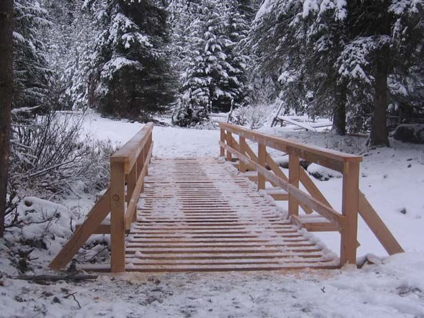
2. Scott Creek Bridge Replacement

    One of the main activities identified in this project was the replacement of an old snowmobile
    bridge at Scott Creek. This crossing is located north of Lac La Hache at the 122 Mile. The old
    log structure bridge had been broken and had fallen into the creek (figure 6).

                                 Figure 6 – Old Scott Creek Bridge

    A 10 meter snowmobile bridge (fig. 7) was constructed and installed by Sitka Log Homes of 100
    Mile House. The bridge was based on an engineered design from a similar crossing with the
    same span. The bridge was installed in December of 2009.

2010/06/01                       Gold Rush Snowmobile Trail                   Page 9 of 30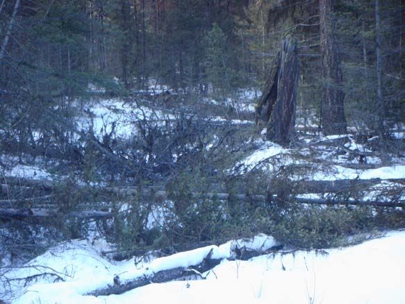
Figure 7 - Scott Creek Bridge

3. Signage

    Signage was developed after consultation with the local snowmobile clubs, Ministry of
    Highways, Ministry of Tourism, Culture and the Arts and in consideration of the British
    Columbia Snowmobile Federation “Standards for Snowmobile Trail Signing & Placement in
    British Columbia”.

3.1 Existing Signage

    The signage prior to the inception of this project was primarily limited to directional signage (see
    fig. 8) on the trails and Highways standards signs such as stop signs and snowmobile crossings
    where the GRST crossed public roads (see fig. 9).

    As per the signage standards the purpose of snowmobile trails signs are to:
    a. regulate the flow of traffic along trails
    b. inform riders of trail characteristics and,
    c. provide information necessary to the enjoyment of the trails

    Properly installed signs will not only enhance the safety and security of persons using the trail,
    improve travel within and between districts and professionalize and promote recreational
    snowmobiling.

2010/06/01                         Gold Rush Snowmobile Trail                     Page 10 of 30
Figure 8 – Snowmobile Directional Sign
Figure 9
3.2 New Signage
To be consistent with the previous directional signage the “Gold Rush Snowmobile Trail” was
also put on the directional signs as well as the trail section location, ie: 70 Mile House to Stormy
Road Section (see fig. 10). This allowed trail users an indication of their approximate location
when in between the map/junction signs (see fig. 11). This also prevents confusion when
entering onto the trail from a connector trail or any other route which may cross the GRST.
2010/06/01 Gold Rush Snowmobile Trail Page 11 of 30Figure 10
Map signs were installed at most major crossings and at all designated trail head locations. These
signs consisted of a large scale map of the GRST showing the users location at a junction of the
GRST and a public road. The corresponding road section and their distances were also put on the
trail map sign.
Figure 11
2010/06/01 Gold Rush Snowmobile Trail Page 12 of 30Four larger map signs were made up specifically for trailhead locations and/or locations which
have the most traffic and potential visibility. These are the 70 Mile House Trailhead, the 100
Mile House Snowmobile Club Parking area, the Helena Lake Recreation site and at Ten-eeh-ah
Lodge on Spout Lake. As these areas will undoubtedly be both trailhead areas and will receive
the most public visitors, they were deemed the most appropriate locations to promote awareness
of the trail.
The ten small map signs were placed from 70 Mile House to the 100 Mile House Forest District
Boundary where the GRST crossed public roads. Again the site locations were chosen not only
to inform users of their location but in visible public travelled areas to promote awareness of the
GRST. The site locations are as follows:
100 Mile House South
Green Lake Snowmobile Club Parking Area
Stormy Road
Davis Lake Road
Bullock Lake Road
1100 Road
100 Mile House North
1300 Road
Wright Station Road
Woodfrog Public Road
Kokanee Pit Road
1500 Road
4. Brochures and Distribution
A key component of promotion and marketing of the GRST was the development, design and
distribution of trail brochures. A brochure was developed targeting the snowmobile demographic
and containing information specific to the location, use, communities and amenities along the
GRST. Linkages were also provided to the local clubs who are responsible for maintaining the
trail and would have current knowledge as to its condition.
A copy of the GRST brochure is included in Appendix I.
The racking and distribution of brochures is critical in the promotion of the trail. The target
demographic (including locally) for the GRST will be mainly snowmobile retailers in the Lower
Mainland, Okanagan and Alberta. The following brochure distribution list outlines the areas,
clubs and agencies considered for distribution. Additional brochures will be held by the District
to supply existing distributors, upcoming events such as trade shows and for regional, provincial
and out of province distribution.
2010/06/01 Gold Rush Snowmobile Trail Page 13 of 30Brochure Distribution List
Location # of Brochures
100 Mile House
Tourism Info Centre 200
Ministry of Tourism, Culture and the Arts 200
South Cariboo Motor Sports 200
Cariboo Supply and Marine 200
Exeter Supply and Marine 200
Performance All Terrain & Rental Ltd. 200
100 Mile District 1200
Green Lake Snowmobile Club 200
100 Mile Snowmobile Club 200
Interlakes Snowmobile Club 200
70 Mile Motel 200
South Cariboo Recreation Centre 200
Ten-eeh-ah Lodge 200
Hills Health Ranch 200
Williams Lake
Tourism Info Centre 200
Ministry of Tourism, Culture and the Arts 300
Williams Lake Powder Kings 200
Spectra Power Sports 200
Williams Lake Recreation Sales and Service 200
Gordo’s Rent-All 200
Cariboo Memorial Recreation Complex 200
Horsefly 200
Likely 200
Kamloops
Ministry of Tourism, Culture and the Arts 300
Kamloops Snowmobile Association* 600
*includes distribution to local retailers
Lower Mainland (retailers) 1400
Okanagan (retailers) 1000
Alberta (retailers) 1000
2010/06/01 Gold Rush Snowmobile Trail Page 14 of 306. Master Trails Map
A master trails map was completed from information collected from various clubs and
organizations with the main source of trails from the Ministry of Tourism, Culture and the Arts
(MOTCA). Other sources were a combination of digital, GPS, paper maps and ortho photos.
The intent of the master trails map is a colation of all existing known trails both registered and
non-registered. This map is not intended for navigational purposes, but more of long-term
tracking and record keeping tool.
Maps of the individual trails can be obtained for the various areas from the organizations or clubs
responsible for the trails, such as the Green Lake Snowmobile Club, 100 Mile Nordic Ski
Society, Ministry of Tourism, Culture and the Arts.
The Master Trails Map(s) are located in Appendix II.
7. Horsefly to Likely Extension
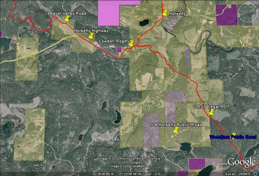
The current legal point of termination (POT) for the Gold Rush Snowmobile Trail is located in
the Central Cariboo Forest District at the junction of the Woodjam Public Road and the 108
Horsefly Public Road at the south boundary of District Lot 3759 (Figure 10).
As indicated in the Gold Rush Snowmobile Trail Pilot Project (February 14, 2002) the use of the
public road is a viable option because of the large tracts of private land surrounding the
community of Horsefly. However, options for travel along these sections of public road are
limited to the road shoulder as these roads are classified as Section 4 with no provided adjacent
right of way through deeded lands.
2010/06/01 Gold Rush Snowmobile Trail Page 15 of 30Fig. 10 - GRST Legal Point of Termination
The issues associated with snowmobiling on public roads remain the same as identified in the
previous Gold Rush Snowmobile Trail – Pilot Project. The public roads are well-maintained,
including ploughing and sanding. Snowmobiling along these roads would be limited to the road
shoulder which is not always a suitable running surface for snowmobiles. Another major
consideration in using maintained public roads is snow levels. Snow cannot be well managed or
protected in these situations and in a low snow level year these routes may not be passable by
snowmobile. Lastly and most importantly, is safety. While the level of use on these public roads
in small, isolated communities such as Horsefly is considered low a safer and more viable option
(if available) would be the exploration of an alternative route.
In consideration of these complex issues, it was felt other options needed to be identified. As a
result, long-time Horsefly residents were consulted who are familiar not only with the original
proposed route but have considered and are aware of other potentially viable options.
These options would have to include both the entrance of Horsefly from the south and exiting
Horsefly en route to Likely to the north to also eliminate the use of Beaver Valley Public Road.
2010/06/01 Gold Rush Snowmobile Trail Page 16 of 30Based on these meetings a total of three options were identified:
Horsefly South
1. Stay with the original proposed route through Woodjam Public, 108 Public, Lowden Road
and the Horsefly Highway.
2. Talk to the private property land owners and propose a route along the edge of the deeded
properties.
3. Re-alignment of the Gold Rush Snowmobile Trail starting just prior to the current legal point
of termination on the Woodjam Public Road and proceeding west and then north along the
deeded land ad crossing the Horsefly Highway in a different location.
These three options are outlined in figure 11.
Figure 11 – Horsefly Private Land & Public Road Bypass
Horsefly North
1. Stay with the original proposed route along the Horsefly Highway, Beaver Valley Public
Road and permitted road through Woodlot 509.
2. Bypass the public roads and private land and cross the Highway on the west side of Lowden
road. Then proceed on the north side of the Horsefly highway and up the Beaver Valley Road
as in the original route.
2010/06/01 Gold Rush Snowmobile Trail Page 17 of 303. Bypass the public roads and private land and cross the Horsefly highway by DL3586
eliminating the use of all public roads (including Beaver Valley Road) and avoiding all
private property.
Likely South
Only one opportunity exists for access into and through the community of Likely. The Likely
Bridge is located on the west side of Likely and provides a public highway crossing across the
Quesnel River. As detailed in the “Pilot Project” the Likely bridge is identified as a section of the
route because of its importance to the overall trail alignment.
This opportunity remains the only viable option and is as follows:
Option 1
Utilize the Likely Highway and the Likely Bridge as access into the community.
If the route is to enter Likely and proceed beyond to Wells Barkerville, snowmobile traffic must
be permitted to cross the bridge.
The surface of the bridge is not a suitable running surface for snowmobiles and is of course
ploughed and well maintained through the winter snowmobile season. As discussed previously
the bridge could be retrofitted for a snowmobile lane. The cost associated with this would be
substantial.
Likely North
The route north of Likely was outside of the mandate of this project so will not be dealt with in
this report.
Recommendations
The issues surrounding snowmobiling on and along public roads and Highways are complex.
Current government policy and legislation prohibits the operations of snowmobiles on public
roads and their right of ways. New legislation dealing with outdoor recreation vehicles (ORV) is
currently proposed and may resolve this controversial and complicated issue. This legislation is
proposed to be in place by 2011.
The two new options presented above will require further exploration. If indeed viable, they will
require full consultation and referral. They were discussed jointly with the Ministry of Tourism,
Culture and the Arts and the Horsefly residents and will be field assessed this summer.
2010/06/01 Gold Rush Snowmobile Trail Page 18 of 308. Marketing and Communications
The intent of this project in terms of a marketing component was to identify market opportunities
in partnership with various communities along the GRST and explore tourism websites for wider
marketing of the trail system. This also included the production and distribution of brochures
and the coordination, the identification, design and installation of signage to promote the trail.
The following outlines a general marketing strategy considering the demographics, distribution,
web linkages, signage and post project strategy to ensure promotion of the GRST:
Target Demographic
- local outdoor clubs including snowmobiling, biking , hiking, horseback riding
- average age bracket for outdoor activities is 30-62 years old
- main outside area markets would be the Okanagan, Lower Mainland and Alberta
Media – Outdoor
- Billboard – Regional
- Trail and trailhead signage
Clubs
- notification to all Clubs that the trail exists and are usable
- they in turn can pass information onto sister clubs in outside areas
- provide maps and brochures to clubs
- integration/incorporation of other trail systems
Media - Web
- people coming in to the area look online for a link to their particular activity
- 108 Hills Health Ranch, TEN-EE-AH Lodge, etc;
- Provide resorts with info, web linkages, connecting trails to GRST
- Show benefits to using their existing resources to market the trail
- Develop Gold Rush Trail Website/Content Management
- Tourism BC
- South Cariboo Tourism website
Media – Print
- Brochure Production
- Rack in local tourism info-centres
- Airport Racking
- Rack brochures in outdoor retail stores
- Annual Outdoor Magazines (hiking, snowmobiling, general)
- Newspapers; i.e.: the Vancouver sun features a BC destination/activity weekly
- Tourism Visitors Guide
2010/06/01 Gold Rush Snowmobile Trail Page 19 of 30Collateral
- Resorts – provide them with website linkage, maps and brochures of trail (co-linking and
promotion)
- Tradeshows
- Video (there is an existing video)
Multi-use Trail
- important to advertise and promote trail as multi-season, multi-use not just for snowmobiling
and winter
- brochures mention that trail is suitable for biking, hiking and horse back riding
Maintenance
- in order to promote the trail there must be funding to ensure its continued maintenance
- trail and signage must be maintained as well as updating Master Trails Map(s) and any
brochures
- trailheads must be identified and constructed
8.1 Websites
A number of websites and potential linkages to websites were explored in consideration of
marketing of the GRST.
A new website that was re-developed and readily available was through the South Cariboo
Tourism Info- Centre. The GRST is mentioned under winter activities and a pdf of the brochure
will be available in the coming months. The South Cariboo Tourism website is:
www.southcaribootourism.ca
The Ministry of Tourism, Culture and the Arts (MOTCA) is the agency responsible for the
management of recreational trails in the province. To obtain information on the GRST, such as a
map, driving directions, listing of partners who co-manage (snowmobile clubs) go to the
following website and follow the linkages: www.sitesandtrailsbc.ca
Through contacts such as British Columbia Snowmobile Federation, Cariboo-Chilcotin Tourism
Association other potential websites to market and promote the trail were found. They are listed
below and while linkages to these sites did not get established, they are listed for their potential
in any subsequent marketing strategy.
www.letsridebc.com
www.hellobc.com
www.bcsf.org
2010/06/01 Gold Rush Snowmobile Trail Page 20 of 30The other websites explored were the existing snowmobile club websites which are all listed on
the brochure. Further discussions will be held with the clubs regarding the use of their websites
to provide linkage or promotional information relating to the GRST. The snowmobile club
websites are as follows:
www.greenlakesnowmobileclub.ca
www.100milesnowmobileclub.com
www.wlpowderkings.com
Other discussions were held with the manager of Ten-eeh-ah Lodge and Pat Corbett of the Hills
Health & Guest Ranch regarding the promotion and marketing of the trail. The trail runs through
Ten-eeh-ah Lodge and the Hills Health Ranch is a very well known tourist destination. Both
parties were excited and open to any ideas to promote the trail and resulting economic benefit to
the communities and businesses. Brochures have been distributed to the Hills and to Ten-eeh-ah
Lodge.
8.2 Trail Maintenance
Trail maintenance in British Columbia is done largely through the efforts of volunteers. As
volunteers grow older, trail systems become larger and club memberships decline, this becomes
a virtually impossible task. The mountain pine beetle epidemic has left much of BC’s pine stands
either dead or dying and continually decaying to the point of falling or blowing down. This has
made the task of maintaining the trails through these stands a daunting one.
User pay is the principle for operation of snowmobile trail systems in North America. Typically,
touring snowmobilers are looking for smooth, well-groomed and signed trails which can be
navigated by themselves with confidence and safety.
The following options for maintenance have been identified for consideration. The maintenance
of the GRST could be a combination of a few or all of the listed options depending not only on
the outcome of the ORV legislation, but the future population of users and the clubs who use and
maintain the trail.
Outdoor Recreational Vehicle (ORV) Legislation
British Columbia is in the process of developing legislation for the regulation of outdoor
recreational vehicles. All other provinces have this legislation. Once in place, all snowmobiles
and atvs will be required to be licensed and insured. In other provinces the monies generated
from this go back into trail maintenance. It has yet to be confirmed if the legislation will enable
this very important potential aspect of funding.
Memberships and Trail Permits
The local snowmobile clubs have very small numbers, so the dollars are insignificant. The
limited amount of funds collected go back into the running of the clubs.
2010/06/01 Gold Rush Snowmobile Trail Page 21 of 30Funding for public snowmobile trail systems which are paid by the snowmobile user include:
● snowmobile registration fees;
● snowmobile gas tax rebates;
● trail permits;
● volunteer trail construction and maintenance;
● snowmobile user permits.
Note: not all options in place in BC.
Grant-in-aid Programs
Many snowmobile trail systems have been developed through programs called grant-in-aid
programs. They allow a province to use funds to develop and maintain trails not only on
provincial or public owned lands but on private land and land owned by local governments, thus
making possible the development of a comprehensive, interconnecting system.
Under these grant-in-aid programs, snowmobile funds can be distributed to local governments or
recognized snowmobile clubs. Funds may be provided on a cost-sharing basis or they may allow
for 100% funding up to a maximum limit.
Multi-Use Trails
Trails developed with snowmobile funds directly benefit other outdoor recreational activities.
During the non-winter months, many of these trails are used for hiking, horseback riding,
bicycling and other trail-based activities.
Many areas have been effective in developing a shared financial responsibility for trails with
other user groups, benefiting business partners and tourism organizations.
Valemount Area Recreation Development Association (VARDA)
Valemount has been very successful in developing a sustainable trail maintenance program.
Through the use of monitored parking areas, trail ticket sales are collected at $15.00 per
person/day. There are on average approximately 13,000 passes sold per year, which amounts to
$195,000 in revenue collected. It should be noted that these trailhead areas are access to
mountain sledding not the type of sledding proposed on the GRST.
Funds are also raised through sponsorship with local businesses by offering marketing
opportunities. VARDA does not own grooming equipment. The grooming is contracted out with
an average cost (fuel cost dependant) of $21.00/km.
2010/06/01 Gold Rush Snowmobile Trail Page 22 of 309. Integration Plan
The Gold Rush Snowmobile Trail (GRST) Integration Plan has been written to identify, map and
consider the network of trails that link and or provide access to the GRST. Also to identify the
linkages or access to any Lodges, Resorts and business along the route. Only the trails within the
100 Mile House District are being considered for this plan. There are no known trails accessing
or crossing the GRST from the 100 Mile House Forest District boundary to Horsefly. There are
also no lodges resorts or services of any kind. The GRST from Horsefly onwards is still yet to be
defined legally, so that portion of the trail is not being considered in this plan.
The Gold Rush Trail starts in 70 Mile House on the west side of Highway 97 on Raphael Road.
Raphael Road is located just south of the 70 Mile House Motel. The east side of the highway,
until recently, had a store and gas station. The store burned down during the course of this
project and is scheduled to be rebuilt. Other amenities within walking distance include the Dusty
Rose pub/restaurant.
70 Mile House Trailhead
The available parking at the trailhead in 70 Mile House is limited largely to the discretion of the
private land owners. Parking was discussed with a few of the landowners and while they were
certainly agreeable because of the potential economic benefit there are no written agreements.
Because of this there is a recommendation for further parking to be explored.
Green Lake Snowmobile Trails
The only trails in the vicinity of the trailhead are the Green Lake Snowmobile Trails. These trails
can be accessed from the opposite side of the highway from the trailhead. The club has utilized
this section of trail in the past and the highways crossing, but has done so with permission from
the Clinton RCMP (see fig.). There are three applications which must me made prior to
accessing the trail head at 70 Mile House from the east side of the road:
1. An application is required for a highway crossing to be submitted to the Ministry of
Transportation and Infrastructure.
2. The trail is also on the old Cariboo Highway which will also require an application for
permission to operate snowmobiles within the highway right of way.
3. The old Cariboo Highway crosses the railway. This is a public crossing which is maintained
by CN Railway. An application must be made to CN to cross the tracks at this location and to
occupy their right of way.
Clinton
The original pilot project looked at the Gold Rush Snowmobile Trail starting in the village of
Clinton. While outside the mandate of this report it is recommended that the Clinton to 70 Mile
2010/06/01 Gold Rush Snowmobile Trail Page 23 of 30House section of the trail be revisited in the future. The connectivity to Clinton is important not
only for the economic development potential but for continuity of the recreation corridor.
Access to the trail through existing public roads is being mentioned for future development
purposes, such as access, parking and infrastructure development.
100 Mile House
Current access from 100 Mile House is limited to a connector trail which starts at the 100 Mile
House snowmobile clubhouse located at 99 Mile via Ainsworth Road. Access into 100 Mile
House is dependant via the 99 Mile connector trail which crosses the railway (permitted) through
district lot 4847 and 2139 which are privately owned. There are provisions to ensure the trail is
considered in the development of these lands with the intent of connecting to the Tourism Info
Centre. This was identified in the Trails Linkage Plan and is a key component to that plan and
key to the GRST in accessing all the services and amenities that 100 Mile House has to offer.
(The Trails Linkage Plan was developed in 2009 to identify a unified network of existing and
proposed trails providing a comprehensive trail system throughout the municipality of 100 Mile
House).
108 Mile Ranch
There are no known or existing trails linking the 108 to the GRST. A connector trail linking 100
Mile House to the Ranch was proposed under the Trails Linkage Plan.
The Hills Health and Guest Ranch is considered a major tourist destination in the province. The
Hills does offer some snowmobile touring in and around the guest ranch. The owner of the guest
ranch was consulted and was particularly interested in the marketing component of the GRST.
The guest ranch is very active and connected to Tourism BC and will be consulted in the
development of a marketing strategy for the trail. The guest ranch is a logical place to stay and
their website receives much attention. The strategy will be to provide a mutual linkage between
the trail and the guest ranch.
Currently the only known route accessing the GRST from the Hills Health and Guest Ranch is
the powerline. While the route does provide access to the trail it is not without difficulties. This
would include several public road crossings and some very steep terrain.
Because of the significant economic potential it is recommended that access to the GRST from
the 108 Mile Ranch be considered a high priority in future trails projects.
Ten-eeh-ah Lodge – Spout Lake
The lodge at Spout Lake is currently the only accessible facility with dining and
accommodations on the GRST. Fuel can also be provided at the site. Ten-eeh-ah has been
utilized by trail users in the past and is a popular snowmobile destination for locals. It has always
been identified as a key service destination on the trail.
2010/06/01 Gold Rush Snowmobile Trail Page 24 of 30The managers of the lodge were consulted and very excited about the prospect of bringing more
customers in through the traditionally slow winter months. They will also be approached about
establishing mutually beneficial web linkages.
It should be noted that as mentioned in the Pilot Project, while the trail runs through the resorts
property, that the provincial government will not consider the establishment of a public trail
through deeded property without a legal easement. Because of this it is still recommended to try
and establish another route which allows a bypass of the private property.
Perimeter Trail
The Perimeter Trail is a key component of the access to the GRST. The Perimeter Trail
encompasses much of the 100 Mile House Forest District east of Highway 97 from 70 Mile
House to 100 Mile House in the west and from Bonaparte Lake to Bowers Lake in the east (see
fig. 12). The Perimeter Trail provides access to the GRST from the Green Lake Snowmobile
Club’s trail systems and from the Interlakes Snowmobile Club’s trail systems. Riders from
Clearwater and Kamloops are able to access the Perimeter Trail from their trail systems and then
onto the GRST.
Because of its length and location the Perimeter Trail is a key connector trail to not only the
GRST but to other trail systems both in the 100 Mile House area and Kamloops and Clearwater.
Figure 12 – Perimeter Trail
2010/06/01 Gold Rush Snowmobile Trail Page 25 of 30The following table lists all of the public roads which the GRST crosses and also provide direct
access to:
GRST Road Km on public/access Location of Access road
Crossings road from closest community
Raphael Road – 70 0 km - trailhead 70 Mile House
Mile
Stormy Road 0.7 11 km north of 70 Mile
House
Bullock Lake Road 0.9 17.5 km north of 70 Mile
House
Davis Lake Road 22.3 22 km north of 70 Mile
House
1100 Road – 100 3.5/8.0* West of 100 Mile via Exeter
Mile Road
1300 Road 18km North of 100 Mile via Tatton
Road
Wright Station 0/7.0** North end of Lac La Hache
Road lake
Woodfrog Road 0** North end of Lac La Hache
lake
Kokanee Pit Road 7.5 North of Lac La Hache via
Begg Road
1400 Road 11.5 North of Lac La Hache via
Begg Road
1500 Road (Rail 59.5 East of Lac Lac Hache via
Lake/Spout Lake Timothy Lake Road
Road
152 Road 0.6*** East of Lac Lac Hache via
Timothy Lake Road
153 Road 0.5*** East of Lac Lac Hache via
Timothy Lake Road/1500
Road
154 Road 0.3*** East of Lac Lac Hache via
Timothy Lake Road/1500
Road
*The GRST can be accessed at 11-03.5km and crosses the 1100 Road at 8km.
** The GRST travels along Wright Station and Woodfrog Public Roads. It also crosses Wright
Station Road at 7km.
***The distance from the start of the road. The GRST runs along the 152, 153 and 154 Roads.
2010/06/01 Gold Rush Snowmobile Trail Page 26 of 3010. Key Recommendations
● Continued development of trailheads with signage and parking within the communities along the trail.
● The promotion of a multi-use, all season trail be adopted.
● The development of a long-term sustainable plan for all recreational activities be considered.
● Continued development of a sustainable maintenance plan and budget.
● A highways crossing at 70 Mile House be applied for to connect the Green Lake Trails network and
the Perimeter Trail to the GRST.
● Pursue funding, support and agreements for the Perimeter Trail as it is integral connector trail to the
GRST.
● Apply or confirm that the CN Rail public crossing at 70 Mile House is approved for snowmobiles.
● Apply to change the designation of the GRST from a snowmobile trail to a recreational trail.
● Funding be pursued for the development, signage and maintenance of the remaining portions of the
GRST.
● The development of a long-term marketing plan to promote and market the GRST along with all
recreational trails and activities in the Region.
● Establish a permanent location for the 99 Mile Connector trail through District Lot 4847 to allow
access from 100 Mile House to the 100 Mile Snowmobile Club and the GRST.
● Establish an alternate route around Ten-eeh-ah Lodge to provide a continuous legally established
trail.
● Funding be pursued for the maintenance and signing of the connector trail from the trailhead at the
100 Mile House Snowmobile Club to the GRST.
2010/06/01 Gold Rush Snowmobile Trail Page 27 of 30Appendix I: GRST BROCHURE 2010/06/01 Gold Rush Snowmobile Trail Page 28 of 30
Appendix II: MASTER TRAILS MAPS

2010/06/01        Gold Rush Snowmobile Trail   Page 29 of 30
Appendix III: Literature Cited

Gold Rush Snowmobile Trail Pilot Project - Clinton to Wells - 2002 Aestech Consulting Ltd.

Trails Linkage Plan - 2009 - Cariboo Geographic Systems

British Columbia Snowmobile Federation Legislation/Regulation Issues - Draft Recommendations
to Improve Snowmobile Trail Use and Management in BC

British Columbia Snowmobile Federation – Signs Standards Program- Standards for Snowmobile
Trail Signing & Placement in British Columbia

Completing The Gold Rush Snowmobile Trail – Ministry of Competition, Science and Enterprise

2010/06/01                       Gold Rush Snowmobile Trail                 Page 30 of 30
You can also read