GOOGLE STREET VIEW: CAPTURING THE WORLD AT STREET LEVEL
←
→
Page content transcription
If your browser does not render page correctly, please read the page content below
C OV ER F E AT U RE

                                                                          Google
                                                                          Street View:
                                                                          Capturing
                                                                          the World at
                                                                          Street Level
                Dragomir Anguelov, Carole Dulong, Daniel Filip, Christian Frueh, Stéphane Lafon, Richard Lyon,
                Abhijit Ogale, Luc Vincent, and Josh Weaver, Google

                Street View serves millions of Google                               approach to starting new projects: instead of debating at
                users daily with panoramic imagery cap-                             length about the best way to do something, engineers and
                tured in hundreds of cities in 20 countries                         executives alike prefer to get going immediately and then
                across four continents. A team of Google                            iterate and refine the approach. The other principle is that
                researchers describes the technical chal-                           Google primarily seeks to solve really large problems.
                                                                                    Capturing, processing, and serving street-level imagery
                lenges involved in capturing, processing,
                                                                                    at a global scale definitely qualifies.
                and serving street-level imagery on a glob-
                                                                                        According to the CIA’s The World Factbook (https://www.
                al scale.                                                           cia.gov/library/publications/the-world-factbook), the world

                S
                                                                                    contains roughly 50 million miles of roads, paved and un-
                            everal years ago, Google cofounder Larry Page           paved, across 219 countries. Driving all these roads once
                            drove around the San Francisco Bay Area and             would be equivalent to circumnavigating the globe 1,250
                            recorded several hours of video footage using           times—even for Google, this type of scale can be daunt-
                            a camcorder pointed at building facades. His            ing. The Street View team has a long way to go to complete
                            motivation: Google’s mission is to organize             its mission, but by taking it one step at a time—develop-
                the world’s information and make it universally acces-              ing sophisticated hardware, software, and operational
                sible and useful, and this type of street-level imagery             processes, and relentlessly improving them—we’ve made
                contains a huge amount of information. Larry’s idea was             good progress: Street View serves millions of Google users
                to help bootstrap R&D by making this kind of imagery                daily with panoramic imagery captured in hundreds of
                truly useful at a large scale. His passion and personal             cities in 20 countries across four continents.
                involvement led to a research collaboration with Stanford
                University called CityBlock (http://graphics.stanford.edu/          OPERATIONS OVERVIEW
                projects/cityblock) that soon thereafter became Google                 Efficiently operating numerous data-collection vehicles
                Street View (www.google.com/streetview).                            around the world is a core problem the Street View team
                   The project illustrates two principles that are central          has had to address. True to Google’s iterative approach to
                to the way Google operates. One is the hands-on, scrappy            engineering, we developed and operated numerous ve-

        32        comput er                                   Published by the IEEE Computer Society                0018-9162/10/$26.00 © 2010 IEEE

r6anq.indd 32                                                                                                                                     5/27/10 3:28 PM
hicular platforms in the project’s four-year history. Figure
            1 shows several of the platforms.
                In Street View’s “garage phase,” the team mounted cam-
            eras, lasers, and a GPS on the roof of an SUV and placed
            several computers in its trunk. Enough imagery was cap-
            tured to create demos, which were deemed sufficiently
            compelling to enter the next phase of growth.
                Because we thought operations would dominate overall
            project cost, we designed a vehicle capable of capturing
            everything we might possibly need. The idea was to not          (a)
            have to drive anywhere more than once. A Chevy van was
            equipped with side- and front-facing laser scanners, two
            high-speed video cameras, eight high-resolution cameras
            in a rosette (R) configuration, and a rack of computers re-
            cording data to an array of 20 hard drives at 500 Mbytes
            per second. The van included special shock absorbers, a
            custom axle with rotary encoders used for pose optimiza-
            tion, and a heavy-duty alternator from a fire truck.
                While this system enabled the team to collect initial
            data and develop end-to-end processing algorithms, it
            quickly became obvious that such a vehicle could not be
            built and operated at scale. We therefore quickly shifted
            to a third generation of vehicles, known as “lite” cars, this   (b)
            time focusing on off-the-shelf components and reliability,
            even at the cost of image quality. These bare-bones vehi-
            cles had a low-resolution camera connected to a standard
            desktop PC with a single hard drive. Instead of relying on
            custom axles, they recorded wheel encoder messages from
            the existing antilock brake system. These vehicles were
            quite successful, recording a vast amount of imagery in
            the US and enabling international expansion to Australia,
            New Zealand, and Japan.
                This third-generation system’s primary drawback was         (c)
            low image resolution. Thus, for the next-generation design,           Figure 1. Street View vehicular platforms: (a) second- (right)
            we developed a custom panoramic camera system dubbed                  and third- (left) generation custom road vehicles; (b) Trike;
            R5. This system was mounted on a custom-hinged mast, al-              (c) modified snowmobile.
            lowing the camera to be retracted when the vehicle passed
            under low bridges. The R5 design also allowed us to mount             snowmobiles are busily capturing imagery in numerous
            three laser scanners on the mast, thereby enabling the cap-           Colorado ski resorts.
            ture of coarse 3D data alongside the imagery. This fourth                There are numerous challenges recording data using
            generation of vehicles has captured the majority of imagery           vehicular platforms. Hard drives are sensitive to shock,
            live in Street View today. A fifth-generation vehicle design          vibration, and temperature extremes, both while the ve-
            is in the works.                                                      hicle is in operation and, to a lesser degree, while being
                In parallel with the road vehicles, the Street View team          shipped. We use various techniques to minimize data loss,
            has developed numerous special data-collection platforms.             from shock-mounted disk enclosures to custom-shipping
            We created the Trike to quickly record pedestrian routes              packaging with extra-thick foam. Solid-state disk drives are
            in both urban and rural environments. It has been used                also used when temperature and vibrations are expected
            everywhere from Legoland to Stonehenge, and is cur-                   to be extreme during data collection.
            rently collecting data on UNESCO World Heritage sites.
            More recently, a snowmobile-based system was developed                STREET VIEW CAMERAS
            to capture the 2010 Winter Olympics sites in Vancouver.                  Street View imagery has come from several genera-
            Aside from the obvious mechanical differences, it’s es-               tions of camera systems. Most of the photos added in the
            sentially a Trike without laser scanners. This spring,                past two years, primarily from outside the US, come from

                                                                                                                                   JUNE 2010        33

r6anq.indd 33                                                                                                                                      5/27/10 3:28 PM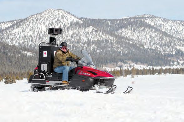
cover F E AT U RE
allel to vehicle motion. If we sweep the exposure window
from back to front, consistently across cameras, the main
artifact is that foreground objects are distorted to appear
thinner than they really are; this doesn’t look bad com-
pared to the kind of image-shear distortion that would
be caused by operating in landscape orientation with the
shutter window moving up or down.
POSE OPTIMIZATION
Accurate position estimates of Street View vehicles are
essential for associating our high-resolution panoramas
with a street map and for enabling an intuitive navigation
experience. We use the GPS, wheel encoder, and inertial
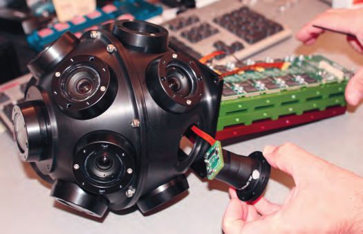
Figure 2. R7 Street View camera system. The system is a navigation sensor data logged by the vehicles to obtain
rosette (R) of 15 small, outward-looking cameras using these estimates. An online Kalman-filter-based algorithm
5-megapixel CMOS image sensors and custom, low-flare, is deployed on the vehicles to provide real-time navigation
controlled-distortion lenses.
information to the drivers. As part of the Street View pro-
cessing pipeline, we use a batch algorithm open sourced by
the R5 system—the fifth generation of a series that we Google (http://code.google.com/p/gpo/wiki/GPO) to achieve
developed in-house, all of which provide high resolution a smoother and locally accurate solution for the pose trajec-
compared to the “lite” vehicles’ off-the-shelf camera. We’re tory. This trajectory is computed at a resolution of 100 Hz,
currently manufacturing and deploying its successor, R7. which is necessary to process laser data and to accurately
Both R5 and R7 are rosettes of small, outward-looking correspond camera pixels to 3D rays in the presence of a
cameras using 5-megapixel CMOS image sensors and rolling shutter.
custom, low-flare, controlled-distortion lenses. Some of Once the pose based on sensor fusion is computed, we
our earliest photos were captured by R2, a ring of eight align or snap the pose to a map of the road network. We
11-megapixel, interline-transfer, charge-coupled device construct a probabilistic graphical model of the network
(CCD) sensors with commercial photographic wide-angle that represents all the known roads and intersections in
lenses. The R5 system uses a ring of eight cameras, like R2, the world. The model includes detailed knowledge about
plus a fish-eye lens on top to capture upper levels of build- one-way streets and turn restrictions (such as no right
ings. Shown in Figure 2, R7 uses 15 of these same sensors turn or no U-turn). Using this model, we optimally trans-
and lenses, but no fish-eye, to get high-resolution images form the sensor pose into accurate road-positioning data.
over an increased field of view—for example, to see down Among other things, this “road-based” pose permits us
to sidewalks even on narrow streets. Other generations to provide navigation controls inside Street View to move
of rosette camera systems—R1, R3, R4, and R6—enjoyed along the road graph, display approximate street address
a brief experimental existence but weren’t deployed in information, and draw blue overlays on the map to indicate
quantity. which roads have Street View coverage.
A big challenge of deploying cameras at scale is reli-
ability, which we addressed through a ruggedized design, NAVIGATING STREET VIEW IMAGERY
well-tested firmware and software, substantial vibration Among the various ways Google Maps surfaces Street
and temperature testing, burn-in tests of every rosette, and View images, the 360-degree panorama is probably the
root-cause failure analysis. The deployed cameras have no most popular. Several mobile and desktop clients lever-
moving parts, unlike some intermediate designs in which age these images to produce an immersive experience
we experimented with mechanical shutters. in which the user can virtually explore streets and cities.
R2’s interline-transfer CCD provides a global electronic This experience becomes even richer as we combine
shutter, but with this sensor architecture it’s impossible to Street View imagery with other data sources. For example,
make the image quality robust for a camera looking into Street View is a powerful tool for finding local businesses,
the sun. We tried mechanical shutters in R3 and R4 but getting driving directions, or doing a real estate search.
settled on CMOS sensors with an electronic rolling shutter Building on the 3D data that we collect as well as Google
for R5 through R7. A key problem in these later designs Maps data, we can place markers and overlays in the
was to minimize the distortion inherent in shooting from scene, resulting in 3D-annotated Street View images.
a moving vehicle while exposing each row of the image at a Given Google’s belief in empowering users, we recently
different time. The cameras must be in portrait orientation opened Street View to user contributions. As Figure 3a
so that the exposure window’s movement is roughly par- shows, users can now correct the location of businesses
34 comput er
r6anq.indd 34 5/27/10 3:28 PM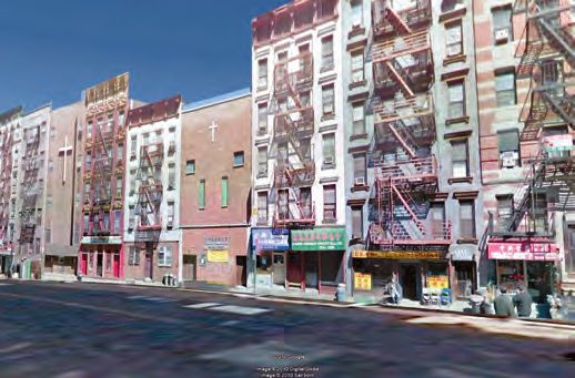
(a)
Figure 4. Imagery from new Street View vehicles is
accompanied by laser range data, which is aggregated and
simplified by robustly fitting it in a coarse mesh that models
the dominant scene surfaces.
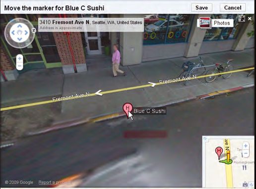
and points of interest by directly dragging markers in
Street View and automatically snapping it to facades. With
this ability, users can build map data with greater accuracy
than ever before.
In addition to overlaying Street View imagery with
local data, we also surface user-contributed photos from
Flickr, Panoramio, and Picasa in Street View. As Figure
(b)
3b shows, users can navigate from Street View pictures
to matching photos, and from there, directly within the
file structure of user photos. This type of bridge between
Google’s images and user-contributed pictures is only a
first step toward unifying navigation and browsing of geo-
referenced images.
LEVERAGING 3D DATA
FOR SMART NAVIGATION
Street View supports a unique 3D navigation mode
known as “click-to-go,” which lets users click their mouse
on a point in the scene and be transported to the image
nearest to that point’s 3D location. As Figure 3c shows,
users can also hover the cursor over the image and see a
(c) floating shape that shrinks in proportion to the depth and
follows the underlying surface’s normal geometry.
Figure 3. Navigating Street View imagery. (a) Users can correct Enabling such a feature requires the creation of a depth
the location of businesses and points of interest by directly map that stores the distance and orientation of every point
dragging markers in Street View and automatically snapping
them to facades. (b) They can also navigate from Street View in the scene. As the imagery has a very high resolution, we
pictures to matching user-contributed photos. (c) With the compute a low-resolution depth map that can be quickly
click-to-go feature, users can click their mouse on a point in the loaded over the network. For 3D navigation, we go fur-
scene and be transported to the image nearest to that point’s ther and create a depth map that only encodes the scene’s
3D location; if they hover their mouse’s cursor over an image, dominant surfaces, such as building facades and roads,
they’ll see a floating shape that shrinks in proportion to the
while ignoring smaller entities such as cars and people.
depth and follows the underlying surface’s normal geometry.
We compute the depth of various points in the scene using
JUNE 2010 35
r6anq.indd 35 5/27/10 3:29 PM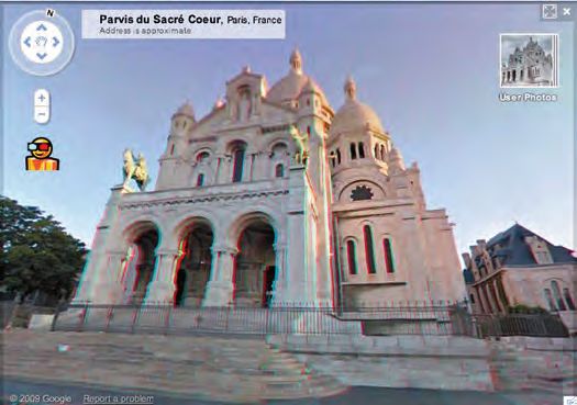
cover F E AT U RE

                                                                                  laser range scans where available and image motion (opti-
                                                                                  cal flow) when laser data isn’t available.
                                                                                      Imagery from new Street View vehicles is accompanied
                                                                                  by laser range scans, which accurately measure the depth
                                                                                  of a vertical fan of points on the two sides and the front
                                                                                  of the vehicle. We aggregate this range data and simplify
                                                                                  it by robustly fitting it in a coarse mesh that models the
                                                                                  dominant scene surfaces. Figure 4 shows an example of a
                                                                                  mesh simplified by plane fitting.
                                                                                      For imagery from older capture platforms, which lacks
                                                                                  laser range data, we recover the depth by computing opti-
                Figure 5. For imagery from older capture platforms, which
                lacks laser range data, depth is recovered by computing           cal flow between successive images of the street facade on
                optical flow between successive images of the street facade       both sides of the vehicle. The optical flow at a given point
                on both sides of the vehicle. The optical flow at a given point   depends on the vehicle’s motion and that point’s depth. To
                depends on the vehicle’s motion and that point’s depth. To        recover only the dominant scene surfaces, we enforce a
                recover only the dominant scene surfaces, a piecewise planar      piecewise planar global model of the facade and fit this to
                global model of the facade is fitted to the optical-flow data
                                                                                  the optical-flow data over a long sequence of images. This
                over a long sequence of images.
                                                                                  process recovers the building facades and road geometry
                                                                                  accurately and robustly. Our optimized depth estima-
                                                                                  tion algorithm runs at about 50 frames per second on a
                                                                                  contemporary desktop. Figure 5 shows an example of the
                                                                                  recovered facade from a top view.
                                                                                      Once the facade model is generated using lasers or
                                                                                  computer vision, we can render a panoramic depth map
                                                                                  by tracing rays from each panorama position. In our im-
                                                                                  plementation, each pixel in the depth map represents a
                                                                                  lookup into a table of 3D plane equations, which enables
                                                                                  the client code to reconstruct the real depth values at
                                                                                  runtime. We further compact this representation using
                Figure 6. Depth map. Once the facade model is generated
                using lasers or computer vision, it’s possible to render a        lossless compression. The encoded depth map is only a few
                panoramic depth map by tracing rays from each panorama            kilobytes in size and can be quickly transported over the
                position. Each pixel in the depth map represents a lookup         network to enable 3D navigation at the front end. Figure 6
                into a table of 3D plane equations, which enables the client      shows an example of a depth map after decoding.
                code to reconstruct the real depth values at runtime.                 Recently, we’ve also used this depth map to synthesize
                                                                                  panoramic 3D anaglyphs, letting users experience depth in
                                                                                  Street View with simple red-cyan eyeglasses. Our approach
                                                                                  uses the known depth to synthesize binocular parallax on
                                                                                  the client side, thereby creating a second displaced view
                                                                                  that replaces the red color channel in the original view to
                                                                                  obtain an anaglyph, as shown in Figure 7.

                                                                                  COMPUTING 3D MODELS FROM LASER DATA
                                                                                     Taking extraction of 3D information even further, we
                                                                                  use Street View data to create photorealistic 3D models
                                                                                  for Google Earth. Traditionally, that service has created
                                                                                  3D city models from nadir or oblique airborne imagery,
                                                                                  resulting in low-resolution facades with little detail—while
                                                                                  suitable for fly-throughs, they didn’t provide a pleasant
                                                                                  walk-through experience. In contrast, 3D facade models
                Figure 7. Panoramic 3D anaglyphs let users experience depth       reconstructed from Street View’s laser scans and imagery
                in Street View with simple red-cyan eyeglasses. Known depth       are high resolution.
                is used to synthesize binocular parallax on the client side,         After filtering out noisy foreground objects, we syn-
                thereby creating a second displaced view that replaces the
                                                                                  thesize a single consistent facade texture by aligning,
                red color channel in the original view.
                                                                                  blending, and mosaicking multiple individual camera

        36        comput er

r6anq.indd 36                                                                                                                                5/27/10 3:29 PM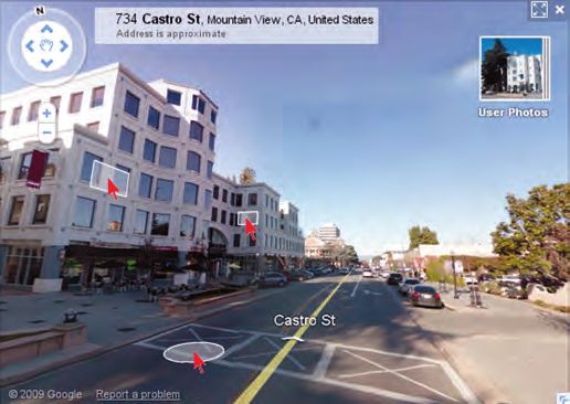
images. To avoid duplication caused by multiple passes,
            and to create a single consistent facade model for an entire
            city, we resolve residual pose inaccuracies between acqui-
            sition runs and determine the most suitable set of final
            3D facade models. We register these models with existing
            airborne models and then fuse them into a single model
            that has high-resolution facades as well as rooftops and
            back sides from an airborne view. Figure 8 shows how
            such a fused model enhances the user experience for a
            walk-through in New York City.

            SERVING IMAGERY TO USERS
               A launch pipeline processes the images captured by               (a)
            the Street View platforms to create user-visible imagery.
            We first stitch the images into panoramas and tile them
            at different zoom levels. The varying zoom levels enable
            clients to view the imagery according to the resolution of
            their viewports and to zoom in on some areas without
            having to download entire panoramas. We then run face
            detection and license-plate detection on all published im-
            agery and blur images accordingly to protect privacy—a
            very compute-intensive step.1
               Street View is currently available in more than 20 coun-
            tries in Australia, Asia, Europe, North America, and Central
            America, with additional coverage under way. This repre-
            sents a huge amount of imagery. To ensure low end-user
                                                                                (b)
            latency, Street View servers are distributed in data centers
            around the world. Moreover, to ensure high availability                   Figure 8. Using Street View data to enhance user walk-
            while minimizing storage costs, we selectively replicate                  through experiences in Google Earth. (a) Original 3D models
            panoramas according to usage patterns.                                    of a New York City scene from airborne data only. (b) Fused
                                                                                      3D model with high-resolution facades. The visual quality is

            S
                                                                                      considerably higher, and many storefronts and signs can now
                                                                                      be easily identified and recognized.
                         treet View has been and continues to be an
                         exciting adventure in global-scale photo col-
                         lection, processing, and serving. The idea of                Dragomir Anguelov is a researcher working on pose esti-
                         driving along every street in the world taking               mation and 3D vision projects for Google Street View. He
                         pictures of all the buildings and roadsides                  is interested in machine learning and its applications to
            seemed outlandish at first, but analysis showed that it                   computer vision, computer graphics, and robotics prob-
                                                                                      lems. Anguelov received a PhD in computer science from
            was within reach of an organized effort at an affordable
                                                                                      Stanford University. Contact him at dragomir@google.com.
            scale, over a period of years—at least in those parts of the
            world where political systems make it possible. The wide
            availability of street-level image data has proved to be very             Carole Dulong is a computer architect leading the Google
            popular with users, delivering useful information that pre-               Street View pipeline team. Her interests include application
            viously wasn’t available. Looking forward, we continue to                 performance and large-scale parallelism. Dulong graduated
                                                                                      as a computer science engineer from Institut Superieur
            explore new interfaces, find better ways to integrate more
                                                                                      d’Electronique de Paris. Contact her at caroled@google.
            user photos, map and photograph places such as malls                      com.
            and museums, and develop platforms to extend coverage
            to other places where cars can’t go.
                                                                                      Daniel Filip is a computer scientist and manager work-
                                                                                      ing on 2D and 3D photo and panorama navigation for
            Reference                                                                 Google Street View, and was the first full-time Street View
                1. A. Frome et al., “Large-Scale Privacy Protection in Google         engineer. His research interests include computational ge-
                   Street View,” Proc. 12th IEEE Int’l Conf. Computer Vision          ometry, computer vision, and computer graphics. Filip
                   (ICCV 09), IEEE Press, 2009; http://research.google.com/           received an MS in computer science from the University of
                   archive/papers/cbprivacy_iccv09.pdf.                               California, Berkeley. Contact him at daniel.filip@gmail.com.

                                                                                                                                     JUNE 2010        37

r6anq.indd 37                                                                                                                                        5/27/10 3:29 PM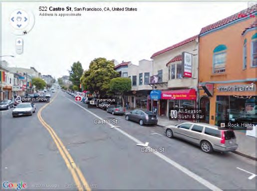
cover F E AT U RE

                Christian Frueh is a computer vision researcher leading       imagery. His research interests include optical flow, seg-
                3D facade model reconstruction and model fusion efforts       mentation, 3D reconstruction, and action recognition.
                for Google Street View. His research interests include 3D     Ogale received a PhD in computer science from the Uni-
                modeling, laser scanning, and localization. Frueh received    versity of Maryland, College Park. He is a member of the
                a PhD in electrical engineering after joint research at UC    IEEE. Contact him at ogale@google.com.
                Berkeley and the University of Karlsruhe. Contact him at
                                                                              Luc Vincent is the Google engineering director responsible
                frueh@google.com.
                                                                              for Street View. His research interests include image pro-
                Stéphane Lafon is a software engineer leading the front       cessing, document analysis, and computer vision. Vincent
                end and serving infrastructure for Google Street View.        received a PhD in mathematical morphology from École
                His research interests include numerical analysis, ma-        Nationale Supérieure des Mines de Paris and an engineering
                chine learning, and clustering. Lafon received a PhD in       degree from École Polytechnique, France. He is a member of
                applied mathematics from Yale University. Contact him at      the IEEE Computer Society. Contact him at luc@google.com.
                stephane.lafon@gmail.com.
                                                                              Josh Weaver is a software engineer leading the vehicle and
                Richard Lyon is a research scientist who leads Google         operational systems team for Google Street View. Weaver
                Street View’s camera development team as well as a Google     received an MS in electrical engineering and computer sci-
                research project in machine hearing. His research interests   ence from Massachusetts Institute of Technology. Contact
                include hearing, electronic photography, and biomimetic       him at jweaver@google.com.
                computing. Lyon received an MS in electrical engineer-
                ing from Stanford University. He is an IEEE Fellow and a
                member of the ACM. Contact him at dicklyon@acm.org.
                Abhijit Ogale is a computer vision researcher who works             Selected CS articles and columns are available for free at
                on extracting 3D information from Google Street View                http://ComputingNow.computer.org.

                Where Are We Headed?
                                                                                           M a y • J u n e 2 010

                Rich Internet applications are a heterogeneous family of
                solutions, characterized by a common goal of adding new
                capabilities to the conventional hypertext-based Web. RIAs
                combine the Web’s lightweight distribution architecture with
                desktop applications’ interface interactivity and computation
                power, and the resulting combination improves all the elements
                of a Web application.

                Read the latest issue of IEEE Internet Computing now!

                www.computer.org/internet

        38       comput er

r6anq.indd 38                                                                                                                                    5/27/10 3:29 PM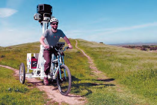
You can also read