Gorman Property Development Planning Study - Village of Union Grove, WI Adopted By Village Board - _, 2018 - Village of ...
←
→
Page content transcription
If your browser does not render page correctly, please read the page content below

Gorman Property Development
      Planning Study
        Village of Union Grove, WI
    Adopted By Village Board - ___________, 2018

                   Prepared By:
Contents

Background ................................................................................................................................................. 2

Section 1: Recommendations .................................................................................................................... 3

Section 2: Current Conditions................................................................................................................... 16

Section 3: Market & Economic Development Analysis ............................................................................ 31

       Appendix A: Design Standards .......................................................................................................... 40

       Appendix B: Market Analysis Data ................................................................................................... 45

Gorman Property Development Planning Study                                                                                                                  1
Village of Union Grove, WI
Background
The Village of Union Grove engaged Foth Companies to provide a future
development planning study for the 43-acre “Gorman” property which is
located at the eastern gateway entry to the community along the south side of
Durand Avenue (Hwy 11). The intent of the Village is to determine an overall
future development plan of the Gorman property that is feasible for the Village
to maximize the development potential of this parcel. Further, it is the
intention of the Village to evaluate the types of commercial/industrial users for
the Gorman site based on current market conditions. The overall planning
study shall be completed with the awareness on how future development may
relate to the “Fonk” property located southwest of the Gorman property along
69th Drive as the combination of the Gorman and Fonk properties may be
under future possible consideration of a tax increment district (TID) to support
the development goals of the Village.

The study herein lays out the current conditions, a strengths/opportunities analysis, and an economic
development market analysis. The resultant analyses are combined to form a series of recommendations to
guide future development of the Gorman property. The recommendations below consist of possible conceptual
development plans of the property and overall Village objectives on how development of the property can be
best pursued and marketed.

Gorman Property Development Planning Study                                                               2
Village of Union Grove, WI

Section 1: Recommendations
Recommended Development Plans
Future conceptual development plans were prepared as part of this study based on the data and analysis
performed in Sections 2 and 3. Overall a series of four (4) conceptual plans are found herein due to the many
opportunities that the Gorman property allows and due to allowing the market to guide the future development
patterns that may be most desired.
Given that the future market will be driving the actual need for future building sizes, property sizes, and land
uses (commercial/industrial) it is recommended that Union Grove utilize these conceptual development plans in
the marketing of the Gorman property site. The concepts display various options to future developers for the
site. Future brokerage firms can directly market new industrial and commercial end-users based on the specific
lot sizes dimensioned which can aid site selectors as they evaluate this potential market.
Note: Concepts #1 & #3 include general building and parking lot layouts in addition to lot configurations. Concepts #2 & #4
do not have the same level of detail but development patterns would be similarly scaled to the depicted lot sizes.
Site Concept #1
Site Concept #1 Plan has the following characteristics below.
Casey’s General Store and Gas Station shown on NW corner (Note: Drawing is conceptual, not to scale,
and doesn’t represent true Casey’s submittal; Casey’s had no final approvals at time of this plan).
Potential Lot and Building Sizes:
o One (1) lot for future commercial user (~ 2 acres and ~21,500 SF of building)
o Four (4) lots for future industrial users per the following:
~ 7.5 acres and ~80,000 SF of building
~ 5.5 acres and ~63,000 SF of building
~ 9.3 acres (5.9 Ac net) and ~52,000 SF of building
~ 9.3 acres (8.6 Ac net) and ~77,000 SF of building
Note: Building sizes are a conservative estimate. Manufacturing and warehousing structures
should be able to have much larger square footages.
Parcels along Hwy 11 frontage easily changed between commercial to industrial users as necessary.
~1000-foot internal road off of 69th Drive adjoining Casey’s south property line. Road meanders south
allowing frontage for four large future industrial parcels.
Casey’s may eliminate access to 69th Drive due to close proximity to Hwy 11 and create access off of new
back frontage court.
Regional stormwater pond along NE property line.
Grading of overall property may require tiering from west to east with the mid-line between the two
southern industrial properties. Extensive retaining walls may also be required in this option.
Financial Estimate: $13.76 M - $15.43 M (Detailed in “Tax Base/Costs” section below)
Infrastructure Need: Detailed in “Tax Base/Costs” section below
Gorman Property Development Planning Study 3
Village of Union Grove, WI
7.5 ACRES
                                    2.0 ACRES       BLDG: 80,000 SF
                                  BLDG: 21,500 SF
            CASEY’S
          (PROPOSED)
           2.0 ACRES

                                                                                            STORMWATER
                 5.5 ACRES
               BLDG: 63,000 SF

                  9.3 ACRES
               5.9 ACRES (NET)
               BLDG: 52,000 SF                                                   9.3 ACRES
                                                                              8.6 ACRES (NET)
                                                                              BLDG: 77,000 SF
                       FL
                         OO
                           DP
                             LA

                              N
                             I

                  WETLAND

                                                                      March 2018
Village of Union Grove - Gorman Property                              1 inch = 200 feet

Site Concept 1
Site Concept #2
Concept #2 displays the same characteristics as Concept #1 with the following additional opportunities:
Regional stormwater now found down in SE corner of property creating larger building areas for potential
parcels.
Lot sizes now maximized along Hwy 11 frontage creating more opportunity for mix of commercial and
industrial users.
Allowance of larger industrial property (10.4 acres) on the southeast portion of property.
Potential Lot and Building Sizes:
o One (1) lot for future commercial user (~ 2 acres and ~21,500 SF of building)
o One (1) lot for future commercial or industrial user (~ 5.1 acres and over 60,000 SF of building)
o Three (3) lots for future industrial users per the following:
~ 5.5 acres and ~63,000 SF of building
~ 9.3 acres (5.9 Ac net) and ~52,000 SF of building
~ 10.4 acres and ~125,000+ SF of building
Note: Building sizes are a conservative estimate. Manufacturing and warehousing structures
should be able to have much larger square footages.
Financial Estimate: $13.89 M - $16.28 M (Detailed in “Tax Base/Costs” section below)
Infrastructure Need: Detailed in “Tax Base/Costs” section below
Gorman Property Development Planning Study 5
Village of Union Grove, WI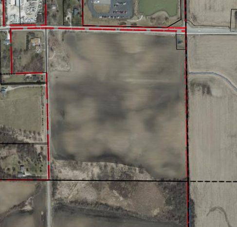
5.1 ACRES
                                            2.0 ACRES

                CASEY’S
              (PROPOSED)
               2.0 ACRES

                                5.5 ACRES

                                                              10.4 ACRES

                                     9.3 ACRES
                                  5.9 ACRES (NET)
                           FL
                             OO
                               DP

                                                                      STORMWATER
                                 LA

                                  N
                                 I

                       WETLAND

                                                           March 2018
    Village of Union Grove - Gorman Property               1 inch = 200 feet

²   Site Concept 2
Site Concept #3
Site Concept #3 Plan has the following characteristics:
Casey’s General Store and Gas Station shown on NW corner (Note: Drawing is conceptual, not to scale,
and doesn’t represent true Casey’s submittal; Casey’s had no final approvals at time of this plan).
Potential Lot and Building Sizes:
o Three (3) lots for future commercial/office users per the following:
~ 2 acres and ~20,000+ SF of building
~2 acres and ~20,000+ SF of building
~2.7 acres and ~25,000+ SF of building
o Two (2) lots for future industrial users per the following:
~ 15.3 acres (11.8 Ac net) and ~135,000+ SF of building
~ 10.4 acres and ~125,000+ SF of building
Note: Building sizes are a conservative estimate. Manufacturing and warehousing structures
should be able to have much larger square footages.
ALTERNATE SETUP: Parcel as large as 22.2 net acres may be created to the south allowing large scale end
user (250,000+ SF).
Parcels along Hwy 11 frontage easily changed between commercial to industrial users as necessary.
~900-foot internal road off of 69th Drive adjoining Casey’s south property line. Road meanders progresses
straight west to east.
Casey’s may eliminate access to 69th Drive due to close proximity to Hwy 11 and create access off of new
back frontage court.
Regional stormwater pond along SE corner of property.
Grading of overall property may require tiering from west to east with the mid-line between the two
southern industrial properties. Extensive retaining walls may also be required in this option.
Financial Estimate: $13.94 M - $16.35 M (Detailed in “Tax Base/Costs” section below)
Infrastructure Need: Detailed in “Tax Base/Costs” section below
Gorman Property Development Planning Study 7
Village of Union Grove, WI
2.0 ACRES         2.0 ACRES             2.7 ACRES
                                     BLDG: 20,000 SF   BLDG: 20,000 SF       BLDG: 25,000 SF

               CASEY’S
             (PROPOSED)
              2.0 ACRES

                         15.3 ACRES
                      11.8 ACRES (NET)
                      BLDG: 135,000 SF                                            10.4 ACRES
                                                                                BLDG: 125,000 SF
                          FL
                            OO
                              DP

                                                                                    STORMWATER
                                LA

                                 N
                                I

                     WETLAND

                                                                         March 2018
    Village of Union Grove - Gorman Property                             1 inch = 200 feet

²   Site Concept 3                                                                                 ²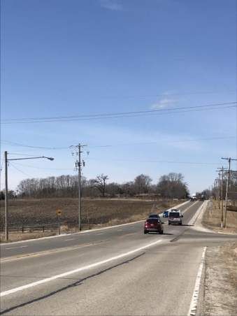
Site Concept #4
Site Concept #4 Plan has the following characteristics:
Casey’s General Store and Gas Station shown on NW corner (Note: Drawing is conceptual, not to scale,
and doesn’t represent true Casey’s submittal; Casey’s had no final approvals at time of this plan).
Potential Lot and Building Sizes:
o One (1) lot for future commercial user (~ 2 acres and ~20,000+ SF of building)
o Three (3) lots for future industrial users per the following:
~ 5.7 acres and ~70,000+ SF of building
~ 8.3 acres and ~100,000+ SF of building
~ 18.3 acres (14 Ac net) and ~175,000+ SF of building
Note: Building sizes are a conservative estimate. Manufacturing and warehousing structures
should be able to have much larger square footages.
Parcels along Hwy 11 frontage easily changed between commercial to industrial users as necessary.
~600-foot internal road off of 69th Drive approximately 800 feet south of Hwy 11. Road progresses straight
west to east.
Regional stormwater pond along NE area of property.
Grading of overall property would require tiering from north to south with the mid-line between the new
roadway.
Financial Estimate: $14.7 M - $18 M (Detailed in “Tax Base/Costs” section below)
Infrastructure Need: Detailed in “Tax Base/Costs” section below
Gorman Property Development Planning Study 9
Village of Union Grove, WI2.0 ACRES
CASEY’S
(PROPOSED)
2.0 ACRES
8.3 ACRES
STORMWATER
5.7 ACRES
18.3 ACRES
14.0 ACRES (NET)
FL
OO
DP
LA
N
I
WETLAND
March 2018
Village of Union Grove - Gorman Property 1 inch = 200 feet
² Site Concept 4Overall Recommendations
There are many contributing aspects that lead to successful
developments of a given area. Below are a series of recommendations
and objectives that will contribute, both directly and indirectly, to the
development of the Gorman property. Many of these future objectives
are also set forth as constructive ways to affirm the Village as a positive
place to live and conduct business.
Land Use & Zoning
Keep existing Comprehensive Plan land uses and zoning districts
“as is” until future developments are officially proposed.
Existing zoning districts of C-1 for commercial uses and I-1 for
industrial uses will suffice for all future proposed uses on the
parcel.
Utilize design standards as mechanism to drive development of
highest and best uses on future developments.
Be open to various opportunities for industrial and commercial
uses as shown in concept development plans.
Allow market to guide actual boundaries of any required land use and zoning amendments.
Absorb costs for developers/landowners of land use and zoning amendments as incentives in future TID.
Tax Increment District
A tax increment district (TID) is a key economic
development tool at the disposable for a Village.
Given there are development barriers not commonly
found on similar sites in the region, and the high tax
base potential with a mix of uses possible on both
the Gorman and Fonk properties, a future TID is
recommended if local borrowing is found to be
unfeasible. A new TID should consider the following
private investments in order to differentiate the
development potential from other parcels in the
immediate region:
o Developer incentives for costs related to
land use/zoning amendments and possible
sewer/water fees (laterals, impact fees, etc.)
o Infrastructure costs including the major
extensions for roads, sewer and water.
o Initial grading and stormwater management
implementation costs.
o Cost recovery for Agricultural Conversion
Fees (2017: $329/acre)
o Allowance for the Village to extend miscellaneous developer incentives that aid in the attraction
of high end business park users that maximize tax base and early TID closing.
Formulation of a TID is recommended immediately in order to prepare the properties for potential users
in line with the Foxconn development schedule and related infrastructure improvements taking place
along the I-94 corridor (by 2020). A possible TID boundary has been under consideration by Village staff
per the inset map found herein.
Possible TID conceptual scenarios are discussed in detail below in the “Tax Base/Costs” section.
Gorman Property Development Planning Study 11
Village of Union Grove, WITax Base/Costs
If TID is used, future tax base will depend on limiting TID costs. Coordinating a development pattern with
limited extension of utilities and frontage roads is most desired.
The difference in tax base between smaller commercial and larger business park uses is negligible. To
maximize tax base potential the priority will be to focus on uses that maximize building footprints and
avoiding uses with large outdoor storage of materials/vehicle needs.
Taking advantage of an increase in tax base and use of TID is highly recommended. The Gorman
property is currently assessed as agricultural practices with an annual tax base of $230/year.
Discussions with the Union Grove assessors and engineers have yielded the following possible scenarios
based on the presented concept plans herein (All projections are conceptual providing base
assumptions):
o Development Concept #1:
Annual Assessment Projection: $13.76 M - $15.43 M
Based on Casey’s at $1.2-$1.5 Mil
Development ranges projected at a conservative estimate of $45/SF -
$450k/developable acre
Building sizes should be much greater than anticipated
Annual Tax Base Projection (~$21 per $1000 mil rate): $288,960 - $324,030/year
o Development Concept #2:
Annual Assessment Projection: $13.89 M - $16.28 M
Based on Casey’s at $1.2-$1.5 Mil
Development ranges projected at a conservative estimate of $45/SF -
$450k/developable acre
Building sizes should be much greater than anticipated
Annual Tax Base Projection (~$21 per $1000 mil rate): $291,690 - $341,880/year
o Development Concept #3:
Annual Assessment Projection: $13.94 M - $16.35 M
Based on Casey’s at $1.2-$1.5 Mil
Development ranges projected at a conservative estimate of $45/SF -
$450k/developable acre
Building sizes should be much greater than anticipated
Annual Tax Base Projection (~$21 per $1000 mil rate): $292,740 - $343,350/year
o Development Concept #4:
Annual Assessment Projection: $14.7 M - $18 M
Based on Casey’s at $1.2-$1.5 Mil
Development ranges projected at a conservative estimate of $45/SF -
$450k/developable acre
Building sizes should be much greater than anticipated
Annual Tax Base Projection (~$21 per $1000 mil rate): $308,700 - $378,000/year
Gorman Property Development Planning Study 12
Village of Union Grove, WI Expenditure Projections:
Anticipated infrastructure cost projections:
Notes: Numbers are conceptually provided by Baxter & Woodman and particular to the
development of the Gorman property, dependent on approved future development patterns (Ex.
Future developments may assume some costs), and subject to formal projections at the time of a
future TID approval.
Water- $501,000
Sewer- $559,000
Other TID expenditure needs:
Road- Cost dependent on where future business access drive is needed along
69th Drive. 69th Drive may require widening for trucking from new access drive
north to Hwy 11.
Stormwater Management/Grading- Cost dependent on future development
pattern. However, regional stormwater management pond and base grading for
future development could occur upfront to get parcels semi pad-ready as part
of a TID.
Incentives – Village may wish to add a desire to spend TID expenditures towards
developer incentives (finish grading, increased architecture, utility connections)
and/or village beautification efforts (gateway signage, Hwy 11 streetscaping).
Possible TID Scenario:
A future TID payoff of ten (10) - twelve (12) years looks very favorable even when
assuming conservative estimates on expenditures and timeframes. All development
concepts yield a conservative estimate of $300,000/year in new taxes. If full buildout of
businesses didn’t happen until year five (5) the overall development should yield well
over $2 Mil in new tax base by year twelve (12) of a TID. A possible expenditure
scenario below is outlined that includes ability for the Village to include village
beautification needs and developer incentives. Overall, there appears to be ample room
between the expected amount of expenditures and the high tax base that is projected
to be created.
Possible Expenditures:
Water- $501,000
Sewer- $559,000
Road Upgrades- $100,000
Grading/Storm- $150,000
Village Beautification- $80,000
Developer Incentives- $150,000-$300,000
Totals- $1.54 Mil – $1.69 M
Tax Base Creation (over 12 years w/ full buildout at year 5): ~$2 Mil+
Difference: $300,000+
Gorman Property Development Planning Study 13
Village of Union Grove, WITarget Industries
With almost all commercial target industries being insufficient in the
Union Grove market the Village should be open to any type of
commercial end user that the market demands. However a focus for
the brokerages commissioned should key upon Restaurants/Eating
Places, Clothing stores, and electronics stores. These commercial i
ndustries have been found as having a minor increase of demand in
the general area.
Look to avoid commercial industries that have an adequate supply
in the Union Grove market including automobile service, gas
stations, and grocery.
Manufacturing, Transportation, and Warehousing are key underserved industries in the region with an
increased demand as Foxconn development begins to take shape along Interstate 94. A focus for the
brokerages commissioned should key upon marketing the manufacturing industry for the Gorman
property.
Union Grove will have to evaluate transportation and warehousing proposals on a case by case basis.
These uses can sometimes be lower tax base producing developments given the need for outdoor
storage and limited usable building square footage. The Gorman property is of smaller size and a tax
base producing development is very necessary if the TID economic development tool is utilized.
Avoid uses with large outdoor storage of materials/vehicle needs. Higher tax base producing
developments result from improvements that maximize the building footprints. This will be especially
important should the Village exercise a new TID to aid development here.
Marketing
Partner with local reputable and knowledgeable commercial/industrial brokerage. Have brokerage
pursue targeted industries displaying all concepts/benefits/incentives of site for future commercial and
industrial businesses.
Pursue brokerage currently knowledgeable in site selection and potential suppliers to Foxconn.
Partner with RCEDC on their available marketing options for site development which will include:
o Adding the property to the RCEDC site selection tool on their website.
o Featuring the property in any appropriate site searches and RFPs.
o Including the property in marketing materials that will be distributed to real estate professionals
both locally and nationally.
Work with the Wisconsin Economic Development Corporation (WEDC) on their available marketing
options. Once property is readily marketable for future development it can be included in the WEDC
“Available Sites” website.
Create webpage on Village website for additional marketing that brokerages, real estate agents, and
local economic development professionals can point to. Incorporate potential development concept
plans and what public investments (incentives, infrastructure costs) in which the Village is willing to
share.
Consider Village streetscaping and beautification as part of development of a TID for Gorman and Fonk
properties per the “Village Beautification/Identification” section below.
Roadways
Internal roadways will largely depend on the developments proposed and access requirements.
Avoidance of a new internal public road, such as a frontage road, will lead to Village savings.
Improvements to the intersection of Hwy 11/69th Drive will have to be considered due to the increase of
residential and business traffic planned to the south on both the Gorman and Fonk properties.
Gorman Property Development Planning Study 14
Village of Union Grove, WIReconstruction of 69th Drive will ultimately be dependent on the type of business proposed for the south
half of the Gorman property (ex. trucking needs) and future development of the Fonk property.
Possible turning lanes for a sole access point to the Gorman property from Hwy 11, midway between
67th and 69th Drives, may be required depending on the developments ultimately proposed.
Sewer
Maximize development potential of property by planning sewer around the perimeter of the Gorman
property. Pursue option of having sewer along Hwy 11 frontage for frontage uses and sewer along the
rear wetlands for southern business park uses. This option will allow the most possibilities for building
footprints within the center of the Gorman property.
Consider installing sewer as part of TID to enable the site to be pad-ready for developments to occur in a
quick fashion.
Water
Maximize development potential of property by planning water around the perimeter of parcel. Pursue
option of having water come from the west along Hwy 11 and traverse down 69th Drive to the south.
Consider installing water as part of TID to enable the site to be pad-ready for developments to occur in a
quick fashion.
Grading & Stormwater Management
Look to position regional pond in one regional location to maximize development potential of property.
A base development grading plan should be engineered for the Gorman parcel that allows for regional
stormwater ponds supporting all future development of site. This basis will allow the Village to
determine true costs for grading/stormwater needs. This will also enable the Village to start pre-
development of the parcel allowing the site to be pad-ready and more marketable for an end user.
Ensure grading allows proper tiering of parcel (dependent on final road configuration) so all building
pads are flat and easily developable.
Village Beautification/Identification
Given that Hwy 11 is the main traveled gateway to the Village from the east, and
that future development (Foxconn) may increase the notoriety of the Village and
this gateway, the following should be considered:
o Invest in gateway beatification measures in the event of TID use including:
New Union Grove gateway signage
Possible use of lighting and/or banner poles from 67th Drive to
downtown intersection of Hwy 45. Utilizing existing electric poles
may be best option for future banners or flag programs.
Consider additional streetscaping efforts where possible along route (landscaping, etc.)
o Investments in Village beautification should be done with thoughtful consideration on branding
as the investment could kick start beautification efforts throughout the Village in the coming
decade in order to establish a new identity throughout the Village.
Design Standards
If the Village utilizes TID to support the development of the Fonk and Gorman properties it is
recommended that design guidelines are adopted to encourage high quality developments for this
geographical area. Such design standards can enable the area to develop in a cohesive way and
promote use of materials and craftsmanship that lead to higher tax base producing improvements.
The Village may choose to adopt the base design guidelines found in Appendix A of this study as part of
the overall adoption of this study or develop additional guidelines outside the approval of this study.
Gorman Property Development Planning Study 15
Village of Union Grove, WISection 2: Current Conditions Planning Area The Gorman property is situated south of State Highway 11 (Durand Avenue) and sits at the eastern gateway to the Village of Union Grove. The property is approximately 43 acres consisting mostly of tilled farmed fields with the exception of wetland areas to the south. The Fonk property lies directly southwest of the Gorman property along 69th Drive. The base location map can be found per the attached map. Regional Location The overall location of the Village of Union Grove and the subject property in relation to the regional area is found on the map inset. The subject property is located in Racine County at the eastern gateway to the Village along Wisconsin Highway 11 (Durand Avenue). The location is approximately 4 miles due west of the Interstate 94 interchange. The Village of Union Grove borders the Town of Yorkville along the majority of its limits with the exception of an area to the west bordering the Town of Dover. The Kenosha County line is fairly close to Union Grove’s southern border where the Town of Paris exists. Gorman Property Development Planning Study 16 Village of Union Grove, WI
ÿ
ÆK
ÿ
Æ
H
VILLAGE OF
TOWN OF TOWN OF CALEDONIA
NORWAY RAYMOND
.
"45
ÿ
Æ
V
Æ
%75 Æ
%
20 VILLAGE
ÿ
Æ
H
ÿ
OF MT
Æ A PLEASANT
ÿ
Æ
C
TOWN OF
TOWN OF YORKVILLE
DOVER
VILLAGE OF
L AK
E
STURTEVANT
G LE
EA
VILLAGE
OF UNION
§
¦
¨ 94
GROVE
Æ
% 11
.
" 41 FOXCONN SITE
RACINE COUNTY
KENOSHA COUNTY ÿ
Æ
KR
SITE LOCATION
.
" 45
ÿ
Æ
A
ÿ
Æ
BB
ÿ
Æ
EA
ÿ
ÆE
VILLAGE
OF SOMERS
TOWN OF Æ
%142 TOWN OF
PARIS
ÿ
Æ
MB
BRIGHTON
ÿ
Æ
H
ÿ
ÆD
ÿ ULINE AMAZON
Æ
UE SHIPPING
SUPPLIES
SHIPPING/
FULFILLMENT
CENTER
²
TOWN OF
GORDON
CITY OF SOMERS
KENOSHA
ÿ
FOODS
ÆNN KENOSHA REGIONAL
AIRPORT
Village of Union Grove - Gorman Property
Municipal Boundary
Regional Property Location
February 2018 Q:\Union Grove WI V\18U003.00\GIS\mxd\18U003.00 Union Grove Base Map 01302018.mxd Railroad
Roads
0 0.5 1 MilesLand Use
Current Land Use
The current land use of the Gorman property is agricultural.
Surrounding the property the following current land uses are found:
North: Commercial retail development (Note: The “Maple
Grove” lift station is found at the very northeast corner of the
subject property)
West: Residential to the northwest and agricultural
predominantly west
South: environmental (wetlands) with agricultural uses further
southwest, south, and southeast
East: Agricultural uses throughout
Future Land Use
The Village of Union Grove has an adopted Comprehensive Land Use Plan as part of the Multi-Jurisdictional
Comprehensive Plan for Racine County: 2035 as completed in November 2009. The map displays a future land
use similar to the existing zoning of the parcel reserving the northern upper portion of the property for
“Commercial” uses and the southern portion for “Industrial” land uses. Low density residential surrounds the
property to the west, south, and northeast. Commercial uses to the north and agricultural uses to the east (See
attached map).
Previous to the multi-jurisdictional plan, the Village had an adopted joint comprehensive plan known as A Land
Use Plan for the Village of Union Grove and the Town of Yorkville: 2020 (adopted December 2003). This plan
outlined specific objectives for future commercial and industrial uses in the Village for various target areas.
While the Gorman property wasn’t listed as a target area at that time; it is important to note the objectives for
future commercial and industrial development from that plan as follows:
Commercial Area Objectives
1) To encourage businesses that provide services to the community, and contribute to the quality of life, or the
environment for the citizens in the Town of Yorkville and the Village of Union Grove.
2) To encourage businesses that will provide jobs that promote long-term employment, and growth of the tax base.
Types of Acceptable Commercial Development:
1) Small businesses, including but not limited to such business types as:
a. Computer assembler and sales.
b. Equipment and tool rental.
c. Copying or printing.
d. Technical campus.
e. Auto/truck/motorcycle new parts supply.
2) Service industries, including but not limited to:
a. Health and fitness clubs.
b. Internet service providers.
3) Business/professional offices.
4) Small retail centers.
Gorman Property Development Planning Study 18
Village of Union Grove, WIDURAND AVENUE 11
69TH DRIVE
VILLAGE OF UNION GROVE
VILLAGE OF UNION GROVE
TOWN OF YORKVILLE
TOWN OF YORKVILLE
PROJECT BOUNDARY
²
Village of Union Grove - Gorman Property Suburban Residential (1.5 to
3.0 AC/DU)
Industrial Municipal Boundary
2035 Land Use Plan
Agricultural, Rural
Low Density Residential Right-of-Way
Residential, and Open Lan
(19,000 SF to 1.49 AC/DU)
Isolated Natural Resource Parcels
Medium Density Residential Area
Q:\Union Grove WI V\18U003.00\GIS\mxd\18U003.00 Union Grove Base Map 01302018.mxd
February 2018 (6,200 to 18,999 SF/DU)
Surface Water
Streets and Highways
Commercial
0 150 300 FeetIndustrial Area Objectives
1) To encourage businesses that provide services to the community and surrounding areas, while contributing to
the quality of life, and/or the environment for the citizens in the Town of Yorkville and the Village of Union Grove.
2) To encourage businesses that would provide long-term jobs that promote sustained economic growth and
stability to the Town of Yorkville, Village of Union Grove and surrounding communities.
3) To encourage nonhazardous operations. Operations that generate hazardous compounds, heavy metals, and
other by-products are not considered compatible with the will of the Town of Yorkville residents (refer to surveys
conducted in 1995 and 2000) and the Village of Union Grove.
4) To encourage businesses that would not adversely affect infrastructure.
5) All businesses must have adequate access and egress to major right-of-ways, without causing traffic safety
hazards, or traffic flow problems.
6) All businesses must be compatible with emergency and utility services available presently.
7) All businesses must supply drainage and site plans that must show that:
a. Surrounding property owners will not receive more water run-off than with current conditions.
b. The property and building(s) will complement adjacent lands and properties.
Types of Acceptable Industrial Development
1) Manufacturing, including but not limited to:
a. Plastics forming/molding.
b. Assembly.
c. Door/window manufacturing.
d. Automotive parts manufacture.
2) High tech/electronics.
3) Fabrication.
Property Data
The subject property is currently privately owned under the name Chris and Susan Gorman. There is a 2017
assessment of $10,600 (assessed as primary agricultural use) and 2017 taxes at $230.20. The parcel is currently
vacant having no structures, however an older concrete building foundation exists in the northwest corner.
Zoning
The property is currently split zoned with the northerly 300 feet being C-1 General Commercial District and I-1
Light Industrial District to the south (see attached map). The subject property is adjoined by similar commercial
zoning to the north along Durand Drive, residential zoning is found along Durand Drive to the northwest, and
agricultural zoning borders the property throughout all other locations. The requirements of the zoning districts
found on the subject property are found following the zoning map.
Gorman Property Development Planning Study 20
Village of Union Grove, WIRD-90
RS-90
A-2
A-2
C-1
C-1
B-3
DURAND AVENUE 11
P-1
C-1
RS-90
R-2
69TH DRIVE
I-1
A-2
A-2
VILLAGE OF UNION GROVE
VILLAGE OF UNION GROVE
TOWN OF YORKVILLE
TOWN OF YORKVILLE
PROJECT BOUNDARY
RS-90
RS-90
²
Village of Union Grove - Gorman Property Village of Union Grove Zoning Town of Yorkville Zoning Municipal Boundary
Single Family Residence (RS-80) Suburban Residential
Current Zoning
Right-of-Way
District (Unsewered) (R-2)
Single Family Residence (RS-90) Parcels
Commercial Service
February 2018 Q:\Union Grove WI V\18U003.00\GIS\mxd\18U003.00 Union Grove Base Map 01302018.mxd District (B-3)
Two Family Residence (RD-90) Surface Water
General Farming District II
General Commercial (C-1) (A-2)
0 150 300 Feet Light Industrial (I-1)
Institutional and Park (P-1)C-1 General Commercial District
The C-1 general commercial district is intended to provide areas for the business and commercial needs of the village.
(a) Generally. The uses in this section are permitted in the C-1 general commercial district, provided that they shall be retail
establishments selling and storing merchandise.
(b) Permitted uses. Permitted uses for all commercial districts are subject to Plan Commission review and approval of site plan
and architectural plans and Plan of Operation. Permitted uses shall be as follows: (1) Antique and collectors' stores. (2)
Appliance stores. (3) Bakeries. (4) Banks, savings and loan associations, and other financial institutions (drive-in facilities for
such uses are conditional uses). (5) Barbershops. (6) Beauty shops. (7) Bookstores. (8) Bowling alleys. (9) Business offices. (10)
Camera and photographic supply stores. (11) Clinics. (12) Clothing and dry goods store. (13) Commercial child care facilities. (14)
Confectioneries. (15) Delicatessens. (16) Dental clinics. (17) Department stores. (18) Drugstores. (19) Electronic equipment sales,
services and repairs. (20) Fish markets. (21) Florists. (22) Fruit stores. (23) Funeral homes. (24) Furniture stores. (25) Furriers and
fur apparel. (26) Gift stores. (27) Grocery stores. (28) Hardware stores. (29) Hobby and craft stores. (30) Jewelry stores. (31)
Lunchrooms and cafes. (32) Meat markets. (33) Medical and Dental clinics. (34) Music stores. (35) Newspaper and magazine
stores. (36) Optical stores. (37) Packaged beverage stores. (38) Paint, glass, and wallpaper stores. (39) Pet grooming, not
including boarding. (40) Photography studios. (41) Physical fitness centers. (42) Professional offices. (43) Public utility offices.
(44) Publishing houses. (45) Restaurants (drive-in facilities for such uses are conditional uses). (46) Self-service laundries and dry
cleaning establishments. (47) Shoe stores and leather goods stores. (48) Sporting goods stores. (49) Stationery stores. (50)
Supermarkets. (51) Tailor or dressmaking shops. (51) Theaters (site plan review of parking). (52) Tobacco stores. (53) Travel
agency. (54) Variety stores (site plan review of parking). (55) Vegetable stores. (56) Other uses similar to or customarily
incidental to any of such uses. Existing residences may be expanded and repaired in compliance with the applicable
requirements of the R-80 single-family residential district but no new residence may be built.
(c) Permitted accessory uses. Permitted accessory uses shall be as follows: (1) Garages for storage of vehicles used in conjunction
with the operation of the business or for occupants of the premises. (2) Off-street parking areas. (3) Residential quarters for the
owner, proprietor, commercial tenant, employee or caretaker located in the same building as the business above the first floor
level subject to the approval of the plan commission; rental of efficiency and one-bedroom apartments on a non-ground level,
provided there shall be a minimum floor area of 350 square feet for a one bedroom apartment, and 650 square feet for a two-
bedroom apartment, subject to the approval of the plan commission. (4) Essential services.
(d) Conditional uses. Conditional uses shall be as follows: (1) Drive-in establishments for restaurants serving food and beverages
normally consumed on premises. (2) Crematory service. (3) Gasoline service stations, automobile and truck rental services, and
automobile washing. (4) Veterinary clinics, provided that no service, including the boarding of animals, is offered outside of an
enclosed building. (5) Bars and taverns. (6) Utilities. (7) New and used automobile, aircraft, and marine craft sales and the sale
of tires, batteries, and other automotive, marine, and aircraft accessories. (8) Radio and television transmitting and receiving
stations. (9) Printing. (10) Automotive sales and service. (11) Lawn, garden and recreational vehicle sales and service. (12)
Motels and hotels. (13) Building supply stores. (14) Construction services, including general building contractors, carpentry,
wood flooring, concrete services, masonry, stonework, tile setting, plastering services, roofing, sheetmetal services, and water
well drilling services. (15) Transmitting towers, receiving towers, relay and microwave towers without broadcast facilities, or
studios. (16) Freight forwarding services, packing and crating services, and petroleum bulk stations. (17) Warehousing and
retail/wholesale sales of electrical apparatus and equipment, wiring supplies and construction materials; hides, skins and raw
furs; outdoor storage as permitted by the plan commission. (18) Cemeteries. (19) Fuel oil, bottled gas, and ice dealers. (20) Gun
stores. (21) Clubs. (22) Dancehalls. (23) Fraternities. (24) Lodges. (25) Convenient-cash businesses, provided that no other
convenient cash business is located within 2,500 feet and the business is located at least 250 feet from a residential district.
(e) Restricted conditional uses.
The following uses are permitted as conditional uses, provided all principal structures and uses are not less than 100 feet from
any residential district lot line: (1) Bus depots. (2) Rail depots.
Area, height and yards.
In the C-1 general commercial district, the height, the minimum dimension of yards, and the minimum area shall be as follows:
(1) Lots. - Width. 1. The minimum yard width for fireproof construction shall be 50 feet. 2. The minimum yard width for
nonfireproof construction shall be 75 feet. b. Area. The lot area shall be the minimum required to meet all setback and parking
requirements.
(2) Buildings. The maximum height of buildings shall be 45 feet. b. There shall be no maximum height of buildings with fireproof
construction.
(3) Yards.
a. Side yards.
1. There shall be a minimum nine-foot side yard on every business building property where the commercial
district is adjacent to a residential district.
2. The minimum side yard for nonfireproof construction shall be ten feet.
Gorman Property Development Planning Study 22
Village of Union Grove, WIb. Street yard. The minimum street yard shall be five feet.
c. Rear yard.The minimum rear yard shall be 15 feet.
I-1 Light Industrial District
The I-1 light industrial district is intended to provide for industrial, commercial, and manufacturing uses which, on the basis of
physical and operational characteristics, would not be detrimental to the immediate surrounding area or to the Village as a
whole by reason of smoke, odor, noise, dust, liquid, traffic, physical appearance, or other similar factors; and to establish such
regulatory controls as will reasonably ensure compatibility within the surrounding areas in these respects.
(a) Permitted uses. Permitted uses shall be any use permitted to the commercial districts. (b) Conditional uses allowed in the I-
1 light industrial district shall be as follows: (1) All uses involving the manufacture of goods within the confines of a
permanent building and in which any smoke, noise, dust, flash, liquid, or odor produced in the manufacturing process is
either not produced or is confined within the building. (2) All uses involving the fabrication of materials within the confines
of a permanent building and in which any smoke, dust, flash, liquid, noise, or odor produced in the fabrication process is
either not produced or is confined within the building. (3) All uses involving the provision of an office or service which is
either manufacturing or fabrication-related and not permitted in business/commercial districts, confined within a
permanent building, and in which any smoke, dust, flash, heat, noise, liquid or odor produced by such service uses is either
not produced or is confined within the building. (4) Commercial Kennels. (5) Enclosed as well as screened areas for the
storage of materials, other than explosive or flammable materials or substances, used in the manufacturing or fabrication
process. (6) Offices normally auxiliary to the principal uses. (7) Garages for the storage of licensed vehicles used in
conjunction with the operation of the industrial uses. (8) Auxiliary power generators. (9) Screened off-street parking and
loading areas. (10) Non-flashing signs. (11) The storage of not more than 2,000 gallons of fuel and petroleum products for
use incidental to the principal use, and upon specific approval of the Plan Commission. (12) Residential quarters for the
owner or hired caretaker provided that such quarters are in the principal building, not more than 750 square feet in area,
no more than two (2) bedrooms, and not for rent, lease or separate sale.
Standards and Plan Commission review. The above permitted and conditional uses are subject to Plan Commission review
and approval of site plan and architectural review (see Section 118-821) and Plan of Operation (See Section 118-822). In
addition, the permitted uses are subject to the following: (1) No merchandise shall be handled for sale or service rendered
on the premises except such as is incidental or accessory to the principal permissible use of the premises, except for sales or
service to industrial, commercial, or manufacturing customers or sales primarily by Internet or telephone. (2) All operations
and activities of all uses within this district shall be conducted wholly inside a building unless granted exception by the plan
commission. Outdoor storage areas shall be screened from view. (3) No continuous or intermittent noise from operations
greater than the volume and range of noise emanating from vehicular traffic or its equivalent in noise shall be detectable at
the boundary line of any residential district. (4) No toxic matter, noxious matter, smoke or gas, and no odorous or
particulate matter detectable beyond the lot lines shall be emitted. (5) No vibrations shall be detectable beyond the lot
lines. (6) No glare or heat shall be detectable beyond the lot lines. (7) Exterior lighting fixtures shall be shaded wherever
necessary to avoid casting direct light upon any residence district or into public streets or parks. (8) The storage or use of
chemicals, either solid, liquid or gas, shall be subject to the following conditions: a. The storage, utilization, or
manufacturing of materials or products ranging from incombustible to moderate burning is permitted. b. The storage,
utilization or manufacturing of materials or products ranging from free to active burning is permitted, provided the
materials or products shall be stored, utilized, or manufactured within completely enclosed buildings having incombustible
exterior walls and protected throughout by an automatic fire extinguishing system. c. The manufacture of flammable
materials which produce explosive vapors or gases is prohibited.
Area, height and yards. In the I-1 light industrial district, the height, the minimum dimensions of yards, and the minimum
area shall be as follows:
(1) Lots. a. The minimum width shall be 100 feet. b. The area shall be the minimum required to meet all setbacks and
parking and loading requirements.
(2) Buildings. The maximum building height shall be 35 feet.
(3) Yards.
a. Side yards. There shall be a 50-foot side yard on every industrial property where the industrial district is adjacent to a
residential district. 1. For a principal building, the minimum side yard shall be 20 feet. 2. Reserved.
b. Street yard. The minimum street yard shall be 25 feet.
c. Rear yard. The minimum rear yard shall be 40 feet. d. Any commercial or manufacturing entity located within the I-1 zone
will conform to all I-1 dimensions as set out above.
Gorman Property Development Planning Study 23
Village of Union Grove, WIAccess
The subject property is bordered by two (2) roads including Durand Avenue (Hwy 11)
on the north and 69th Drive on the west. Durand Avenue is controlled by the State of
Wisconsin and consists of a two-lane rural cross section roadway that has a speed
limit of 35 miles per hour along the subject property. 69th Drive is controlled by the
Village and consists of a two-lane rural cross section roadway (Class B Highway) that
has a speed limit of 45 miles per hour.
As of the time of this study there were no plans for existing road upgrades/designs of
69th Drive or Hwy 11 surrounding the subject property. WisDOT was contacted about
access possibilities along Hwy 11 and it was found that they would like to limit access
points along the Gorman property wherever possible. Access points along state
highways are usually desired at least 600 feet from surrounding intersections. The Gorman property has
approximately 1,300 feet of linear frontage along Hwy 11 which could allow the possibility of a full access point
towards the center. However, all actual determinations of highway access by WisDOT are based on formal
development submittals.
Considerable highway upgrades are being made east of the subject property along Interstate 94 (approximately
4 miles east). The interstate will be expanded to eight (8) lanes and the Hwy 11 interchange ramps and bridges
will receive a complete overhaul from 2018-2019.
Traffic Counts
The Wisconsin Department of transportation (WisDOT) logs traffic counts at various locations and evaluation
dates throughout the state. Per the WisDOT the following traffic counts are found around the subject area to
date:
Hwy 11 between 67th and 69th Drives
o 2017 Average Daily Traffic: 12700
o 2014 Average Daily Traffic: 8400
o 2011 Average Daily Traffic: 7800
th
69 Drive south of Hwy 11 a ¼ mile
o 2011 Average Daily Traffic: 490
Hwy 11 at 14th Avenue (1/4 mile west of subject property)
o 2017 Average Daily Traffic: 15300
o 2014 Average Daily Traffic: 9900
o 2011 Average Daily Traffic: 8000
Hwy 11 at the west end of the I-94 Interchange (4 miles east of subject property)
o 2017 Average Daily Traffic: 10300
o 2014 Average Daily Traffic: 7100
o 2008 Average Daily Traffic: 6300
Gorman Property Development Planning Study 24
Village of Union Grove, WIUtilities Water A 12” water main currently exists along the northern half of the Hwy 11 right-of-way in front of the Gorman property that may serve future uses along the northern Hwy 11 frontage of the Gorman property. To service the rest of the property Village Engineers Baxter & Woodman has provided a possible future design showing an extension of a new 12” water main to come off of existing water main to the west at Lincolnwood Drive that would travel south along 69th Drive (see map attached). The new 12” extension could allow main/laterals to service future developments of the Gorman property and also be sufficient for future developments of the Fonk properties to the south. Gorman Property Development Planning Study 25 Village of Union Grove, WI
Sanitary
Sanitary sewer is currently found at the northeast corner of the Gorman property where the Maple Grove lift
station is located. Sewer extends north from the lift station along 67 th Drive servicing the various residential and
commercial developments north of Hwy 11. In order to service the subject property Baxter & Woodman has
provided a future design that can maximize the future development potential of the Gorman property consisting
of extending new main west along the Hwy 11 frontage to service developments on the northern end of the
Gorman property. A new 8” sanitary main would also extend south of the Maple Grove lift station to the south
end of the Gorman property. The sewer main would then traverse west along the wetland boundary along the
southern lot line to 69th Drive. This new sewer main would allow capacity to service the Fonk properties to the
south with various 4”-8” mains. A new lift station would be also required on the eastern Fonk property as it
develops in the future. In all, the sewer service proposed would maximize the development potential of the
Gorman property by not interrupting development possibilities through the middle of the parcel.

Gorman Property Development Planning Study                                                                         26
Village of Union Grove, WI
Storm
Storm sewer for the area consists of ditches along the roadways and a larger stormwater pond as part of the
Piggly Wiggly development on the north side of Hwy 11. The pending Casey’s General Store development is
currently looking to provide their own stormwater management needs on their site.

There is no stormwater management on the Gorman property at this time and the future development concepts
and recommendations of this study take this into account by setting aside an estimated amount of acreage for
stormwater management facilities based upon full buildout potential of the site.

Natural Resources
Wetlands & Environmental Corridor
A wetland structure is found along the full southern portion of the subject property (see map attached). Actual
wetland boundaries will have to be surveyed by a qualified surveyor, however, the wetland complex takes up
approximately 4 acres of the southwest corner. This same area is currently mapped as a secondary
environmental corridor as characterized by the Southeastern Wisconsin Regional Planning Commission. Once
the wetland is officially surveyed any new development would be required to have setbacks up to fifty (50) feet
for future buildings.

Floodplains
Federal Emergency Management Agency (FEMA) floodplains are found along the far southwest corner of the
property primarily matching where the wetlands boundaries will occur (see map attached).

Topography
The property has a high point at the northwest corner along the Hwy 11/69th Drive intersection and generally
slopes to the eastern and southern borders (see map attached). A difference of approximately twenty-five feet
of slope is found from west to east/south (750’ – 722’).

Gorman Property Development Planning Study                                                                    27
Village of Union Grove, WI
744 728 734
0
73
764 766
2
730
73
734
0
75
6
73
740
8
736
73
738
75
740
8
758
722
8
73
74
6
73 6
0
740
75
8
73
73 4
8
73 2
73 0
73
766
4 724
75
72
722
754
6 762
2
11
76
DURAND AVENUE
724
7
72 28
6
760
750
768
764
746
758
6
4
72
72
756
72
718
0
752
724
2
728
8
0
6
4
2
72
748
73
73
73
73
73
6
74 71
4
74 8
71
0
746
74
8
2
6
75
74
720
4
71
8
72
74
728
4
730
2 742
736
75
69TH DRIVE
74
746 0
744
716
714
738
742 734
720
722
724
726
738
73
2
742
740 74
7 0
73 36
73
734
0
4 VILLAGE OF UNION GROVE
VILLAGE OF UNION GROVE
728
73 TOWN OF YORKVILLE
TOWN OF YORKVILLE
75
0 2
734
736
746
72
4
760
PROJECT BOUNDARY 726
756
754
752
6
744
2
742
738
71
72
732
728
4
718
71
724
8
74
²
716
748 714
722
750 740
720
6
752 754
72
Village of Union Grove - Gorman Property Wetland (WDNR) Index LiDAR Contour (2010) Municipal Boundary
100-Year Floodplain (FEMA) Intermediate LiDAR Contour
Environmental and Topography
Right-of-Way
(2010)
Isolated Natural Resource
Area (SEWRPC) Parcels
Q:\Union Grove WI V\18U003.00\GIS\mxd\18U003.00 Union Grove Base Map 01302018.mxd
February 2018
Surface Water
0 150 300 FeetCurrent Developments
During the time of authoring this study a variety of important developments that have the ability to impact the
future development pattern of the subject property are occurring in and around the area as follows:
Casey’s General Store – An approximate 4,700 square foot Casey’s General Store is currently under proposal for
the Gorman property to the Village. Casey’s is looking to locate the store in the far northwest corner of the
subject property. The overall site consists of the general store, six (6) gasoline pumps, and associated site needs
for parking, lighting, landscaping, and stormwater. Access to the Casey’s is currently anticipated from 69th Drive
and off of a future frontage road to the south. The overall development concepts presented in this study take
into account how the Casey’s development affects the balance of development on the Gorman property.
Fonk Property Development – A conceptual development is taking place south of the Gorman property known
as the “Fonk” property development. The Fonk development includes property on both the west and east side
of 69th Drive. The utility mapping and the sewer service area portions of this study discuss briefly how the Fonk
property is intended to be served upon future development. At this time the Fonk property is conceptually
being proposed for single family parcels to the west matching current densities found in the area. Multi-family,
duplex, and CBRF uses are also being proposed just west of 69th Drive and no formal uses are proposed on the
Fonk parcel found immediately east of 69th Drive. No formal approvals have been given to the Fonk property
developments as of the time of this study.
The Fonk parcel has recently been annexed to the Village of Union Grove and the sewer service area by SEWRPC.
Interstate 94 Widening – As previously mentioned in the roadways section above the WisDOT is starting the
widening and improvements of Interstate 94 in 2018 with a conclusion in December 2019. The improvements
will widen the interstate to eight (8) lanes and will include numerous interchange improvements including the
ramp and bridge replacements at Hwy 11. This interchange is the primary access from the east to the Village
consisting of a four (4) minute drive from the interstate to the Village borders.
Town of Yorkville Developments – Due to the Foxconn development occurring in the near future, the Town of
Yorkville is embarking on new planning effort for future incorporation as a village. The incorporation is being
considered during 2018 with an April referendum. The Town previously was considering amendments to their
2035 Land Use Map and possible utility extensions from the City of Racine for future services. As of January
2018, the Town has postponed any land use and utility plans until the incorporation petition takes its course.
For purposes of Union Grove’s planning of the Gorman property it should be known that the future land use
decisions previously being considered consisted of the following below, which is all two (2) miles east of the
Gorman property.
Change approximately two (2) square miles between Braun Road and CTH KR to Medium Density
Residential uses (6,200 to 18,999 SF per dwelling unit).
Change approximately four (4) square miles between Braun Road going north to around Spring Street
(along the I-94 corridor border including along Hwy 11) to Urban Reserve Area. The Urban Reserve Area
is defined as an area that could house a variety of commercial, industrial, and residential uses and are
dependent on Town approvals.
Such future land use changes by the Town, and subsequent development of the uses in relation to Foxconn,
would make the Gorman property an extremely desirable location for businesses and commercial supporting
uses.
Gorman Property Development Planning Study 29
Village of Union Grove, WIFoxconn – From 2018 to 2020 the world employment giant Foxconn will be building their 20+ million square foot electronics manufacturing facility in the Village of Mount Pleasant. The development will be located just east of Interstate 94 between the CTH KR and Hwy 11 interchanges. The development is expected to create upwards of 13,000 jobs and require the need for over 100 supplier companies that may require the need to locate close to the Foxconn facility. As part of the development, utilities will initially be brought from the City of Racine out to the Interstate 94 corridor area. Further, the roadways surrounding the Foxconn facility, and other surrounding areas created for the future business park, are all scheduled for major upgrades and reconstruction. The roadways currently being designed include Braun Road, CTH KR, and Hwy 11 east of I-94. The reconstructions of the roadways will include pedestrian pathways, boulevards, and multiple lane additions from the rural cross section roadways the predominantly are found today. The initial 13,000 employees will be within five (5) miles from the Gorman property to the front door of Foxconn as traveled by Hwy 11, Braun Road, or CTH KR (see map inset).
You can also read