HOLY CROSS COLLEGE DEVELOPMENT MOBILITY MANAGEMENT PLAN - Amazon AWS
←
→
Page content transcription
If your browser does not render page correctly, please read the page content below
Holy Cross College Development, Drumcondra
                                             11/05/2021
Mobility Management Plan

Reference Number 30060314

HOLY CROSS COLLEGE DEVELOPMENT
MOBILITY MANAGEMENT PLAN

                                                      d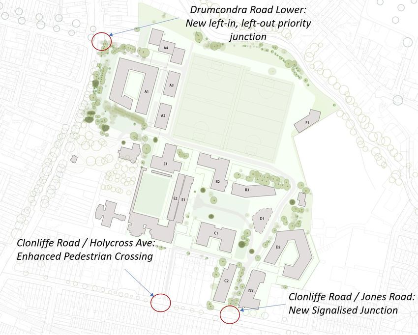
HOLY CROSS COLLEGE LANDS DEVELOPMENT
  IDENTIFICATION TABLE
                            CWTC Multi Family ICAV acting on behalf of its sub-fund DBTR
  Client/Project owner
                            DR DR1 Fund
  Project                   Holy Cross College, Drumcondra

  Study                     Holy Cross College Development – Mobility Management Plan

  Type of document          Draft report

  Date                      11/05/2021

  Reference number          30060314

  Number of pages           62

  APPROVAL
  Version   Name                           Position          Date        Modifications
                         Bridget           Senior
            Author                                       06/11/2020
                         Fleming           Consultant
            Checked      Connor            Senior
    1                                                    06/11/2020      Draft Report
            by           Heyward           Consultant
            Approved
                         A Archer          Director      06/11/2020
            by
                         Arantxa           Principal
            Author                                       11/05/2021
                         Martinez-Peral    Consultant
            Checked      Andrew
    2                                      Director      11/05/2021      For Planning
            by           Archer
            Approved     Andrew
                                           Director      11/05/2021
            by           Archer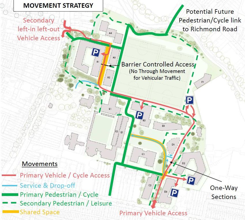
TABLE OF CONTENTS

1.             INTRODUCTION                                                  7
1.1            OVERVIEW                                                      7
1.2            SITE OVERVIEW                                                 7
1.3            MOBILITY MANAGEMENT PLAN APPROACH                             8
1.4            REPORT STRUCTURE                                              9

2.             MOBILITY MANAGEMENT: CONTEXT                                10
2.1            WHAT IS MOBILITY MANAGEMENT?                                10
2.2            THE BENEFITS OF MOBILITY MANAGEMENT                         10
2.3            MOBILITY MANAGEMENT PLAN OBJECTIVES                         10
2.4            MAKING RESIDENTIAL MOBILITY MANAGEMENT PLANS WORK           11

3.             CURRENT TRANSPORT POLICY, PLANS AND STRATEGY REVIEW         12
3.2            NATIONAL POLICY CONTEXT                                     12
3.3            REGIONAL AND LOCAL POLICY CONTEXT                           15

4.             PROPOSED DEVELOPMENT                                        18
4.1            PROPOSED DEVELOPMENT                                        18
4.2            PEDESTRIAN & CYCLE ACCESS AND CIRCULATION                   19
4.3            VEHICULAR ACCESS & CIRCULATION                              23
4.4            NETWORK IMPROVEMENTS                                        25
4.5            CAR PARKING                                                 28

5.             BASELINE TRANSPORT REVIEW                                   31
5.1            OVERVIEW                                                    31
5.2            THE SITE AND SURROUNDING LAND USE                           31
5.3            WALKING PROVISION                                           32
5.4            CYCLING PROVISION                                           37
5.5            PUBLIC TRANSPORT PROVISION                                  39
5.6            EXISTING ROAD NETWORK                                       41
5.7            COMMITTED TRANSPORT PROPOSALS IN AREA                       41
5.8            OTHER TRANSPORT PROPOSALS IN AREA                           43

6.             PRE-OCCUPATION BASELINE MODE SHARE                          46
6.1            PURPOSE OF THE BASELINE                                     46
6.2            MODE CHOICE                                                 46
6.3            CAR OWNERSHIP                                               48

Holy Cross College SHD
Mobility Management Plan                     30060314
For Planning                                 11/05/2021              Page 3/65
6.4            TARGET MODE SHARE                                 49

7.             MMP OBJECTIVES AND TARGETS                        50
7.1            OVERVIEW                                          50
7.2            AIMS AND OBJECTIVES                               50
7.3            TARGETS                                           50

8.             MMP ACTION PLAN                                   52
8.1            PROPOSED MMP ACTION PLAN MEASURES                 52
8.2            MOBILITY MANAGER                                  52
8.3            REDUCING THE NEED TO TRAVEL                       52
8.4            WELCOME TRAVEL PACK                               53
8.5            MARKETING AND TRAVEL INFORMATION                  53
8.6            PERSONALISED TRAVEL PLANNING                      54
8.7            WALKING                                           55
8.8            CYCLING                                           55
8.9            PUBLIC TRANSPORT                                  56
8.10           CAR PARKING STRATEGY                              56
8.11           MANAGING CAR USE                                  58

9.             MMP MONITORING AND REVIEW                         59
9.1            OVERVIEW                                          59
9.2            TRAVEL SURVEY                                     59
9.3            ANNUAL MONITORING                                 59
9.4            REPORTING                                         59

10.            SUMMARY AND CONCLUSION                            60

APPENDIX A: LETTER OF COMMITMENT FROM GO-CAR                     63

Holy Cross College SHD
Mobility Management Plan                      30060314
For Planning                                  11/05/2021   Page 4/65
LIST OF FIGURES

Figure 1.   Site Location & Redline Boundary                                                  8
Figure 2.   The Travel Plan Pyramid                                                          11
Figure 3.   Proposed Development: Block Layout & Site Functions                              19
Figure 4.   Pedestrian & Cyclists Access Strategy                                            21
Figure 5.   Two-Tier Cycle Parking with dimensions                                           23
Figure 6.   Barrier Location                                                                 24
Figure 7.   Vehicular Access Strategy                                                        25
Figure 8.   Overview of External Network Improvements                                        26
Figure 9.   Clonliffe Road / Primary Development Access / Jones’s Road Upgraded Junction     26
Figure 10. Future Drumcondra Road / Secondary Development Access New Junction under
BusConnects 28
Figure 11. Enhanced Pedestrian Crossing on Clonliffe Road                                    28
Figure 12. DCC Parking Zones                                                                 29
Figure 13. Site Location                                                                     31
Figure 14. Pedestrian Environment - Overview                                                 33
Figure 15. Pedestrian Environment – Viewpoint 1                                              33
Figure 16. Pedestrian Environment – Viewpoint 2                                              34
Figure 17. Pedestrian Environment – Viewpoint 3                                              34
Figure 18. Pedestrian Environment – Viewpoint 4                                              35
Figure 19. Walking & Cycling Catchment                                                       36
Figure 20. Local Catchment & Amenities                                                       37
Figure 21. Existing Cycle Lane Provision                                                     38
Figure 22. Cycle Stands on Clonliffe Road                                                    38
Figure 23. BleeperBikes Service Zone and Designated Bicycle Stands Near the Site             39
Figure 24. Bus Stops and Railway Stations Serving the Clonliffe Lands Site                   40
Figure 25. Bus Connects Network Layout in Drumcondra                                         43
Figure 26. Dublin Commuter Rail Corridor - Capacity Forecast (Source: Irish Rail)            44
Figure 27. GDA Future Cycle Network Plan                                                     45
Figure 28. SAPS – N1 Corridor                                                                47
Figure 29. DCC & Local Commuting Mode Shares                                                 47
Figure 30. Car Ownership Levels                                                              48

Holy Cross College SHD
Mobility Management Plan                 30060314
For Planning                             11/05/2021                                    Page 5/65
LIST OF TABLES

Table 1.       Extracts from most relevant Dublin City Development Plan 2016-2022 Policies         16
Table 2.       DCC and DSFNA Cycle Parking Standards & Provision                                   21
Table 3.       Bike Parking Allocation                                                             22
Table 4.       DCC Maximum Parking Standards for Zone 2                                            29
Table 5.       DCC Car Parking Standards & Provision                                               30
Table 6.       Development Car Parking Provision                                                   30
Table 7.       Development Car Parking Provision                                                   30
Table 8.       Bus Routes Serving the Development Site                                             40
Table 9.       Proposed Mobility Management Plan Targets                                           51

LIST OF APPENDICES

Appendix A: Letter of Commitment from Go-Car

Holy Cross College SHD
Mobility Management Plan                    30060314
For Planning                                11/05/2021                                       Page 6/65
1. INTRODUCTION
1.1 Overview
SYSTRA LTD (SYSTRA) has been appointed by ‘CWTC Multi Family ICAV acting on behalf of
its sub-fund DBTR DR1 Fund’ to prepare a Transport Assessment (TA) and Mobility
Management Plan to accompany this planning application for a residential mixed-use
development at the Clonliffe Lands in North Dublin City.
This report should be read in conjunction with the accompanying TA. The Mobility
Management Plan is the principal mitigation measure proposed by the TA to address the
forecast transport impacts of the development.
1.2 Site Overview
The Clonliffe Lands are location close to Drumcondra and represents a significant, but
underutilised, body of undeveloped land in North Dublin City. The site sits on lands
currently zoned for institutional use and amenity value/green network (banks of the River
Tolka). The objective of the development is to ambitiously regenerate the area creating a
modern, high-density, mixed-use development that respects the heritage and history of
the site and surrounding neighbourhoods.
In keeping with this objective, CWTC Multi Family ICAV acting on behalf of its sub-fund
DBTR DR1 Fund have prepared a masterplan that seeks to transform the site into an
attractive multifamily development that retains the historical architecture and heritage.
The goal is to create an appropriate historic and waterside setting with a mix of residential
and recreational uses. The proposals comprise the following:
1,614 residential mixed tenure units (10% Social & 10% Affordable) of which:
⚫ 33% will be Studio Apartments;
⚫ 37% will be 1 Bedroom Apartments;
⚫ 26% will be 2 Bedroom Apartments; and
⚫ 3% will be 3 Bedroom Apartments;
3,463m2 of tenant amenities;
627m2 crèche; and
602m2 of retail and cafe space.
A minimum of 20% of the site is to be retained as accessible public open space and the
layout will seek improve connectivity through and across the site to create a community
gain. The location and the redline boundary of the site is shown in Figure 1.
Holy Cross College SHD
Mobility Management Plan 30060314
For Planning 11/05/2021 Page 7/65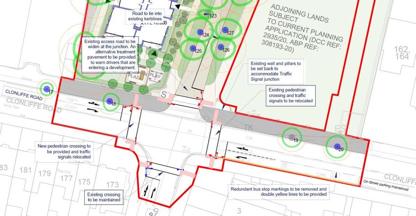
Figure 1. Site Location & Redline Boundary

1.3            Mobility Management Plan Approach
               This Mobility Management Plan (MMP) has been prepared to guide the delivery and
               management of a package of integrated initiatives which seek to encourage and embed
               sustainable travel choices by residents from the outset of the development’s occupation.

               A successfully implemented MMP can provide reductions in car usage, particularly
               influencing levels of single-occupancy car travel, with increased trips made by car-sharing,
               public transport, walking and cycling; and can improve road safety and personal security
               for pedestrians and cyclists.

               Mobility Management is about improving the development site’s access from the outset
               – by designing for and enabling and promoting sustainable travel options (e.g. walking,
               car-sharing, cycling and public transport) to residents – and by reducing the need to travel
               by car from the development in order to access essential services and amenities. MMPs
               can also improve the health and wellbeing of residents, staff and visitors through the
               benefits of active travel and reduce the transport-related carbon impact of the
               development. An MMP specifically focuses on journeys made from a single origin (home)
               to multiple destinations.

Holy Cross College SHD
Mobility Management Plan                       30060314
For Planning                                   11/05/2021                                        Page 8/65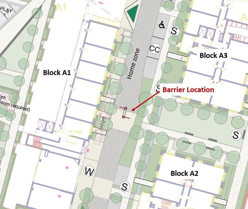
1.4 Report Structure
Following this first introductory section, the report will be set out in the following
structure:
Section 2: An introduction to Mobility Management
Section 3: Proposed development
Section 4: Policy context
Section 5: Baseline site transport review
Section 6: Pre–occupation baseline mode share
Section 7: MMP objectives and targets
Section 8: MMP measures
Section 9: Monitoring and review
Section 10: Summary
Holy Cross College SHD
Mobility Management Plan 30060314
For Planning 11/05/2021 Page 9/65
2. MOBILITY MANAGEMENT: CONTEXT
2.1 What is Mobility Management?
Mobility Management is a concept to promote sustainable transport and manage the
demand for car use by changing travellers’ attitudes and behaviour. Mobility
Management is about improving a site’s access, by designing for and enabling and
promoting sustainable travel options (e.g. walking, cycling and public transport) to
residents. The use of Mobility Management is well established in Ireland through the
Development Control process and the policy documents set out in Chapter 3. The process
involves key stakeholders such as the Local Authority, public transport operators, the
developer and future residents.
2.2 The Benefits of Mobility Management
Implementing a Mobility Management Plan (or Travel Plan) has the following potential
local benefits:
Promoting alternative uses to the car can result in less congestion and therefore
improves safety on local roads by promoting alternatives to the car.
Reduced highway capacity problems can enable more sustainable travel choices.
The local environment will be improved from reduced congestion, carbon
emissions, pollution and noise.
A range of travel options makes the development site attractive to potential
residents.
Increases opportunities for active healthy travel, such as walking and cycling.
Reduces demand for parking spaces, enabling land to be put to more cost-effective
or commercially beneficial use and freeing space for active travel initiatives.
Improved travel choice, quality and affordable access to services for all users.
2.3 Mobility Management Plan Objectives
The overarching objectives of the MMP are to reduce levels of private car use by
encouraging people to walk, cycle, use public transport, car share. It can also reduce the
number and length of trips undertaken / required (for example through the promotion of
internet shopping and home working, and the provision of an on-site parcel delivery
services).
The specific objective(s) of an MMP can vary depending upon the organisation, site
characteristics and specific land uses which vary with each site. Nevertheless, in the
context of a residential MMP, objectives can include:
Development Users
Address residents, staff and visitors need for sustainable access to a full range of
facilities for work, education, health, leisure, recreation and shopping.
Promote healthy lifestyles and sustainable, vibrant local communities by improving
the environment and the routes available for cycling and walking.
Holy Cross College SHD
Mobility Management Plan 30060314
For Planning 11/05/2021 Page 10/65The Local Community
Make local streets less dangerous, less noisy and less polluted and enhance the
viability of public transport
Reduce the traffic generated by the development for journeys both within the
development and on the external road network
Promote equal opportunities by offering wider travel choices
Improve personal and wider community health
Reduce air and noise pollution.
2.4 Making Residential Mobility Management Plans Work
A successful MMP will address all aspects of a development that create a need to travel
by site residents. The MMP ‘pyramid’ below demonstrates how successful plans are built
on the firm foundations of location and site design. A MMP should combine hard
measures (e.g. cycle parking, routes to bus stops) and soft measures (such as bus taster
tickets and personalised journey planning). All measures should be integrated into the
design, marketing and occupation of the site – with parking restraint often crucial to the
success of the MMP in reducing car use.1
Figure 2. The Travel Plan Pyramid
MMPs are evolutionary documents that should be regularly updated. In this way, MMP
targets and Action Plans can be reviewed and tailored to take account of ongoing changes
in travel patterns. It is therefore intended that this MMP is the starting point of a live
process and will be updated on an annual basis or when required by other circumstances.
MMP specific objectives should be ‘SMART’ (Specific, Measurable, Achievable, Realistic
and Time-Bound).
1 UK Department for Transport Making Residential Travel Plans Work – June 2007
Holy Cross College SHD
Mobility Management Plan 30060314
For Planning 11/05/2021 Page 11/653. CURRENT TRANSPORT POLICY, PLANS AND STRATEGY
REVIEW
This section provides an overview of the national, regional and local transport and other
policy drivers and strategies that underpin the requirements (and benefits) of
implementing a Mobility Management Plan for the proposed residential development.
Please also see the accompanying Transport Assessment for a more detailed overview of
current transport policy, plans and strategies of relevance to the site.
3.2 National Policy Context
This section provides an overview of the main national policy drivers and strategies that
underpin the requirements (and benefits) of implementing a Residential MMP for the
residential development proposed at the Clonliffe Lands site.
Ireland 2040 Our Plan – National Planning Framework
The Project Ireland 2040 - National Planning Framework (NPF) recognises that
improvements in connectivity are achievable and are necessary to boost both
competitiveness and quality of life. The Ireland 2040 Vision includes the following key
elements which have direct relevance to Mobility Management.
1. More sustainable choices and options for people, businesses and communities
that can positively influence sustainable patterns of living and working.
2. The highest possible quality of life for our people and communities, underpinned
by high quality, well managed built and natural environments.
3. Significant improvement in local and international connectivity that underpins the
competitiveness and quality of life of our people, businesses, communities and
regions.
The NPF has been developed to deliver the following National Strategic Outcomes (as part
of the Smart Growth Urban Initiative to achieve sustainable growth) which are pertinent
to this report. These are to:
Improve accessibility to and between centres of mass and scale and provide better
integration with their surrounding areas.
Ensure transition to more sustainable modes of travel (walking, cycling, public
transport) and energy consumption (efficiency, renewables) within an urban
context.
The NPF seeks to enable people to live closer to where they work, moving away from the
current unsustainable trends of increased commuting. It supports more energy efficient
development through the location of housing and employment along public transport
corridors, where people can choose to use less energy intensive public transport, rather
than being dependent on the car.
The Eastern and Midland Regional Assembly (EMRA), through its “Regional Spatial and
Economic Strategy”, also supports travel planning. Specifically, through Regional Policy
Objective (RPO) 8.7 which promotes the use of mobility management and travel plans to
bring about behaviour change and more sustainable transport use.
Holy Cross College SHD
Mobility Management Plan 30060314
For Planning 11/05/2021 Page 12/65Regarding the proposed development at the Clonliffe, the following aims and objectives
from the NPF are applicable:
National Policy Objective 10b: Regional and Local Authorities to identify and
quantify locations for strategic employment development, where suitable, in urban
and rural areas generally.
National Policy Objective 11: In urban areas, planning and related standards,
including building height and car parking will be based on performance criteria
enabling alternative solutions that seek to achieve well-designed high quality and
safe outcomes in order to achieve targeted growth and that protect the
environment.
National Policy Objective 28: Ensure the integration of safe and convenient
alternatives to the car into the design of our communities, by integrating physical
activity facilities for all ages, particularly prioritising walking and cycling accessibility
to both existing and proposed future development, in all settlements.
National Policy Objective 35: Increase residential density in settlements, through a
range of measures including reductions in vacancy, re-use of existing buildings, infill
development schemes, area or site-based regeneration and increased building
heights.
National Policy Objective 61: To improve air quality and help prevent people being
exposed to unacceptable levels of pollution in our urban and rural areas through
integrated land use and spatial planning that supports public transport, walking and
cycling as more favourable modes of transport to the private car.
Sustainable Urban Housing: Design Standards for New Apartments: Guidelines for Planning Authorities
The ‘Sustainable Urban Housing: Design Standards for New Apartments – Guidelines for
Planning Authorities’ was published by the Department of Housing, Planning and Local
Government in March 2018. The document provides direction for local authorities taking
account of the current and future need for housing in line with the National Planning
Framework (NPF) and Project Ireland 2040. The document outlines a number of Specific
Planning Policy Requirements (SPPRs) which planning authorities and An Bórd Pleanála
are required to apply in carrying out their functions.
Based on the NPF projections there is a need to build 550,000 new households nationally
by 2040 to accommodate a 1 million person increase in population. The objective is for
these new households to be located in as sustainable a location as possible within our
towns and cities to address increasing pollution and commuting times and enable the
state to feasibly provide and justify supporting infrastructure.
For large scale, higher density residential developments located within an accessible
urban location the guidelines state that “the default policy is for car parking provision to
be minimised, substantially reduced or wholly eliminated in certain circumstances.” This
policy is particularly applicable in highly accessible areas at a confluence of public
transport systems such rail and bus stations located in close proximity.
The criteria for these locations is to be within a 15-minute walk of the city centre, 10-
minute walk to rail or tram or 5-minute walk to high frequency (10min peak hour
frequency) bus services.
In suburban/urban locations served by public transport or close to city/town centres or
employment areas and particularly for high density schemes, the guidance states that
Holy Cross College SHD
Mobility Management Plan 30060314
For Planning 11/05/2021 Page 13/65planning authorities must consider a reduced overall car parking standard and apply an
appropriate maximum car parking standard.
With respect to mobility management, the guidance goes on to state:
“As well as showing that a site is sufficiently well located in relation to employment,
amenities and services, it is important that access to a car sharing club or other non-car
based modes of transport are available and/or can be provided to meet the needs of
residents, whether as part of the proposed development, or otherwise”.
Smarter Travel, A Sustainable Transport Future (STASTF) – A New Transport Policy for Ireland, 2009-2020
As recognised in Smarter Travel, A Sustainable Transport Future – A New Transport Policy
for Ireland 2009 – 2020 there is a need to provide an integrated transport network that
enables the efficient, effective and sustainable movement of people and goods, in order
to contribute to economic, social and cultural progress.
This policy recognises that without intervention, congestion will get worse, transport
emissions will continue to grow, economic competitiveness will suffer, and quality of life
will decline. The key goals are as follows:
Improve quality of life and accessibility to transport for all and for people with
reduced mobility and those who may experience isolation due to lack of transport.
Improve economic competitiveness through maximising the efficiency of the
transport system and alleviating congestion and infrastructural bottlenecks.
Minimise the negative impacts of transport on the local and global environment
through reducing localised air pollutants and greenhouse gas emissions.
Reduce overall travel demand and commuting distances travelled by the private
car.
Improve security of energy supply by reducing dependency on imported fossil fuels.
The implementation of STASTF will also assist in meeting Ireland's international
obligations towards tackling climate change. The following actions are relevant to the
proposed residential development at the Clonliffe Lands site:
Action 1 – We will continue to enhance existing legislative provisions to deliver deeper
integration of travel and spatial planning and to support the full integration and alignment
of transport plans with the development plan process and local area planning (see also
Action 42).
Action 2 – We will ensure better integration of land use planning and transport policies in
the relevant planning guidelines as part of their ongoing review and we will avail of policy
directives to give effect to specific measures needed to meet the vision for sustainable
travel. The following will also be included in future planning guidelines: a requirement
that developments above a certain scale have viable travel plans in place. The following
will also be included in future planning guidelines:
A general requirement that significant housing development in all cities and towns
must have good public transport connections and safe routes for walking and
cycling to access such connections and local amenities.
Integration of cycling and public transport.
Holy Cross College SHD
Mobility Management Plan 30060314
For Planning 11/05/2021 Page 14/65 A requirement that developments above a certain scale have viable travel plans in
place
The National Cycle Manual
The National Cycling Manual is focused on encouraging more people to cycle and
providing for cycling in a stress free and safe environment. The Manual embraces the
Principles of Sustainable Safety to offer a safe traffic environment for all road users
including cyclists and offers guidance on integrating the bike in the design of urban areas.
It challenges planners and engineers to incorporate cycling within transport networks
more proactively than before.
Get Ireland Active – The National Physical Activity Plan, 2016
Another key policy driver for the encouragement of active, healthy commuting trips is the
Get Ireland Active – National Physical Activity Plan (NPAP). Launched in 2016, this plan
recognises that physical inactivity is a demonstrated clear risk to health and wellbeing in
Ireland.
The NPAP is about creating increased opportunities for people to be active in ways which
fit in to their everyday lives and which suits individual needs, circumstances and interests,
and to remove the barriers which people face to being active – by encouraging a
supportive environment where physical activity becomes normal.
The NPAP focuses on the use of the natural and built environment. It recognises that
promoting active transport are the most practical and sustainable ways to increase
physical activity as part of people’s everyday routine. It specifically identifies the role of
walking or cycling for utility transport as a means to increase people’s physical activity
levels.
3.3 Regional and Local Policy Context
This section provides an overview of the main regional and local policy drivers and
strategies that underpin the context, requirements and benefits of a Mobility
Management Plan for the proposed residential development.
Greater Dublin Area Transport Strategy, 2016-2023
This strategy aims to contribute to the economic, social and cultural progress of the
Greater Dublin Area by providing for the efficient, effective and sustainable movement of
people and goods – helping to reduce modal share of car-based commuting to a maximum
of 45%. To achieve these principles, future developments must:
Have transport as a key consideration in land use planning – integration of land use
and transport to reduce the need to travel, reduce the distance travelled, reduce
the time taken to travel, promote walking and cycling especially within
development plans.
Protect the capacity of the strategic road network.
Holy Cross College SHD
Mobility Management Plan 30060314
For Planning 11/05/2021 Page 15/65 Ensure a significant reduction in share of trips taken by car, especially those trips
which are shorter or commuter trips.
Take into account all day travel demand from all groups.
Provide alternate transport modes in order to reduce the strain on the M50 as
current increase in traffic is unsustainable.
The site is within walking distance of improved public transport provisions such as the
proposed BusConnects Core Bus Corridor(s), which will enhance the overall public
transport provision across urban Dublin. This will improve public transport options for
residents, including for those commuting to destinations across the wider Dublin area.
Dublin City Council Development Plan, 2016-2022
The Dublin City Development Plan provides a coherent, integrated framework to ensure
the city develops in an inclusive and sustainable manner which is resilient on social,
economic and environmental fronts in the short and longer term. The plan emphasises
the need for Dublin to become a low-carbon city and the role of compact, self-sustaining
communities and neighbourhoods, urban form and movement has to play in achieving
this goal.
The plan details a Core Strategy which includes housing, settlement, employment, retail
and public transport strategies. The strategy translates into 3 broad strands which form
the basis for the policies and objectives outlined in the plan, these are:
Compact, Quality, Green, Connected City;
A Prosperous, Enterprising, Creative City; and
Creating Sustainable Neighbourhoods and Communities.
The policies and objectives of the plan are categorised into 12 broad areas. Table 1 below
provides a summary of the policies most relevant to this MMP.
Table 1. Extracts from most relevant Dublin City Development Plan 2016-2022 Policies
No. Details
“To promote the development of a network of active, attractive and safe streets and public
spaces….which encourage walking as the preferred means of movement between buildings
SC19
and activities in the city. In the case of pedestrian movement within major developments, the
creation of a public street is preferable to an enclosed arcade or other passageway.”
“To promote the development of high-quality streets and public spaces which are accessible
SC20 and inclusive, and which deliver vibrant, attractive, accessible and safe spaces and meet the
needs of the city’s diverse communities. “
“To support the creation of a permeable, connected and well-linked city and discourage gated
QH10
residential developments as they exclude and divide established communities.”
“Whilst having regard to the necessity for private car usage to continue to promote modal shift
MT2 from private car use towards increased use of more sustainable forms of transport such as
cycling, walking and public transport...”
“To improve the city’s environment for walking and cycling through the implementation of
MT7 improvements to thoroughfares and junctions and also through the development of new and
safe route..”
“To provide 30kph speed limits and traffic calmed areas at appropriate locations throughout
MT10
the city subject to stakeholder consultation.”
“To continue to promote improved permeability for both cyclists and pedestrians in existing
MT11
urban areas...”
“To improve the pedestrian environment and promote the development of a network of
MT12 pedestrian routes which link residential areas with recreational, educational and employment
destinations to create a pedestrian environment that is safe and accessible to all.”
Holy Cross College SHD
Mobility Management Plan 30060314
For Planning 11/05/2021 Page 16/65“To promote bets practice mobility management and travel planning to balance car use to
MT13
capacity and provide necessary mobility via sustainable transport modes.”
“To provide sustainable levels of car parking and storage in residential schemes in accordance
MT17 with development plan car parking standards so as to promote city centre living and reduce
the requirement for car parking.”
“To encourage new ways of addressing the paring needs of residents (such as car clubs) to
MT18
reduce the requirement for car parking.”
“To support the growth of Electric Vehicles and e-bikes, with support facilities as an alternative
MTO25 to the use of fossil-fuel-burning vehicles, through a roll-out of additional electric charging
points in collaboration with relevant agencies at appropriate locations.“
Section 16.38 & 16.39 set out the car and cycle parking standards respectively. The plan
states that car parking standards are maximum in nature and may be reduced where other
modes of transport provide sufficient mobility for users of the development. Alternative
solutions will also be considered such as residential car clubs where there are site
constraints.
Holy Cross College SHD
Mobility Management Plan 30060314
For Planning 11/05/2021 Page 17/654. PROPOSED DEVELOPMENT
4.1 Proposed Development
4.1.1 Development Description:
The development will consist of the construction of a Build To Rent residential
development set out in 12 no. blocks, ranging in height from 2 to 18 storeys, to
accommodate 1614 no. apartments including a retail unit, a café unit, a crèche, and
residential tenant amenity spaces. The development will include a single level
basement under Blocks B2, B3 & C1, a single level basement under Block D2 and a
podium level and single level basement under Block A1 to accommodate car
parking spaces, bicycle parking, storage, services and plant areas. To facilitate the
proposed development the scheme will involve the demolition of a number of
existing structures on the site.
The proposed development sits as part of a wider Site Masterplan for the entire
Holy Cross College lands which includes a permitted hotel development and future
proposed GAA pitches and clubhouse.
The site contains a number of Protected Structures including The Seminary
Building, Holy Cross Chapel, South Link Building, The Assembly Hall and The
Ambulatory. The application proposes the renovation and extension of the
Seminary Building to accommodate residential units and the renovation of the
existing Holy Cross Chapel and Assembly Hall buildings for use as residential tenant
amenity. The wider Holy Cross College lands also includes Protected Structures
including The Red House and the Archbishop’s House (no works are proposed to
these Structures).
The residential buildings are arranged around a number of proposed public open
spaces and routes throughout the site with extensive landscaping and tree planting
proposed. Communal amenity spaces will be located adjacent to residential
buildings and at roof level throughout the scheme. To facilitate the proposed
development the scheme will involve the removal of some existing trees on the
site.
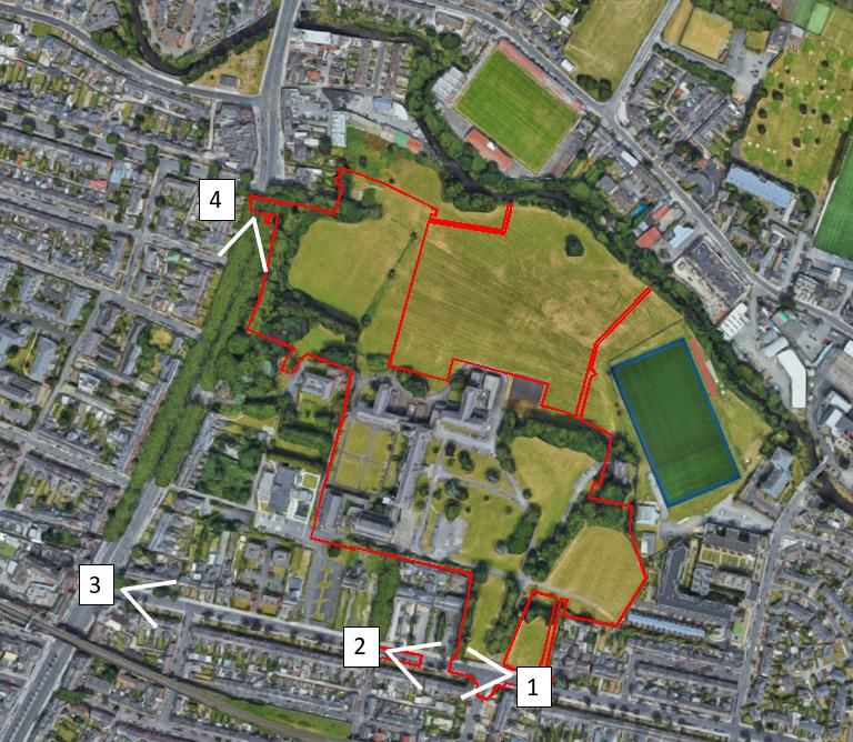
The site is proposed to be accessed by vehicles, cyclists and pedestrians from a
widened entrance on Clonliffe Road, at the junction with Jones’s Road and through
the opening up of an unused access point on Drumcondra Road Lower at the
junction with Hollybank Rd. An additional cyclist and pedestrian access is proposed
through an existing access point on Holy Cross Avenue. Access from the Clonliffe
Road entrance will also facilitate vehicular access to future proposed GAA pitches
and clubhouse to the north of the site and to a permitted hotel on Clonliffe Road.
The proposed application includes all site landscaping works, green roofs, boundary
treatments, PV panels at roof level, ESB Substations, lighting, servicing and utilities,
signage, and associated and ancillary works, including site development works
above and below ground.
In addition, the following land uses are proposed within the overall Masterplan site and
will be subject to separate planning applications:
Holy Cross College SHD
Mobility Management Plan 30060314
For Planning 11/05/2021 Page 18/65 Approximately 1500m2 recreational use sport pitches with a clubhouse (subject to
future planning application); and
A 200 bedroom hotel (permitted under DCC Reg. Ref.: 2935/20, ABP Reg. Ref.:
PL29N.30819)
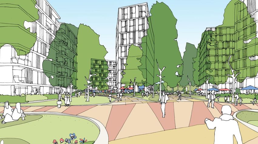
Figure 3. Proposed Development: Block Layout & Site Functions
4.2 Pedestrian & Cycle Access and Circulation
The Design Manual for Urban Roads & Streets (DMURS) indicate a hierarchy of travel
modes with walking being the highest and most sustainable form of travel. Walking will
not reduce long distance trips, however encouraging walking will reduce short distance
vehicle trips, provide linkage to public transport and as an added benefit, will improve
health and fitness.
There is a well-established network of footways throughout the surrounding area that
provide strong connections between the proposed development and key local facilities /
amenities. This is discussed further in Section 5.
The internal network of the proposed development has been designed to prioritise
sustainable transport modes, while allowing for required vehicular access to car parking
and for service vehicles. Not only will it seek to provide a safe and permeable
environment for residents of the proposed development, it will also aim to provide a safe
and direct link between the site and the external pedestrian and cycling networks and a
future link to the full masterplan area.
Pedestrian and cyclists access points into the site from the local network will be provided
from the following points:
Clonliffe Road at the existing access into the site at the junction with Jones’s Road
(southern edge of site);
Clonliffe Road at Holycross Avenue (southern edge of site); and
Holy Cross College SHD
Mobility Management Plan 30060314
For Planning 11/05/2021 Page 19/65 Drumcondra Road at the junction with Hollybank Road (western edge of the site);
The access strategy for pedestrians and cyclists is shown in Figure 4 and has been designed
to deliver a high level of permeability for active travel modes, comprising the following
three types of routes:
Primary: the entire internal road network will be traffic calmed with a 30kph
maximum speed limit so that it will not be an attractive ‘rat-run’ or quicker
alternative to the main roads;
Secondary: the design of secondary routes will be more integrated and have a high
pedestrian/cycle priority with shared surfaces/home-zones used where possible.
They are also designed to tie into the pedestrian/cyclist only access points to the
site. Vehicular traffic along these routes will be minimal; and
Shared Space: a design concept which gives equal priority or equal rights of road
space to cars, pedestrians and cyclists. The aim is to reduce the dominance of cars
and car speeds through the design of the road space, whilst increase pedestrian
and cyclist priority.
The routes through the site will be delivered as shared streets and mature tree-lined
paths, interwoven with footpaths and green links, to ensure a pleasant and safe
environment for walking and cycling. It will not be possible for car traffic to cut through
the development from Drumcondra Road to Clonliffe Road to ensure streets are as calm
as possible.
As outlined in Figure 3, the overall masterplan access strategy includes a potential cycling
friendly north to south green corridor linking Holycross Avenue to Richmond Road in line
with the GDA Cycle Network Plan. This access point is not subject to this application and
will be developed further by Dublin City Council as part of the development lands north
of the River Tolka.
Holy Cross College SHD
Mobility Management Plan 30060314
For Planning 11/05/2021 Page 20/65Figure 4. Pedestrian & Cyclists Access Strategy
Cycle Parking
The site is within DCC Parking Zone 2 and the standards stipulate that the development
should provide a minimum of one cycle parking space per residential unit. The Design
Standards for New Apartments suggest a higher level of cycle parking should be provided
for residential uses than 1 per unit, and instead advocate the provision of one space per
bedroom. However, it has been agreed with DCC that cycle parking for the apartments
will be provided at 1.3 cycle spaces per unit. This is above the recommended level as per
DCC’s guidelines on account of the low car parking numbers and to accentuate the
sustainable vision for the site.
The DCC parking standards per land use and the level of provision proposed is indicated
by Table 2.
Table 2. DCC and DSFNA Cycle Parking Standards & Provision
Land Use DCC Standards DSFNA Standards DCC agreed ratio
Minimum 1 per
Residential 1 per bedroom (2,139) 1.3 per unit (2,098)
unit (1,614)
Total Provision 2,255 Long Stay Secure
As Table 2 demonstrates, the proposed development will provide above the DCC
requirement for cycle parking, the DSFNA requirements and the agreed minimum ratio of
1.3 per unit (2,098). This over provision will be allocated for non-residential elements of
Holy Cross College SHD
Mobility Management Plan 30060314
For Planning 11/05/2021 Page 21/65the development, for instance staff working on the creche, retail, concierge, café and
other potential uses.
Staff working on the retail and creche in Block A4 will have access to long stay secure
parking on the Bike Shed. Staff working on D1 café and Concierge will have allocated long
stay secure parking in the Central Basement.
In addition to the long stay spaces, a further 252 short stay spaces will be provided around
site for visitors to the development. These will be provided in the form of Sheffield Stands.
This will bring the total number of cycle spaces to 2,507 for the residential portion of the
masterplan, the basis of this application.
The long stay cycle parking will be two tier stacked parking, an example of which is shown
in Figure 5. The ceiling heights and aisle widths of the bike room have all been designed
to accommodate the dimensions illustrated. For buildings where a basement is present,
cycle parking will be located underneath residential blocks and cycle lifts will be installed
to aid access. Where no basement is present, cycle parking will be provided in secure
rooms or covered sheds close to the building entrance. Table 3 shows the allocation of
bike parking for each blocks for residential uses, and other uses.
Table 3. Bike Parking Allocation
Blocks Bike Parking Allocation
BLOCK A1 A1 Basement and A1 Podium
BLOCK A2 A2 Store
BLOCK A3 A2 Store
BLOCK A4 A1 Podium and A4 Shed Store
BLOCK B1 B1 Store
BLOCK B2 Central Basement: bike room B2 & B3 combined
BLOCK B3 Central Basement: bike room B2 & B3 combined
BLOCK C1 Central Basement: bike room C1 & C2 combined
BLOCK C2 Central Basement: bike room C1 & C2 combined and C2 Shed Store
BLOCK D1 Central Basement: bike room D1
BLOCK D2 D2 Basement
BLOCKS E1 / E2 E1/E2 bike store
Creche and Retail E1/E2 bike store
Café and Concierge Shed Store
Holy Cross College SHD
Mobility Management Plan 30060314
For Planning 11/05/2021 Page 22/65Figure 5. Two-Tier Cycle Parking with dimensions
4.3 Vehicular Access & Circulation
Vehicular access to the proposed development from the local road network will be
provided from the following two points:
Primary access: from Clonliffe Road via an upgraded 4-arm signalised crossroads
junction between Clonliffe Road, Jones’s Road and the Proposed Development. It
is anticipated that the majority of vehicles to the development will utilise this
access; and
Secondary access: from Drumcondra Road Lower via a new left-in/left-out
arrangement creating a 4-arm priority crossroads junction between Drumcondra
Holy Cross College SHD
Mobility Management Plan 30060314
For Planning 11/05/2021 Page 23/65Road, Hollybank Road and the proposed development. Only a small proportion of
vehicles will utilise this access to reach the residential element of the development
(discussed further in Section 7 of the TA).
The secondary access from Drumcondra Road will be for car park/delivery/creche/retail
and servicing/emergency access only site only. The primary access from Clonliffe Road will
provide access into all vehicular-designated areas of the site.
Circulation through the site has been designed so that it will not be possible for car traffic
to cut through the development between Drumcondra Road and Clonliffe Road to avoid
creating a “rat run”. A barrier system will be installed within a ‘home-zone’ between
blocks A1 and A2. This will serve the dual purpose of calming traffic and controlling
through movements. The proposed location of the barrier is shown in Figure 6.
Figure 6. Barrier Location
The aforementioned vehicular access points and circulation routes are demonstrated in
Figure 7.
Holy Cross College SHD
Mobility Management Plan 30060314
For Planning 11/05/2021 Page 24/65Figure 7. Vehicular Access Strategy
It should be noted that the access requirements for the hotel and GAA pitches/clubhouse
are accommodated as part of the overall Masterplan development but the plans are
subject to individual planning applications. The hotel has been permitted under DCC Reg.
Ref.: 2935/20, ABP Reg. Ref.: PL29N.30819.
4.4 Network Improvements
A number of infrastructural measures are proposed to improve access for all modes to
the site and limit the impact of any additional demand on the immediate network. As
discussed, two new vehicular access junctions (from Clonliffe Road and Drumcondra Road
respectively) will be provided as well as three designated pedestrian and cyclists access
points.
To facilitate these access points, the following upgrades to the network will be made (as
shown in Figure 8 below):
Upgraded 4-arm signalised junction on Clonliffe Road at the primary development
access;
New left-in/left-out priority junction with Drumcondra Road; and
Enhanced pedestrian crossing point on Clonliffe Road at Holycross Avenue
which will provide an upgraded pedestrian and cyclists access into the
development.
Holy Cross College SHD
Mobility Management Plan 30060314
For Planning 11/05/2021 Page 25/65Figure 8. Overview of External Network Improvements
Upgraded Access Junction from Clonliffe Road
The current signalised junction between Clonliffe Road and Jones’s Road will be upgraded
to accommodate the development access arm into a 4-arm signalised junction. The
existing kerb lines will be maintained, however, pedestrian crossings will be provided on
all arms of the junction (currently no crossing is provided on the Clonliffe Road West arm).
The key features of the junction improvement can be seen in Error! Reference source not f
ound..
Figure 9. Clonliffe Road / Primary Development Access / Jones’s Road Upgraded Junction
Holy Cross College SHD
Mobility Management Plan 30060314
For Planning 11/05/2021 Page 26/65New Access Junction from Drumcondra Road
Currently there is a gated dropped kerb access from Drumcondra Road but it is unused
and there are no road markings. The proposed development will create a new priority
controlled access junction here comprising and left-turn in and out only arrangement
from Lower Drumcondra Road. This will ensure a minimal amount of disruption to the
operation of this current 3-arm priority junction with Hollybank Road. ‘Turn Left’ signage
will be erected at the site exit and ‘No Right Turn’ signage on Drumcondra Road Lower
northbound.
The access will incorporate the Bus Connects proposed improvements by providing a
break in the mandatory cycle lane to create a small section of advisory lane which will
allow vehicles to turn across the cycle lane. The stop line for the site exit will be behind
the cycle lane. The key features of this junction can be seen in Error! Reference source n
ot found..
Holy Cross College SHD
Mobility Management Plan 30060314
For Planning 11/05/2021 Page 27/65Figure 10. Future Drumcondra Road / Secondary Development Access New Junction under BusConnects
Enhanced Pedestrian Crossing on Clonliffe Road
The current crossing at this location on Clonliffe Road (adjacent to Holycross Avenue)
comprises a dropped kerb and narrow pedestrian refuge island in the centre of the two
traffic lanes. The proposed development will upgrade this crossing to provide tactile
paving with the dropped kerbs.
Visibility is currently poor due to parked cars, therefore, the footpath will be built-out on
the southern side to improve visibility and pedestrian safety. The pedestrian refuge island
will be removed as the build-out will make the length of the crossing narrower for
pedestrians and to make the road more conducive to cyclists. This will also facilitate left-
turning vehicles from Mabel Street.
The key features of this enhanced crossing can be seen in Figure 11.
Figure 11. Enhanced Pedestrian Crossing on Clonliffe Road
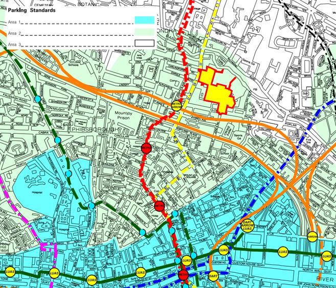
4.5 Car Parking
Dublin City is divided into three parking zones in the Council Development Plan 2016-2022
and proposed development site is located within the area designated as Parking Zone 2,
as shown in Figure 12.
The plan advises that car parking provision in Zones 1 and 2 should be restricted on
account of these locations being close to good public transport. This is in line with 2018
government guidance that states car parking provision should be minimised, substantially
reduced or wholly eliminated in accessible urban areas. The maximum parking quantities
for Zone 2 are demonstrated in Table 4.
Holy Cross College SHD
Mobility Management Plan 30060314
For Planning 11/05/2021 Page 28/65Figure 12. DCC Parking Zones
Table 4. DCC Maximum Parking Standards for Zone 2
Type Residential Comments
Each space permanently assigned to & sold with each
Maximum 1 per
Car Parking apartment & not sublet/ leased to non-residential
residential unit
owners/ occupiers
Unspecified but in
Electric
line with national -
Vehicles
policy/targets
5% of total car park
Disabled -
spaces
Where sites are constrained… alternative solutions will
Car Club No Set Guidance
be considered e.g. car clubs
Considering recent national policy, the predicted mode share of the development, the low
car ownership levels locally, the location of the site adjacent to alternative modes (quality
bus corridor, rail, cycle infrastructure), and the proposed on-site mobility services; it is
considered appropriate to provide a car parking ratio of 0.3 car spaces per unit to serve
the proposed development. Alongside this, a residential cycle parking ratio of 1.3 cycle
spaces per unit is proposed, this is well above the minimum of 1 cycle space per unit set
out in the parking standards to account for the lower number of car parking spaces.
Holy Cross College SHD
Mobility Management Plan 30060314
For Planning 11/05/2021 Page 29/65Table 5. DCC Car Parking Standards & Provision
Land Use Standard Requirement Provision
0.3 car parking spaces per unit to be provided
Residential Max 1 per unit Max 1,614
(484no. to be provided)
Total 484 Residential Car Parking Spaces
As Table 5 indicates, the proposed development will provide 484 residential car parking
spaces which is below the DDC maximum for car parking, with an approximate ratio of 0.3
per unit.
477no. of residential car parking spaces will be located at podium or basement level to
improve the visual appeal of the site and prevent a car dominated landscape. In addition,
7 spaces will be provided at surface level for mobility impaired residents who don’t have
direct access to basements. That makes a total of 484 residential car parking spaces.
At surface level 31no. of spaces will be provided. Of these:
7no. of these spaces will be for use by mobility impaired residents (as outlined
above). This will ensure there is a suitable designated parking space with direct
access to blocks without direct access to a basement.
4no. of these spaces will be for use by mobility impaired visitors to the site;
16 of these spaces will be used as pay and display; and
4 of these spaces will be designated exclusively for car club use.
7 loading bays will be provided along the site to serve the blocks and provide a set-
down/pick-up facility;
A total of 5% of spaces will be reserved for those with mobility impairments. Electric
charging points will also be installed for 10% of spaces with the remainder future proofed
for 100% installation.
4.5.8 A summary of the basement car parking for this application is provided in Table 6.
Table 6. Development Car Parking Provision
Standard
Total Mobility EV Car Car Club
CAR PARKING Resi
Spaces Parking Parking Parking
Spaces
Central Basement 158 128 8 16 6
D2 Basement 86 70 4 9 3
A1 Podium 89 72 4 9 4
A1 Basement 144 116 7 14 7
Total for this application 477 386 23 48 20
4.5.9 A summary of the overall surface car parking is provided in Table 67.
Table 7. Development Car Parking Provision
Mobility
Total Parking EV Car Car Club Standard
CAR PARKING Loading
Spaces Residents Parking Parking spaces
/ Visitors
Surface 31 11 3 4 13 7
Holy Cross College SHD
Mobility Management Plan 30060314
For Planning 11/05/2021 Page 30/655. BASELINE TRANSPORT REVIEW
5.1 Overview
A review of the existing transport network was undertaken to inform the Transport
Assessment. The review focused on all modes of transport:
Active Modes – e.g. cycling and walking;
Existing Public Transport Modes – e.g. bus, rail and light rail;
Existing road network;
Overview of the existing transport demand in the surrounding area.
5.2 The Site and Surrounding Land Use
The Masterplan lands are situated immediately east of Drumcondra Road and bounded
by Clonliffe Road to the South and the Tolka River to the North. The site is less than 2km
from Dublin City Centre and there are several public transport options nearby that enable
sustainable travel across the Greater Dublin Area.
The land use of the surrounding area is predominantly residential with some commercial
areas located along Drumcondra Road Lower. Croke Park, the national Gaelic games
stadium and headquarters of the Gaelic Athletic Association (GAA), is located just to the
south.
As indicated in Figure 13, the Clonliffe Lands are situated to the immediate east of
Drumcondra Road and bounded by Clonliffe Road to the South and the Tolka River to the
North. The development is very well served by public bus and it is located in close
proximity to the Swords Quality Bus Corridor which runs directly to the City Centre along
the N1. Drumcondra Rail Station is just a short walk from the site.
Figure 13. Site Location
Holy Cross College SHD
Mobility Management Plan 30060314
For Planning 11/05/2021 Page 31/655.3 Walking Provision
The main pedestrian routes to and from the site are generally of very good quality with
wide footpaths and street lighting. The pedestrian and cycle entrance along Holycross
Avenue has limited street lighting which may need to be addressed as part of the
proposed development.
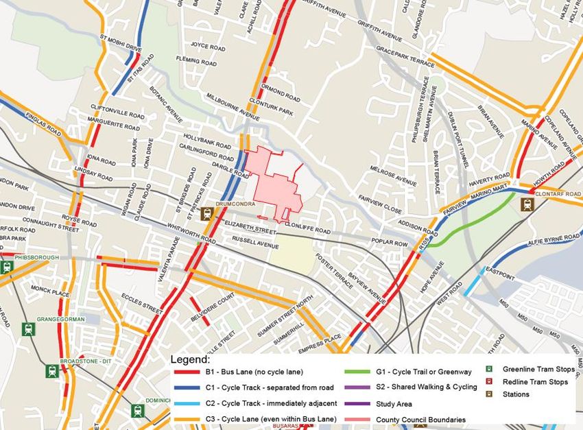
Clonliffe Road has footpaths on both sides of the road of approximately 3.5m wide on the
northern side and 2m on the southern side. There is a signalised pedestrian crossing at
the junction with Jones’s Road comprising dropped kerbs and tactile paving immediate
east of one of the access points into the site. These characteristics are shown in Figure 15.
There is also a narrow pedestrian refuge island at Holycross Avenue just south of the
development along Clonliffe Road with dropped kerbs but there is no formal road
markings or signage, as shown in Figure 16. Visibility can be poor due to parked cars. This
may need to be improved to facilitate better pedestrian safety as Holycross Avenue will
be one of the primary pedestrian and cycle entrances to the site.
At the 3-arm signalised junction between Clonliffe Road and Drumcondra Road, there are
signalised pedestrian crossings with dropped kerbs and tactile paving at the Clonliffe Road
and Drumcondra Road North arms (the latter comprises a staggered crossing with guard
rails), as shown in Figure 17.
Drumcondra Road has footpaths on both sides of the road varying from approximately
2m – 3m wide. Between St Alphonsus’ Road Lower and Hollybank Road, the footpath is
segregated from the carriageway by railings and a 2m grass verge, as shown in Figure 18.
The footpath runs alongside an off-road cycle track, delineated by white lining.
Figure 14 indicates viewpoints at which Figure 15 – Figure 18 are demonstrating the
characteristics of the pedestrian environment.
Holy Cross College SHD
Mobility Management Plan 30060314
For Planning 11/05/2021 Page 32/65Figure 14. Pedestrian Environment - Overview
Figure 15. Pedestrian Environment – Viewpoint 1
Holy Cross College SHD
Mobility Management Plan 30060314
For Planning 11/05/2021 Page 33/65Figure 16. Pedestrian Environment – Viewpoint 2
Figure 17. Pedestrian Environment – Viewpoint 3
Holy Cross College SHD
Mobility Management Plan 30060314
For Planning 11/05/2021 Page 34/65Figure 18. Pedestrian Environment – Viewpoint 4
The site is within a convenient walking distance of the city centre and a number of other
large employment centres as well as leisure and retail facilities. The Mater and Rotunda
Hospitals are within 20-minute walk of the site as is Phibsborough and the city centre.
Figure 19 outlines the 20 and 30-minute walking catchment and 15-minute cycle
catchment of the site.
Holy Cross College SHD
Mobility Management Plan 30060314
For Planning 11/05/2021 Page 35/65Figure 19. Walking & Cycling Catchment Holy Cross College SHD Mobility Management Plan 30060314 For Planning 11/05/2021 Page 36/65
There are many local creches, schools, convenience shops and supermarkets, sports and
youth clubs and parks, community gardens and a range of other local amenities within
easy walking distance of the site. The local amenities within a 20-minute walking
catchment are shown in Figure 20.
Figure 20. Local Catchment & Amenities
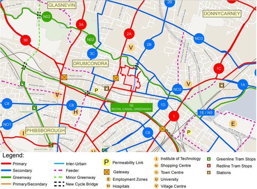
5.4 Cycling Provision
As Figure 19 above demonstrates, the site is situated within a convenient 15 minute
cycling distance of a large area of Central and North Dublin and employment hubs,
including the city centre.
Two-way off-road cycle tracks run between Hollybank Road and St Alphonsus’ Avenue
alongside the western periphery of the site. However, cycle lane infrastructure elsewhere
in the surrounding area is currently limited, and there are currently no cycle lanes along
Clonliffe Road or Jones’s Road. The current level of cycling provision is demonstrated in
Figure 21.
Holy Cross College SHD
Mobility Management Plan 30060314
For Planning 11/05/2021 Page 37/65(Source: National Transport Authority)
Figure 21. Existing Cycle Lane Provision
There are various ‘Sheffield’-style cycle stands at points on the footpaths surrounding the
site. These include:
Along Clonliffe Road immediately west of the Jones’s Road junction (five stands, as
demonstrated by Figure 22);
On the western side of Drumcondra Road at the junction with Clonliffe Road (five
stands); and
At three points at the junction between Drumcondra Road and Hollybank Road
(approximately nine stands in total).
Figure 22. Cycle Stands on Clonliffe Road
Holy Cross College SHD
Mobility Management Plan 30060314
For Planning 11/05/2021 Page 38/65You can also read