Apollo Bay Structure Plan Volume 2 - Background and Analysis - Colac Otway Shire
←
→
Page content transcription
If your browser does not render page correctly, please read the page content below

Apollo Bay
Structure Plan
     Volume 2

      Background and Analysis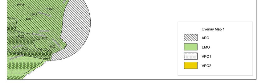
Contents

1.    Community Feedback ......................................................................................... 2
2.    Strategic Context............................................................................................... 17
3.    Demographics and Development Trends ......................................................... 32
Appendix A – Existing Planning Scheme Zone Map ................................................. 40
Appendix B – Existing Planning Scheme Overlay Maps ........................................... 41

                                                                                                                       1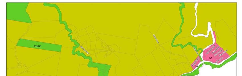
1. Community Feedback
   This section provides a summary of all the community feedback received both before
   and during the preparation of the Draft Structure Plan (Consultation A), and in
   response to the draft Structure Plan (Consultation B), through the various methods
   outlined in Volume 1.

   Consultation A:
   Community Workshop 1
   Stage 1 of the Community Consultation process comprised two workshops, with one
   held in Apollo Bay on 26 September, attended by approximately 47 people, and a
   second workshop held in Melbourne on 6 October 2005, attended by approximately
   35-40 people. The workshops were structured around 5 key questions, which
   highlighted various themes:

   1. What challenges will need to be addressed?
   •   Infrastructure provision – water, access, parking, power, sewerage,
       communication, education, public transport
   •   Limiting expansion and intensification of town/s: population and geographic
       extent (no development above 30-40 metre contour, whether to join townships
       or keep separate), set height limits
   •   Foreshore and sand dunes – increase open space and recreation opportunities,
       cap dunes to provide sea views, minimise degradation of foreshore
   •   Protection of the natural environment and environmental sustainability of urban
       form
   •   Traffic and parking
   •   Providing for affordable housing
   •   Social infrastructure needs – health/medical facilities, youth recreation
   •   Job growth
   •   Open space and recreation opportunities– harbour redevelopment, golf course,
       parks and playgrounds
   •   Maintaining small town/community/fishing village feel – finding a balance
       between permanent residents and visitors
   •   Preventing inappropriate development – clearer guidance is required, managed
       growth, low rise growth (no Lorne-style development), open streets, fill in vacant
       blocks
   •   Balance between protecting environmental and landscape features and
       encouraging tourism
   •   Retain compact commercial core.

   2. What existing features should be protected/strengthened?
   •   Harbour and golf course reserve – no gentrification, retain golf course in existing
       location
   •   Barham River and estuaries, and the water catchments
   •   Foothills (especially above 30-40 metre contour)
   •   Protect iconic views – protect landscape and hills, views to ocean

                                                                                        2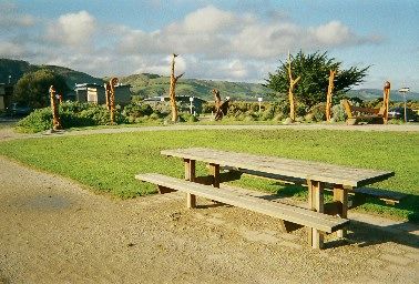
•   Indigenous heritage
•   Cypress trees on foreshore
•   Village feel – preserve fishing village atmosphere, relaxed and friendly
    atmosphere
•   Fishing industry
•   Encourage diversity of businesses – independent retailers (no McDonalds and
    no pokies)
•   Open space on foreshore, active recreation areas and sporting complex
•   Enhance town and streetscape character
•   Provide height limits and building design guidelines and balance of housing
    types
•   Protect foreshore
•   Provide for permanent growth – jobs, health system etc.
•   Landscape, vegetation, trees/bush, rolling hills, pristine beaches, birdlife
•   Maintain existing boundaries between townships
•   Health and education services
•   Airport.

3. What opportunities could be realised to improve the town and its setting?
•   More parkland (other than foreshore)
•   Shared pathways, especially to Skenes Creek
•   Bypass road behind town, or one way flow on Great Ocean Road
•   Improved water supply
•   Restore and revegetate Barham River and wetlands, and other estuaries and
    tributaries
•   Beautify harbour and link to the shops – maintain golf course as public land
•   18 hole golf course – on sustainable site (not on the floodplain)
•   Heated swimming pool/hot sea baths
•   Properly planned streets for connectivity (no cul de sacs)
•   Define and beautify gateways to townships
•   Diversity of employment opportunities and commercial development (no
    McDonalds or pokies), establishment of cottage industries, fish farming, market
    gardens, strengthen local primary industry
•   Develop local character, create an icon
•   Improved traffic and parking (including bus parking)
•   Foreshore – retain and improve picnic areas, provide tennis, bike tracks,
    playgrounds
•   Protect foothills
•   Provision of international airport
•   Retain and enhance indigenous vegetation
•   Maintain gaps between township
•   Provide incentives to encourage environmental initiatives
•   Tourism - Develop culinary opportunities associated with fishing industry, cater
    for low income tourists (e.g. backpackers), Ecotourism opportunities – marine
    resource centre, farm stays etc.
•   Develop the Saturday market, festivals
•   Improved recreation facilities, upgrade pony club.

                                                                                       3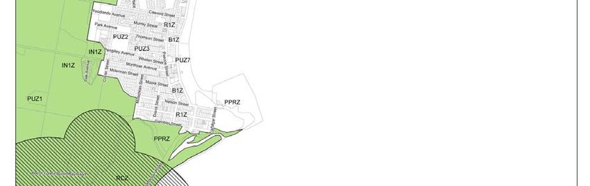
4. What would you change about Apollo Bay if you had a magic wand?
•   Lower rates for permanent residents
•   Clean up industrial estate
•   Upgrade Skenes Creek-Forrest Rd, upgrade Mariners Lookout
•   Provide better street planning, underground power
•   Hot sea baths, warmer sea water
•   Central Sports complex
•   Bulldoze sand dunes to provide views/retain sand dunes
•   Retain golf course
•   Turn developers into greenies
•   Create some ‘no car zones’
•   Clean runoff and river water, revegetate estuary
•   Ring road, one way main street, traffic lights
•   More trees, remove pest trees, more exotic planting, revegetate bare hills with
    original vegetation (no development)
•   Increased diversity of native birds
•   Sustainable town (economically sustainable, solar passive design), improved
    design and design controls, height limit of 8 metres, monitor/police
    developments and permits
•   Housing cascading down hill (Mariners Vue)
•   Foreshore (retain and improve picnic areas), remove toilet block on foreshore
    opposite pub
•   Improved access, parking, alternative transport
•   Keep it as it is!
•   More dining choices, new picture theatre
•   Greater contributions from Council.

5. What three words would you use to describe Apollo Bay?
Top three words from each workshop:
Apollo Bay workshop: Treasure, unique, paradise
Melbourne Workshop: Tranquil haven, idyllic, scenic lookout

                                                                                      4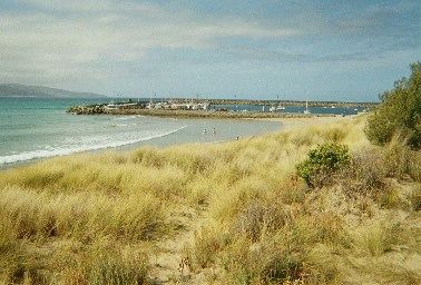
Disposable Camera Exercise
Disposable cameras were distributed to 10 volunteers amongst those who attended
the Community Workshop in Apollo Bay on 26 September, 2005. The purpose of the
exercise was to gain a better understanding of the community’s perceptions and
values about different aspects of the study area through a photographic survey of the
area. Participants were asked to take photographs of places or things that they like
or dislike, as well as good examples of new development (buildings or places), and
provide details for each photograph.
In summary, the photographic survey revealed that great value is placed on the
scenic views in the area, in particular to the hills, the harbour, across the sand
dunes, the beach, and the view from Mariner’s Lookout. Participants also like the
green spaces in and around Apollo Bay (golf course, farmland, hills, wide streets with
grass verges and natural edges), and comments were made about preserving this
and restricting the extension of residential areas. Similarly, for Skenes Creek the
participants value the natural landscapes and vegetation, with houses set within the
landscape and not dominating it. The new sculptures, information centre and native
landscaping were also liked. Examples of aspects of the area that are liked are
shown below.
Beach and Harbour: The beach and harbour are Barham River Floodplain: Rural green belt between
crucial focal points for visitors and residents alike. Apollo Bay and Marengo
A large proportion of the photographs taken of things people dislike were of new
developments. Negative comments were made about overdevelopment,
contemporary design, insufficient space around new dwellings for landscaping,
impacts on views and neighbours, creation of concrete urban jungles, and buildings
being unsympathetic to the character or scale of the town, the neighbouring
dwellings or the landscape/streetscape. Criticisms were also made of physical
infrastructure provision and maintenance: damaged roads (pot holes, cracks) and
poor road edges, lack of footpaths, unmade drains, developers constructing poor
quality roads before handing over to Council, the need for slip lanes for traffic turning
off the Great Ocean Road, and improvements needed to the swimming pool. Other
things people disliked or wanted to see improved were the industrial area and
rubbish tip, the presence of weeds (blackberries, pampas grass, pittosporum, arum
lilies), and better control of windblown sand around harbour and dunes. Concerns
were raised about rising sea levels and the future impact on the area.
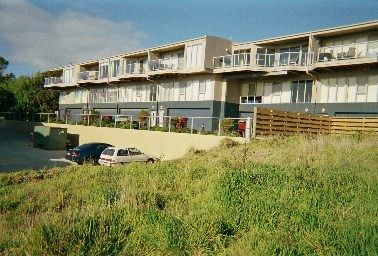
Nizam Quay: Totally out of character for this Units at Wild Dog development: Very
area of town (plenty surrounding land). unsympathetic materials, crude building form
with overbearing straight skyline.
5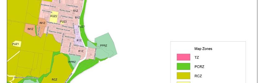
There were comparatively few photographs taken of recent developments or
buildings or spaces that people liked, and where these were taken, there was a high
level of disparity in terms of what is liked and disliked. While some identified
buildings in this section as examples of good development, in some cases others
had identified the same or similar buildings as examples of what they dislike about
the area. Reproduction styles are liked by some and contemporary styles are liked
by others. In general, however, people are opposed to development of a larger scale,
especially with straight, unarticulated forms, and especially if not screened by
landscaping (or no allowance made for future landscaping). Subdivisions with wider
streets and more generous setbacks are liked, as well as buildings that blend in with
the natural environment. Buildings that use similar materials to existing houses and
draw on similar themes are also liked, and extensions that carry through the existing
style of dwellings are approved of. The recent development of the skate park and the
information centre was liked.

Gateway development: Good combination of modern   Sculptured poles and Information Centre: Need to
practice and traditional materials and style.     encourage Artist community in Apollo Bay.
                                                  Information Centre set with wonderful native
                                                  vegetation – great setting for market!

A representative selection of the photographs and captions from the photographic
survey will be used in the public display during the next stage of community
consultation.

Questionnaire
A questionnaire attached to the Community Bulletin No. 1 was widely distributed in
September 2005, and a total of 113 completed surveys were returned. The
questionnaire posed 4 questions which sought qualitative responses from the
community:
     1. What are the major town planning challenges for Apollo Bay?
     2. What opportunities could be realised to improve the town and its
     setting?
     In planning for the residential and visitor accommodation growth allocated
     to Apollo Bay:
     1. What challenges will need to be addressed?
     2. What existing features should be protected/strengthened?
A number of key themes and issues emerged through the analysis of the responses,
which have been summarised below for each question and grouped by theme.

                                                                                                     6
1. What are the major town planning challenges for Apollo Bay?

Providing Clear Direction and Managing Different Perspectives
Respondents identified that major town planning challenges for Apollo Bay will be
providing clear direction and vision, generating increased confidence in Shire (better
decision making, less financial waste, fairer distribution of funds and representation
of Apollo Bay residents, and better communication between residents and Council).
The different views and desires of the community need to be balanced, and balance
between residents and tourists needs to be found. A challenge will be for the
community to admit/come to terms with the fact that change and growth will happen,
and ensuring that it happens in a sensitive and eco friendly way.

Managing Development Pressures
A significant challenge that was identified was how to manage the pressure for
development. Respondents identified limits that should be imposed on new
development, including: preventing high rise development and dense development,
particularly immediately along the coastline (2 storeys); allowing no more than 2 units
per block; requiring larger allotments in new subdivisions (define minimum lot sizes);
ensuring adequate building setbacks; minimising suburban style of development.
The need to ensure “green belts” between townships are retained and town
boundaries set to limit urban sprawl was also seen as an important challenge. Other
development challenges included ensuring the provision of affordable housing (to
enable retirees and others to stay in the town), increasing the commercial zone
(encourage businesses area into Pascoe St), retaining the 8m height limit and
placing more restrictions in older residential areas. Respondents were clear that they
did not want to see high scale development like at Lorne.

Protecting Character and Environmental Values
Key challenges that were identified included ensuring the protection of views and
natural beauty, open space, the open and undeveloped hills. The retention/relocation
of the golf course was seen as important, and if relocated the community would like
to see the land preserved as well as open space for public use. The proposed site for
the new golf course was contentious, with respondents keen to see the continued
protection of the Barham River floodplain and improvements made to the river. Other
environmental challenges included restricting further clearing of bushland and
encouraging new planting on hills, promoting native vegetation, and replacing
cypress trees along the Great Ocean Road (with Norfolk Pines or palms).
Within the townships themselves, respondents identified important challenges to be
retaining traditional streetscapes, maintaining the open feel, and protecting the
heritage and the character of the area, as well as improving the presentation of the
foreshore, harbour and environs.

Meeting Infrastructure needs
Respondents frequently raised concerns about the ability of the existing
infrastructure and service levels to keep pace with the development of the town and
the increased pressures this would place on the town and environs. In particular, the
provision of utility services to meet future demands was identified as a challenge:
water supply/storage, electricity, sewerage, access, natural gas.
Some identified the challenge of a potential rise in sea level, and the need for
infrastructure to protect the town (sea wall etc).

                                                                                     7
Improving Accessibility
Accessibility challenges were identified in relation to traffic management, car parking
and improving infrastructure and amenity for pedestrians and cyclists. Specific ideas
for improving these issues were provided, including: constructing a ring road,
protecting road infrastructure from the ocean, providing an inland route to Apollo Bay
(in case cut off by natural disaster e.g. tidal wave), providing off street parking in
Pascoe St, Apollo Bay, creation of one way streets (especially during peak tourist
season) to control traffic.
Pedestrian and cyclist accessibility challenges included providing improved access to
the harbour, providing a walking/bike path from Marengo-Skenes Creek, improving
pedestrian access, providing footpaths and seating away from the main shopping
strip. The provision of a courtesy bus from Skenes Ck to Marengo, and the relocation
of the airfield (e.g. to Cape Otway) were also seen as important.

Meeting Community and Visitor Needs
The need for wider employment opportunities (other than building and tourism),
especially employment opportunities for youth (golf club, airfield, harbour etc) was
seen as a major challenge to ensure the ongoing viability of the community. The
improvement of health services, including a permanent paramedic, a heated pool for
the elderly and a heliport, was also seen as important.
There was strong recognition of the value of the tourist industry and the need to
provide for visitor needs, including through the provision of campsite, student and
youth group accommodation, as well as new attractions and activities/centres for
youth (holiday activities, upgrade of amusement centre etc).

2. What opportunities could be realised to improve the town and its setting?
The opportunities identified by respondents for this question were largely aimed at
addressing the challenges identified in the first question, including:

Providing Clear Direction and Managing Different Perspectives

Managing Development Pressures
Development opportunities and opportunities to better manage development
pressures included:
−   Better utilisation of harbour (dive centre, restaurants, shops, museum etc),
    connect to township (perhaps with boardwalk).
−   Encourage environmentally friendly developments and sustainable buildings.
−   Encourage Great Ocean Green Development – will clean up waste land and
    attract visitors.
−   Encourage tasteful developments that protect the charm of Apollo Bay.
−   Set height restrictions on foreshore area.
−   Promote higher quality architecture (less suburban), ensure low visual impact of
    development.
−   Encourage natural energy sources – wind and solar – and water recycling
−   Stop large scale developments.

Protecting Character and Environmental Values
Opportunities for protecting the character and environmental values of the study area
included:

                                                                                     8
− Reduce/remove sand dunes for views that were available 50-100 years ago, or
conversely, preserve the dunes.
− Improve streetscape planning, with community participation.
− Improve the foreshore: replace trees that have been removed; provide new
trees that can be established by the time the existing cypress trees are
removed; provide tables and chairs near Wild Dog Creek.
− Complete initiatives that are started, such as the neighbourhood character study
− Revegetate hills.
− Provide more trees around the town.
− Introduce landscaping requirements for the industrial estate.
Meeting Infrastructure needs
Identified infrastructure improvement opportunities included:
− Replace open drains with kerb and channel,
− Provide maintenance to footpaths, walking tracks and roads.
− Improve storm water management.
− Relocate airfield to Cape Otway, relocate transfer station.
− Put powerlines underground.
− Provide seating in backstreets for elderly to rest.
− Provide undercover pavilion areas for shelter on foreshore and jetty.
− Provide public toilets at Skenes creek
Improving Accessibility
Opportunities for improving accessibility included:
− Improve traffic flow (provide parking to rear)
− More parking for tourist buses.
− Divert delivery and industry vehicles off Great Ocean Road into Pascoe St.
− Improve road surfaces.
− Provide footpaths.
− Provide foreshore parking near Wild Dog Creek.
− New cycling tracks
Meeting Community and Visitor Needs
Opportunities included:
− Provide for a future municipal precinct (library etc).
− Provide a heated pool/thermal baths, tennis courts, retain current golf
course/provide 18 hole golf course (without all the units).
− Enforce local laws re. dogs on beach and in public areas.
− Develop parkland for children’s activities away from town centre.
− Pedestrian crossing and lighting in Great Ocean Road.
− Build upon Apollo Bay Music festival profile.
− Better quality retail outlets, retail in Marengo and Skenes Creek.
− Community garden, more seating, increased parkland.
− Tourist attractions that tell the history of the town.
− Increase native vegetation and promote as ecotourism location.
− Walking track in hills, walking/cycling tracks Marengo-Skenes Creek, along
creeks.
− Provide another post box south of Apollo Bay.
9In planning for the residential and visitor accommodation growth allocated to
Apollo Bay:
1. What challenges will need to be addressed?
Again, the challenges respondents identified as needing to be addressed aligned
closely with the feedback received in the above two questions. Particular challenges
identified here included:
− Providing clear planning regulations (and enforcement) to avoid constant
battles.
− Ensuring infrastructure, health and other services and facilities are able to cope
with growth and change of the community (e.g. as the population ages).
− Providing affordable housing for locals, providing open space.
− Managing population growth.
− Dealing with conflicting interest groups: developers vs. others interested in
maintaining the character of the town.
− Overcoming local paranoia about development – need to reach agreement
about what change is appropriate and have a united vision.
− Limit multi storey development and denser development, improve architecture to
reflect character of town.
− Encouraging Ecologically Sustainable Design in new development.
− Ensuring that higher density development is encouraged closer to the town
centre.
− Preserve town character through implementation of the Planning Scheme,
especially by managing growth, maintaining green space between towns and in
the hills, managing the spatial distribution of new housing – focus more inland
and provide town boundaries.
− Managing traffic and parking issues – heavy vehicles, tourist traffic, traffic
management infrastructure (including traffic light at pedestrian crossing),
providing for and encouraging walking and cycling, improving public transport
services.
− Preserving bushland, replacing vegetation, managing weeds, managing litter,
managing impacts of development on natural environment (creeks and
floodplains, vegetation removal, introduction of weeds), considering possible
impact of greenhouse effect and increased irregularity of weather patterns on
urban settlement.
− Managing tourist function of town – providing a balance of tourist
accommodation (affordable to high quality), providing tourist facilities and
amenities, maintaining balance between tourists and residents, no pokies.
− Improving streetscape amenity – verandahs for shops, parks and foreshore to
have rotundas and shelters to provide weather protection.
− Golf course – residents want a golf course but many do not want to see it in the
proposed new location, and do not want to see a high level of development in
the existing golf course location (would like to see this stay as public open
space).
10In planning for the residential and visitor accommodation growth allocated to
Apollo Bay:
What existing features should be protected/strengthened?
Existing features that were valued and commonly identified to be protected and/or
strengthened included:
− Parklands and foreshore (including dunes and trees), foreshore market,
recreation reserve, tennis courts.
− Unspoiled beaches, surf club.
− The hills
− Views – to the hills, to the beach, from the lookouts., from the harbour.
− Pier/jetty, commercial fishing.
− Barham River and floodplain.
− Golf course (preserve as public open space or retain golf course)
− Harbour – new development is OK if integrated with current facilities. Protect
views and character, provide better facilities for boat users and tourists, retain
co-op, link harbour with town centre.
− Main street – shopping precinct, keep development consistent in form.
− Youth club.
− Waterfalls, walking tracks, nature reserves, bird and wildlife habitat, bushland,
wetlands.
− Rivers/creeks and estuaries.
− Historical sites, old buildings.
− Surrounding rural areas – keep them this way, encourage hinterland farming.
− Relaxed lifestyle and walkability of town, seaside/village atmosphere.
− Streetscapes – plant more trees, replace old trees along foreshore.
− Emergency services, strengthen police presence.
− Landcare and Coastcare activities.
− Protection of wildlife corridors.
− Enforcement of landscape and vegetation controls through planning scheme.
− Improve and maintain walking/cycling paths and footpaths.
As expected, the issues and opportunities raised by respondents in the
questionnaires were similar to the feedback that came out of the community
workshops, although they offered an opportunity for more detailed comments to be
made. While respondent views on some matters varied, a number of key themes
were able to be identified in the feedback that demonstrated common goals amongst
the community and other stakeholders. In particular, these related to the preservation
of the character, landscape qualities and environmental values of the study area and
the need to meet the ongoing needs of the community, and the necessity of
balancing these objectives against the development and tourism pressures which in
turn are critical in sustaining the community and ensuring the ongoing viability of the
townships.
Project Steering Committee
In November 2005 a Project Steering Committee (PSC) was formed, including four
community representatives, to provide input throughout the development of the
Structure Plan. Two meetings have been held so far, with the first being to discuss
issues and opportunities to be explored through the development of the Structure
11Plan. An Issues and Opportunities Paper was prepared for discussion purposes, and
feedback was sought on this paper from members of the PSC, before the
preparation of a Structure Plan outline which as presented to the PSC at the second
meeting.
Comments were received from 5 members of this group as well as key stakeholders
and several members of the community on the Issues and Opportunities. These
comments were taken into consideration during the preparation of the draft Structure
Plan.
Many of the comments received, particularly those outside the PSC, replicated
comments received through the community consultation process. New issues and
opportunities were also identified, and clarification on some aspects was able to be
provided.
Comments made that varied from comments received through previous consultation
included:
− The ‘health and wellness’ theme used by the Chamber of Commerce should be
incorporated:
− For the harbour
− For the creation of a pedestrian and bicycle friendly town
− For sustainable design and development.
− Infrastructure will be a limiting factor – particularly water storage and electricity
supply. Reticulated gas is also being explored for the settlements.
− Medium density housing will be necessary – but the Neighbourhood Character
Study is limiting potential.
− Traffic and parking – suggestions were made for improvements (e.g. Great
Ocean Road one way traffic, improving bus parking and pedestrian issues in
Moore Street).
− Environment – weeds in foothills and valley a significant issue. Retaining
cleared farmland is not sustainable as agriculture is unviable and there is no
incentive to manage weeds.
− Recreation – new facilities should be clustered together.
− Cultural/archaeological signficance of the harbour and Point Bunbury noted.
− Comments on the hard edge versus soft edge were made.
− Comments were also made on the development proposals of the Great Ocean
Green and Mariners Vue, with arguments for and against each proposal
represented.
Comments received in relation to the Structure Plan outline during the second PSC
meeting were also invaluable and were used in the finalisation of the draft Structure
Plan.
12Consultation B:
Draft Structure Plan
Overview
Community consultation on the draft Structure Plan was carried out between late
January and early March 2006, and involved two public information sessions, during
which Council staff and project team members were available to explain the Plan,
answer questions, and provide guidance about how to make a submission. The
exhibition period closed on 6 March 2006, and during this time 422 submissions
were received.
Of the 422 (439 minus 17 duplicate submissions) which were received, 216 were
proforma submissions, and 206 individual submissions. The proforma submissions
comprised 7 different template responses sent from different parties.
The proforma submissions indicated varying levels of support for the Structure Plan,
with approximately 67% expressing at least some support for the Structure Plan
overall in addition to outlining issues they considered needed to be addressed. It was
unclear whether the remainder of the proforma submissions were supportive overall
or not.
One of the proforma submissions, with 67 responses, was primarily related to
ensuring that provision is made for the continuation of golf in the Structure Plan.
Three proforma submissions, 1 with 18 responses, 1 with 26 responses and 1 with
27 responses, were in relation to a wide range of planning issues, and were
generally in support of the Structure Plan.
Two proforma submissions, 1 with 28 responses and 1 with 47 responses, had the
main purpose of supporting the development of Mariners Vue, and expressed doubts
about the land supply figures. These submissions indicated general support for the
Structure Plan. In addition, 1 proforma submission with only 3 responses was made
in relation to the land supply estimate used for the structure plan.
As a proportion of the proforma submissions, approximately 36% were primarily
written in support of the Mariners Vue proposal, 33% covered a wide range of issues
(2 including the Mariners Vue proposal), and 30% were primarily in relation to golf.
Of the remaining 206 individual submissions, approximately 27% expressed support
for the overall Structure Plan, while only 7 submissions (3.3%) were unsupportive of
the overall Structure Plan and process. The remainder of submissions (70 %)
outlined various issues but did not clearly express whether they were in support of
the Structure Plan overall.
Comments were received from the community and stakeholders on a broad range of
issues, with the most frequently raised comments, issues and concerns summarised
as follows:
Environmental Constraints to Growth:
• The ability of the settlements to supply water to an increased population, with
calls to restrict spa baths and require water tanks in all new developments.
• Impact of development on the floodplain, including increased impacts of
flooding, need to improve ecological values, and the need to maintain a green
break in this area.
13• Impacts of climate change including sea level rises, increased storm surges and
increased variability of rainfall.
• Potential impacts of disturbing acid sulphate soils, including the need to add a
discussion and management strategies, and to map affected areas.
• Strong support for protecting hill back drop and managing landslip and erosion
risk, including restricting development to below the 40-50 metre contour,
although some wanted clearer definition of what this meant. Some submissions
considered the 30 metre contour to be more appropriate as a limit to
development, others preferred the 50 metre contour, while others thought it
should be determined on a site by site basis.
• Concern that wildfire risk was not adequately addressed.
• There was strong support for management of weeds and planting of indigenous
species (in settlements and foothills). There were calls for inventories of
landscape elements/significant habitat areas and protection of iconic cypress
trees (or their replacement). Conversely, concerns were also raised about trees
blocking views. There was general support for the proposed Significant
Landscape Overlay, although there was some concern about its restrictiveness.
Size of Settlements:
• The green breaks and maintenance of distinct settlements was seen as critical
by many submitters, although there was some concern that the Structure Plan
won’t achieve this. The need to provide clearer definition of “low scale
development” was raised several times, along with concern that development on
the floodplain will not provide a green break.
• Some acceptance of growth and change and the need to place limits on urban
sprawl by defining a hard edge to development. Frequent support for using
landscape features to define growth, and for defining the northern urban
boundary at Pisces Caravan Park (although some submitters argued that the
boundary should be at Wild Dog Creek or alternatively at Marriners Lookout Rd,
• Most of the concerns relating to land supply appeared to be raised by
proponents of current and possible future development proposals (e.g. north of
Pisces Caravan Park), and those in support of Marriner’s Vue. Others identified
the apparent glut of vacant lots, properties on the market and pointed out that
figures used in land supply calculations were based on boom times which will
not be sustained. Land supply figures calculated by submitters were between
4.5 years and 18 years.
• Concern about the ability for sewerage infrastructure and electricity supply to
support an increased population. Need to indicate buffer around wastewater
treatment plant. Support for installation of rainwater tanks, and ensuring that
infrastructure provision occurs prior to further development.
• Improvements to the appearance and landscaping of industrial areas needed.
Need to ensure relocation of transfer station and concrete batching plant.
• Strong support for initiatives to increase the environmental sustainability of the
settlements and new development, particularly in relation to water use. Mariners
Vue proposed development was raised several times as a good example of
ecologically sustainable development.
• Land to the west of Pascoe St was raised as a necessary extension of the
commercial area. The need for a convenience shop at Skenes Creek and
Marengo was raised several times, although an equivalent number of
submissions agreed that no shops should be provided in either settlement.
14Built form, density and character:
• The 3 storey height limit in the town centre was frequently raised as a concern,
although support for 3 storey height limits was also frequently demonstrated in
submissions, particularly within the commercial areas. Submissions often stated
that building height limits should stay the same, while others suggested height
limits varying from 7.5 to 10 metres for the town centre. Submissions called for
greater clarity on the meaning of “innovative, high quality design” for buildings in
the town centre.
• In residential areas there were fewer concerns raised about height limits,
although many submissions called for the height limits (8 metres) to stay the
same. Some also called for them to be increased to 9 metres so that there
would be more certainty at VCAT.
• Submitters often stated that they did not desire to live in medium or higher
density housing, were concerned about impacts on adjoining dwellings, and
called for minimum block sizes to be established.
• Support expressed for the retention of fishing village character, and for
protection of the neighbourhood character of older residential areas. Support for
initiatives to protect these values, although still some concerns about building
designs and the need to define “excellent architectural quality” in the structure
plan.
• Support for objectives to protect views, but needs to be stronger on protection of
public views. Concern about higher buildings and canopy trees blocking views.
Access:
• Concerns were raised about the rising cost of fuel and the impact that this would
have on travel patterns and tourism potential. The need to plan for an additional
crossing of the Barham River was also raised several times, to address the risk
of losing access in the event that a storm event closed bridge access.
• The need for a bypass road to take traffic out of the town centre and the
provision of an alternative route for industrial traffic was frequently raised.
Strong support for improved cyclist links and for strengthening emphasis on
sustainable transport. Need to address traffic issues in summer, particularly
through the Apollo Bay town centre.
• High level of agreement with creating a walkable town centre, prioritising the
provision of footpaths, improving pedestrian safety and accessibility for the
elderly.
• Agreement that public transport improvements are needed, including a shuttle
service between the settlements operating throughout the year.
• Improvements to car parking needed, particularly in peak periods. Provision of
improved bus drop off points and parking needed. Concern about Parking
Precinct Plan, need to outline this in the Structure Plan.
Providing for the social and recreational needs of the community and
providing for tourism:
• Need a stronger discussion of employment and economic development,
including the viability of growth.
• More detail on recreation needed, including planning for improved/new
swimming pool, tennis courts, pony club. Need to provide for more parklands
and provide a greater commitment to public open space away from the
foreshore.
• Provide stronger support for the continuation of golf in the town, and a solution
for the relocation of the golf course, including identification of an alternative site.
15Need to recognise tourism potential of golf, and preserve the existing golf
course site as open space.
• Retain harbour as a working port, provide improved facilities for port users,
residents and tourists. Redevelopment should not include accommodation, and
should include only minimal commercial premises. Protect Point Bunbury as
public open space.
• Varying views presented about the future of the airfield, with support for
retaining an airfield in the region expressed.
• Initiatives to restrict new development and car parking on the foreshore, provide
further revegetation and control of weeds, and providing improved amenities
supported. Varying perspectives on dune management were expressed.
• Initiatives to promote tourism, jobs and activity supported, and calls for tourism
to have stronger recognition for its role as a major economic driver. Potential
tourist facilities were identified, including various information centres and
museums, and continuation of golf in the town.
• The affordability of dwellings was frequently raised as a concern, including the
concern that medium and higher density housing is not more affordable. Need
to provide diverse and affordable housing for locals, employees and the elderly
recognised.
• Need to provide for improved community services and facilities to support a
growing and ageing community, particularly health services. Need to strengthen
this part of the Plan.
Proposed developments: Great Ocean Green and Mariners Vue:
• Concerns raised about the consideration of current development proposals as a
part of the structure planning process.
• Strong concerns raised about Great Ocean Green and development on the
floodplain, loss of green break between the townships, impact on waterway,
increased impacts of flooding, presence of acid sulphate soils, visual impact of
dwellings and golf course. Support for golf course but not dwellings, preference
to see this land improved as open space and for ecological values.
• Varying levels of support for Mariners Vue: support for increased supply of
residential land with sea views in a quality development incorporating
ecologically sustainable features; and opposition also expressed for the impacts
on views from the current edge of the town and from Marriners Lookout.
Other issues:
• More detail needed about how the Structure Plan will be implemented and
monitored.
• Varying levels of support for the process of developing the Structure Plan, with
concerns raised about the level of consultation, information provided, the length
of the consultation period, and the community representation throughout the
project.
• Further detail is needed in the background section is needed to provide further
support for the main part of the Structure Plan.
• Comments about the overall plan included the need to provide a clearer vision
or the need to provide greater detail, while others were strongly supportive of
the Plan overall,
These and many more comments were addressed in the Recommended Changes
Report adopted by Council in May 2006, and changes have now been made to the
final Structure Plan where appropriate to accommodate suggestions.
162. Strategic Context
The Planning Scheme provides a strategic context within which the Structure Plan
needs to be considered. Previous studies provide useful background information
that needs to be taken into account.
State Planning Policy Framework (SPPF)
The SPPF sets out statewide planning policy, with relevant policies for Apollo Bay
contained in the sections Settlement, Environment, Housing, Economic
Development, Infrastructure and Particular Uses & Development.
Settlement
A sufficient supply of land needs to be available for a wide variety of uses, with
consolidation of existing urban areas and higher density development encouraged
near public transport. Orderly development is to be achieved through preparing
structure plans that provide for sustainable, integrated, liveable urban development
that maximises efficient use of infrastructure.
Environment
Consideration needs to be given to a number of state-wide environmental objectives,
in particular:
• Protecting and restoring catchments, waterways, waterbodies, groundwater and
the marine environment.
• Managing floodplains to protect life and property from flood hazard, protect flood
capacity of rivers, protect flood storage function, and protect environmental
significance of floodplains.
• Minimising the impact of salinity and rising water tables.
• Controlling noise effects on sensitive land uses.
• Minimising risks from wildfire.
• Protecting and enhancing coastal and marine ecosystems and landscapes,
ensuring sustainable use of natural coastal resources, and ensuring
development provides economic, social and environmental benefits. Further
strategies are also set out for the Great Ocean Road Region in relation to:
Protecting the landscape and environment
Managing the growth of towns
Improving the management of access and transport, and
Encouraging sustainable tourism and resource use.
• Assisting the protection and conservation of biodiversity.
• Creating a network of public open space to meet community needs.
• Conserving places of natural, environmental, aesthetic, historic, cultural
scientific or social significance.
• Encouraging efficient use of energy and minimisation of greenhouse gas
emissions.
• Promote renewable energy provision.
17Coastal Areas
Clause 15.08 of the SPPF was amended on 9 October 2006. This clause now clearly
articulates and implements the land use and development strategies of the Victorian
Coastal Strategy 2002 and the State Government policy context arising out of the
Coastal Spaces Report and Great Ocean Road Region Landscape Assessment
Study. The clause includes the following relevant strategies:
General
Planning for coastal areas should:
• Encourage urban renewal and redevelopment opportunities within existing
settlements to reduce the demand for urban sprawl.
• Avoid linear urban sprawl along the coastal edge and ribbon development within
rural landscapes and preserve areas between settlements for non-urban use.
• Protect identified visually significant landscapes, views and vistas in coastal
areas
• Protect non-urban areas for their visual landscape, environmental, agricultural
and recreational qualities.
• Retain the existing subdivision patterns and non-urban uses between
settlements.
• Identify and avoid development in areas susceptible to flooding (both river and
coastal inundation), landslip, erosion, coastal acid sulfate soils, wildfire or
geotechnical risk.
• Avoid development within the primary sand dunes and in low lying coastal
areas.
• Avoid disturbance of coastal acid sulfate soils.
Great Ocean Road Region
Planning for the Great Ocean Road Region should:
• Protect the landscape and environment by:
o Protecting public land and parks and identified significant
landscapes.
• Manage the growth of towns by:
o Directing urban growth to strategically identified areas.
• Encourage sustainable tourism and resource use by:
o Developing a network of tourism opportunities throughout the region.
o Supporting tourism activities that provide environmental, economic
and social benefits.
Housing
Relevant policies relate to single dwellings, medium density housing, rural living and
rural residential development, and crisis accommodation and community care units.
Key objectives that are of relevance to the study area, include encouraging:
• Subdivisions in locations with good access to physical and community
infrastructure, road access, pedestrian and cycle accessibility and open space.
• Residential development that is cost effective in terms of infrastructure
provision, is energy and water efficient and encourages public transport use.
• Increased residential densities to encourage urban consolidation.
• Well-designed medium density housing that improves housing choice, offers
increased energy efficiency and efficiency of infrastructure use while respecting
neighbourhood character.
18• Identification of land suitable for rural living and rural residential development.
• Establishment of crisis accommodation and community care units in confidential
locations in residential areas.
Economic Development
Relevant policies relating to economic development are summarised as:
• Activity Centres: encourage the concentration of major retail, commercial,
administrative, entertainment, tourist and cultural development in activity centres
to provide a wide variety of uses in highly accessible locations.
• Business: encourage developments that meet the community’s need for retail,
entertainment, office and other commercial services.
• Industry: ensure the availability of land for industry and facilitate its sustainable
development and operation.
• Tourism: encourage tourism development to maximise employment and long-
term economic, social and cultural benefits.
• Agriculture: protect the State’s agricultural base and productive farmland that
is significant in the local or regional context.
Infrastructure
It is State policy that integrated land uses are provided around existing and planned
transport services. Access to a development should take into account all modes of
travel, including walking, cycling, public transport, taxis and private vehicles. Bicycle
travel is to be integrated with land use and encouraged as an alternative form of
transport.
Airfields are to be sited (or extended) so that they restrict incompatible land uses in
the vicinity. Development around airfields should not prejudice the operation of the
airfield, should take into account the detrimental effects of the airfield and should not
prejudice future planned extensions.
Health and education facilities should be integrated with the local and regional
communities having regard to demographic trends and access requirements.
The provision of water supply, sewerage and drainage services should be planned
for to ensure they meet community needs while protecting the environment.
Developer contributions should be considered for the partial provision of community
and physical infrastructure.
Particular Uses and Development
Relevant policy includes Design and Built Form, which requires high quality urban
design and architecture that has regard to its context, the public realm, landmarks,
vistas and views, pedestrian spaces, heritage, consolidation of sites, light and shade,
energy and resource efficiency, architectural quality and landscape architecture.
Municipal Strategic Statement (MSS)
The MSS is contained within the Colac Otway Planning Scheme and provides
strategic direction for land use and development in the Shire. It is noted that the
existing MSS was reviewed and a rewrite of the MSS was carried out, with an
amendment exhibited in 2003 to replace the existing MSS in the Planning Scheme.
However, the amendment was abandoned by Council in mid 2005 and consequently
the current MSS does not reflect the most recent strategic work of the Council.
19However, until a new amendment is prepared, the current MSS needs to be
considered as a part of the structure planning process.
Numerous planning objectives and strategies contained within the MSS relate to the
study area and the development of a structure plan for the area. For Apollo Bay,
Marengo and Skenes Creek the following specific objectives and strategies apply:
• A key objective is “to enhance the role of Colac and Apollo Bay as key
settlements, to strengthen the linkages between these and the smaller
communities of the Shire and provide limited opportunities for rural living
where these do not detract from the key environmental qualities of the region.
This will be achieved by facilitating the development of the various settlements
in accordance with the needs of each of the local communities.
• A specific objective for Apollo Bay (including Marengo) is “to develop Apollo Bay
as an attractive residential community which provides high quality environment
as a significant tourist centre”. Strategies to achieve the objective relate to
promoting a high quality identity for the town, providing a range of residential
development opportunities, facilitating provision of infrastructure to support
environmentally sensitive development, promoting the provision of
community services, and promoting the commercial future of Apollo Bay.
A Framework Plan for Apollo Bay is included at Clause 21.04-10:
• A separate objective for the smaller communities in the Shire, including Skenes
Creek, is “to provide an attractive, safe, residential environment and strengthen
the economic future of the small communities in the Shire”. Strategies to
achieve this objective relate to promoting the economic future of small
communities, facilitating provision of infrastructure to support environmentally
sensitive development, and maintaining and enhancing the environmental
quality of small towns.
20Other relevant planning principles include:
• Improving road, rail, air and port facilities to provide better access to
international and domestic markets.
• Sustainably managing the natural and cultural resources of the Shire.
• Ensuring settlement patterns provide a balance between development
opportunities with the need to protect the key visual, environmental and
cultural features of the Otway Coast.
• Retaining and increasing the younger age groups in the demographic profile
through the facilitation of increased economic development and employment
opportunities, in order to increase population levels throughout the
municipality.
• Promoting environmentally responsible development of sustainable
agriculture and fishing and related activities, especially where they provide
links to the tourist industry.
• Encouraging tourism growth that diversifies the local economic base and
protects the key visual environmental features that attract tourism, including
encouraging links between tourism and local industries, providing a range of
accommodation and tourist activities and enhancing the transport network.
• Enhancing the transport network to improve the accessibility of the region
(particularly for key primary industries and tourism activities) by developing a
balanced transport network, enhanced road network and improved air and train
services.
• Maintaining and enhancing a network of cost-effective facilities and services
to all communities in the Shire.
Local Planning Policies (LPP)
Local planning policies provide additional guidance in the planning process and
come into play when discretion is able to be exercised in the decision making
process. All of the current LPPs in the Colac Otway Planning Scheme have some
degree of relevance to the subject area and the Structure Plan.
22.01 Main Roads/Scenic Routes
This policy applies to land adjacent to a number of roads within the study area: the
Great Ocean Road, Skenes Creek Road, Forrest-Apollo Bay Road and Mariners
Lookout Road. Key objectives of the policy relate to protecting scenic roads from
unsympathetic development so as not to detract from the beauty of the area,
ensuring a high level of visual amenity, while at the same time protecting the
capacity, safety and appearance of these roads. The policy includes guidelines for
buildings and works, materials and landscaping.
22.02 Ridgelines
This policy applies to development on prominent ridgelines, including those in the
foothills surrounding Apollo Bay. The policy aims to ensure that development in
these locations avoids detracting from views through appropriate building design and
use of landscaping to blend the development into the form of the land.
22.03 Tourism Development – Apollo Bay Harbour Precinct
This policy applies to the land within the Public Park and Recreation Zone at Apollo
Bay Harbour, as well as the adjoining Residential 1 Zone bounded by Nelson Street,
Trafalgar Street, Gambier Street and Sylvester Street (Great Ocean Road). The
21policy encourages new tourist facilities to locate in this area that are designed to be
sympathetic with the local setting and compatible with surrounding coastal and
residential uses.
22.04 House Lot Excision in the Rural & Environmental Rural Zones
This policy applies to the Environmental Rural Zoned land surrounding the townships
in the study area, and places additional restrictions on the subdivision of land to
ensure that it is compatible with surrounding land uses and does not prejudice
sustainable resource use and rural production activities.
22.05 Coastal and Otway Ranges Townships
The townships of Apollo Bay, Marengo and Skenes Creek are affected by this policy,
which has built form, design and landscaping requirements to ensure that new
development minimises visual impact on these scenic coastal environments, while
also recognising the role of each of the townships.
Zones and Overlays
Land use zones control the uses that can occur on land and overlays generally
control the form that the development may take.
Zones:
The following zones apply within the study area as shown on the Zone Plan in
Appendix A:
Residential 1 Zone
This zone applies to the majority of the land within the town centre of Apollo Bay, as
well as a large area of Marengo. This zone provides for residential development at a
range of densities with a variety of dwellings to meet the housing needs of all
households.
Low Density Residential Zone
This zone applies to the residential area to the north of Marengo, adjoining the
airport, and provides for low-density residential development, which can treat and
retain all wastewater in the absence of reticulated sewerage.
Township Zone
The built up area of Skenes Creek is subject to the Township Zone. This zone varies
from other residential zones in that it also provides for a range of commercial,
industrial and other uses in small towns.
Business 1 Zone
The commercial centre of Apollo Bay along the Great Ocean Road is subject to the
Business 1 Zone, which encourages the intensive development of business centres
for retailing and other complementary commercial, entertainment and community
uses.
Special Use Zone 1 – Apollo Bay Airfield
This zone applies to the airport land to the south of Apollo Bay. The zone provides
for specific purposes set out in the schedule to the zone. The schedule allows for the
use of the land in accordance with a submitted concept plan.
22You can also read