Agroforests, swiddening and livelihoods between restored peat domes and river: effects of the 2015 fire ban in Central Kalimantan (Indonesia)
←
→
Page content transcription
If your browser does not render page correctly, please read the page content below
382     International Forestry Review Vol.22(3), 2020

Agroforests, swiddening and livelihoods between restored
peat domes and river: effects of the 2015 fire ban in
Central Kalimantan (Indonesia)
Y.A. SILVIANINGSIHa,b, K. HAIRIAHc, D. SUPRAYOGOc, M. van NOORDWIJKc,d,e
a
  Faculty of Agriculture, University of Palangka Raya. Kampus UPR Tunjung Nyaho, Jalan Yos Sudarso, Palangka Raya, Indonesia
b
  Graduate Studies Program, Faculty of Agriculture, Brawijaya University, Malang, Indonesia
c
 Agroforestry Research Group, Faculty of Agriculture, Brawijaya University, Jl. Veteran no 1, Malang
d
  World Agroforestry Centre, ICRAF, Indonesia Office, Bogor, Indonesia
e
 Plant Production Systems, Wageningen University, the Netherlands

Email: yosefin_ari@for.upr.ac.id, kurniatunhairiah@gmail.com, suprayogo09@yahoo.com, m.vannoordwijk@cgiar.org

HIGHLIGHTS
•   Dayak Ngaju villagers have traditionally combined agroforest and swidden/fallow rotations on riverbanks and shallow peat.
•   Rich ethnobotanical knowledge, local soil quality indicators and ceremonies reflect long-term presence in this landscape.
•   The 2015 fire ban has effectively stopped local rice cultivation as technical alternatives are not attractive.
•   The agroforests, with durian and rubber as marketed products, continue to support livelihoods, but are not sufficient.
•   Temporary jobs on canal blocking for the peatland restoration agency have filled the gap, but are not expected to last.

SUMMARY

If 150 years of continued use counts as a sustainability indicator, the river-bank agroforests in the peat landscapes of Central Kalimantan suggest
solutions for current challenges. The 2015 fire season in Indonesian peatlands triggered a fire ban and peatland restoration response, prioritizing
canal blocking and rewetting. However, sustainable livelihood options remain elusive. We report local ecological knowledge of soils and
vegetation applied in land use choices in swiddens and agroforests in five Dayak Ngaju villages in Jabiren Raya and Kahayan Hilir subdistrict
(Pulang Pisau, C. Kalimantan, Indonesia) on the banks of the Kahayan river and discuss impacts of fire-ban policies. Plots accessible from the
river with no or shallow peat were traditionally preferred for swiddening, with various indicator plants and soil characteristics underpinning
the choices. Without swiddening farmers depend on off-farm jobs and agroforests for income. More policy attention for non-peat riparian-zone
agroforestry as part of peat landscape livelihood systems is warranted.

Keywords: agroforestry, ethnobotany, fire ban, local knowledge, peatlands, soil indicators, swidden

Agroforêts, cultures sur brûlis et moyens d’existence entre tourbières bombées et rivière: effets
de l’interdiction des feux de 2015 au Kalimantan Central (Indonésie)
Y.A. SILVIANINGSIH, K. HAIRIAH, D. SUPRAYOGO et M. van NOORDWIJK

Si 150 années d’usage continu comptent comme un indicateur de durabilité, les ripisylves agroforestières dans les paysages de tourbières du
Kalimantan central suggèrent des solutions pour les défis actuels. La saison d’incendies de 2015 dans les tourbières indonésiennes déclencha
une réponse d’interdiction des feux et de restauration des tourbières, en priorisant le blocage des canaux et le remouillage. Cependant, les
possibilités de revenus durables demeurent plutôt insaisissables. Nous rapportons la connaissance écologique locale des sols et de la végétation
appliquée aux choix d’utilisation de la terre dans les cultures itinérantes sur brûlis et les agroforêts dans cinq villages Dayak Ngaju dans les
sous-districts de Jabiren Raya et Kahayan Hilir (Pulang Pisau, C. Kalimantan, Indonésie) sur les rives de la rivière Kahayan, et nous discutons
les impacts des politiques d’interdiction des feux. Les parcelles accessibles de la rivière avec peu, ou pas de tourbe, ont été traditionnellement
préférés pour la culture sur brûlis, avec diverses plantes-indicateurs et caractéristiques du sol guidant les choix. Sans culture sur brûlis, les
exploitants dépendent d’emplois hors ferme ou de l’agroforesterie pour leurs revenus. Il est nécessaire de porter plus d’attention dans les
politiques sur l’agroforesterie de bord de rivière sans tourbe comme faisant partie des systèmes de revenus des paysages de tourbières.
Agroforests, swiddening and livelihoods between restored peat domes and river            383

Agroforestería, roza y quema, y medios de vida entre los domos de turba restauradas y el río:
efectos de la prohibición de quemas de 2015 en Kalimantan Central (Indonesia)
Y.A. SILVIANINGSIH , K. HAIRIAH, D. SUPRAYOGO y M. van NOORDWIJK

Si el uso continuo durante 150 años cuenta como un indicador de sostenibilidad, la agroforestería en las riberas de los humedales (zonas de
turberas, pantanos naturales) de Kalimantan Central, nos ofrecen soluciones para los desafíos actuales. La temporada de incendios en 2015 en
las zonas de turberas de Indonesia desencadenó la prohibición de quemas y la restauración de turberas, dando prioridad al bloqueo de canales
y a rehumedecer las turberas. Sin embargo, opciones sostenibles de sustento siguen siendo difíciles de alcanzar. Este estudio reporta cono-
cimiento ecológico de comunidades locales sobre suelos y vegetación aplicado en decisiones sobre uso del suelo en áreas de roza, tumba y
quema y sistemas agroforestales. Cinco poblados Dayak Ngaju en el sub-distritos de Jabiren Raya o Kahayan Hilir (Pulang Pisau, Kalimantan
Central, Indonesia) fueron analizados en las orillas del río Kahayan y se discuten impactos de las políticas de prohibición de las quemas. Par-
celas accesibles desde el río son preferidas tradicionalmente con o sin turbas poco profundas para llevar a cabo la agricultura de roza, tumba y
quema, empleando varias plantas como indicadores, así como características fisicoquímicas del suelo para elegir estas opciones de manejo. Sin
la posibilidad de efectuar roza, tumba y quema, los ingresos de los agricultores dependen de la agroforestería y de trabajos no agrícolas. Se
justifica entonces que se preste más atención a las políticas destinadas a promover la agroforestería en zonas ribereñas sin turberas como parte
del sustento en los ecosistemas de turbera.

INTRODUCTION                                                               minorities within nation-states, privatization and commoditi-
                                                                           zation of land and land-based production, and expansion of
As elsewhere in Southeast Asia, livelihoods strategies and land            market infrastructure and the promotion of industrial agricul-
use systems at the forest/agriculture interface in Kalimantan              ture. In a global assessment van Vliet et al. (2012) concluded
have gradually increased in intensity due to the interactions              that despite decline, swidden cultivation remains an important
with global markets, followed by a ‘dual economy’ track at                 element of tropical forest-agriculture frontiers. In the context
local scale of providing for local needs as well as income                 of climate change policies, van Noordwijk et al. (2015)
(Dove 2011). In a subsequent national-scale interpretation                 distinguished between contexts where A) swiddening is still
of a dual economy, logging concessions became a source of                  the locally preferred land use, B) contexts where there has
income primarily for stakeholders outside the landscape,                   been a voluntary shift to other sources of local and/or off-farm
while getting into conflict with local swiddening traditions as            livelihoods, and C) contexts where policies, such as no-burn
basis of local needs. Swiddening has for millennia of human                policies, are actively enforced and farmers urgently need
existence been the basis for local food security strategies,               alternatives. The use of fire for land clearing in landscapes
through both its cropping and fallow phases (Cramb et al.                  with tropical peats is now in that third category and livelihood
2009, Mizuno et al. 2013). In response to market demand for                transitions are imposed on local communities. The challenge
‘forest products’, the fallows in many parts of southeast Asia             for public policies is to turn a type-C imposed abandonment
transformed into agroforests that complemented remaining                   of fire as traditional tool for re-opening swiddens into a
old-growth forests as a source of marketable products and                  type-B voluntary choice as there are attractive alternatives.
local food (de Foresta et al. 2000, van Noordwijk et al. 2008a).           Our case study delved into these issues.
Depending on accessibility and the terms of trade, transitions                 Several of the large rivers of Borneo and Sumatra have
occurred to ‘outsourcing’ rice as a staple food that can be                an extensive lowland section where peat domes developed
obtained from trading canoes as well as from swiddens, while               in the interfluvial areas. These peat areas did not support
other parts of the diet and the fuel needed to cook it remained            human settlement, but their low-intensity use complemented
locally sourced (van Noordwijk et al. 2014a). A switch from                the river-bank agriculture and fishing. Only in the 1990’s
periodically shifting villages to permanent settlements with               when more favourable areas had been logged and in part
access to health and education services as well as government              converted to plantations (either fast-growing trees under
control, coincided with a greater role of the agroforests around           forestry rules or oil palm as an agricultural crop), attention
settlements as provider of income though products such as                  shifted to these peatlands, where a lack of local claims meant
rubber or durian. When land away from the river became                     less conflicts than on mineral soils. Conversion of large
claimed as ‘state forest’ (Galudra et al. 2011), the river-based           areas of Indonesian peatland into agricultural lands for estate
economy became enriched with sawmills fed from commer-                     crop production and plantation forest brought short-term
cial logging concessions, supporting the dual economy.                     economic gains, but also posed major environmental, health
    Changes in agricultural patterns from swidden to perma-                and economic risks and loss of globally significant biodiver-
nent cultivation occurred in many regions in Indonesia                     sity contained in natural peat swamp forests (Uda et al. 2017).
at various points in time (van Noordwijk et al. 2008a,b,                   Peat-based communities in Central Kalimantan had to adapt
Hariyadi and Ticktin 2012, Li et al. 2014, Dressler et al.                 their livelihoods to changing peatland conditions and man-
2017). A review of the declining role of swiddening in                     agement policies (Jewitt et al 2014). The most striking case
Southeast Asia (Fox et al. 2009) identified seven contributing             is the Mega Rice Project, which logged and transformed a
factors, including the division of landscapes into forest and              million hectares for resettling farmers from elsewhere to grow
permanent agriculture, treatment of swiddeners as ethnic                   irrigated rice. Currently known as the Ex Mega Rice Project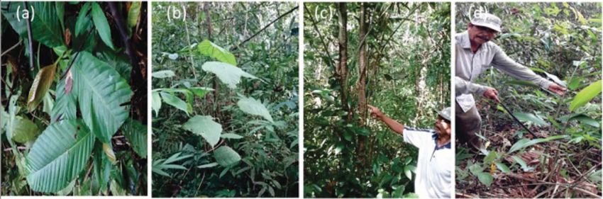
384    Y.A. Silvianingsih et al.

(EMRP), technical and social failure of the resettlement            strategies to achieve an ecological-economic balance and a
scheme has shifted attention back to the original inhabitants       sustainable management of tropical smallholder landscapes
of the peatland landscape and to efforts to restore ecosystem       must be prioritized to avoid further environmental degrada-
services (provisioning, regulating, cultural; Law et al. 2015a).    tion. Such strategies will have to start from a stocktaking of
    Under President Joko Widodo’s first administration peri-        what exists.
od, the government prioritized restoration and rehabilitation           Analysis of land use plans for the area surrounding the
of peatlands by establishing the Peat Restoration Agency            EMRP (Law et al. 2015a, 2015b) have considered ‘small-
(BRG), based on Government Regulation No.1 of 2016, to              holder agriculture’ and ‘riparian forest’ but not the ‘riparian
accelerate the recovery of integrated functions of peat hydrol-     agroforest’ that can be seen in the Jabiren Raya sub district
ogy and avoid future fire episodes like the one experienced         along the Banjarmasin – Palanga Raya road. Government
in 2015. One of the priorities of BRG activities in Central         documents attributed the fires to ‘slash-and-burn’ practices by
Kalimantan Province is in Pulang Pisau District, in the form        local communities(also known as swidden re-opening) and to
of canal blocking to reduce the rate of drainage and keep the       land clearing to support land claims (Medrilzam et al. 2014).
peat dome wetter at the start of a dry period and making bore       Unintentional spread of such fire use, without effective
holes (wells) to have water readily available to extinguish fire    control, was seen as part of the cause in the fires culminating
if needed. The aim of these activities is to restore a shallow      in the 2015 event (Ardhian et al. 2016, Lohberger et al. 2018).
ground water level and reduce the fire risk in remaining            In response, the fire ban that previously had exempted small-
forests and agricultural land. Both state-sponsored efforts         scale farmers was reframed to apply landscape-wide to all
that tried to undo the failed projects together with locally fire   actors (Page and Hooijer 2016). Where prior to the 2015 fires
ban for agricultural purposes have created new challenges for       a lack of commitment to act had been the bottleneck (van
existing swidden practices.                                         Noordwijk et al. 2014b), the agenda shifted to finding practi-
    Previously, internationally funded efforts to control carbon
                                                                    cal, operational solutions after the Peatland Restoration
emissions from the landscape had revealed that the area is a
                                                                    Agency (BRG) had been constituted. Together with the canal
‘hot spot’ for contested claims and conflicts between forest
                                                                    blocking and rewetting that tried to undo the failed projects of
authorities and local communities over the forest designation
                                                                    the 1990’s, the fire ban created new challenges for existing
of riparian-zone lands that had previously been respected as
                                                                    swidden practices. Economically attractive forms of ‘paludi-
under ‘adat’ (customary law) control (Galudra et al. 2011).
                                                                    culture’ and agroforestry not requiring extensive drainage
Project documents and planned interventions did not refer to
                                                                    (ASEAN Secretariat 2013, Wetlands 2016, Widayati et al.
agroforests as part of the traditional land use or conceive them
                                                                    2016, Medrilzam et al. 2017) are urgently needed in these
as part of a desirable solution.
    The absence of ‘agroforest’ categories in the legal frame-      landscapes, both for the riparian edges and the peat domes.
works for land use planning and the lack of interest in the         Paludiculture is a productive use of peat swamp to protect
production plus conservation properties of these systems (Fay       peatlands without drainage or canal blocking so that the peat
& Michon 2005, Fay & Sirait 2005, Michon et al. 2007),              stays wet. Paludiculture (Tata 2019) can provide fruits such
has led to a conceptual dichotomy between agriculture and           as durian (Durio sp.) or mango (Mangifera sp.), commercial
forestry that has discouraged gradual transitions and interme-      wood species like kahui (Shorea blangeran), and medicinal
diary systems. De Foresta et al. (2000) described agroforests       plants such as papar buhu (Antidesma coriaceum Tul). Exist-
in Indonesia as based on planting beneficial trees on farm          ing agroforests close to the river and their historical interac-
(often starting with swiddens), with tree canopy structures         tion with swiddens may offer traditional knowledge of soil
that resemble tree structures in forests, providing a home to       and water management (Barrios et al. 2012) that is relevant in
many forest organisms. Van Noordwijk et al. (2019) discussed        the current discussions. Ethnobotanical surveys may reveal
how interpretations of agroforestry as a dynamic system of          which plants are considered to have local indicator value of
natural resource management, through integration of various         environmental conditions, beyond any direct use value.
types of trees species on land and in agricultural landscapes,          The current exploration of local knowledge and practices
requires policy change to secure the economic, social and           in the area between the Kahayan river and the peat domes
environmental benefits it can provide to various segments           to its West and East was initiated to answer the following
of society. These benefits can be understood as four type of        questions:
ecosystem services i.e. (a) provisioning of foods, timber,
fibre, fruit and medicines, (b) regulating the flow of clean           1. How are land use practices including swiddening and
water and clean air (Mainka at al. 2008), (c) supporting the              agroforests positioned in the river-peat dome gradient
development of biodiversity, soil formation, and (d) preserv-             and associated with local knowledge of soil and water
ing culture, landscapes beauty, and maintaining germplasm                 management?
(MEA 1994).                                                            2. How is land use associated with ethnobotanical knowl-
    Recent land-use choices follow profitability at the expense           edge of plants as indicators of land quality and as
of ecological functions in Indonesian smallholder landscapes              sources of livelihoods?
(Clough et al. 2016), as the more profitable oil palm and              3. In what way did the ‘fire ban’ of 2015 affect existing
rubber monocultures replace forests and agroforests critical              land use practices and food production by the local
for maintaining above- and below-ground ecological functions              communities and what alternative options do they
and the diversity of most taxa. According to their analysis,              currently have?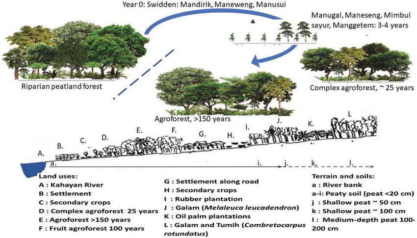
Agroforests, swiddening and livelihoods between restored peat domes and river 385
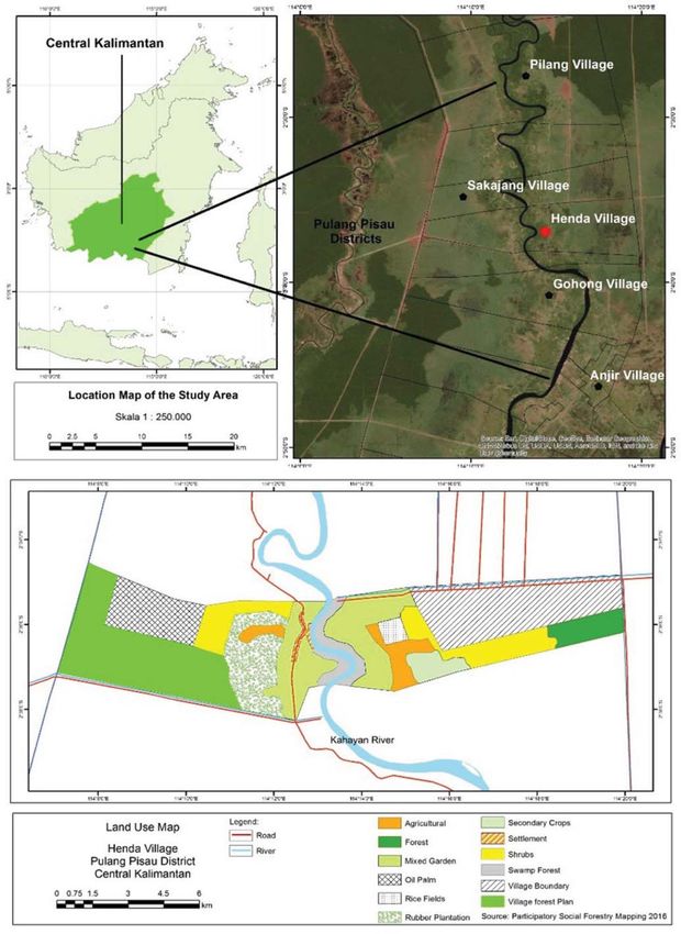
FIGURE 1 Google.Earth image of the landscape in Pulang Pisau regency southeast of the provincial capital Palangka Raya
along the road to Banjarmasin, with the riparian agroforest in Jabiren along the Kahayan river, intact peat swamp forest to the
West (left) and areas affected by the Ex-Mega-Rice project to the East
METHODS Gohong (60 km2, 1808 inhabitants, 30.1 km−2), Anjir Pulang
Pisau (22 km2, 4407 inhabitants, 200.3 km−2) (BPS 2018a,
Geographical context 2018b). Henda Village, the oldest among the five, with the
most extensive land area and widest range of land uses, in the
Central Kalimantan is dominated by river deltas and wetlands middle of the study landscape was chosen for more detailed
that are now understood to be part of Peat Hydrology Units observations.
(KHG = Kesatuan Hidrologi Gambut). A large area of
wetlands (around 440,000 ha) is located in the Pulang Pisau Collection and analysis of data
Regency. It became known as ‘Block C’ in the EMRP (Lestari
2016). The economic wheel in Pulang Pisau Regency depends The local communities along the Kahayan river identify
on the agricultural sector (Pemerintah Kabupaten Pulang themselves as Dayak Ngaju. Various groups of migrants,
Pisau 2015), while the availability of agricultural land area is under the government-sponsored transmigration program as
still limited; therefore, the potential for conversion of forest well as spontaneous migrants, have also settled in the area,
land remains a key interest. Five villages on the Kahayan river coming from Bali, Java, Flores and elsewhere in Kalimantan.
were selected for this study, three (Pilang, Henda, Sakakajang) Only villages that described themselves as of Dayak Ngaju
in Jabiren Raya Sub-District (Pulang Pisau District), two ethnic origin were considered in this research, as we wanted
(Gohong and Anjir Pulang Pisau) in the Kahayan Hilir Sub- to document local ecological knowledge with historical
District (Figure 2). roots in this landscape. Permission for research was obtained
The study area (1°32′00′-3°28′00 South, 113°30′00- from the village elders, and the first author, with five years’
120°00′00 East) borders Gunung Mas Regency in the North, experience in the area was welcomed in the homes of many
Kapuas Regency in the East, the Java Sea in the South and villagers, with follow-up interviews in the field, and partici-
Katingan Regency and Palangka Raya City in the West. The pation in village events. Data collection was carried out by
five study villages are: area of Pilang (area about 180 km2, surveys, field observations, and in-depth interviews with
1320 inhabitants, 7.3 km−2), Sakakajang (60 km2, 768 inhabit- 20 key informants (purposive sampling) consisting of 18 men
ants, 12.8 km−2), Henda (538 km2, 648 inhabitants, 1.2 km−2), and 2 women.386 Y.A. Silvianingsih et al. FIGURE 2 (A) Five study sites in Pulang Pisau District, South Kalimantan, (B) Land use types in the peat landscape (BRG 2018)
Agroforests, swiddening and livelihoods between restored peat domes and river      387

    Key informants were land-owners with deep knowledge              community cultivation on peatlands. All data obtained were
of the land history from forest-land clearing stage to land          described in a qualitative descriptive manner (Miles et al.
cultivation, had knowledge about various types of beneficial         2014, Robertson et al. 2017, Schüler and Noack 2019), and
plants and/or have been managing land in these villages.             are presented in an anonymized way and in summary form in
Further knowledge was shared by women who joined in the              this paper to respect the privacy of respondents.
collection of biophysical data. In-depth interviews were con-
ducted in the Dayak Ngaju language and Bahasa Indonesia.
The interviews were recorded, fully transcribed and interpreted      RESULTS
into Bahasa Indonesia. Where interviews appeared to provide
conflicting information, joint field visits were made to ensure      Land use patterns
information was correctly interpreted and was related to field
                                                                     Part of the current agroforestry lands managed by Dayak
data. Data on shallow-peat tree indicators and useful ethnobo-
                                                                     Ngaju farmers were passed down from three or four genera-
tanical plants were then matched with the tree flora for
                                                                     tions before the current owner. Allocation and management of
Kalimantan edited by Whitmore et al. (1990).                         those lands, as well as the use of communal land rights and
    A quick soil assessment was carried out using Munsell            land conflict resolution always refer to the customary leader
Soil Color (1994) charts. In-depth interviews and joint field        called Mantir Adat, who is elected by villagers within the
visits explored local ecological knowledge of indigenous             customary community. Agricultural activities in the Dayak
farmers. Some of the information gathered was related to soil        Ngaju culture are described through four important stages,
quality, an indicator of vegetation on peatlands. Problems           namely land selection, carrying out traditional ceremonies,
faced by farmers related to the implementation of government         planting and harvesting (Table 1). Traditional ceremonies
policies in preventing fires were a common topic of discus-          contain ritual elements in social life which are believed to
sion, as well as the impact of socio-economic changes on             provide success and safety for farmers.

TABLE 1 Land use calendar for swidden cultivation and the swidden-fallow cycle
 Implementation                   Stages                                                Activity
 Before clearing the      Ritual (salvation)   Ceremony of salvation and success by securing agreement from supernatural
 forest for cultivation   Ceremony (mangariau, beings in the prospective land. Activities led by adat leaders or shamans, by
                          menyanggar)          washing offerings in the Kahayan river, in containers made of bamboo
                                               (kelangkang). The upright position of the kelangkang when it is washed away,
                                               signifies nature allows the land to be cleared. All customary rule violations, will
                                               attract a curse (pahuni).
 July                     Open land                Conducted in groups and led by someone considered an elder
 July–August              Land clearing            Cutting down small trees and herbs (mandirik) and cutting down large trees
                                                   (maneweng).
 September                1. Burning the cut       Slash and burn activity after making firebreaks (around the plot) and keeping fire
                          biomass (manusul)        from creeping or jumping to other areas (pusuk menyawung), guarded in groups
                                                   by working together (handep).
 September                Planting rice            Planting upland rice varieties (mountain rice, ‘iwau’, ‘geragai’, ‘kawung’ and
                          (manugal)                red rice). Rice seeds are obtained from the old generation, bought or borrowed
                                                   (manalisih) from farmers who still have them. After 10 days, rice will be
                                                   replanted (maneseng) to replace dead rice plants. This activity is in conjunction
                                                   with growing vegetables (mimbul sayur), to fulfil daily needs; types of
                                                   vegetables planted include beans, karwila (Luffa acutangula), hot pepper
                                                   (Capsicum frutescens), cucumber (Cucumis sativus), bitter gourd (Momordica
                                                   charantia) and eggplant (Solanum melongena).
 November–December        Weeding (membawau)       Weeding is carried out when the rice is 2 months old, to avoid damage on main
                                                   crops.
 March                    Harvesting rice
                          (menggetem)

 Subsequent years         Subsequent rice crops,   Repeated rice planting activities for up to 3 or 4 times depend on soil fertility.
                          or transition into       If soil fertility decreases, shown by a decline in rice production, then land
                          agroforest               management shifts to (inter)planting (sisipan) rubber and local fruits such as
                                                   various mangoes (Mangifera sp.), cempedak (Artocarpus integer), durian (Durio
                                                   sp), manggosteen (Garcinia mangostan), rambutan (Nephelium lappaceum) and
                                                   ‘rambai’ or ‘buah menteng’ (Baccaurea motleyana).
388 Y.A. Silvianingsih et al.
Local knowledge of ‘improved fertility’ by the traditional of water saturation, soil acidity, and nutrient availability for
and controlled use of fire in land clearing, locally termed plants. This land is not entirely flat; there are parts in the form
‘manusul’, is supported by soil science. Ash produced from of higher basins and surfaces. Farmers prefer higher land
wood and litter burning during this manusul provides soil surface with peat thickness less than 20 cm (which is also just
nutrients and increases soil pH (Rodenburg et al. 2003, a mineral soil), which is suitable for annual crops such as
Huotari et al. 2015), as it has high concentration of K, Ca and upland rice and vegetables. Farmers will plant trees (rubber
Mg (Hairiah et al. 2011), while organic P can be mobilized and various local fruits) in the third or fourth year of cropping
(Ketterings et al. 2002). Rice can be planted for 3–4 years and leave it to become an agroforest. The land is called high
only and is followed by planting of rubber and fruit trees, land/hanging plot/embankment land or meaning high land/
after which land is left as ‘fallow’ for several years until a transition lands/embankment land, characterized by being
multistrata agroforestry is formed (Figure 3A). located near the river and unflooded even at the peak of the
Utilization of land for agriculture in Henda historically rainy season or at the highest tides. On the other hand, there
started from the Kahayan riverbank (both on the right and left are also land conditions that are avoided by farmers, namely
side of the river). More recent agricultural land uses contin- petak rendah, hapu, luwau. These lands are positioned in
ued to develop at increasing peat depths and distances to the low-lying land so that they can be flooded during the rainy
river (Figure 3B). season and the highest tides. Peat thickness in such lands was
observed to be 20 to 50 cm.
Local knowledge of soil fertility There are various terms in local use for the maturity of
Peat swamp land use for agriculture along the banks of the peat, such as “raw” peat, “half mature” or “half-cooked”, and
Kahayan river needs to take the tidal pattern of the river “mature” or “cooked” peat. “Raw” peat is found in all peat-
into account, some 50 km from the sea, as access by canoe is lands that have never been managed or cultivated before.
best during high tide. An important aspect of local knowledge Farmers choose peatlands for farming mostly based on peat
used by Ngaju Dayak farmers and passed on from generation depth, preferring shallow (thicknessesAgroforests, swiddening and livelihoods between restored peat domes and river 389
TABLE 2 Indicators used in selecting plots for swiddening
No Desired condition Unwanted condition
1. Agricultural land along the riverbank. The selected land is A distance to the river of more than 3 km.
within 2 km from the river (which aligns with historical
land rights).
2. * Peat thickness390 Y.A. Silvianingsih et al.
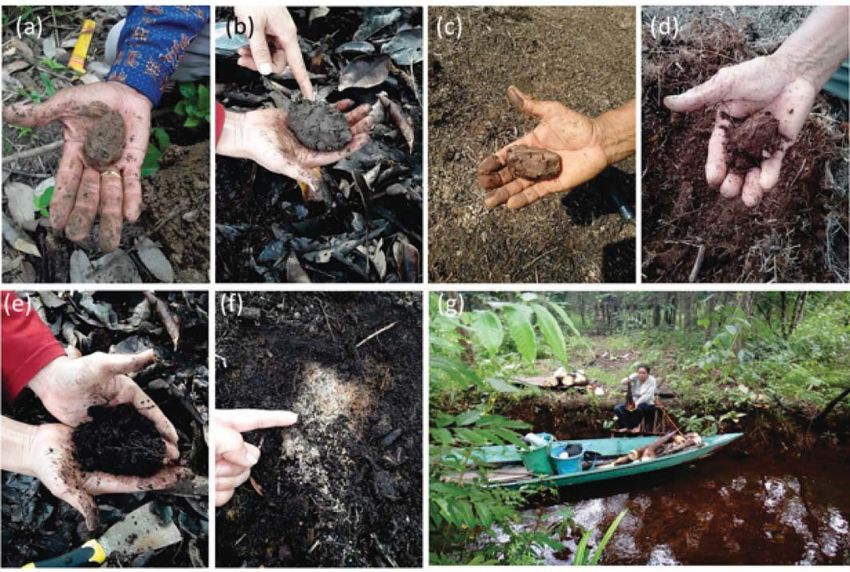
FIGURE 4 Indicators of soil quality: a), b) and c) Fertile soil, “with vitamin”, “protein”, “cool”, indicating “well-cooked” or
mature peat, d) and e) “half-cooked” peat soil, f) ash, g) preferred position relative to canal (“handel”) for easy access
FIGURE 5 Plants used as soil fertility indicators: (a) Simpur (Dillenia sp), (b) Mahang (Macaranga sp.), (c) Lepu (Korthalsia
flagellaris), (d) Suli (Hedychium coronarium)
capital for land preparation. Hence, only some joined the farmers from fruit tree production is influenced by the year
program. To date, no data on sengon production is available, and fruiting season. This is not worth the expenditure for rice,
because it was just planted three years ago, and could, whose prices vary between Rp. 7,000 kg to Rp. 14,000 per kg
supposedly, be harvested at the age of five years. in 2017 and 2018 (Disperindakop UKM, 2018). In the harvest
Many farmers felt they could not make ends meet, arguing season, some types of fruit are sold to traders who come to the
that farmers needed an estimated monthly rice consumption garden, but durian species will be prioritized to be distributed
of 30 kg for a family consisting of two adults. The income of in large families by a father who determines the managementAgroforests, swiddening and livelihoods between restored peat domes and river 391 TABLE 3 Various plants species as indicators of shallow or deeper peatlands Local name Botanical name Family Life form Type of Land Lepu, dahanen Korthalsia flagellaris Arecaceae Palm Shallow peatland (peat Simpur Dillenia sp. Dilleniaceae Tree thickness
392           Y.A. Silvianingsih et al.

TABLE 4 Useful plants (arranged by botanical plant family) in (agro)forests, according to local informants
                                                                         Plant                                              Actively
 Local Name                      Botanical name            Family                                      Use
                                                                         type                                              managed?
 Barania                   Bouea macrophilla          Anacardiaceae      Tree    Fruits, side dishes                       Yes
 Binjai                    Mangifera caesia           Anacardiaceae      Tree    Fruits, side dishes                       Yes
                   *
 Hampalam                  Mangifera sp.              Anacardiaceae      Tree    Fruits, side dishes                       Yes
 Kasturi                   Mangifera casturi          Anacardiaceae      Tree    Fruits, Building materials                Yes
 Tarantang                 Campnosperma coriaceum     Anacardiaceae      Tree    Medicine for uric acid (bark), building   No
                                                                                 materials
 Jelutung                  Dyera costulata            Apocynaceae        Tree    Latex, Building materials                 Yes
 Kalakai                   Stenochlaena palustris     Blechnaceae        Fern    Food supply after giving birth            No
 Jinjit                    Calophyllum hosei          Calophyllaceae     Tree    Building materials, menstrual medicine    No
 Manggis                   Garcinia mangostana        Clusiaceae         Tree    Fruit medicine for skin disease (latex)   Yes
 Simpur                    Dillenia sp                Dilleniaceae       Tree    Medication for dysentery (young           No
                                                                                 shoots)
 Sungkai                   Peronema canescens         Verbenaceae        Tree    Building material                         No
 Kahui                     Shorea balangeran          Dipterocarpaceae   Tree    Furniture                                 No
 Tamang                    Elaeocarpus glaber         Elaeocarpaceae     Tree    Food ingredients (fruit)                  No
          #
 Karet                     Hevea brasiliensis         Euphorbiaceae      Tree    Latex, Building material                  Yes
 Mahang                    Macaranga trilobal         Euphorbiaceae      Tree    Building material                         No
 Petai                     Parkia speciosa            Fabaceae           Tree    Vegetable                                 Yes
 Tapanggang                Adenanthera pavonina       Fabaceae           Tree    Black colouring (rattan woven)            No
 Rambai                    Baccaurea motleyana        Hyllanthaceae      Tree    Fruits, vegetable (rind)                  Yes
 Tabulus                   Litsea angulate            Lauraceae          Tree    Ingredients                               No
 (kalangkala)
 Putat                     Barringtonia asiatica      Lecythidaceae      Tree    Ingredients (vegetables)                  No
 Dehuyan                   Durio zibethinus           Malvaceae          Tree    Fruits, side dishes (tempuyak), timber,   Yes
                                                                                 the root used as a medicine after
                                                                                 childbirth
 Paken                     Durio kutejensis           Malvaceae          Tree    Fruit                                     Yes
 Kambasulan                Pternandra galeata         Melastomataceae    Tree    Skin medicine                             No
 Ruku                      Lansium domesticum         Meliaceae          Tree    Fruit, side dishes, vegetable (rind)      Yes
 Cempedak                  Artocarpus integer         Moraceae           Tree    Fruit, side dishes, vegetable             Yes
 Nangka                    Artocarpus heterophyllus   Moraceae           Tree    Fruit, vegetable                          Yes
 Talayar                   Ficus septica              Moraceae           Tree    Fodder, hemorrhoids medicine              No
 Hampuak                   Baccaurea bracteate        Phyllanthaceae     Tree     Building material, shoots (as            No
                                                                                 vegetable)
 Papar buhu                Antidesma coriace          Phyllanthaceae     Tree    Medication for delivery (root)            No
 Mangkudu                  Morinda citrifolia         Rubiaceae          Tree    Medication for kidney stones, high        No
                                                                                 blood pressure
 Rambutan                  Nephelium lappaceum        Sapindaceae        Tree    Fruits                                    Yes
 Kalapapa                  Vitex pinnata              Verbenaceae        Tree    Blood pressure medication (shoots),       No
                                                                                 wood for canoes and charcoal
 Suli                      Hedychium coronarium       Zingiberaceae      Herb    Young shoots (vegetables)                 No
∗ See: Noor et al. 2015
# Non-native, but naturalized
Agroforests, swiddening and livelihoods between restored peat domes and river 393
the use of fire for agricultural activities as before, with good Regarding our second question, land use was closely
village-level control within the customary rules. associated with ethnobotanical knowledge of plants as indica-
Farmers expressed hope that the government could review tors of land quality beyond their roles in livelihoods. While
the fire ban as a policy and allow controlled use of fire, as new market-oriented horticulture activities, such as growing
before. They also expect government officials to provide watermelon close to the main access road, have become part
solutions and guidance on sustainable land management of the land use system, the adoption of short-cycle tree planta-
before regulations are imposed on them. tions (sengon) cannot yet be evaluated. The traditional fruits
from the agroforests still provide a safety-net. The results
obtained in our study villages on the first two questions thus
DISCUSSION confirmed that most of the traditional human presence in the
peat landscapes (and peat hydrological units) has been
In relation to our first research question, our results confirmed focussed on the rivers, riverbanks and its non-peat or shallow
a close relationship between a swidden-fallow rotation at peat soils. Our results align with the view that when land use
some distance from the village, but accessible by canoe, and for agricultural activities in Kalimantan is to be reconciled
agroforests on the riverbank closer to the village. Livelihoods with restoration of peat domes (Page et al. 2009), a liveli-
centred on the river but interacted with the edges of the peat hoods perspective is needed, rather than a focus on the peat
dome. Land use practices were part of a rich local knowledge soils per se.
of soil and water management transferred from one genera- Our findings on the consequences of the ‘fire ban’ of 2015,
tion to the next within the customary institutions. The Ngaju the third research question, indicated that it affected existing
Dayak people living in peat landscapes (and peat hydrological land use practices and food production by the local communi-
units) focused on rivers, riverbanks and non-peat or shallow- ties, and also had implications for local culture and agricul-
peat areas. In the past groups could settle anywhere along the tural traditions that could no longer be followed. The existing
river system that they claimed to be their homelands. They government programs that were supposed to ease the transi-
selected locations that were considered to be suitable because tion to new ways of farming did not work for the villages
of soil fertility, accessibility, ease of management, peat thick- where we did the interviews. Temporary off-farm jobs offered
ness, being free from flooding, and the presence of indicator by the peatland restoration agency provided some relief, but
beyond that migration to the urban areas seemed to be the
plants. This knowledge is well kept across generations. Local
most attractive alternative option. Such responses call for a
knowledge in recognizing soil quality with diverse indicator
further reconsideration of the prevailing policies, as social
plants is the most important thing learned by local farmers for
consequences may not have been fully weighed when the
their agricultural success (Barrios and Trejo 2003, Lima et al.
policy was designed. The government support for mecha-
2011, Pauli et al. 2012). The Dayak Ngaju people usually
nized ‘modern’ styles of rice farming did not make this option
choose peaty soil (with insufficient peat depth to be classified
in the local circumstances.
as peat soil) or shallow peat for agricultural purposes. The
Forest and land fires in Indonesia in 2015 in Sumatra and
land was used for many years and as a result it contains no
Central Kalimantan followed earlier episodes in 1991, 1994
peat anymore. Locally this is known as mature peat. However,
and 1997 that put Indonesia at the receiving end of interna-
the definition of mature peat by the Ngaju Dayak tribe is quite tional criticism (Field et al. 2016). The current Indonesian
different from the one commonly used by researchers. Agus government approach prioritized restoration and rehabilita-
and Subiksa (2008) from the Indonesian Soil Research Insti- tion of peatlands by establishing the Peat Restoration Agency
tute, for instance, defined mature peat as weathered peat, with (BRG – based on PP. No.1 of 2016), to accelerate the recovery
its original material unrecognizable, and a colour ranging of integrated functions of peat hydrology. One of the priorities
from dark brown to black, with a fibre content less than 15% of BRG activities in Central Kalimantan Province is in Pulang
when squeezed. A similar definition is used by Agus et al. Pisau District, in the form of canal blocking and making
(2011) with the addition of fibre content of less than one-third bore holes (wells) to have water available to extinguish fire if
of all amounts when kneaded. The farmers use an agricultural needed. The aim of these activities is to restore a shallow
viewpoint while defining peatland. They always choose land ground water level and reduce the fire risk in remaining
with thin peat layers and prefer soils that contain a layer of forests and agricultural land. Farmers expressed hope that
clay so that after undergoing soil processing, when the peat controlled use of fire for their land clearing system using fire
will be exhausted, it is still fertile. Farmers believe that mature for swiddens can be allowed again, once the landscape has
peat is the best soil phase for agriculture. On the other hand, been rewetted. The important element for them is that adat
the researchers differentiate peat maturity based on the weath- customs can be maintained, including the rituals around land
ering process of original material. This indicates that farmers clearing and rice planting, but changing the farming pattern
only utilize peaty land, not peatlands. Farmers perpetually challenges those aspects. There are many benefits from slash
consider soil fertility, ease of land management, as well as and burn land clearing methods, as it is fast and practical,
operational costs. Hence, they have indirectly protected the and, most importantly, it reinforces the sense of community
peat ecosystem, although, due to increased economic pres- through traditional ceremonies. The knowledge and norms of
sure, farmers have begun to cultivate peat with a maximum behaviour that prevented swidden fires from escaping may get
thickness of 50 cm. lost from the local knowledge if it is no longer practised.394 Y.A. Silvianingsih et al.
As elsewhere, land management in the study area is AGUS, F., and SUBIKSA, I.M. 2008. Lahan Gambut: Potensi
influenced by socio-economic factors (Takele et al. 2015, untuk pertanian dan aspek lingkungan. Balai Penelitian
Handayu et al. 2019). Changes in cropping patterns are Tanah dan World Agroforestry Centre (ICRAF), Bogor.
adjusted to farmers’ needs, policies, markets and environmen- AGUS, F., HAIRIAH, K., and MULYANI, A. 2011. Penguku-
tal concerns (El Benni et al. 2012, Suprayogo 2017). Shifting ran cadangan karbon tanah gambut. Petunjuk Praktis.
cultivation in the tropics, generally has had to convert to World Agroforestry Centre-(ICRAF), SEA Regional
swidden rotations with a short fallow period. The efforts of Office dan Balai Besar Penelitian dan Pengembangan
Ngaju Dayak farmers to maintain their agricultural land in the Sumberdaya Lahan Pertanian (BSDLP). Bogor. Indonesia.
form of agroforest has worked for at least 150 years. They ASEAN SECRETARIAT. 2013. Asean peatland management
manage ‘internal rejuvenation’ and gap-level interplanting strategy 2006–2020. ASEAN secretariat, Jakarta, Indonesia.
or sisipan management (Joshi et al. 2003), avoiding field BADAN PUSAT STATISTIK (BPS). 2018a. Kecamatan
Jabiren Raya dalam Angka.
clearing and replant as is common in tree crop monocultures.
BADAN PUSAT STATISTIK (BPS). 2018b. Kecamatan
These land use practices need to be better understood as part
Kahayan Hilir dalam Angka.
of the peat ecosystem restoration program. The interaction of
BARRIOS, E., COUTINHO, H.L., and MEDEIROS, C.A.
farmers with peatland over a long time, has provided local
2012. InPaC-S: participatory knowledge integration on
knowledge to find indicators of land selection and types indicators of soil quality: methodological guide. World
of plants species. The success of peatland management is Agroforestry Centre (ICRAF), Nairobi, Kenya.
strongly dependent on the skills of farmers and local knowl- BRG (BADAN RESTORASI GAMBUT). 2018. Profil Desa
edge. The location of this research along the Kahayan river is Peduli Gambut: Desa Henda Kecamatan Jabiren Raya
close to the Banjarmasin – Palangka Raya road that forms one Kabupaten Pulang Pisau Provinsi Kalimantan Tengah.
of the gateways to change. This change has proved to be a BRG, Jakarta, Indonesia.
threat of damage to the peat ecosystem, with the economic CLOUGH, Y., KRISHNA, V.V., CORRE, M.D., DARRAS,
wheels of supposed progress in Pulang Pisau District blocked K., DENMEAD, L.H., MEIJIDE, A., and SCHEU, S.
by the public health disaster of the smoke and haze episodes 2016. Land-use choices follow profitability at the expense
in years with a long dry season when drained peat is vulner- of ecological functions in Indonesian smallholder
able to fire risk. For this reason, changes in socio-economic landscapes. Nature Communications 7: 13137.
conditions of farmers need to be given attention from the local CRAMB, R.A., PIERCE COLFER, C.J., DRESSLER, W.,
government, especially when the temporary job opportunities LAUNGARAMSRI, P., LE, Q.T., MULYOUTAMI, E.,
for canal blocking and rewetting provided by BRG are and WADLEY, R.L. 2009. Swidden transformations and
coming to an end. The villagers repeatedly asked us to convey rural livelihoods in southeast asia. Human Ecology 37(3):
this message to the outside world. 323–346.
DE FORESTA, H., A. KUSWORO., G. MICHON and W.A.
DJATMIKO. 2000. Ketika Kebun Berupa Hutan: Agrofor-
ACKNOWLEDGEMENTS est Khas Indonesia Sebuah Sumbangan Masyarakat Indo-
nesia. International Centre for Research in Agroforestry
This research was supported by the Indonesian Ministry of (ICRAF). Bogor. Indonesia.
Research, Technology and Higher Education. Our deep DOVE, M. 2011. The Banana Tree at the Gate. A History of
Marginal Peoples and Global Markets in Borneo. Human
gratitude to the people in Pilang, Sakakajang, Henda, Gohong
Ecology 40(1): 165–166.
and Anjir Pulang Pisau villages, especially to the Lambung
DRESSLER, W.H., WILSON, D., CLENDENNING, J.,
and Dillin family who hosted and facilitated the senior author
CRAMB, R., KEENAN, R., MAHANTY, S., BRUUN,
during her fieldwork. Kitso Kusin from Cimtrop (Center
T.B, MERTZ, O. and LASCO, R.D. 2017. The impact of
for International Co-Operation in Sustainable Management swidden decline on livelihoods and ecosystem services in
of Tropical Peatland) helped to process this research. Dr. Southeast Asia: A review of the evidence from 1990 to
Maswar and Pordamantra assisted in the research survey 2015. Ambio 46(3): 291–310.
activities. Endri Martini and Subekti Rahayu commented EL BENNI, N., FINGER, R., and MANN, S. 2012. Effects
on an earlier draft of the manuscript; we thank anonymous of agricultural policy reforms and farm characteristics on
reviewers for further suggestions. income risk in Swiss agriculture. Agricultural Finance
We thank the IFR editors, Alexandre Meybeck and Liliana Review 72(3): 301–324.
Bravo for help with the French and Spanish titles and abstracts. FAY, C., and MICHON, G. 2005. Redressing forestry hege-
mony when a forestry regulatory framework is best
replaced by an agrarian one. Forests, Trees and Liveli-
REFERENCES hoods 15(2): 193–209.
FAY, C., and SIRAIT, M. 2005. Kerangka hukum negara
ARDHIAN, D., ADIWIBOWO, S., and WAHYUNI, E.S. dalam mengatur agraria dan kehutanan Indonesia: Mem-
2016. Peran dan Strategi Organisasi Non Pemerintah pertanyakan sistem ganda kewenangan atas penguasaan
dalam Arena Politik Lingkungan Hidup. Jurnal Sosiologi tanah. International Centre for Research in Agroforestry
Pedesaan 4(3): 210–216. (ICRAF). Bogor. Indonesia.Agroforests, swiddening and livelihoods between restored peat domes and river 395
FOX, J., FUJITA, Y., NGIDANG, D., PELUSO, N., LI, P., FENG, Z., JIANG, L., LIAO, C., and ZHANG, J. 2014.
POTTER, L., SAKUNTALADEWI, N., and THOMAS, A review of swidden agriculture in Southeast Asia.
D. 2009. Policies, political-economy, and Swidden in Remote Sensing 6(2): 1654–1683.
southeast asia. Human Ecology 37(3): 305–322. LIMA, A.C.R., HOOGMOED, W.B., BRUSSAARD, L.,
FIELD, R.D., VAN DER WERF, G.R., FANIN, T., FETZER, and DOS ANJOS, F.S. 2011. Farmers’ assessment of soil
E.J., FULLER, R., JETHVA, H., and WORDEN, H.M. quality in rice production systems. NJAS-Wageningen
2016. Indonesian fire activity and smoke pollution in 2015 Journal of Life Sciences 58(1–2): 31–38.
show persistent nonlinear sensitivity to El Niño-induced LOHBERGER, S., STÄNGEL, M., ATWOOD, E.C., and
drought. Proceedings of the National Academy of Sciences SIEGERT, F. 2018. Spatial evaluation of Indonesia’s 2015
113(33): 9204–9209. fire-affected area and estimated carbon emissions using
GALUDRA, G., VAN NOORDWIJK, M., SUYANTO, S., Sentinel-1. Global Change Biology 24(2): 644–654.
SARDI, I., PRADHAN, U., and CATACUTAN, D. 2011. MAINKA, S.A., MCNEELY, J.A., and JACKSON, W.J.
Hot spots of confusion: Contested policies and competing
2008. Depending on nature: Ecosystem services for
carbon claims in the peatlands of central Kalimantan,
human livelihoods. Environment 50(2): 42–55.
Indonesia. International Forestry Review 13(4): 431–441.
MEDRILZAM, M., DARGUSCH, P., HERBOHN, J., and
HAIRIAH, K., UTAMI, S.R., SUPRAYOGO, D., SUNA-
SMITH, C. 2014. The socio-ecological drivers of forest
RYO, SITOMPUL, S.M., LUSIANA, B., MULIA, R.,
VAN NOORDWIJK, M., and CADISCH, G. 2000. degradation in part of the tropical peatlands of Central
Pengelolaan Tanah Masam secara Biologi. Refleksi Kalimantan, Indonesia. Forestry 87(2): 335–345.
Pengalaman dari Lampung Utara. International Centre for MEDRILZAM, M., SMITH, C., AZIZ, A.A., HERBOHN, J.,
Research in agroforestry (ICRAF). Bogor. Indonesia. and DARGUSCH, P. 2017. Smallholder Farmers and the
HARIYADI, B., and TICKTIN, T. 2012. From shifting culti- Dynamics of Degradation of Peatland Ecosystems in
vation to Cinnamon agroforestry: changing agricultural Central Kalimantan, Indonesia. Ecological Economics
practices among the Serampas in the Kerinci Seblat 136(C): 101–113.
National Park, Indonesia. Human Ecology 40(2): 315–325. MICHON, G., DE FORESTA, H., LEVANG, P., and
HUOTARI, N., TILLMAN-SUTELA, E., MOILANEN, M., VERDEAUX, F. 2007. Domestic forests: a new paradigm
and LAIHO, R. 2015. Recycling of ash – For the good of for integrating local communities’ forestry into tropical
the environment? Forest Ecology and Management 348: forest science. Ecology and Society 12(2).
226–240. https://doi.org/10.1016/j.foreco.2015.03.008 MILES, M.B., HUBERMAN, A.M., and SALDAÑA, J.
JEWITT, S.L., NASIR, D., PAGE, S.E., RIELEY, J.O., and 2014. Qualitative data analysis: A methods sourcebook.
KHANAL, K. 2014. Indonesia’s contested domains. 3rd.
Deforestation, rehabilitation and conservation-with- MIZUNO, K., MUGNIESYAH, S.S., HERIANTO, A.S., and
development in Central Kalimantan’s tropical peatlands. TSUJII, H. 2013. Talun-huma, swidden agriculture, and
International Forestry Review 16(4): 405–420. rural economy in West Java, Indonesia. Southeast Asian
JOSHI, L., WIBAWA, G., BEUKEMA, H.J., WILLIAMS, Studies 2(2): 351–381.
S.E., and VAN NOORDWIJK, M. 2003. Technological MUNSELL COLOR COMPANY. 1994. Munsell soil color
change and biodiversity in the rubber agroecosystem. charts. Baltimore, USA.
pp 133–157, in: VANDERMEER, J. (Eds.) Tropical Agro- NOOR, A., NINGSIH, R.D., HASBIANTO, A., and SABUR,
ecosystems: New Directions for Research. CRC Press, A. 2015. Sebaran dan keragaman plasma nutfah mangga
Boca Raton (Florida, USA). di Kalimantan Selatan. Prosiding Seminar Nasional Sumber
KETTERINGS, Q.M., VAN NOORDWIJK, M., and
Daya Genetik Pertanian 208–218.
BIGHAM, J.R. 2002. Soil phosphorus availability after
PAGE, S.E., and HOOIJER, A. 2016. In the line of fire: the
slash-and-burn fires of different intensities in rubber agro-
peatlands of Southeast Asia. Philosophical Transactions
forests in Sumatra, Indonesia. Agriculture, Ecosystems
of the Royal Society B: Biological Sciences 371(1696):
and Environment 92(1): 37–48.
20150176.
LAW, E.A., BRYAN, B.A., MEIJAARD, E., MALLA-
WAARACHCHI, T., STRUEBIG, M., and WILSON, PAGE, S., HOSCIŁO, A., WÖSTEN, H., JAUHIAINEN, J.,
K.A. 2015a. Ecosystem services from a degraded peatland SILVIUS, M., RIELEY, J., and LIMIN, S. 2009. Restora-
of Central Kalimantan: Implications for policy, planning, tion ecology of lowland tropical peatlands in Southeast
and management. Ecological Applications 25(1):70–87. Asia: Current knowledge and future research directions.
LAW, E.A., MEIJAARD, E., BRYAN, B.A., MALLA- Ecosystems 12(6): 888–905.
WAARACHCHI, T., KOH, L.P. and WILSON, K.A. PAULI, N., BARRIOS, E., CONACHER, A.J., and
2015b. Better land-use allocation outperforms land OBERTHÜR, T. 2012. Farmer knowledge of the relation-
sparing and land sharing approaches to conservation in ships among soil macrofauna, soil quality and tree species
Central Kalimantan, Indonesia. Biological conservation in a smallholder agroforestry system of western Honduras.
186: 276–286. Geoderma 189: 186–198.
LESTARI (USAID). 2016. Kajian Cepat Hidrologi Gambut. PEMERINTAH KABUPATEN PULANG PISAU. 2015.
Kesatuan Hidrologis Gambut #14 Blok C Eks-PLG. Strategi Pertumbuhan Ekonomi Hijau. Pulang Pisau.
USAID, Jakarta. Kalimantan Tengah.396 Y.A. Silvianingsih et al. ROBERTSON, E., O’GRADY, Á., BARTON, J., GALLO- VAN NOORDWIJK, M., BIZARD, V., WANGPAKAPAT- WAY, S., EMMANUEL-YUSUF, D., LEACH, M., and TANAWONG, P., TATA, H.L., VILLAMOR, G.B., and FOXON, T. 2017. Reconciling qualitative storylines and LEIMONA, B. 2014a. Tree cover transitions and food quantitative descriptions: An iterative approach. Techno- security in Southeast Asia. Global Food Security 3(3–4): logical Forecasting and Social Change 118: 293–306. 200–208. RODENBURG, J., STEIN, A., VAN NOORDWIJK, M., and VAN NOORDWIJK, M., MATTHEWS, R., AGUS, F., KETTERINGS, Q.M. 2003. Spatial variability of soil FARMER, J., VERCHOT, L., HERGOUALC’H, K., and pH and phosphorus in relation to soil run-off following DEWI, S. 2014b. Mud, muddle and models in the knowl- slash-and-burn land clearing in Sumatra, Indonesia. Soil edge value-chain to action on tropical peatland conserva- and Tillage Research 71(1): 1–14. tion. Mitigation and Adaptation Strategies for Global SCHÜLER, S., and NOACK, E.M. 2019. Does the CAP Change 19(6): 887–905. reflect the population’s concerns about agricultural land- VAN NOORDWIJK, M., MINANG, P.A., and HAIRIAH, K. scapes? A qualitative study in Lower Saxony, Germany. 2015. Swidden transitions, in an era of climate change. In: Land use policy. The International Journal Covering All CAIRNS, M. (Ed.) Shifting Cultivation and Environmen- Aspects of Land Use 83: 240–255. tal Change: Indigenous People, Agriculture and Forest SUPRAYOGO, D., WIDIANTO., KURNIATUN HAIRIAH Conservation. Earthscan, Oxon (UK), pp 261–280. and ISTIKA NITA. 2017. Manajemen Daerah Aliran VAN NOORDWIJK, M., DUGUMA, L.A., DEWI, S., Sungai (DAS): Tinjauan Hidrologi Akibat Perubahan LEIMONA, B., CATACUTAN, D.C., LUSIANA, B., and Tutupan Lahan Dalam Pembangunan. UB press. Malang. MINANG, P.A. 2019. SDG synergy between agriculture Indonesia. and forestry in the food, energy, water and income nexus: TAKELE, L., CHIMDI, A., and ABEBAW, A. 2015. Socio- reinventing agroforestry? Current Opinion in Environ- economic Factors Affecting Soil Fertility Management mental Sustainability 34: 33–42. Practices in Gindeberet Area, Western Ethiopia. Science, VAN VLIET, N., MERTZ, O., HEINIMANN, A., LANGAN- Technology and Arts Research Journal 4(1): 149–153. KE, T., PASCUAL, U., SCHMOOK, B., and ZIEGLER, TATA, H.L. 2019. Mixed farming systems on peatlands in A.D. 2012. Trends, drivers and impacts of changes in Jambi and Central Kalimantan provinces, Indonesia: swidden cultivation in tropical forest-agriculture frontiers: should they be described as paludiculture? Mires & Peat A global assessment. Global Environmental Change 25: 8. 22(2): 418–429. UDA, S.K., HEIN, L., and SUMARGA, E. 2017. Towards WETLANDS. 2016. Can Peatland Landscapes be Drained sustainable management of Indonesian tropical peatlands. Sustainably? An assessment of the “Ekohidro” Water Wetlands Ecology and Management 25(6): 683–701. Management Approach. Jakarta, Indonesia: Wetlands VAN NOORDWIJK, M., MULYOUTAMI, E., SAKUNTA- International; Bogor, Indonesia: Tropenbos International. LADEWI, N., and AGUS, F. 2008a. Swiddens in WHITMORE, T.C., TANTRA, I.G.M., and SUTISNA, U. transition: shifted perceptions on shifting cultivators in 1990. Tree flora of Indonesia check list for Kalimantan, Indonesia. ICRAF, Bogor . parts I and II. Agency for Forestry Research and VAN NOORDWIJK, M., SUYAMTO, D.A., LUSIANA, B., Development. Bogor. Indonesia: Forest Research and EKADINATA, A., and HAIRIAH, K. 2008b. Facilitating Development Centre. agroforestation of landscapes for sustainable benefits: WIDAYATI, A., TATA, H.L., and VAN NOORDWIJK, M. Tradeoffs between carbon stocks and local development 2016. Agroforestry on peatlands: combining productive benefits in Indonesia according to the FALLOW model. and protective functions as part of restoration. Policy Agriculture, Ecosystems and Environment 126(1–2): Brief No. 70. Agroforestry options for ASEAN series No. 98–112. 4. World Agroforestry Centre (ICRAF). Bogor. Indonesia.
You can also read