Governing Land: Politics of (Un) Plannability in Muslim Neighbourhoods of Delhi - YorkSpace
←
→
Page content transcription
If your browser does not render page correctly, please read the page content below

Governing Land: Politics of (Un) Plannability in
        Muslim Neighbourhoods of Delhi

                           Sabika Zaidi

                           Supervised by,
                          Dr Abidin Kusno

A Major Paper submitted to the Faculty of Urban and Environmental
 Change in partial fulfillment of the requirements for the degree of
       Master in Environmental Studies (Planning Program)

                     York University, Toronto,
                          Ontario, Canada

                        21st December 2020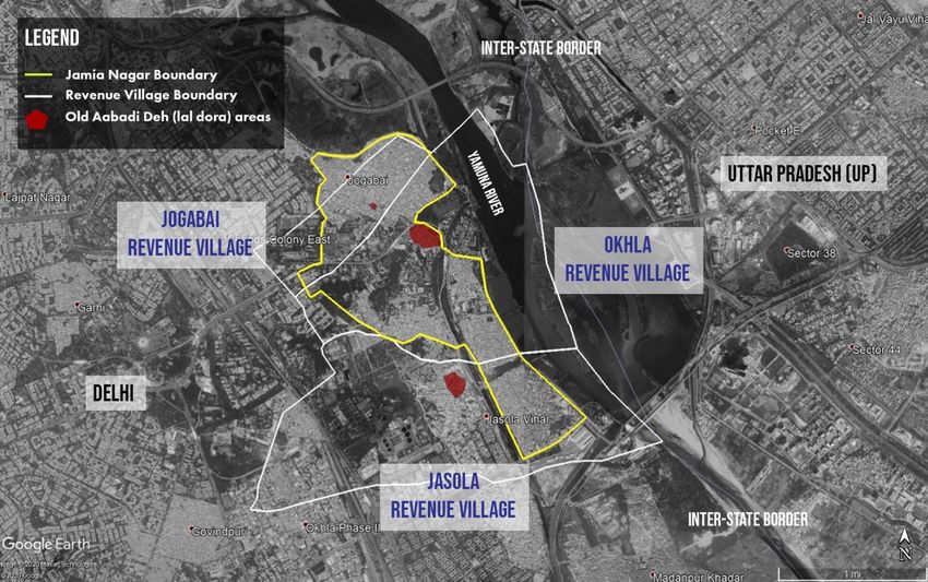
Abstract

Delhi is one of the most extensively studied urban areas globally. Yet, academic literature on the
question of “informality, as a mode of governance” (Roy 2005) has seldom paid attention to the
production of Muslim spaces in the city. Jamil (2017), in her scholarship on Muslim localities in
Delhi, introduces a rare perspective on how the urban Muslim is spatially organized within the
dominant ideology of urbanization in Delhi. This paper examines the history and politics of
(un)plannability to understand the production of Muslim colonies (focusing on Jamia Nagar) in
the context of neoliberalization in Delhi and the rise of Hindu nationalism in India. The paper
follows the changing body of the state to explain the political rationality of “exclusion” (Agamben
2005, Ong 2006), which does not always follow the logic of neoliberal governmentality. This
paper argues that the formation of Muslim neighbourhoods as the ‘enemy within’ is taking place
under state powers that pursue anti-Muslim policies on one hand and neoliberal urban expansion
on the other. I highlight the conditions of use and exchange of land that facilitate the blurring of
boundaries between state and society in Muslim colonies. Here, I pay particular attention to the
various ‘democratic’ processes that create informality through large-scale urban land acquisition
and regularization of the ‘unauthorized’. This research contributes to Jamil’s (2017) work by
highlighting how the racialized Muslim space is re-produced through its exclusion. It does so by
integrating spatial analysis with traditional archival materials and oral histories. The
territorialized control of Muslims and the criminalization of their spatial politics have led to the
solidification of a new racial order within Indian cities, where financialization of land is taking
place within a niche market, determined by the ‘Muslim value’. The spatial analysis undertaken in
this study highlights the practices of slow violence within urban planning and questions the ways
in which the tentacles of the criminal justice system and prison industrial complex have converged
on the lives of territorialized urban Muslims in India.

                                                                                                       ii
Foreword: Relationship of Paper to the Plan of Study

The ‘area of concentration’ in my Plan of Study is focused on the planning practices under the
private property regime. This includes examining the modes of land governance and
financialization adopted by local urban bodies, motivations for regional economic development,
and citizens’ claims and contestations in the production of urban space. Some of the learning
objectives outlined in the Plan of Study, which I have incorporated within the Major Paper, are
as follows:

Learning Objective 1.1 To develop a good knowledge of land and property rights in order to
understand their relationship and impacts on land use planning undertaken by the state.

Learning Objective 1.2 To acquire the skills required to study the role of the state in
regularising land markets and its partnership with private capital in capturing the value
produced out of redeveloped land.

Learning Objective 2.1 To study the legacies of colonialism in neo-liberal state practices to
understand the ways in which planning plays a key role in capital (re)accumulation.

Learning Objective 2.2 To acquire a good knowledge of the evolving role of key actors and
institutions in urban development in order to understand the limits of democracy in a
city/nation building project.

Learning Objective 2.3 To observe various forms of governance at play in the management and
use of urban spaces in order to understand the formal and informal relationships necessary to
sustain dominant planning practices.

Learning Objective 3.1 To situate the important role of socio-economic unrests in policy design
to critically understand the grounded politics of identity and place.

Learning Objective 3.2 To investigate the role of the capitalist class and their control over land
to understand their influence over planning legislation and policy making.

                                                                                                     iii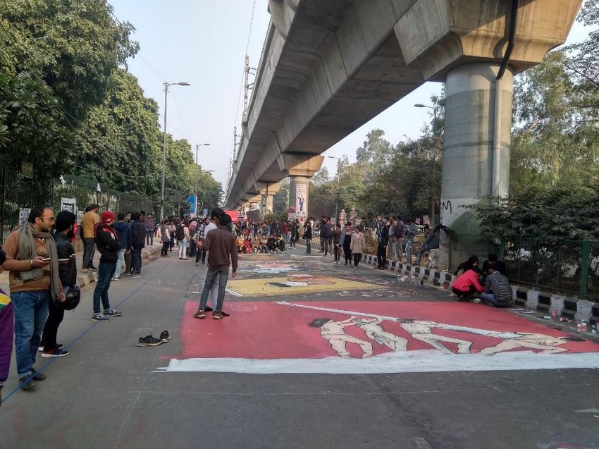
This Major Paper with the aim of understanding the history and politics behind the production
of Muslims spaces through their controlled exclusion from neoliberal planning practices lends
itself as a case study to my overall Area of Concentration. As one of the largest metropolitan
areas in the Global South, Delhi provides us a window into the changing relationships between
state and capital in shaping the contested development processes within our cities (Learning
Objectives 3.1 and 3.2). Delhi state’s evolution from a revenue collector, to an infrastructure
improvement body, to a facilitator of urban amenities and finally a manager of inequalities in
the city, is a good avenue to understand various methods of governance (Learning Objective
2.3). Moreover, a study of the history of land consolidation on caste and religious lines in Delhi,
reveals its embeddedness in colonial practices of planning for the purposes of making its
population more governable (Learning Objective 2.1and 2.2). By focusing on the formation of
Muslim colonies as the “enemy within”, the paper seeks to reveal the practices of a state which
pursues anti-Muslim policies on one hand, and neoliberal urban expansion on the other
(Learning Objective 1.1 and 1.2).

The paper, therefore, lies at the intersection of urban politics and neoliberal policy-making as it
explores the spatial politics of different classes of Muslim neighbourhoods in Jamia Nagar,
Delhi. This spatial analysis of planning and policy-making, which goes against the conventional
logics of capitalist development, is therefore essential to understanding the various practices of
citizenship in India.

                                                                                                  iv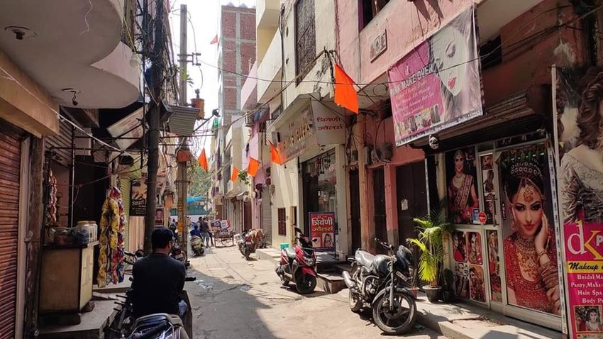
Acknowledgements

Writing this Major Paper and finishing the MES degree might go down as one of the most
confounding things I have done so far. To see it finally complete, fills me with so much gratitude
for everyone who has helped along the way. The length of this acknowledgement is
conservative by all measures.

To my sister, parents, and the rest of the family in Delhi and elsewhere. I can only wish I could
be with you, to share the grief and rage we all feel right now. Thank you for always being the
anchor, and for sharing your thoughts on the small and big things happening around us. I take
immense pride in all the ways my family (especially my mother) contributes towards taking care
of each other and the community at large. Most of all, my sister amazes me every day, with her
strong instincts and deep understanding of everyday politics.

Dr Abidin Kusno, thankyou for literally being the best supervisor. Your kindness and interest in
my research, schoolwork, and overall wellbeing has been the biggest source of motivation.
During the hardest of times, you always had a way of making me believe that my opinions were
worth sharing, and that writing them down wasn’t the worst idea out there.

To Dr Liette Gilbert, I owe the biggest thank you. Not only did you always take out the time to
help me navigate all university and immigration bureaucracies, but you always did it like it was
no big deal. You stabilize the life of your students, in an otherwise destabilizing academic world.
It would not be a stretch to say, that you have taught so many academicians how to care.

Deepika Jha, my brilliant supervisor during the 5 months research and fieldwork at IIHS in 2018.
Thank you for frequently steering me in the right direction, and helping me compile my
thoughts during our weekly check-ins. You gave me so much space to explore, and supported
all my curiosities, large or small. But most of all, thank you for helping me figure out that my
entry point into all questions of space and power was through studying land.

With great fondness, I reflect on the learnings and collaborative work with Dr Luisa Sotomayor.
As one of the many planning students under your care, I got a glimpse of what an
interdependent academic community might look like. As your GA, I saw the amount of

                                                                                                    v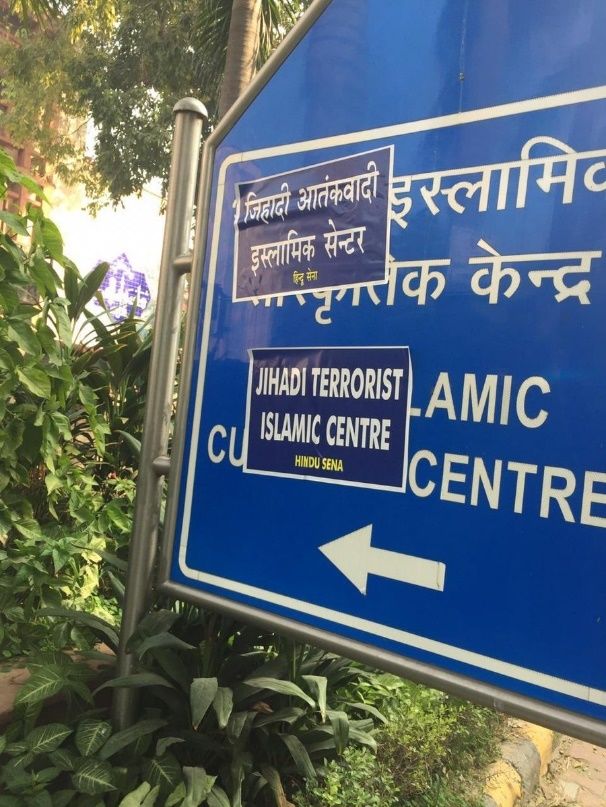
thoughtfulness and dedication required to build one. So many of my classes have helped me
understand the importance of being political while doing theory, for which I am extremely
thankful to Ranu Basu, Jin Haritaworn, Anna Zalik and Stefan Kipfer. I cherish all our discussions
within and outside the classroom, and hope that there will be many more.

With my friends, I know I have found the goldmine of all things bright and beautiful. Everyone
needs a Yasir in their life, and I am so glad I met mine when I couldn’t tell the difference
between an architectural model and a manicured piece of thermocol. You made sure I never
missed on any critical reading or thoughtful discussion, and I would be in denial if I don’t
acknowledge your part in my intellectual growth. Sonali, thank you for opening your home for
me, every time I grew weary of working on the same desk everyday. Together with Surbhi and
Lil’bear all weeks seem easier and outings funnier.

Pragya, knowing that you’re always there in the next room is the biggest comfort possible. You
have been there for every rant, meltdown, and of course for all things nefarious. Please know
that I am there for your academic/life woes as much as you have been there for mine.
Chanshri, your omnipresence on my screen is not something I take for granted. You have built a
support circle I never knew was possible. And taught me that when we share our troubles, we
are also sharing our strengths. To imagine writing this paper without your time management,
thoughtful inputs, and occasional attempts at exercise (ooh yeh), seems either impossible or
too painful. Harshita, nobody has believed in my work as much as you have. And that’s
probably because you know and feel the weight that comes with reading, writing, and
researching topics too close to our hearts and homes. Thank you for helping me understand
that collective mourning and reflection on our deepest discomforts are the essential first steps
to any organizing work.

Reema, Pallab, Fatin, Divyani, Arsalan, Vrashali, Maarif, Andy, Zainab, Anam, Fahad, and all my
friends close and afar, our conversations mean the world to me. Samar, thank you for having
me over during school breaks, and understanding that chess is more fun without the theory.

                                                                                                  vi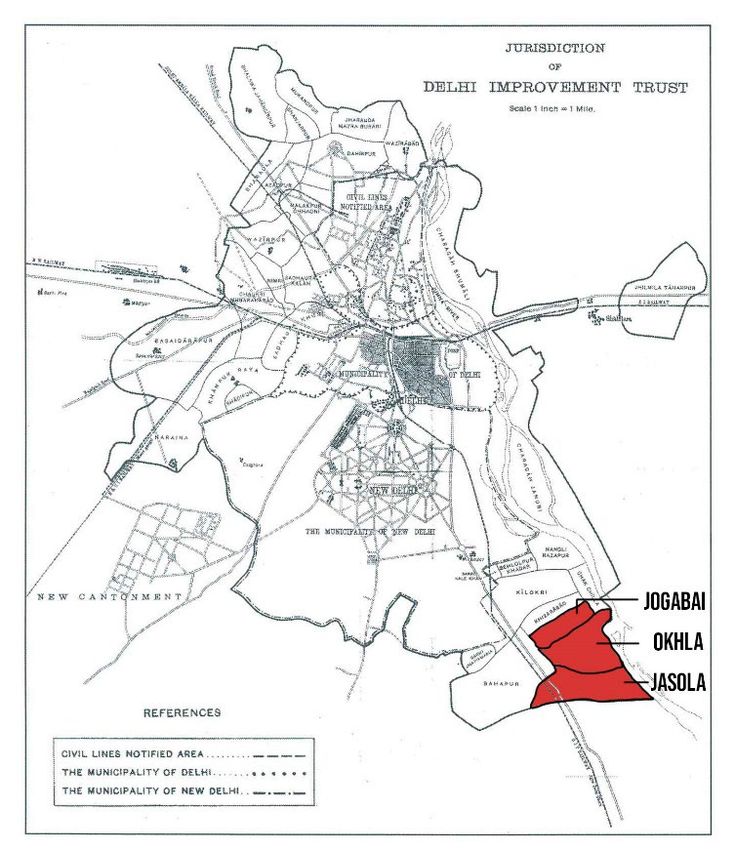
Table of Contents

Glossary of Terms ......................................................................................................................... 1

List of Figures ................................................................................................................................ 4

Chapter 1: Introduction ................................................................................................................ 5
   Conceptual Framework ............................................................................................................. 7

Chapter 2: Social Relations – Spatial Relations .......................................................................... 12
   Land Reforms and Growth Coalitions in India ......................................................................... 12
   Spatial Expansion and Urbanization in Delhi ........................................................................... 14

Chapter 3: Delhi’s Institutional History ...................................................................................... 16
   State, Revenue and Land ........................................................................................................ 18
   Institutionalized Expansion of Urban Delhi ............................................................................ 19
   ‘Failure’ of Institutionalized Planning? .................................................................................... 21

Chapter 4: Muslim Colonies in Delhi .......................................................................................... 27
   Methodology ......................................................................................................................... 28
   Land Acquisitions and Subsequent Illegalization .................................................................... 29
   Shifting Illegalities.................................................................................................................... 35

Chapter 5: Conclusion ................................................................................................................ 39
   The Enemy Within .................................................................................................................. 40
   Criminalizing Space ................................................................................................................. 42

References .................................................................................................................................. 46

                                                                                                                                              vii
Glossary of Terms

Aabadi Deh      Inhabited, non-agricultural areas within rural villages that were usually
                assigned a single Khasra (plot) number. Land records inside Aabadi Deh are
                not maintained by the Revenue department since revenue was only
                collected from agricultural plots. Houses or buildings inside an Aabadi Deh
                are usually assigned a property number. Aabadi Deh is not necessarily the
                same as older settlements in a village.

Benami (No-     A parcel of land which is purchased and registered in someone else’s name,
name) Land      and for which the real owner remains unidentified. These kinds of records
                were created to escape land ceiling provisions after the Land Reforms Act,
                1954, and Urban Land Ceiling and Regulation Act, 1976. More recently,
                Benami transactions have become a way to buy flats assigned only for
                lower income categories. Rent or any other income in cash or kind is
                controlled by the real (officially unidentified) owner.

Chakbandi       Chakbandi is a process of consolidation and rearrangement of land parcels
                in a revenue village so that each owner has contiguous parcels of land.

Mussavi Map     A field map and register of the revenue villages indicating its boundary and
                land parcels with their respective Khasra (land parcel) numbers. Mussavi is
                the original hand drafted copy prepared for each village.

Khasra Number   Land Parcel identification number in the Mussavi Map. This number is
                expected to be unique within a revenue village, for revenue purposes.
                Later used for urban land record keeping and subdivision.

Lal Dora        Original settlement boundary of a rural village as per the revenue records.
                This boundary was usually marked in red in the revenue village map (hence
                the name lal dora).

                                                                                              1
Land Reforms      Umbrella Term for tenancy reforms, including ‘land to the tiller’, land
                  ceiling regulations, and zamindari abolition. Under the Delhi land Reforms
                  Act of 1954, Section 33: No agricultural landowner shall have the right to
                  transfer by sale or gift, where as a result of that transaction, the landowner
                  is left with less than 8 acres of land in the Union Territory of Delhi. Under
                  Section 81: A landowner or tenant farmer shall be liable to eviction for
                  using land for any purpose other than a purpose connected to agriculture,
                  horticulture, or animal husbandry.

Patwari           A village accountant or registrar of the local authority who maintains the
                  ownership records and is also responsible for the collection of land taxes
                  for the area under their jurisdiction.

Residents         RWA is an association that represents the interests of the residents of a
Welfare           specific urban or suburban locality. Membership is typically voluntary;
Association       leadership is elected and subscription fee to join and continue the
(RWA)             membership with the association is compulsory. RWAs are registered
                  under the Societies Registration Act of 1860. RWAs are not official organs
                  of government, and even unauthorized colonies, slum designated areas
                  and other “unplanned” settlement types can form RWAs to represent
                  citizen interests.

Revenue Village   A revenue village is a small administrative region introduced during the
                  British Indian administration for the purpose of revenue collection. A
                  revenue village typically has numerous Khasras (land parcels) within it,
                  including the Aabadi Deh, extended Aabadi area and agricultural lands.

State             Term used throughout the paper to refer to the overarching government
                  establishment of political leaders, police, judiciary, upper/mid level
                  bureaucratic functionaries and middlemen with political clout.

                                                                                                  2
State               Term used to refer to the country subdivision in a federal form of
Government          government. In India, the state governments are the level of governments
                    below the Government of India (aka Central Government).

Unauthorized        One of the seven “unplanned” settlement types designated by the
Colonies (UACs)     Government of National Capital Territory of Delhi (GNCTD). These colonies
                    could be built in contradiction of any to the following (i) Zoning Regulations
                    as per the Delhi’s Master Plans (for 1962, 2001, 2021), (ii) illegally
                    subdivided land as per Section 33 of Delhi Land Reforms Act, 1954 or (iii) In
                    the absence of Land Use Change for the agricultural land on which the
                    settlement is built.

Regularization of   In recent years, the Delhi State government has undertaken a range of
Unauthorized        efforts to ‘regularize’ UACs and carry them across the line to full legitimacy.
Colonies            Post-regularization an UAC can transfer land and property legally and pay
                    the required stamp duty. Regularization can also mean access to more
                    service provision by government and financial institutions.

Urban Village       Rural revenue villages which have been declared ‘Urban’ under Section 507
                    of the Delhi Municipal Corporation Act, 1957 for the purpose of expansion
                    of Delhi.

                                                                                                 3
List of Figures
Fig 1: Patterns of Capital Formation in India, by sector (1970-2002) …………………………..…………. 8
Map 1: Boundary of Jamia Nagar overlayed on the previous revenue villages of Okhla, Jogabai
and Jasola………………………………………………………………………………………………………………..……………… 7
Map 2: Spatial Expansion of Urbanized Zones in Delhi (1950-1997) ……………………………..……….16
Map 3: Sample of layout plans submitted by Resident Welfare Associations (RWAs) …..……... 24
Map 4: Map showing Jurisdiction of Delhi Improvement Trust………………………………………..…….29
Map 5: A hand drawn map of the Okhla Revenue Village from 1965 ………………………..…………. 31
Image 1 & 2: Excerpts from a regularization application submitted by RWAs………….…………… 25
Image 3 & 4: Internal residential lanes in Abul Fazal in Jamia Nagar and Seelampur, a
resettlement colony in North-East Delhi …………………………………………………………………….……….. 38
Image 5: Posters put up by the armed right-wing organization Hindu Sena (Hindu Army) on sign
boards of important Islamic Institutions in Delhi…………………………………………………………………. 39
Image 6: Saffron Flags separating Hindu households from Muslim ‘enemy properties’ ………. 43
Image 7: Shaheen Bagh 24X7 occupation of Kalindi National Highway…………………………….……45
Image 8 & 9: Occupation of Maulana Muhammad Ali Road, by Jamia Millia Islamia students 45
Table 1: History of failed land acquisition or absence of land use change as per Delhi Master
Plans to explain the ‘unauthorized’ status of different neighbourhoods in Jamia Nagar………. 32
4Chapter 1: Introduction
While growing up, every year the roads that led to our house in Jamia Nagar, Delhi would fall
into worse and worse condition and the strong markers of a Muslim ‘ghetto’ became even
more evident. The scale of the uneven development between Jamia Nagar and the rest of
South-East Delhi was too stark to be ignored. Even residents of Jamia Nagar often talked of
moving out to some of the newer residential constructions in nearby areas of Sukhdev Vihar,
Jasola or Noida. Clearly there was something different about Muslim colonies 1 that prevented
them from developing in the same manner as the rest of Delhi.
My understanding of the neighbourhood was further complicated after learning that the house
belonged to our family, but not the land 2 on which it stood. Over the years as conversations
around becoming ‘legal’ grew, I never quite understood why we were ‘not legal’ to begin with?
How this unusual arrangement of ownership was even possible? It is only now that I
understand that all residential colonies in Jamia Nagar, while being occupied and developed
strongly on class lines, have one thing in common - they are all “unauthorized developments 3”
in the eyes of the state.
I was always most at ease when at home, but as I grew older there was always some underlying
shame in disclosing my address to new people I encountered. People who lived in other parts
of Delhi could identify Jamia Nagar as a “Muslim colony” and attached ever intensifying social
and politically charged stereotypes to it (Baruah 2019, also explored further in chapter 4). This
led me to the question that undergirds my research: How do shame and belonging come to
terms with each other, especially when the identities in question are related to neighbourhood
and community? As I began building a relationship with the social space around me, questions
1
The term “Muslim Colonies” is colloquially used to refer to various clusters of Muslim neighborhoods in Delhi.
These include but are not restricted to Jamia Nagar in South-East Delhi; Seelampur, Welcome and other Trans-
Yamuna rehabilitation colonies in North-East Delhi; Old Delhi or Shahjahanabad; and Taj Enclave in East Delhi.
2
No proof of permission to use land (freehold or leasehold)
3
One of the seven “unplanned” settlement types designated by the Government of National Capital Territory of
Delhi (GNCTD). These settlements are often either built in ‘contradiction’ to the Delhi Master Plans. Example:
developed without land use change for previous agricultural lands or been subdivided without following the
policies outlined in the Delhi Land Reforms Act of 1954.
5of power and history became the basis of all inquiries. How do households in Jamia Nagar prove
their de facto ownership? Why do we pay property tax when we don't have clear ownership?
Who cleans our streets when there is a Municipal Corporation of Delhi (MCD) sign board at the
entry of the colony that says “MCD limit ends here”? And if the “MCD limit ends here”, then why
are we still voting in municipal elections?
Drawing from these questions of why my neighbourhood looks and functions the way it does,
this paper contributes to the understanding of the formation and position of Muslim colonies
within the politics of land acquisition and regularization of the ‘unplanned’. Through the lenses
of land ownership and use, I make connections between the roles played by various state
planning institutions and the intermediaries between the state and society, as they navigate
governance, investment, and development of urban lands in Delhi.
The Delhi that I am interested in focusing on, is composed of the land revenue villages of Okhla,
Jasola and Jogabai (present day Jamia Nagar) that were brought into the urban sphere between
1905-1911 during the formation years of New Delhi as the new British administrative capital. I
look at the evolution of the state - from a revenue collector, to an infrastructure improvement
body, to a facilitator of urban amenities and finally a manager of inequalities in the city. My
focus is on highlighting the conditions of use and exchange of land which facilitate the blurring
of boundaries between state and society in Muslim colonies where various “democratic”
processes are imagined, reworked, and resisted.
However, I have paid particular attention to not contribute to the further revelation of the
processes and forms of passive resistance undertaken individually or collectively by the
residents of these colonies. Theorizations on processes taking place within a bounded informal
space carry a huge risk of exposing the ways in which socially criminalized communities occupy
places of living and livelihood in our increasingly violent cities. Also, such theorizations often
dangerously fall into the DeSotian fetishization of self-responsibility which further enables
neoliberal states to decentralize and privatize urban governance.
6Map 1: Boundary of Jamia Nagar overlayed on the previous revenue villages of Okhla, Jogabai
and Jasola. Also highlighted in red are the old rural settlement areas – Aabadi Deh (also known
as lal doras in land record keeping documents). Source: Spatial data compiled from village maps
(C-DAC n.d.).
Conceptual Framework
Growth of residential, commercial and institutional areas within Delhi’s unauthorized colonies,
while being direct products of Delhi’s approach to land acquisition and urban development
since the early 1900s, is also reflective of a particular history of neoliberal policy experiments in
the country. Brenner and Theodore (2002) and Peck (2013) describe these linkages between
localized histories, institutional legacies and neoliberal policy frameworks as “actually existing
neoliberalization”, which produce uneven and path-dependent urbanisms across various socio-
economic geographies. Arguing against the “dangerously productive myth” of neoliberal
restructuring as a form of hands-off governance, Peck et al. (2009) explains how new forms of
state intervention have been created to simultaneously dismantle collectivist and distributionist
welfare systems, while strengthening market rule.
7Kohli (2006) when discussing the industrialization processes in India, South Korea and Brazil
during the 1980s, highlights that these highly interventionist states have undertaken economic
growth schemes which “ruthlessly supported capitalists, repressed labour and mobilised
economic nationalism to provide social glue” (p.1252). After getting re-elected, post the Indian
Emergency (1975-77), Indira Gandhi abandoned previous redistributive national level policies to
make way for pro-business, growth-oriented strategies to favour private investment (Virmani
2004). By scrapping legislations like the Monopolies and Restrictive Trade Practices Act (MRTP),
offering major tax subsidies, loosening industrial licensing controls, opening up to foreign
collaborations in the management of public sector enterprises and discouraging labour strikes
and activism through special legislations, the Congress government created a charged anti-
labour and “growth first” atmosphere (Kohli 2006).
Fig 1: Patterns of Capital Formation in India, by sector (1970-2002). Graph showing that the
GDP growth in 1980s was fuelled both by public, and private corporate and household (home
based businesses) sectors. In the 1990s however, public investments declined with a growth in
variety of private investments. Source: Kohli (2006a)
8By mid 1980s the Government of India had begun to disinvest from the state-owned Public
Sector Undertakings (PSUs) through privatization and partial transfer of ownership to private
industrialists (Makhija 2006). Almost a decade before the liberalisation of the Indian economy
in 1991 (see Fig 1), the Indian state had already departed from its previously centrist
(convenient socialism) ideologies to become a right-leaning interventionist state that distinctly
supported the consolidation of power amongst the ruling elites.
The Washington Consensus on development during the 1980s and 1990s prescribed a market
of free players that would take their capital to undeveloped geographies in search of higher
returns, which would in turn promote competitiveness between regions and lead to further
efficient allocations of resources. Rodrick and Subramanian (2004) distinguish this “pro-market”
strategy from a “pro-business” strategy which supports and enables established players and
geographical regions. With pro-business strategies already underway since the 1980s, the only
major change brought through the Liberalisation, Privatization and Globalization (LPG) reforms
of 1991 was India’s approach to foreign investment and trade. The LPG reforms also paved the
way for regional and national chambers of commerce to form close political ties with the Indian
bureaucracy, so much so that the 1993-94 national financial budget came to be popularly
known as the “Tarun Das” budget - after the prominent West Bengal industrialist and then
director of Confederation of Indian Industry (CII) (Kohli 2006b, p. 1362). By the 2000s, key policy
makers including Montek Singh Ahluwalia 4 and Manmohan Singh 5 were publicly endorsing
public-private-partnerships and inviting top industrialists to be a part of the decision making
process (ibid.). From Tarun Das to the current leadership of CII which includes CEOs of Tata,
Kotak and Bajaj Industries, these chambers of commerce continue to play a prominent role in
influencing policy making and spearheading pro-growth coalitions between business elites and
state officials (Confederation of Indian Industry n.d.). These alliances between the national
government under the current Bharatiya Janata Party (BJP) and prominent business elites are
directly reflected in the change in telecom policies during the launch of Mukesh Ambani’s JIO,
4
Ahluwalia served as the deputy chairman to the Planning Commission of India from 2004-2014, before which he
was a board member of the International Monetary Fund from 2001-2004
5
Singh was Finance Minister of India during 1991-1996 and was responsible for spearheading the liberalization
reforms in India during the 1990s. Singh was later served as the Prime Minister of India until 2014.
9through the restructuring and refinancing of public sector banks to prevent Anil Ambani from
sliding into “billionaire poverty”, and through the deregulation of environmental policies in
favour of Gautam Adani’s “green-washed” growth (see Srujana 2019 and Wadhwa 2020). The
most prominent however has been the growth of Baba Ramdev’s spiritual empire ‘Patanjali’,
with BJP’s Hindu nationalism. From pushing Patanjali products into all Kendriya Bhandar’s
(national government employees cooperative) retail shelves to serving its samples in the Indian
Parliament, BJP’s open favoritism towards business giants has been justified as - promotion of
Swadeshi (home-grown) products (Worth 2018).
The narrowing of the ruling alliance between the state and the capitalist class has had a twofold
impact – firstly, it increased the concentration of businesses in certain regional growth centres,
and secondly, it contributed to the rising discontent amongst the religious and caste majorities
in middle and lower income classes. Mobilization for electoral gains based on sometimes
tokenistic and often divisive ethnic and religious sensibilities has been especially evident after
the 1980s. The Congress paty's repressive politics to compensate for lack of material upliftment
of politically under-represented religious groups opened the space for the subsequent growth
of Bharatiya Janata Party (BJP)’s Hindutva politics. Regional growth centres like Hyderabad,
Bangalore and Delhi in particular, have seen increased social tensions on grounds of
distribution of urban development incentives within their peripheral regions (see Kennedy
2007, Mitra 2017, Pati 2019, and Dupont 2005).
Post 1991 economic reforms, consolidation and urbanization of previously agrarian land
became the foundational strategy to undertake the imagined development trajectory that
Indian cities had been prescribed. I argue that large scale land acquisition by the Delhi state,
was not just taking place in the peri-urban areas, but also being used as a tool to formally
include unauthorized urban villages like Okhla, Jasola and Jogabai into the governable land
regime. As discussed in detail in Chapter 3 and 4, these urban villages have a layered and
complex history of mixed-use residential colonies coming up on agricultural land which was
acquired (but never taken possession of) by the Delhi state, through large scale acquisition in
the 1990s for the purpose of “Urban Development of Delhi”.
10Gururani (2019), in her work on suburban Delhi, argues that in predominantly agrarian societies
like India, “the urban question is indeed also the agrarian question” (p.3). Complex micropolitics
of land, property and tenure offer researchers a valuable segue into understanding the
divergent trajectories of capitalist development within various regions in Delhi. Placing colonial
histories within post-independence consolidation of land by caste elites in Delhi (erstwhile
Punjab Province) produces a complex picture of the political economy of land and property
which Gururani (2019) terms as “agrarian urbanism”.
However, there lies a reasonable amount of difficulty in identifying and studying the presence
of “state” in these “agro-urban” areas, where local state power is so closely intertwined with
the political power of the landed classes. In a classical interpretation of the term, the state is
often understood to be the locus of authority which extends control over its masses through
various practices and institutions of the government (Fuller and Bénéï 2001). Through
documents of birth, marriage, death, citizenship, housing occupancy permissions, utilization of
public amenities and taxation - the state organizes and validates its citizens at every stage in
their lives. But when questions of power begin to reveal the hidden secrets and practices of
violence by the state, the unifying and sovereign concepts of the state begin to break down
(Tarlo 2003).
This paper, therefor, aims to find a way to answer the question: how can we study the state? To
begin this process, in the forthcoming chapters I trace resource flows, distributions, and
material or symbolic transactions to understand how ‘power of the state’ is mediated through
fixed bureaucratic structures, local institutions and agents between the state and society. This
mediation between key players, who have benefited from land consolidation in North India
(Punjab region in specific) of previously agricultural land into the peri-urban sphere, is traced in
the first half of the paper.
Chapter 2 looks at the interplay between social relations and spatial relations to understand
how growth coalitions between the political and caste elites have become a ‘common sense’
approach in the process of agrarian urbanization. It also problematizes the definition of
‘urbanization’ within Delhi’s urban-rural hinterlands.
11Chapter 3 then focuses on the particular land history of Delhi (erstwhile Punjab province) to
trace the evolving practices of private property development by the various land governance
and development institutions in the city. Here I use ‘zones of exception’ as a conceptual
framework, offered by Agamben (2005) and Ong (2006), to understand the impact of the
practices of land consolidation undertaken in the city.
Chapter 4 delves deeper into the development history of Muslim colonies in Delhi, with a focus
on Jamia Nagar, to understand the reproduction of space through the process of exclusion. I
conclude by drawing connections between the exclusion of Muslim spaces from neoliberal
development processes, and impact of criminalization of Muslim spaces in the public domain. I
offer an emancipatory reading of the spatial politics of Muslims (especially women) in imagining
spaces of liberation and radical politics within India.
12Chapter 2: Social Relations - Spatial Relations
This history of land consolidation and development in India is embedded in colonial practices of
planning, which specifically aimed to make the colonized population more governable. The
British Colonial Government, as well as the religious and caste elites in India understood how
“access to land” was the most powerful tool to produce and maintain dominance over large
populations (Srinivas 1986). As a punishment for its participation in the Revolt of 1857, the
Delhi District - previously a partially autonomous state within British ruled India - was
incorporated in 1858 within the Punjab Province directly under the British. With the inaction of
The Punjab Alienation of Land Act in 1900, the transfer of land ownership in the Punjab
Province was restricted to certain “agricultural tribes” only, which were represented by upper
caste families in the region (Cassan 2010). The membership to these agricultural tribes
restricted the rights to buy and sell land amongst other rights of uses. Cassan (ibid.) also
accurately observes that the British, post-1858, quickly realized that “understanding India
required understanding Caste” (p.7). The Punjab Alienation of Land Act, therefore, served the
dual purpose of reaffirming existing caste hierarchies that were intended to further socio-
economic disparities between social groups; and at the same time provided stability to the
British Empire by rewarding the loyalists to the Crown.
The development of caste hierarchy within Muslims in South Asia reveals how the spread of
Islam in the subcontinent did not lead to the eclipsing of caste in the region, rather it accepted
the caste society as a way to preserve authority and social prestige held by descendants of
Arab, Turkish, Afghan and Persian heritage. Gazetteer of the Delhi District in its chapter “Tribes
and Castes” uses the term “Chief Muhammadan Tribes” and confirms that farming land could
only be owned by “Sheikh, Syed, Pathan and Mughals” (Punjab Government 1884, p.68-72).
Land Reforms and Growth Coalitions in India
Land reforms in India carried out between 1950-1970 aimed at tenure reform, land ceiling and
distribution, and land to the tiller reforms. While the legislation and implementation of these
reforms was carried out at the state-level, the overall outcome of the reform further
13consolidated existing cast-class hierarchies stemming from the British landlord-based systems
of revenue collection and local power. Herring (1983) calls the land distribution policies in
various Indian states a “partially completed bourgeois revolution” which has consistently
reflected the interest of the ruling political regime and dominant castes. Thomas Metcalf in his
study on land reform implementation in Uttar Pradesh also noted that Muslim landlords with
smaller landholdings were particularly targeted and witnessed a substantial decline in economic
capital as compared to the Hindu landlords (Umar 2019).
Seasonal agricultural labourers, tenant farmers and sharecroppers have been massively
marginalised from the land reforms due to their positioning within the caste, religious and
regional divisions. In an analysis of land reforms undertaken in various states of India, Basu
(1990) argues that when combined with the national liberalization policies, these regional
reforms were pro-sectoral and aimed towards increasing agricultural assets, instead of being
pro-poor. Metcalf (1967) in his writings on the execution of the Zamindari Abolition Act 6, 1954
in Northern India observes that these reforms could not end poverty amongst the lower castes
which formed the bulk of the agricultural labourers and cultivators. The lower castes simply
became tenants of the state, in place of the zamindar (landlord) class.
Kjær (2009) in Governance and Urban Bureaucracy, points out the tension between “efficiency
and democracy” in a system of new public management adopted by the state. Indian State’s
focus on maximizing the utility of the built environment and economic efficiency has led to the
gradual shift of power in the hands of the “market”. However, the peri-urban land market
discussed in this paper does not work in isolation and is directly linked to the increase in land
rent for the caste-based growth coalitions active in the Delhi region. The other characteristic
sign of the “marketized” state, according to Kjær, is the use of performance indicators to design
policies and then use them to assess the output produced by those policies. The ‘market’ here
was used for the consolidation of power and wealth in the hands of already powerful caste and
class elites.
6
Land reform aimed at abolishing the landlord-based system of revenue collection which were set up by the
British Colonial Government.
14The urban growth coalitions (Molotch 1976) in Indian cities reflect a pattern of land, labour and
capital accumulation achieved in social formations that are founded and maintained on caste,
religion and gender hierarchies (Kozlowski 1980 and Pandey 2013). Bichler and Nitzan (2004) in
Dominant Capital and The New Wars, suggest that the notion of “accumulation” needs an
empirically grounded theorization. They argue that accumulation cannot be understood only as
a material term, but in fact is a representation of a dominant groups’ ability to financialize on its
socio-political power and their ability to convert growth coalitions as a ‘common sense’ method
of urban development.
In Delhi, the Punjab Land Alienation Act of 1900 led to the socio-political class solidification of
the Jats and Yadavs, both dominant land-owning agricultural tribes in the region. The Jat
political clout in the region further increased with their entry into farmers’ unions which played
a pivotal role in championing the ‘backward’ landowning community (Chakravarty-Kaul 1996).
Gujars, who were an agro-pastoral caste, were gradually pushed to less fertile arid and rocky
stretches within Delhi. However, after the passing of the first Delhi Master Plan in 1962, a new
focus on urbanization and land development did not link the exchange value of land with
agricultural productivity any longer. Arid and fallow land owned by Gujars became highly
desirable during the building of urban centres and highways (Gururani 2019). Gujars soon
entered the real estate market in Urban Delhi, along with Jats and Yadavs to formed the
dominant political class in the 1970s-80s. As observed later in the case of urban villages of
Jamia Nagar, the new non-Muslim capitalist class quickly moved out of the congested lal doras
(original settlement areas in rural villages) to settle in the planned colonies of Delhi.
Spatial Expansion and Urbanization in Delhi
The spatial expansion and patterns of settlement in Delhi are closely linked to the flows of
migration in the city. In the period between declaration of Delhi as the new capital of British
India in 1911 to Indian independence in 1947, the population of Delhi almost quadrupled from
238,000 to 900,000 (Dupont 2000). During the Indian partition, Delhi received about 470,000
refugees from the Punjab and Sindh regions, while about 320,000 Muslims left Delhi and
migrated to Pakistan. The population of Delhi reached about 1.4 million by 1951 (ibid.).
15The multi-directional spatial expansion of Delhi’s urban area doubled between 1941 to 1961 to
accommodate this drastic demographic expansion. Post 1981, population, and settlement
growth in the rural peripheries of Delhi was taking place at a much higher rate (9.6%) than its
urban core (3.8%).
However, the parts of Delhi that were still
considered as ‘rural villages’ as per the 1991
Census had more in common with urban
agglomerations than their rural
counterparts in India. With the ‘failure’ of
planning institutions in Delhi to respond to
the housing needs of the new urban-rural
populations, growth of unauthorized
colonies on previously agricultural land
began after the first Delhi Master Plan of
1962. This method of urbanizing in the rural
hinterlands of Delhi is what Roy (2005)
recognizes as production “unplannability”
by the state. Roy argues that informality as
Map 2: Spatial Expansion of Urbanized
a state of exception has become the Zones in Delhi (1950-1997). Source:
(Dupont 2000)
“formal order of urbanization” (p.147).
Socio-spatial relations as products of planning, and in response to planning techniques by the
Delhi state are discussed in detail in the subsequent chapters. Production of space, here, is
understood to be a reflection of the conflicts and tensions that arise from various social
interactions on the boundaries of state and society.
16Chapter 3: Delhi’s Institutional History
In 2018, a report on the ‘Situation Analysis of Property records in Delhi’ (IIHS 2018) concluded
that not only did Delhi not have a single custodian of land and property records for all of the
National Capital Territory, but also that there is no one record or format across the various
governance and planning typologies. This ambiguity in records and record keepers of Delhi
suggests that the slice of society that is in fact recorded and documented by the state, is not
representative of the actual activities taking place in the city. Which brings us to the question,
‘if it’s not the reality that is being documented then what actions are being taken based on the
part of our lives that is being documented’?
In a reflection on the slippage between ‘paper realities’ and ‘lived realities’, Tarlo (2001)
explains that the value in studying state records lies not so much in the statistics they produce,
but in the insights they provide about the state’s changing functions and priorities. An analysis
of Delhi’s records makes visible a history of violence in the form of dispossession and
displacement. The Economic Survey of Delhi 2008-09 switches between the two unrelated
metrics of legality of ownership and condition of housing, to state that only 23.7% of the
population in Delhi lives in “planned colonies”, with majority of the remaining population living
in areas categorised as “slum designated areas” – 19.1%, “JJ Clusters 7” – 14.8% and
“regularised-unauthorised colonies” – 12.7% (Government of Delhi 2009). The Economic Survey
of Delhi 2018-19, further simplifies this assessment by only mentioning the “number of these
settlement types” in Delhi and attempts to hide its continued failure to provide adequate
housing to Delhi residents by completely omitting the “percentage of population” statistics
(Government of Delhi 2019).
This section of the paper analyses the layers of history of land record keeping and the
development practices undertaken by various institutions of land governance in Delhi, to
explain - why typologies of land development tied to socio-spatial realties in Delhi produce
statistics like the one highlighted above by the Economic Survey of Delhi? Here I analyse the
7
Juggi Jhopri Clusters: hutments or small roughly built shelters
17colonial practices of land record keeping and distribution, before moving on to study existing
post-colonial institutions of planning in Delhi and how they have internalized these colonial
practices of land ownership and development.
State, Revenue and Land
The British Empire’s major interest in developing a system of land records was primarily for the
purpose of revenue collection. The British system of land administration and revenue collection
was strongly informed by the capitalist notions of the English Common Law which viewed land
as property and associated exchange value with land (Harris 2004). However, when confronted
with the complex rights of uses of land in the colony, the Government of British India realised
that it could not simply erase the existing terminologies of land use and revenue collection in
Delhi. This oriental empiricism led to a conceptual layering of meanings and practices
associated with lands like waqf and nazul, which continued to be referred as the same in
revenue records and judicial purposes (Pradhan and Lal 2019). The cultural values associated
with them, however, underwent considerable mutation due to land administration and change
in ownership titling system under the new Imperial administration. Making holdings or estates
waqf, for instance, meant endowing an estate onto family members for the continuance of
family honour and prestige. But by the end of the nineteenth century, the pressure of British
jurisprudence transformed the nature of waqf from familial to charitable endowments for
public or religious welfare (Kozlowski 1980b).
Agricultural land in British India fell under one of three the systems of revenue collection: (a)
zamindari or landlord-based system), (b) raiyatwari or individual cultivator-based system and
(c) mahalwari or village-based system. Delhi (under the Punjab Province) since 1857, came
under the mahalwari system where the village bodies jointly owned the village and were
responsible for land revenue from the Revenue Village. The composition of this village body,
however, was usually very homogenous and often consolidated in the hands of upper caste
families loyal to the crown (Banerjee and Iyer 2005). The British system of land revenue
collection thereby created a regime of private property ownership, which has since continued
to be owned and controlled by the upper caste families in Indian villages.
18These systems of revenue collection, as discussed by (Chakravarty-Kaul 1996) his book Common
Lands and Customary Law, marked the demolition of common property in the Punjab region
during the British period. Kaul argues that the British government established the political
assumption of village control in the hands of landowners, as they took the central stage in the
institution of agrarian land administration. Hence, the British system of land-revenue
administration directly contributed to the decline of joint control of common land resources
within villages and the rise of private property rights amongst land owning higher caste farming
families, which the author refers to as the ‘tragedy of the commons’ (Ibid., p.4). Kaul also
remarks how these practices reveal the intention of the Colonial state to ‘fix’ the nomad and
convert him into a cultivator. During this period, the state began large scale acquisition through
eminent domain, to become a major landowner. Acquisitions under “planned development of
Delhi” were undertaken to expand roads, railways, and canal networks for the urbanization of
Delhi. The colonial state here became the primary force behind the transformation of agrarian
land into urban land.
Institutionalized Expansion of Urban Delhi
In 1907-08, all village land outside the old walled city of Delhi was surveyed and underwent the
process of Chakbandi (village consolidation) to enhance the British government’s revenue
collection. Since the Britishers were concerned with collecting revenue only from agricultural
land, all village land inhabited by people (Aabadi) was circled as Aabadi Deh and left un-
surveyed. This spatial land record system identified the quality of soil based on its fertility for
cultivation to determine revenue collection rate, thus eliminating the need to officially
document any use or customary rights associated with a particular piece of land. In cases of
land acquisition by the state, ownership rights could be proved by producing land records from
the Revenue Department. However, claims to compensation by any tenant farmers or other
users of land was determined by a Patwari (land record keeper) of the Revenue Village, based
on the documents that non-owners were able to produce to prove their use rights.
Shortly after the consolidation of revenue villages into Delhi, in 1938, the Delhi Improvement
Trust (DIT) was formed on the recommendations of Arthur Parke Hume, who was
19commissioned in 1937 by the British State to assess the conditions of urban congestion and
poverty in Delhi (Legg 2006). Hume’s report presented a picture of crumbling infrastructure and
overcrowding in Delhi and suggested that residents be moved out of the walled city and
surrounding slum areas. Like Hume, Patrick Geddes also criticized the congestion and
unsanitary conditions in Delhi and proposed his own techniques of diagnostic survey and
conservative surgery to improve urban areas within imperial colonies. These “improvements”
to Delhi proposed between 1937-47 under DIT were never successfully realized, but in essence
sought a “material representation of a viable colonial modernity” (ibid., p.182). These imported
practices of ‘development’ that aimed to improve spatial planning, promote public sanitation
and make land parcels available for easy marketization by removing all ‘public nuisances’ and
‘health hazards’ in surrounding areas informed the first Master Plan of Delhi prepared by the
Delhi Development Authority in 1962.
73 years after Independence from the British Empire, Delhi Development Authority (formed in
1957), continues to use the same revenue maps as the starting point of all spatial land records
in Delhi. This uncertainty, in rights to land use and appropriate compensation in cases of
acquisition, continues to affect land-less occupants and users in these Urbanized Revenue
Villages of Delhi. For people owning property inside the Aabadi Deh (also known as Lal Dora
areas) there is no record keeping that can prove their claim to the land on which their property
is built. Proof of property ownership here can be shown by producing either utility bills,
property tax receipts or validation letters with property numbers from the village Tehsildar
(revenue officer).
Delhi Development Authority (DDA), formed under the Delhi Development Act of 1957, is often
referred to as the “successor of Delhi Improvement Trust (DIT)”. DDA inherited all properties of
DIT including all Nazul 8 lands and all 23 Nazul Revenue Estates owned by the DIT. In addition to
this, DDA is also responsible for managing all Ministry of Rehabilitation’s land, Land and
Development Office’s land, Urbanized Gaon Sabha (village body)’ land, and land acquired
8
Under the Mughal Administration, Nazul lands were Crown land under the Emperor. However, in current
terminology, it refers to land owned by local municipal authorities for development purposes.
20through acquisition that was never allotted for the intended “public purpose” – essentially
creating a huge land bank owned by DDA (Jolly 2010). This makes DDA, the biggest landowner
in Delhi, very much like the British Colonial State between 1857-1947.
Once a revenue village is declared ‘Urban’, under the Section 507 of the Delhi Municipal
Corporation Act of 1957, it is not governed by the Delhi Land Reforms Act of 1954 anymore.
Which amongst other administrative changes, also results in the withdrawal of the Revenue
Department’s responsibility to update land records. Non-maintenance of inventory of land
acquired by DDA has resulted in huge parcels of land scattered across the city that DDA has
never taken possession of. Many of these lands all across Delhi, allotted to DDA but never taken
possession, gradually have been taken over by original owners or land mafias, who fully aware
of the legal status of the land, have sold it on market prices to unsuspecting buyers. This
ambiguity is a result of using land records created for the “non-urban”, for “urban” planning
purposes. Further, records which do not show the actual use on these lands, have become one
of the major contributing factors behind entire stretches of neighbourhoods being
characterized as “unauthorized development”, as highlighted in the Economic Survey of Delhi
2008-09.
‘Failure’ of Institutionalized Planning?
Immediately after independence in 1947, Delhi Lease and Finance (DLF), a private developer
company started buying large parcels of agricultural land and developed them into elite
neighbourhoods throughout Delhi. DLF also held on to large chunks of land in anticipation of
future increase in land prices. DDA, in 1957, was hence formed as a response to DLF’s
speculative practices and entrusted with all publicly held land in the city (Ghertner 2010). The
first Master Plan of Delhi (MPD), prepared in 1962, allotted a quarter of all residentially zoned
land, owned by DDA, for the purpose of low-income housing for new migrants. DDA and its
private contractors secured migrant labourers from the neighbouring provinces of Uttar
Pradesh, Bihar, Rajasthan, Haryana, etc. As the first Master Plan was followed by a boom in the
construction sector, Delhi witnessed a huge influx of migrants from adjoining provinces, and
labour camps were created on vacant land close to construction sites which housed workers
21You can also read


