THE FACE OF DISASTERS 2019 - Beyond Response to Build a Sustainable Future - SEEDS India
←
→
Page content transcription
If your browser does not render page correctly, please read the page content below
THE FACE OF DISASTERS 2019
 Beyond Response to Build a Sustainable Future
Cover Image: Dealing with perpetual waterlogging in Gorakhpur, Uttar Pradesh, India, 2013

Authored by: Vijayalakshmi Viswanathan and Anshu Sharma
Design: Meghna Chawla and Siddharth Behl
Photographs: ©SEEDS / Sarika Gulati, Siddharth Behl
Citation: V.Viswanathan, A. Sharma (April 2019). The Face of Disasters 2019. New Delhi, India: SEEDS.

Acknowlegements
With sincere thanks for the valuable inputs from Dr. K.J. Anandha Kumar; Dr. M. Rajeevan; Nidhi Jamwal; Saritha
Thomas, Prof. Shakil Ahmad Romshoo and Dr. Vineet K. Gahalaut.
Preface
When we look at the outlook for disasters in India in the years ahead, clear challenges
appear. There are impending disasters which seem certain (like floods and drought).
There are also hotpots such as a large-scale earthquake that cannot be predicted but whose
risk looms large. In the longer term, the challenges are even more expansive. The impacts
of global warming and climate change threaten coastal communities with erosion; and the
third pole with transformation of the glaciers.
What these patterns show us is that we must put concerted attention on looking beyond
response. The patterns of the last few years must teach us to expect the unexpected.
What can we do differently to help reduce their impact, not just wait to respond once
a disaster strikes?
In parallel, there is a need to look at risks and vulnerabilities that aren’t yet technically
‘disasters’. Considering the experiences of the years gone by, there will be impacts that
continue to magnify under the radar – access to rapidly depleting water sources and the
growing heat stress being two of the most prominent.
The manner in which these disasters are manifesting themselves and the resulting impact
on communities is highly complex. For example, a single mega-disaster can wipe out
hard-won development gains, as happened with the 2015 Nepal earthquake. Recurrent
small-scale stresses keep the most marginalised families in a cycle of poverty. Climate
change impacts are only magnifying these vulnerabilities. For at-risk communities and
affected families, this interplay between dealing with poverty, climate stresses and natural
hazards doesn’t have clear distinctions. Each reinforces the other. This inter-connectedness
is also already being recognised globally in international frameworks such as the Sustainable
Development Goals and Paris Agreement.
Yet too often, action on disasters is still seen in isolation. This publication aims to look at
disasters’ broader face. For the risks of the future will be different from the risks of the past.
Recognising this and preparing for the unknown will be key to building a safer and more
sustainable world.
LOOKING BACK AT THE RISING TREND OF
                        EXTREME WEATHER EVENTS 1
                        The message emerging out of 2018 is loud and clear. Extreme weather events are on a rise
                        in India and we must plan and prepare for erratic weather patterns that are the new ‘normal’.
                        Almost every month of 2018 had one or the other ‘unprecedented’ weather events. We had
                        hailstorms, unseasonal rainfall, strong thunderstorms and lightning, floods and droughts,
                        long dry spells, cyclones, and both our monsoons — southwest and northeast — were
                        below normal. Also, average temperature over the country was ‘significantly above normal’,
                        making 2018 the sixth warmest year on record since 1901.2
                        Thus, it would be no exaggeration to term 2018 as a year of multiple disasters; both in terms
                        of ‘visible ones’ such as the catastrophic floods in Kerala in August, and ‘silent ones’ like an
                        unprecedented monsoon rainfall deficit of more than 20% in the northeast region of the
                        country.

                        Rising temperature
                        Last year started on a ‘dry’ note with very low winter precipitation in north India. There were
                        reports of acute drought in Kashmir due to “a record-breaking long dry spell”. Meanwhile,
                        the spring came early in the Himalayas as Rhododendron arboretum, a small evergreen
                        tree, started flowering in January, two to three months in advance. This was blamed on an
                        unusual warm spell and rise in temperature in the hills.
                        Rising temperature isn’t a one-off thing. Meteorological data analysed by the India
                        Meteorological Department (IMD) shows a trend of rising temperature in large parts of
                        the country. For instance, the IMD has carried out long-long-term assessment of climate
                        change in the country between 1951 and 2010’. State wise averaged annual mean maximum
                        temperature time series has shown increasing trends over many states of India, particularly
                        significant over Andaman and Nicobar, Andhra Pradesh, Arunachal Pradesh, Assam, Goa,
                        Gujarat, Himachal Pradesh, Jharkhand, Karnataka, Kerala, Lakshadweep, Madhya Pradesh,
                        Maharashtra, Manipur, Mizoram, Odisha, Rajasthan, Sikkim, Tamil Nadu and Uttarakhand.
                        The highest increase in annual mean maximum temperatures was observed over Himachal
                        Pradesh (+0.06ºC/year) followed by Goa (+0.04ºC/year), Manipur, Mizoram and Tamil Nadu
                        (+0.03ºC/year each).3
                        Similarly, state averaged annual mean minimum temperatures have shown significantly
                        increasing trends over Andhra Pradesh, Arunachal Pradesh, Assam, Bihar, Delhi, Gujarat,
                        Haryana, Kerala, Lakshadweep, Manipur, Meghalaya, Rajasthan, Sikkim, Tamil Nadu and
                        Tripura. The highest increase in annual mean minimum temperature was observed for Sikkim
                        (+0.07ºC/year) followed by Arunachal Pradesh, Bihar, Delhi, Gujarat, Manipur, Tamil Nadu
                        and Tripura (+0.02ºC/year each).4

                        Hailstorms
                        Early in 2018, Maharashtra, Chhattisgarh, Madhya Pradesh, Telangana and Uttar Pradesh were
                        hit by unseasonal rains and hailstorms that damaged standing rabi (winter) crops in over
                        4.76 lakh hectare area. Maharashtra is prone to hailstorms, as documented in a countrywide
                        analysis of hailstorms between 1985 and 2015 by the IMD Pune office.5 But, scientists at the
                        Met department point out that “from 2013, there is prolonged persistence of hailstorms in

4 | The Face of Disasters 2019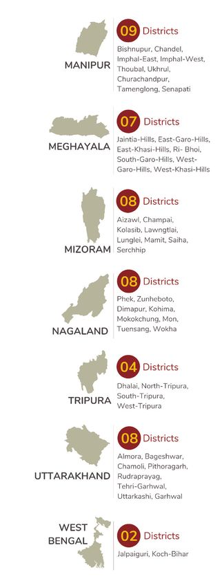
the state, causing extensive damage”. Hailstorms now affect larger area in the state over
several days. There are concerns over the increasing size of hail, too.
There are studies that link increase in hailstorm activity with the changes in the climate.
According to a 2010 study, ‘Climate change and hailstorm damage: Empirical evidence and
implications for agriculture and insurance’, “… hailstorm damage may increase in the future
if global warming leads to further temperature increase… Our estimates show that by 2050,
annual hailstorm damage to outdoor farming could increase by between 25% and 50%, with
considerably larger impacts on greenhouse horticulture in summer of more than 200%.” 6

Thunderstorms and lightning
After hailstorms, large parts of the country faced a series of extremely strong thunderstorms
and dust storms last year. A thunderstorm, mostly a short-duration phenomenon that
seldom lasts over two hours, is always accompanied by thunder and lightning, usually with
strong gusts of wind, heavy rain, and sometimes with hail.7 India recorded a total of 3,620
thunderstorms in 2014 and 5,536 in 2015.8 Genesis of thunderstorm is dependent on four
broad factors – intense heating, moisture availability, instability in the atmosphere, and a
trigger.
Last year, Down To Earth, a fortnightly magazine, documented how 44 intense
thunderstorms struck over 16 states killing 423 people, which was ‘unprecedented’.
Thunderstorms were accompanied by lightning strikes that destroyed properties and killed
people. Data of the National Crime Records Bureau shows the average number of people
dying of lightning strikes every year between 2006 and 2015 was about 50% higher than the
decade before. Scientists at Indian Institute of Tropical Meteorology, Pune have examined
satellite data between 1990 and 2013 and found a two to three percent increase in lightning
strikes in the country.
Experts have attributed the ‘above normal’ thunder activity over North West India last year
to the late western disturbances. As per the IMD, seven western disturbances passed over
the region within two months (April and May 2018) – including three intense ones in the first
half of May. This seems higher than usual as a 2017 study has documented an average of
two to three western disturbances a month across North West India in the summer months.9
Climate scientists say western disturbances used to be very active in the month of January
over North India. But, these seem to be getting pushed to the spring season. While there
isn’t enough past data to reach a definitive conclusion, this area of changing pattern of
western disturbances needs more research as it directly impacts our weather.
Apart from western disturbances, jet streams also impact our weather and may be linked
to increasing storms. Jet streams, or river-like currents of air, circulate in the upper levels of
the troposphere (30,000 feet). A jet stream exists because of the temperature difference
between the Poles and the tropical regions. Since the Arctic is warming at double the rate
of the rest of the world, this temperature difference is reducing, thereby affecting the jet
streams.
There are scientists who attribute increasing intensity of storms to the rising heat, too. For
instance, urban heat island is expected to have an impact on thunderstorms, as surface
temperatures have fluctuated over Indian cities because of land-use and land-cover
changes. This impacts the lower atmosphere and can influence the trigger mechanism of
thunderstorms.10

                                                                             The Face of Disasters 2019 | 5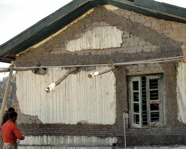
Monsoon: Redefining ‘normal’
                        The southwest monsoon in 2018, our main monsoon season (June to September) when the
                        entire country receives rainfall that supports agriculture, ended at a ‘below normal’ note.
                        That too after the IMD’s long-range forecast had predicted a ‘normal’ monsoon. All through
                        the four months of the southwest monsoon, there were prolonged dry spells affecting
                        kharif (summer) crop sowing and plant growth, and an almost dry September. By the end
                        of September, the northeast region of the country ended with a rainfall deficit of more than
                        20%. At an all India level, the southwest monsoon rainfall deficit was 9%, classified as ‘below
                        normal’.
                        However, meteorologists point out that the definition of ‘normal’ monsoon itself is tricky and
                        needs to be updated. ‘Normal’ rainfall is defined as 96%-104% of the long period average
                        (LPA), with a model error of plus or minus 5%. The LPA is the weighted average of rainfall
                        that India received in June-September from 1951 to 2000 and is pegged at 89 cm.
                        The IMD issues two long-range forecasts for the southwest monsoon. The first stage forecast
                        is issued in April and the second stage in early June. The second stage forecast covers the
                        four homogenous regions of the country —- Central India, Peninsular India, Eastern India and
                        Northwestern India —- and provides monthly monsoon rainfall forecast for the months from
                        June to September.
                        An analysis of the rainfall data of the past few years shows that several subdivisions received
                        deficient rainfall even in normal monsoon years. For instance, the country received 95%
                        rainfall of the LPA in 2017, but Vidarbha had 23% deficient rainfall. The East Madhya Pradesh
                        subdivision reported 24% less rainfall than normal, East Uttar Pradesh 28% shortfall and West
                        Uttar Pradesh 30% shortfall. The Haryana, Delhi and Chandigarh subdivision and the Punjab
                        subdivision also had deficient rainfall. On the other hand, the subdivisions of West Rajasthan
                        and Saurashtra and Kutch received excess rainfall.11

                        Droughts and floods
                        A ‘below normal’ monsoon rainfall last year has triggered drought in several states including
                        Bihar, Jharkhand, Karnataka, Maharashtra and parts of Andhra Pradesh, Gujarat and Rajasthan.
                        Maharashtra has sought drought-relief of Rs. 7,000 crore from the Centre. Karnataka and
                        Jharkhand, too, have asked for Rs. 2,434 crore and Rs. 819 crore drought relief, respectively.
                        What makes the matter worse is that the last year ended with a ‘below normal’ northeast
                        monsoon, too. Unlike the southwest monsoon, northeast monsoon (October to December)
                        brings rainfall to some meteorological subdivisions in south peninsula. In its January 16,
                        2019 ‘Statement on Climate in India during 2018’, the IMD pointed out that rainfall during
                        the northeast monsoon, between October and December, over the country had been
                        ‘substantially below normal’ – only 56% of the long-term average. And this, it said, was the
                        sixth lowest since 1901.
                        While almost half the country is facing drought, there were states that also faced floods last
                        year. The situation is grim in the northeast region where states such as Assam, Arunachal
                        Pradesh and Nagaland, which had faced floods, are now dealing with drought conditions.

6 | The Face of Disasters 2019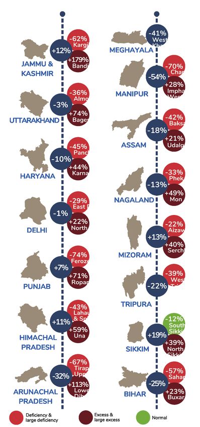
Cyclones
While several states were declared drought-affected, there were over 14 depressions and
four cyclones last year — Daye (September), Titli (October), Gaja (November) and Phethai
(December). Cyclone-battered Tamil Nadu (Gaja) and Andhra Pradesh (Titli) sought aid of
Rs. 15,000 crore and Rs. 1,200 crore, respectively.
There are several research studies that link changing climate to an increasing frequency of
intense tropical cyclones in the north Indian Ocean. Data of 122 years of tropical cyclone
frequency over the north Indian Ocean from 1877 to 1998 shows “there is indeed a trend
in the enhanced cyclogenesis during November and May”. There has been a two-fold
increase in the tropical cyclone frequency over the Bay of Bengal, a 17% increase in the
intensification rate of cyclonic disturbances to the cyclone stage and a 25% increase to
severe cyclone stage over the north Indian Ocean during November in the past 122 years,
the study notes.12
Analysis by Down To Earth suggests that extreme weather events have increased from just
one during 1900-1910 to 61 during 1971-80. And that number almost tripled to 162 during 2001-
2010.13
While no single extreme weather event can be attributed to climate change, it is also true
that the increased frequency and intensity of these extreme events are due to human-
induced climate change. Extreme rainfall, extreme heat, extreme thunderstorms, extreme
cold waves, extreme tropical storms are the new ‘normal’. And, we need adaptation
strategies and disaster response plans to face exigencies arising out of this new ‘normal’.
To address the increase in extreme weather events, the earth sciences ministry is
developing improved models for short-range weather forecasts, and a prediction system
for thunderstorms and lightning. It is further improving prediction of tropical cyclones by
developing a coupled (ocean-atmosphere) model. Also, 10 Doppler Weather Radars are
being installed this year over three hilly states of northwest India. Another 11 radars are
expected to be installed over the plains, including one in Mumbai by early 2020.
Trends in hazard patterns, vulnerabilities and capacities strongly indicate a complex road
ahead, wherein risk reduction efforts will need to be very substantially strengthened with
the use of improved governance, people’s participation and innovative processes and
technologies.

                                                                        The Face of Disasters 2019 | 7
Water and the
changing nature
of disaster risk
                        ‘New normals’ of rainfall variability
                        coupled with growing water usage are
                        bringing challenges of too much and
                        too little water, often in parallel

8 | The Face of Disasters 2019
The Face of Disasters 2019 | 9
The fury of foods while facing drought:
Averages are hiding the true story of changing variability

A
        ‘normal’ monsoon with floods and
        droughts? Monsoon forecasts
        are often blamed for showing
the wrong picture. The truth is that an
all-India ‘normal’ monsoon rainfall is
deceptive as it masks rainfall variability
not just among the 36 meteorological
subdivisions of the country, but within
them as well. These kind of forecasts
are meant for overall policy decisions,
not necessarily for action in specific

“
locations on the ground.

Day to day variability is very large in the
monsoon season. Also one place getting
flash floods doesn’t mean that ultimately
the seasonal rainfall will be more. With
global warming and climate change
aspects, this variability is increasing.
The last few years, what we have been
observing is that the number of wet days
are decreasing, but when it rains it rains
very heavily. That’s the difference. We
can have on the one hand, large excess
rainfall and at the same time large
deficient rainfall. So on both sides,
the extremes are increasing.

- Dr. M. Rajeevan, Secretary to the
Government of India, Ministry of Earth
Sciences
As rainfall variability grows more
extreme, there is also a need for people
to take the threat of flooding more
seriously. The Met Department is already
working on block level forecasting for
rainfall and an impact- based forecast
for floods is being developed to give
citizens a better picture of the possible
effects.

10 | The Face of Disasters 2019
“
Simply saying 20cm rain doesn’t help. 20cm rain in Cherrapunji and nothing will happen, it is like
an everyday affair. But the same 20cm rain in Bombay and Ahmedabad is very different. We need
impact based forecasting for floods, just like we have for cyclones, and we are already working on
framing this.”
- Dr. M. Rajeevan, Secretary to the Government of India, Ministry of Earth Sciences
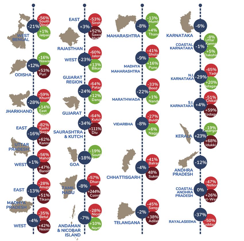
Departure from the normal rainfall
(June - September 2018)
Tracking the rainfall of districts within different meteorological subdivisions emphasises the danger of averages.
This shows the districts with the maximum departure from the long-term normal (in terms of too much and too little rain).
The data includes rainfall from the 1st of June to the 30th of September, 2018.
Based on meteorological subdivision data
The Face of Disasters 2019 | 11Groundwater: A disaster in the
making under the earth
In May 2018, Shimla, capital of the Himalayan state of
Himachal Pradesh, found its taps running dry. The crisis
was precipitated by a dry winter and long-term water
reduction, with drinking water supply falling to less than
50% of the requirement.14 Coming at the start of the peak
tourist season, there was a direct impact on the tourist
trade with hotels being forced to shut down. What was
less known is that the district of Shimla has declared
drought four times in the last 20 years, in 2000, 2002, 2005
and 2009.15
Shimla may have hit the headlines, but recharge reduction
is occurring across the country. There are an estimated
27 million wells across the country, with borewells
accounting for over 50% of these. Our usage is growing
and a groundwater crisis is rearing its head all over India.
Experts say any normal hydrograph of groundwater
should fluctuate – the water level in the month of April
will generally be low and by August the rains would
have brought it up near the surface. However, in many
urban areas, this kind of fluctuation is not occurring. The
withdrawal is so much that even after rainfall, there is no
major upswing.
Part of the problem is also that the growing extremes of
rainfall variability are not conducive to recharge patterns.
Heavy, short duration rainfall does not allow for water to
soak into the earth.
In Kerala, the flood water took away the river alluvial
soil along with the river runoff and thus has also affected
the aquifer material to some extent. So there was less
groundwater recharge during the flash floods in and
around the river. That is why, just after the floods, there
was a drought-like situation in some locations, when
people expected there to be more groundwater. Since
there is only a few metres of aquifer thickness, it needs
time to recharge. Water slowly trickles down and enters
the soil. So when you have an ideal situation where there
is slow rainfall over an extended period, you will have
better recharge. This was also the explanation given by
the Regional Director of CGWB in Kerala.
– Dr. K.J. Anandha Kumar, Scientist, National Hydrology
Project, Ministry of Water Resources, River Development &
Ganga Rejuvenation, Government of India
12 | The Face of Disasters 2019“
The quantity and quality of groundwater are inter-related. As the quantity of groundwater falls, quality is
also deteriorating. The TDS (Total Dissolved Solids) in the water gets concentrated because there is no way
to dilute it. Until there is a balance between the recharge and the discharge (withdrawal), we will continue to
have quality issues.
– Dr. K.J. Anandha Kumar, Scientist, National Hydrology Project, Ministry of Water Resources, River Development
& Ganga Rejuvenation, Government of India
Less water as well as poorer quality
In mid-2018, a Niti Aayog report warned that 600 million people
in India (almost half the population) are facing high to extreme
water stress. The states that were the lowest performers on
the Water Index, including Uttar Pradesh, Bihar, Rajasthan and
Haryana, are not just some of the most populous, but also
account for over a fifth of the agricultural output. What kind of
impact will this have on food security going forward?
At the same time, with nearly 70% of water being contaminated,
India is placed at 120 amongst 122 countries in the global water
quality index.16
The Face of Disasters 2019 | 13PLANNING FOR
WHAT YOU CAN’T SEE
Earthquake risk is looming large
under the radar, but are we prepared?
14 | The Face of Disasters 2019The Face of Disasters 2019 | 15
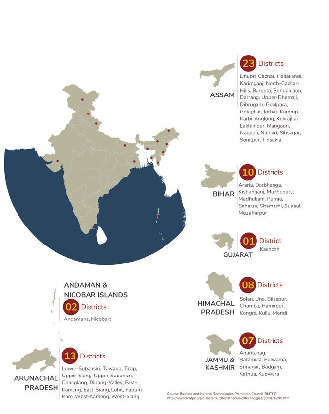
110 districts across India fall in Zone V
(Over 1/7th of the districts in the country)

16 | The Face of Disasters 2019
India’s high seismic vulnerability

O        ver 58% of India’s landmass is prone to earthquakes of
         moderate to very high intensity.
          Some seismologists argue that as new research
emerges, the zoning maps should be updated accordingly.
For example, micro-zoning maps that have been prepared
for cities like Bengaluru and Delhi show risk variations even
within the cities. With building codes and planning processes
linked to these, how effectively can these be implemented?
Seismic building codes that have already been instituted are
expensive and difficult to enforce. The seismic legislation and
regulation also seem to have failed to keep up with the influx
of city dwellers.
Even based on the zoning maps that we currently have in
place, 110 districts (over a seventh of India’s total districts) fall in
Zone 5, the current highest earthquake risk zone.
Over 17 million children study in over 157,000 schools across
these 110 districts.17
In fact, a Delhi Policy Group policy note states, “…an
earthquake in North India has the potential to cause damage
and casualties similar to a major nuclear strike in the country.”18
However, being prone to earthquakes is just one factor.
Seismic risk is multi-faceted. The place, season and time will
also influence the extent of damage. So far, fortunately, the
majority of large earthquakes have occurred during daytime
when families were awake and out of their houses. Similar
earthquakes occurring at night would have a very different
impact.
Secondary vulnerabilities also need further consideration.
The construction buildup in the Himalayas for example,
including water reservoirs, can trigger even greater damage
than the actual quake itself. An earthquake of the same
magnitude, but during monsoon season when the dams are
full, would present a very different scenario.
Population growth and building strength will also influence the
extent of loss. There’s a commonly used saying, ‘earthquakes
don’t kill people, buildings do.’ Research conducted by Prof.
Arya of Rorkee University in 1991 showed that a hypothetical
Kangra level earthquake occurring at that time in Kangra
would have resulted in 65,000 lives lost if all the houses were
without earthquake safety provisions. He predicted that the
‘trauma will be too great and the cost of emergency relief
will be exorbitant much beyond the capacity of the State and
even the country as a whole’.19

       Over 17 million children study in over 157,000
                    schools across these 110 districts.

                                               The Face of Disasters 2019 | 17
Waiting for the ‘big’ one
The 2015 Nepal earthquake was the last major event to occur in the
region, with a magnitude of 7.8. The destruction was unprecedented,
yet research by seismologists shows that the strain building up in the
different areas of the Himalayas still hasn’t been released. The ‘big
one’, an expected earthquake with magnitude of over 8.5 has yet to
occur.
“
Where is this likely to happen? The entire Himalayan belt is at high risk
and though predictions are challenging to make, studies show three
faults that do need concerted attention.
There is definitely a looming big New data inputs and evidence from both India and Nepal show that
one in the Himalayan belt. The the Garwal-Kumaon fault in the Uttarakhand region experienced
earthquakes we have seen so far, a large earthquake in 1344 CE. This was the last of the earthquakes
even the 2015 Nepal earthquake, with a rupture length and average slip consistent with magnitude
have not released the kind of of over 8.5 movement. In other words, over 770 years have passed
energy that is building up. since this area released that amount of pressure. This may make it
We don’t know when this will one of the most seismically vulnerable areas in the Himalayas. A
occur; but the more time that major earthquake in this region would also impact the adjoining
goes by, the more probable it Indo-Gangetic plains, where sediment is subject to liquefaction (soil
becomes. behaves more like a liquid), causing even greater damage.20
– Dr. Vineet Gahalaut, Seismologist
The second is the over 60 km-long Riasi fault in the Kashmir region,
part of the Main Himalayan Thrust. Historical earthquake record of the
past 1000 years, the high strain rates and partitioning of the slip make
seismologists see this a regionally important fault to monitor. The Riasi
fault, the thrust front or both pose even greater earthquake threats
than the 2005 7.6 magnitude earthquake that affected both sides of
Kashmir.21
The third is the region between Assam and Bhutan, also referred to
as the Assam Gap, which now includes Eastern Arunachal Pradesh.
While the 1950 Tibet-Assam earthquake was the last one in the region,
historical accounts show major earthquakes in 1697 and 1714. The
region remains fairly under-studied however. Some seismologists fear
that the strain accumulated might reactivate potential active faults
triggering large earthquakes in the future.22
18 | The Face of Disasters 2019“
Unlike a new house, retrofitting is like
doing surgery on a human body, opening
it up. There are always surprises waiting
for you. The World Bank’s 1993 Latur
Earthquake programme was the first
Retrofitting as a greener option?
As a whole, our building stock has to improve. India loses
about 1.2 million houses to disasters every year. Considering
this scale and magnitude, retrofitting is the greenest and
and only rehabilitation programme that most cost-effective option. Where possible, rules of thumb
had retrofitting as its integral part from and retrofitting technology must be promoted, both pre-
Day 1. The economics was that with the and post-disaster.
Rs.15,000 that people were getting, you Retrofitting has also proved its effectiveness in the past!
could build a 9ft x 9ft room or you could In the midst of so much sadness after the Gorkha
retrofit 500 sq. metres of your house. earthquake in Nepal in 2015, there was a small positive
But out of 250,000 house owners, only lesson. The 200-odd public schools which were rebuilt
about 3000 opted for retrofitting. There and retrofitted for earthquake resistance in an Asian
was this skepticism for retrofitting and Development Bank (ADB) pilot project effectively withstood
no one believed in it. the earthquake.23
– Rajendra Desai, National Centre for
Peoples’-Action in Disaster Preparedness
(NCPDP)
The Face of Disasters 2019 | 19‘Kaccha is Pucca and Pucca is Kaccha’:
The value of earth materials and indigenous technologies
When the Chamoli quake. However, this old unengineered reinforced
Earthquake hit on monument, with no ounce concrete homes. In Kashmir,
29 March, 1999, houses of cement or steel, stood it took some time but
across the village were strong. What the people in movements such as ‘Don’t
cracked beyond repair. the village gathered was Tear it Down’ managed
Families who had put all that the way the stones to convince governments
their savings into a beautiful, were laid in old times was to add indigenous
white and solid house had well worked out so that the technologies as an option to
their dreams wiped out. building shook but didn’t the reconstruction process.
However, what took suffer damage during an In the aftermath of the
everyone by surprise was earthquake. Their ancestors Sikkim earthquake in
the old stone temple. Said knew something that they 2011, similar observations
to be over 400 years old, it didn’t today. The technology were made about the
stood about one hundred they had imported from the performance of local Ikra
yards away without a single cities at a very high cost had structures as compared to
stone having been moved failed them. the Reinforced Concrete
from its place. The villagers In the aftermath of buildings. A study by IIT
had invested all their earthquakes in Kashmir in Kanpur states that about
resources and used the most 2005 and Nepal in 2015, 95,000 houses had been
advanced of technologies there were instant reactions fully, partially and severely
– cement, concrete and to local materials, with a damaged. Of the fully
a massive amount of view that concrete structures damaged buildings, only 4%
steel – even going to the were safer. Yet in both were of the traditional type,
extent of spending extra cases, what was seen was while about 20% followed
money. Yet their homes that well-built indigenous RC frame structures.24
counterpoint
were still shattered by the structures proved safer than
Dhaji-Dewari construction in Kashmir
The name ‘Dhajji Dewari’ literally translates into
‘patchwork quilt wall’. The name describes the
patterns of timber beams used in the frames of
such constructions, which are its distinguishing
feature. In the valley of Kashmir, the infill is usually
of brick made from fired or unfired clay. In the
mountainous regions of Kashmir extending into
Pakistan, the infill is commonly rubble stone. The
frame of each wall consists not only of vertical
studs, but also often of cross-members that
subdivide the masonry infill into smaller panels.
These impart strength and prevent the masonry
from collapsing out of the frame.
© Randolph Langenbach, www.traditional-is-modern.net
20 | The Face of Disasters 2019Taq construction in Ikra
Kashmir Ikra is a local construction practice based on timber
Taq construction is a bearing frames with bamboo mat infill plastered with mud or
wall masonry construction cement. Found in Assam, Sikkim and other parts of
with horizontal timber lacing the North East, the lightness and movement ability
embedded into the masonry of these buildings have proven to better withstand
to keep it from spreading earthquakes.
and cracking. It is usually
configured with a modular
layout of masonry piers and
window bays. These are tied
together with ladder-like
constructions of horizontal
timbers embedded in the
masonry walls at the base
of the structure above the
foundation, each floor level
and window lintel level.
Kath-Kona buildings in Himachal Pradesh
Structures constructed in the kath-kona or kath-ki-kuni style use alternating layers of timber
and dry stone masonry. Two timber beams, one on the inside and the other on the outside
are held together by joists at regular intervals. They are also connected with the beams
in adjoining walls at right angles. Walls in these buildings are built using alternate layers
of wood and masonry, usually stone and without the use of mortar. The Naggar fort of
Himachal Pradesh, near Manali, built using the same construction technique, has survived
for over 500 years.
Koti-Banal architecture in
Uttarakhand
Both the local dialects in the State of
Uttarakhand (Kumaoni and Garhwali) have
unique words to identify the four different
floors of a building. This is suggestive of
the fact that despite being located in an
earthquake sensitive region, it has a tradition
of constructing multi-storied houses. As early
as 1,000 years ago, the region evolved a
distinct earthquake-safe construction style
called Koti-Banal architecture. This style uses
elaborate procedures for site selection,
preparing the platform for raising the multi-
storied structure, as also for the detailing of
the entire structure that was constructed on
principles somewhat similar to that of framed
structures of modern times. Locally and then
abundantly available building material (wood
and stone) was judiciously used in these
structures. The structural designing suggests
that the architects responsible for designing
these buildings had fairly good idea of the
forces likely to act upon the structure during
an earthquake.
The Face of Disasters 2019 | 21NO DISASTER
IS ‘NATURAL’
Risks lurking under the radar slip through
the cracks because they don’t meet the
idea of a ‘natural disaster’
22 | The Face of Disasters 2019The Face of Disasters 2019 | 23
Vulnerabilities at the core

                                  H
                                         istorically, acts of nature have always been
                                         viewed as the wrath of God. In many
                                         communities across the world, they still
                                  hold a spiritual and mystical power. The use of
                                  ‘natural’ only emphasises notions of fatality and
                                  helplessness.
                                  An earthquake, a flood, a drought, a windstorm,
                                  a landslide. If you take any natural hazard and just
                                  change the demographic variables, the social
                                  context or the development patterns of the area,
                                  then you will have an entirely different story.
                                  The sustained use of the term ‘natural
                                  disasters’ gives the sense that this is somehow
                                  unavoidable. Nature has its patterns. The river
                                  may overflow its banks every year during
                                  the monsoon and the earth will shake where
                                  tectonic plates meet. The devastation caused,
                                  however, is not natural. It is about a simple
                                  formula. Hazard (the flood, earthquake, cyclone)
                                  + vulnerability = disaster. That vulnerability could
                                  be economic, environmental, physical, social
                                  or even physiological. In other words, an act
                                  of nature is only a potential danger. It is not a
                                  disaster in itself. By calling it ‘natural’, the entire
                                  implication of that vulnerability is taken away.
                                  More than anything else, it takes away an entire
                                  aspect of risk that is often human made and can
                                  be addressed.

                                  Daily stresses:‘Natural
                                  disasters’ hide other
                                  vulnerabilities
                                  The focus on well-known disasters and their
                                  technical definitions mean that risks that don’t
                                  meet this idea remain unaddressed. Many of
                                  these vulnerabilities lay in wait under the radar,
                                  a disaster in the making. At the same time, when
                                  a hazard does occur, the impact is multiplied
                                  manifold. This includes simple micro-level
                                  stresses such as blocked drains to hazards that
                                  are yet to make the notified list of disasters such
                                  as heat and air pollution.

24 | The Face of Disasters 2019
The Face of Disasters 2019 | 25
IN FOCUS

Struggling to breathe
Air pollution is being recognised as a critical health issue around the world and is the second largest cause
of disease in India. WHO’s safe air quality guideline states 10 micrograms per cubic metre of PM 2.5. India’s
minimum safe levels (60 micrograms per cubic metre) are already six times this limit, but only a few places in
the country meet this. The 2018 World Air Quality Report shows 22 of the top 30 polluted cities are in India,
with Gurugram topping the list.25
The State of Global Air report 2018 shows India has experienced the steepest increases in air pollution levels
since 2010. India and China together continue to see the maximum mortality burden due to PM2.5.26
Yet, myths around air pollution continue to persist. It will be critical to process that air pollution does not
occur just in winter, nor is it just urban. There are also multiple causes and addressing the complex interplay
between industry, transport, dust and biomass and waste burning will be critical to show results.27
Innovative steps in cities like Delhi, including the odd-even formula, truck timings and dust reduction action
that have been implemented have all focused on the outdoors. Yet the levels of indoor pollution are even
higher and put those who spend maximum time at home – housewives, the elderly and children – at
greatest risk. Over 560 million people in India were exposed to household air pollution in 2016.28

26 | The Face of Disasters 2019
IN FOCUS

Turn the cooling up!
2018 was the fourth warmest year on record globally; and the sixth warmest for India.
Heat has become a major issue across the world, but for those most vulnerable, it is a silent killer.
Between 2005 – 2015, 11,190 people lost their lives to heatstroke29 in India, and these are just official estimates.
Mortality is said to have declined in the last few years, but attributing deaths to heat is still not a clear cut
process. Adding to this, our bodies often feel hotter than the reported temperature. This is due to the
combination of temperature and relative humidity, also called the heat index. As humidity rises, so does the
risk of dehydration.
While both rural and urban areas face this issue, heat island effects in large densely populated cities are
amplifying the temperature. Heat trapped by roofs, pavement, and concrete structures raises the night
temperature, not allowing bodies to cool down. In the peak summer months, this creates a spike in indoor
temperatures which cause ‘Heat Stress’ (due to sick building syndrome). This is ultimately resulting in
increased casualties and various symptoms like skin rashes, reproductive disorders and heat stroke.
It’s also amplified as those who can afford it turn the cooling up, starting a vicious cycle of temperature rises
in micro zones. Walk around the back alley of any mall, office building or residential neighbourhood at the
peak of summer and the exhausts of the air conditioners automatically raise the temperature.
The impact of heat exposure also goes much broader, affecting productivity, earning potential and having
long-term consequences on health and cognitive ability. Children’s learning ability drops exponentially, and
worker absences take a sharp upward turn. India lost nearly 75,000 million hours of labour in 2017, up from
about 43,000 million hours lost in 2000; the majority in the agricultural sector, but with impact on industrial
and service sectors as well.30

                                                                                             The Face of Disasters 2019 | 27
THE COMPLEXITY
OF DISASTER IMPACT
Beyond ‘damages’, the long-term and
uncaptured impacts have life-changing
consequences for affected communities
28 | The Face of Disasters 2019The Face of Disasters 2019 | 29
Understanding multiple
                                  causes

                                  C
                                         omplexity begins with the multiple causes
                                         of damage. The Tohuku earthquake which
                                         hit Japan in 2011 is often cited as one of
                                  the most vivid examples. Fewer lives were lost
                                  in the earthquake than the massive tsunami that
                                  followed. The impact on the Fukushima nuclear
                                  reactor and the resulting nuclear radiation
                                  continues to have effects till today. Eight years on,
                                  over 51,000 people remain displaced from their
                                  homes, living in other places across the country.31
                                  In the wake of the devastating Kerala Floods
                                  in India last year, the damage once again had
                                  multi-faceted causes. Extreme rainfall, rush of
                                  dam water and landslides each brought unique
                                  challenges to affected areas. Just weeks after the
                                  floods, parts of the state were facing a dry spell
                                  with groundwater levels falling.
                                  Multiple causes mean the way response and
                                  recovery operations are calibrated need to take
                                  highly varied impacts into account. Damage that
                                  looks similar on the surface would need to be
                                  handled in very different ways.

                                  Uninsured and informal
                                  losses
                                  Disasters are said to cost the global economy
                                  USD 520 billion dollars every year. Considering
                                  that no economic loss data is available for
                                  nearly 87% of disasters in low-income countries
                                  (UNISDR), the actual figures may be much higher.
                                  The economic losses that do hit the headlines
                                  are often in terms of insured claims or large-scale
                                  infrastructural damage. These are clearly rising.
                                  However, what about the cost to those under the
                                  radar? Informal and uninsured losses don’t get
                                  captured or compensated. The massive floods
                                  across India in 2017, for example, were estimated
                                  by Munich Re to have cost the country USD 2.5
                                  billion, yet insured losses were negligible.32

30 | The Face of Disasters 2019
Interpreting disasters beyond
numbers: The nuances of loss
No economic loss data is The impact that a disaster leaves behind is far more complex
than the numbers that are usually quoted. Part of the definition
available for nearly 87%
of a disaster in the National Disaster Management Act states that
of disasters in low-income
it is “of such a nature or magnitude as to be beyond the coping
countries (UNISDR). capacity of the community of the affected area”. Guidelines to
define this ‘coping capacity’ need to be created, for a disaster is
still usually narrowly interpreted based on numbers of lives lost,
houses destroyed or vast economic impact on the national/state
economy.
Part of this is looking beyond the ‘damages’ to the long term ‘loss’
that survivors and affected communities may never recover.
On education, calculations occur about the costs and number of
schools that have to be rebuilt or renovated; and the number of
temporary learning centres that need to be set up.
Yet, 175 million children will be affected just by climate disasters
each year.33 What happens to a child who loses a year of
schooling or never gets to complete their education?
Around houses, compensation for those eligible and numbers of
families for whom to provide rebuilding take precedence. While
the sector is now having discussions about seeing housing as a
process and not a product, this is still not the norm. What happens
to families who are rehabilitated in ways that compound the
disaster impact?
175 million children will
be affected just by climate
disasters each year globally.
The Face of Disasters 2019 | 31Take the people of Kawas village in Barmer,
Rajasthan, where the 2006 flash floods
brought a double tragedy. Their houses
were washed away and their lands badly
damaged. In fact, parts of the village were
under water for up to two years. The area
was then deemed ‘unsafe’. The surviving
families who qualified for compensation
were rehabilitated in New Kawas; an area
developed just outside Barmer town
and far from their farmland. Most families
returned back to Kawas, building homes in
their ‘danis’, the area next to their farming
land. Even those who received homes in
New Kawas preferred to spend their own
money and build themselves. The houses
are built traditionally with mud walls, straw
thatch roofs and circular shapes; with wide
open spaces for gatherings and livestock.
This was a stark contrast with ‘New Kawas’
which is row upon row of square, cookie-
cutter, two-room concrete houses. There
are no open spaces and the houses are too
small to accommodate many of the larger
families. It is also at such a distance from
the farmlands that travelling up and down
each day to tend to their crops would be
impossible. So, 400 odd houses lay vacant,
while the vulnerability of the community to
another flood remained.
32 | The Face of Disasters 2019Globally, over 23% of damage and loss costs
are in agriculture.34 A farmer that loses standing
crops may get compensation for what he’s
lost that season, but may often lose the next
sowing season as well (or in other cases
completely loses the land). What kind of trickle
down effects does it have over the long-term
on food security, nutrition levels of the most
vulnerable families and ultimately associated
health impacts?
Cultural and heritage spaces are seen from
the angle of tourism revenues and art
restoration. Yet often, these areas are a ‘living
heritage’. Bhaktapur, in Nepal which sustained
heavy damage after the 2015 earthquake
is one example. Unlike many other tourist
attractions in the world, the UNESCO world
heritage site of Bhaktapur is not just a place
to see. It was a living, breathing ecosystem
of culture that supports some of the most
niche artistic traditions and livelihoods. This
includes handicrafts such as pottery and
woodwork, trade in the form of small shops
and restaurants, services to the tourist inflow by
way of heritage guides and hawkers, specific
vocations such as traditional mustard oil
extraction and agriculture on the periphery of
the settlements. All of these are an integral part
of the area’s ‘living heritage’ stature.
Currently, neither are such nuances quantified,
nor are they put at the fore in developing
recovery programmes. Yet it is these kinds
of nuances that truly define the impact of a
disaster on a community over the longer term.
Recurrently hit and caught
in a cycle of poverty
Once the immediate humanitarian response is over and the disaster is
Disasters push no longer in the news, communities are mostly left to recover alone. For
26 million people into those already economically and socially vulnerable, this is a critical gap
that often contributes to secondary disasters including displacement,
poverty each year
health impacts and trafficking. Lack of access means the road to recovery
around the world.
is longer and they’re often caught in the next disaster before they’ve
even recovered from the first one. In fact, the World Bank estimates
that disasters push 26 million people into poverty each year around the
world.35
The Face of Disasters 2019 | 33IN FOCUS More social than psychological: Changing the way we think about mental health in disasters “It’s widely accepted that the aim of psycho-social work is to restore belief in oneself and regain an ability to trust. What we actually need to do is more social than psychological. Our model to mental health is resilience-based, based on what people have. For the real need at that point is empathetic relationships and conversations that allow survivors to get involved in the recovery process. Giving that time and space is much more important; and helping people to access things. The psychological interventions need to start 2-3 months down the road, once you’ve prevented the negative social impact. Even then, it needs to be integrated with livelihood or with education. Just counselling by itself does not work.” Mental health and psycho-social impact emerge as prominent issues for survivors in the wake of an emergency. Yet dealing with this requires as much localisation and cultural relevance as other aspects of recovery. At the same time, without strong mental health systems in place locally before a disaster strikes, it is often ineffective to parachute in help. For how people deal with loss manifests differently in different cultures. In Nepal, for example, the perspective was one of asking forgiveness rather than blaming God for the sorrows that befell them. A Kshama Pooja was a local type of group counselling that was seen being commonly practiced in the wake of the 2015 earthquake. It differed completely in approach from Western talking approaches but was a deep- rooted local system. Force-fitting imported theories are not always helpful and may in fact cause more harm. The focus on social first – both before and after a disaster can help reduce further trauma. For the best way to prepare for loss is to build positive connections with the people you lose. Healthy social interaction and facilitating happy memories that can be revisited is the best preparedness on the mental health side. In the wake of a disaster, the focus on preventing negative social impact could vary from reducing trafficking and spikes in alcoholism to ensuring locally relevant needs are met, for example. The fact is the characterological impacts are rarely measured over the long-term, but case examples show “ how deeply it can influence lives. Trauma leaves what we call ‘characterological impacts’ that aren’t measured, things that impact the character of the person and manifest down the road. For example, one of the major thoughts that comes through to a child is that this has happened to me, anything else can happen to me. The feeling of not having control means younger children may become scared and withdrawn. On the contrary, an older child may become daring, experiment and take risks. – Dr. Achal Bhagat, Psychiatrist and Founder of Saarthak Foundation 34 | The Face of Disasters 2019
Transitional Homes of Hope
           A home is a symbol of hope. For         footprint and has secondary            scale up in a rapid manner but
           those who can, rebuilding begins        impacts on social cohesion and         helped break entrenched social
           from day 1 after a disaster. Families   reviving local economies. It also      traditions. These houses continued
           cannot survive in makeshift tents       allows for larger replication within   to be used as of January 2019;
           while waiting for rebuilding            the community. Depending               and parts of the homes are being
           schemes to materialise and              on the area, the designs have          incorporated into permanent
           unsafe rebuilding just increases        incorporated bamboo, wood,             rebuilding.
           their disaster risk. For SEEDS, our     stone, local grasses, and earth.       After the devastating floods in
           transitional shelter process has        Salvaged material or existing          Golaghat district in Assam in 2017,
           been an opportunity not just to         plinths are also factored in.          80 transitional shelters were built
           get a roof over their heads, but to     These initiatives put the              in Nikori village. These homes
           help the most vulnerable families       community in the driving seat          continued to stand tall in the
           build their resilience to better        with an emphasis on ‘learning to       midst of rising waters in 2018. For
           withstand future emergencies.           build safer’. This embedding of        these families, they have proved
           These homes incorporate disaster        skills within the community help       safe havens, protecting life and
           reduction techniques and are the        inculcate safer and environment        preventing them from getting
           foundation towards permanent            friendly construction techniques,      caught in a recurrent cycle of
           housing. Among others, this             reducing dependence on                 devastation. The higher-than-
           includes cross bracing or lintels       outsiders in the future. Strong,       usual flood waters didn’t enter
           and light walls (for earthquakes);      highly-engineered designs are          the houses due to the increased
           tying of the roofs (for winds);         broken down into a simple step-        5-foot height and the concrete
           and higher plinths and deep             by-step process that are done by       foundation for each bamboo
           foundations (to protect from            the families.                          column deeply anchors the house
           floods). Each design also looks         In Nepal, the creation of a strong     in the soft soil. Cross-bracing adds
           at thermal comfort, ensuring it is      multi-pronged partnership              to the stability. With materials
           warm or cool enough for a family        (private sector – consultancy –        all sourced from within a six km
           to live in for an extended period.      NGO) created efficiencies of cost      radius, these homes have proved
           At the core of the transitional         and scale and lasting impact.          truly local, yet safer.
           shelter process is the use of           2,520 families across 10 districts     The entire approach and the
           local (and natural) materials,          were enabled to build safe and         critical juncture at which it occurs
           exemplifying that one size does         sustainable houses. Trained house      means that the process itself
           not fit all. This customisation         owners from one village then           can be healing, as much about
counterpoint

           means that traditional practices        in turn became guides for other        building hope as embedding a
           and ways of building are retained,      communities, with many women           culture of resilience.
           while being strengthened. This          actually taking the lead. This not
           helps to decrease the carbon            only made it easy to replicate and

                                                                                                        The Face of Disasters 2019 | 35
LAND BECOMES
WATER (AND WATER
BECOMES LAND)
Changes to the coastline are already
affecting livelihood sources and will be
hotspots for vulnerability in the future.
36 | The Face of Disasters 2019The Face of Disasters 2019 | 37
S
ea level rise and coastline erosion are two of the biggest impacts of the
changing climate. Official estimates put the length of the Indian coastline
at 7,516 kms, though various studies use different figures. India has ten
coastal states including Goa, Gujarat, Karnataka, Kerala and Maharashtra on the
West; and Andhra Pradesh, Puducherry, Odisha, Tamil Nadu and West Bengal on
the East. This puts millions of families in India at risk.
The rising sea
33% of India’s Current global commitments to the Paris Agreement based on Nationally
coastline is eroding Determined Contributions show that we are falling far short of limiting warming
to the 2-degree goal. Part of the commitments are to peak emissions as early as
possible. Yet even if emissions were to peak today, the threat of sea level rise
is slated to continue far beyond due to the existing damage, with conservative
estimates placing rising levels up to another 60 cms in the next century.
Increasing warming amplifies the exposure of small islands, low-lying coastal
areas and deltas to the risks associated with sea level rise for many human
and ecological systems, including increased saltwater intrusion, flooding and
damage to infrastructure (high confidence).- IPCC Report 2018
As sea level rises, the direct impact will mean fishing villages disappear and
coasts turn into wasteland. This rising seas will also amplify the impact of storm
surges, because even a smaller surge will produce more extreme water levels.
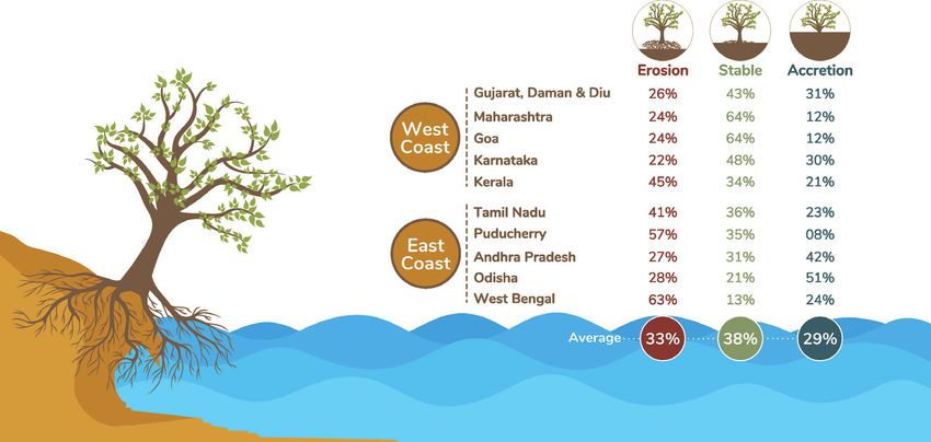
The State of India’s Coastline
A 26-year study of the Indian shoreline from 1990 to 2016 shows that a third of
the coast is seeing erosion, 38% is stable and the rest is accreting. West Bengal
is the worst affected with 63% of its coastline eroding.36
38 | The Face of Disasters 2019The Global Risks Report 2019 by the World Economic Forum shows that
this relative sea-level rise poses the highest risks for the Krishna (India),
Ganges-Brahmaputra (Bangladesh) and Brahmani (India) deltas. In
Bangladesh, a rise of 0.5 metres would result in a loss of about 11% of the
country’s land, permanently displacing approximately 15 million people.37
Fleeing the consequences: What happens
to climate-induced migrants?
1.35 million new What is the cost to a family who has to leave their home, washed away
displacements due to or in search of water? Over 246 million people were displaced by
disasters globally in the last 10 years. There were close to 1.35 million new
disasters in India in 2017
displacements due to disasters in India in 2017 alone.38
alone.
In recent times, the idea of climate refugees is emerging, in terms of
movement across countries. However apt this may seem as a concept,
those forced to move due to disasters or climate related issues do not
qualify as ‘refugees’ under international law. ‘Refugee’ status is accorded
only to those who face persecution if they return.
In fact, there is no clear policy that exists on climate-induced
displacement either nationally or internationally. This is partly because
loss and damage from climate induced events is rarely comprehensively
tracked, and the relationship to migration becomes difficult to quantify.
What is clear is that the number of people affected will only increase,
with internal climate migration intensifying over the next several
decades.39
The Face of Disasters 2019 | 39IN FOCUS
Satbhaya: A village in Odisha
swallowed by the sea
In 2007, the village of Satbhaya in Odisha showed a dangerous
Wetlands provide trend. Close to half of the village area (155 sq. km. of land)
livelihoods, are highly had been submerged in the sea. Only three kms of the bund
effective carbon sinks, constructed after the 1971 cyclone remained, eroded away by the
help recharge rapidly sea and wind. As a result, about 80% of the village was exposed
to the sea. In addition, the villagers had also constructed their
depleting groundwater
houses on parts of the bund which protected them from flood
and serve as a first line
waters but made them more vulnerable to cyclonic winds. Each
of defense to protect farmer used to have 5-7 acres of land. Those few located behind
communities. the bunds were protected but the rest had problems of sea water
intrusion and increasing soil salinity. With no sewage or drainage
system in the village, waterlogging and the risk of diseases such
as malaria were common.
The village had a school with classes up to 7th standard.
However, the school building was close to the shore and was
not protected by bunds. Hence during high tides or storms the
building would get partially submerged. As a result, sand had
accumulated around the school building. Satbhaya village also
did not have any medical facility. An auxiliary nurse midwife
would visit every 10-15 days and families would have to travel for
6 or 7 kms for any medical attention.
Satbhaya village has now become the first large-scale example
of a village relocation due to coastal erosion. The process has
taken decades, following sustained demands. Families have
been moved to a new location of Bagapatia which falls within
the Bhitarkanika Wildlife Sanctuary, a notified protected area with
restrictions on human activity. While relocated families now have
access to a hospital (and safer places to live), their livelihood
options are limited. Many travel back every day to the sea to
catch a few fish and try and sustain themselves.
About 35% of the world’s
wetlands have disappeared
since 1970.
40 | The Face of Disasters 2019You can also read


