GPS + Glonass Using the Best of Both Worlds - 10 I 12 TELIT WHITE PAPER
←
→
Page content transcription
If your browser does not render page correctly, please read the page content below
10 I 12 TELIT WHITE PAPER

 GPS + Glonass
Using the Best of
  Both Worlds

Jupiter SL869   Jupiter JN3

                                       Jupiter SE880
IMPROVE TIME-TO-FIRST-FIX
GET MORE ACCURATE POSITIONING
ENHANCE TIME IN NAVIGATION
COLLECT MOST RELIABLE PROBE-DATA
TABLE OF CONTENTS:
EXECUTIVE SUMMARY
1. GPS and GLONASS Technology -
Background Information
2. Restrictions of GPS-Only
3. Combining GPS & GLONASS
3.1. Test studies in Los Angeles,
London and Johannesburg
3.2. Central Findings
4. The Telit difference
4.1. Telit Jupiter SL869
4.2. Telit Jupiter JN3
4.3. Telit Jupiter SE880
5. About Telit10 I 12 TELIT WHITE PAPER
EXECUTIVE SUMMARY
At the end of 2011 the Russian government announced that GLONASS,
the Russian Global Navigation Satellite System (GNSS), is fully opera-
tional and has global coverage. Experts at Telit decided to test what
impact this has on satellite navigation and positioning. They conducted
tests in Los Angeles, London and Johannesburg to see the relevance of
GLONASS for the whole world. The results clearly showed that the
combination of GPS and GLONASS improves positioning tremendously.
Especially in urban canyons with huge skyscrapers the receiver had
the ability to track at least four satellites and thus calculate a fix –
which was impossible to guaranty using only GPS. Thanks to the SL869,
a newly released Global Navigation Satellite System (GNSS) module
from Telit that has access to both GLONASS and GPS, blind spots
were reduced and navigation performance was radically improved. This
white paper shows the test set-up and examines the results. For the
future further tests are planned.
31. GPS AND GLONASS TECHNOLOGY
Radio-based Global Navigation Satellite Systems the more accurate the fix will be. In theory this is pos-
(GNSS) are part of our daily life for navigation, survey- sible with GPS-only as there should always be at least
ing and mapping. Although there are several GNSS 5 satellites visible anywhere on the Earth’s surface. If
like the European Galileo or the Chinese Beidou, the there is an unobstructed view of the sky even 12 satel-
US GPS is the most popular one providing global cov- lites can be visible. But often there are buildings,
erage and used widely in navigation systems. Today trees, mountains or clouds blocking some of the GPS
there are 31 GPS satellites that are operational, plus signals, and the GPS receiver is unable to obtain a
3-4 decommissioned satellites that can be reactivated position fix.
if needed.
Since October 2011 the Russian GLONASS has been
fully operational with 24 satellites in orbit plus four in
reserve and one currently undergoing trials. This is
not only an alternative to GPS but, even more, the
completion of a combined GPS/GLONASS system
where there are in total 55 fully operational satellites
in outer space in different orbits (see picture 1). For
satellite navigation at least 4 satellites are needed to
determine a position solution: three to provide the
data for each space axis (x, y and z) and one to provide
the time sent. The more satellites that can be tracked,
410 I 12 TELIT WHITE PAPER
2. RESTRICTIONS OF GPS-ONLY
Especially in mega-cities with many skyscrapers, sat- further in urban environments. This makes it a real
ellite signals are often lost. For fleet management as challenge to isolate them from background noise.
well as for other types of tracking applications this To overcome the limitations of GPS-only navigation,
condition can be unacceptable. In addition there are the Telit engineers decided to launch a combined so-
further restrictions of GPS-only navigation: GPS satel- lution of GPS and GLONASS. The fact that there are
lites orbit the earth from a distance of 20,000 kilome- now in total 55 satellites operating in different orbits
ters. Their signals are barely -130 dBm once they covering the whole globe must have an impact on nav-
reach a terres-trial receiver, and are degraded even igation and should provide advantages.
Picture 1:
Orbits of different GNSS
Geostationary
20 hours
Earth Orbit
Orbital period
Compass
GALILEO 15 hours
MEO satellites
GPS
10 hours GLONASS
5 hours
Radius of Height above
orbit Iridium Hubble sea level
40 Mm 30 Mm 20 Mm 10 Mm 10 Mm 20 Mm 30 Mm
20000 10000 10000 20000
miles miles ISS miles miles
15000 mph 25000 km/h
20000 km/h
10000 mph
15000 km/h
Orbital speed
5
Orbital speed
15000 km/h
10000 mph
20000 km/h
15000 mph 25000 km/h
miles miles ISS miles miles
20000 10000 10000 200003. COMBINING GPS & GLONASS
3.1. Test studies in Los Angeles, London and
Johannesburg
In February 2012 the Telit GNSS engineers decided to to determine a position solution. With a GPS+GLONASS
run a field test comparing the navigation accuracy of receiver this didn’t happen – the receiver never lost
GPS only receivers and GPS+GLONASS receivers. The the signal. Furthermore there is a huge difference in
team did seven test tracks between 11:00 a.m. and the accuracy of ground track.
3:00 p.m. in Downtown Los Angeles. They tested
several standard GPS only units in comparison to the With GPS there were several meters tracked off-road,
Jupiter SL869, Telit’s new GNSS module which pro- means the track was not on the street but next to it.
cesses both GPS and GLONASS signals. The results With GPS+GLONASS the positioning was very accu-
were always very similar: Combining GPS and GLONASS rate and it didn’t happen at all.
provided much more accurate and better positioning
possibilities instead of GPS only – see picture 2.
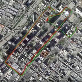
The picture shows a single test track. The red line rep-
resents GPS only. It shows that during the test track
there were several instances where GPS was not able
Tracked way in Los Angeles.
Picture 2:
Tracked way in Los Angeles. Green
shows the route which was driven with
GPS & GLONASS receiver, red the same
route with a standard GPS-only receiver.
610 I 12 TELIT WHITE PAPER
A similar study was conducted in London on March, The same test tracking was done with GPS+GLONASS.
20th 2012 monitoring the number of satellites used It showed that there are always more than 4 satellites
by a GPS-only receiver and by a GPS+GLONASS re- in track. A fix is virtually guaranteed (picture 4). In
ceiver. The findings were the same as in Los Ange- addition even up to 15 satellites were tracked in the
les: Because of signal blockages in London caused middle of London were it wasn’t possible to track
by five story buildings, the number of tracked GPS more than 8 satellites with GPS-only. That nearly
satellites dropped below four (picture 3). Thus the doubled the available satellites.
GPS-only receiver lost its fix point. This happened
three times, of which the time around 3:00 p.m. was The third test was conducted in Johannesburg, South
the most critical one. At that time the receiver had Africa to verify the availability and advantages of GPS
no track for app. 20 minutes. and GLONASS in the southern hemisphere. The re-
sults in South Africa were similar to the results in
London and Los Angeles: With approximately 18 satel-
lites used for the fix with GPS and GLONASS in
comparison to 6-8 satellites with GPS-only, not only
Tracked satellites. does the number of visible satellites double, time in
10 navigation improves and a fix is virtually guaranteed.
9
8
Number of Satellites
7
6
5 Tracked satellites.
4
20
3
18
2
16
1
Number of Satellites
14
0
12
00:00 03:00 06:00 09:00 12:00 15:00 18:00 21:00 24:00
10
8
6
4
2
0
00:00 03:00 06:00 09:00 12:00 15:00 18:00 21:00 24:00
Picture 3:
The picture shows the number of satellites
Picture 4:
that were in track in London March, 20. Dark The picture shows the number of satellites
green shows times where the number of that were in track in London March, 20 with GPS
satellites drops below 4. +GLONASS. The number never drops below 6.
73.2. Central Findings
Thanks to the addition of GLONASS, the number of constellations is thus a major step forward in navi-
tracked satellites never drops below six in the gation, providing the best satellite geometry to ob-
tested environments, and the problem of lost tain the most accurate position possible more often
satellite coverage, especially problematic in urban – not only in Russia but all over the world. Finally,
canyons with tall buildings, is dramatically re- this enables a more accurate positioning, a better
duced. Furthermore the test showed that also the “pinning” of a person, a car or an asset’s true location
accuracy of positioning is significant improved. In on a digital map.
addition the team noticed an improved time-to-fix
which is for example vital for Stolen-Vehicle-Recovery
where it is crucial to locate the vehicle no matter
where it is. Accessing the combined GPS/GLONASS GNSS Satellites Used
20
18
GPS Satellites Used 16
14
Number of Satellites
12
10 10
8
Number of Satellites
8 6
4
6 2
0
4 0 5 10 15 20 25 30 35 40 45 50 55 60
Minutes
2
0 Picture 6:
0 5 10 15 20 25 30 35 40 45 50 55 60
Minutes
Number of satellites used for the position
Picture 5: fix with GPS and GLONASS during the same
Number of satellites used for the position fix hour in Johannesburg, South Africa. The
with GPS-only receiver during one hour in visible satellites doubles, positioning is
Johannesburg, South Africa. significantly improved.
810 I 12 TELIT WHITE PAPER
4. THE TELIT DIFFERENCE
4.1. Jupiter SL869 GNSS modules Equipped with a powerful yet power saving processor,
the module provides all the GNSS information via NMEA
In Los Angeles the Telit team tested the Jupiter SL869, standard protocol on a serial interface. The Telit Jupiter
a new series of GNSS modules from Telit. These SL869 can efficiently retrieve the correct position in
tests clearly showed that the SL869 maximizes the harsh environments using multiple GNSS constella-
performance over GPS alone by utilizing both the GPS tions and SBAS as well as real-time ephemeris data.
satellites plus the GLONASS. The results are: Higher
percentage in navigation, faster acquisitions and more 4.2. Jupiter JN3 GNSS module
precise and accurate position.
Although the combination of
The Jupiter SL869 is a state-of-the-art 32-channel GPS and GLONASS provides huge advantages, there
global navigation module able to receive, track and are also price differences. So in cases where a very
navigate using the entire spectrum of GNSS systems accurate position is not needed, but cents make a dif-
available in the world: GPS, GLONASS and QZSS, ference to a competitor, a GPS-only module would be
furthermore it is Galileo and Beidou ready. sufficient. Therefore Telit provides the Jupiter JN3
The extreme low profile and small size of the LCC which is pin-to-pin compatible to the SL869. So cus-
package enables the design of ultra-compact applica- tomers need only one design for the two alternatives
tions. The solution cost and required space is signifi- and can migrate whenever needed to one or the other
cantly reduced. With its ultra-compact design and without any problems.
extended temperature range, the Jupiter SL869 is a
multi-constellation receiver that is ideal for low, The Jupiter JN3 is a state-of-the-art 48-channel GPS
medium and high-volume M2M combined applica- module with high sensitivity, extremely low power
tions and mobile/tracking data devices. The results consumption, and extended ephemeris predictions for
are: Higher percentage in navigation etc. fastest TTFF. Coupled with a Telit GSM/GPRS module,
the Jupiter JN3 represents the ideal wireless+GPS
solution in terms of total cost effectiveness and
Jupiter SL869 Jupiter JN3
GPS | GLONASS GPS
16 x 12.2 x 2.4 mm 16 x 12.2 x 2.4 mm
9time-to-market readiness. The extreme low profile
and small size of the LCC package enables the design
of ultra-compact applications. The solution cost and Original size
4.7 x 4.7 mm
required space is significantly reduced. With its ultra-
compact design and extended temperature range, the
Telit Jupiter JN3 is the perfect module for low, medi-
um and high-volume M2M combined applications and 4.3. Jupiter SE880 – the smallest GPS receiver in
mobile/tracking data devices. Thus Telit can always the market
provide the perfect module for every need.
Telit offers the smallest GPS receiver in the market,
the SE880, which is ideally suited for applications
in the commercial, industrial, and consumer seg-
ments including wearable and handheld devices.
DE910-DUAL
Also Telit’s DE910-DUAL features a GPS and The miniature 4.7x4.7mm LGA (Land Grid Array),
GLONASS receiver that improves time for navi- SiRFstarIV™-based receiver module employs lead-
gation and tracking performance in limited sky ing 3-D component embedding technology to achieve
environments as well as additional benefits de- best-in-class performance in all dimensions critical
scripted in this White Paper. The DE910-DUAL for regular or size-constrained GPS applications.
Because of this extreme sensitivity with -148dBm,
is a 3G CDMA 1x EV-DO Rev A module with built
the 48-channel receiver can reduce cold start Time-
in GNSS receiver that is part of the Telit’s xE910
to-First-Fix (TTFF) by more than 3 minutes. In addi-
Family. The family features a single, compact tion it allows class-unique achievements such as a
form factor that is interchangeable on any re- one-satellite acquisition of UTC (typically 4 are re-
gional cellular network and across technolo- quired) and fix acquisition with minimal sky-visibility
gies, delivering ubiquitous, cost-effective cov- – garages, urban canyons, etc. Even indoor fixes are
erage for m2m applications. possible in less than 200 seconds.
For more information about the
Telit xE910 family please visit Jupiter SE880
GPS
www.telit.com or check the
4.7 x 4.7 x 1.4 mm
QR-code.
DE910-DUAL
CDMA | 1xEV-DO Rev.A
10 28.2 x 28.2 x 2.4 mm10 I 12 TELIT WHITE PAPER
Telit’s Jupiter SE880 includes all components neces-
sary for a fully functioning receiver design requiring
only a 32 KHz external crystal for its time-base and
5. ABOUT TELIT
TCXO to complete the design, along with antenna,
power and data connections adequate to the integra-
tor’s needs. The SE880 receiver module was con- Telit Wireless Solutions is a brand of Telit Communica-
ceived to shorten Time-to-Market and to make the tions PLC (AIM: TCM), an enabler of machine-to-ma-
chipset-versus-module decision an easy one to chine (M2M) communications worldwide providing
make for device integrators. Integrators can attain a wireless module technology, M2M managed services
working SE880-based design in as little as a week and value added services, including connectivity. Exclu-
versus several months when starting from a chipset sively dedicated to M2M with more than 12 years of
reference design. experience in the market, the company constantly en-
hances its technology leadership with six R&D centers
In addition the Jupiter SE880 has a multi-filter system across the globe. Telit offers an extensive portfolio of
which includes not only the traditional SAW filters typi- the highest quality cellular, short-range RF, and GNSS
cal in GPS receiver designs but also a 2.4 GHz notch- modules, available in over 80 countries. By supplying
filter capable of nullifying the jamming effects of high- scalable products that are interchangeable across
energy radio devices such as Wi-Fi hot-spots, Bluetooth families, technologies and generations, Telit is able to
systems, and others, which greatly affect a GPS receiv- keepdevelopment costs low and protect customers’
er’s ability to resolve timid satellite signals in the hos- design investments. In addition, Telit is the only module
tile radio environment where they need to operate. provider in the market today to offer a value added
services bundle including connectivity dedicated to
Other distinguishing features of the Jupiter SE880 in- simplifying the deployment of M2M applications.
clude an extended operating temperature range
wherein noise-versus-gain performance is linearly Telit provides unmatched customer support and pre-
balanced throughout the range with class-leading mier design-in expertise through its 25 sales and sup-
sensitivity stability particularly at the extremes of -40 port offices, a global distributor network of wireless
and +85°C – critical for applications such as sports experts with more than 30 Telit-designated Competence
watches and OEM automotiv navigation systems. For Centers, and its online Telit Technical Support Forum.
more information about the Telit
SE880 please visit www.telit.com or Telit technology enables organizations to wirelessly
check the QR-code. collect, process and respond to real-time data creat-
ing new efficiencies and revenue opportunities as
well as societal and personal benefits. Further
information about Telit and its products can be found at
www.telit.com.
11Contact
EMEA Latin America
Telit Communications S.p.A. Telit Wireless Solutions Inc.
Via Stazione di Prosecco, 5/B Rua Cunha Gago, 700 – cj 81, Pinheiros
34010 Sgonico (Trieste), Italy São Paulo – SP, 05421001, Brazil
Phone: +39 040 4192 200 Phone: +55 11 3031 4051
Email: EMEA@telit.com Email: latinamerica@telit.com
North America APAC
Telit Wireless Solutions Inc. Telit Wireless Solutions Co. Ltd., APAC
3131 RDU Center Drive, Suite 135 12th floor, Shinyoung Securities Building
Morrisville, NC 27560, USA 34-12, Yeouido-dong, Yeongdeungpo-gu
Phone: +1 888 846 9773 Seoul, 150-884, Korea
Email: northamerica@telit.com Phone: +82 2 368 4600
Email: APAC@telit.com
www.telit.com/ebook www.telit.com/facebook
www.telit.com/techforum www.telit.com/twitterYou can also read