Greater Norwich Local Plan Infrastructure
Needs Report
←
→
Page content transcription
If your browser does not render page correctly, please read the page content below
Greater Norwich Local Plan Infrastructure Needs Report
Contents
Executive Summary .............................................................................................................. 1
1.      Introduction .................................................................................................................. 1
2.      National Planning Policy, Guidance and Legislation ...................................................... 1
3.      Relevant Local Infrastructure Plans and Strategies ....................................................... 2
4.      Growth in the Local Plan ............................................................................................... 4
5.      Transport ....................................................................................................................... 9
     5.1 Pedestrians and cycle .................................................................................................. 9
     5.2 Bus and rail ............................................................................................................... 10
     5.3 Road .......................................................................................................................... 11
6.      Utilities ........................................................................................................................ 13
     6.1 Water and Flooding................................................................................................... 13
     6.2 Power ........................................................................................................................ 14
     6.3 Digital ........................................................................................................................ 16
7.      Education .................................................................................................................... 17
     7.1 New Schools .............................................................................................................. 18
     7.2 Primary...................................................................................................................... 11
     7.3 Secondary ................................................................................................................. 12
8.      Health Care .................................................................................................................. 21
     Primary Care Requirements ............................................................................................ 21
     Hospital ........................................................................................................................... 25
     Mental Health ................................................................................................................. 25
     Community Services........................................................................................................ 27
9.      Police ........................................................................................................................... 29
10. Fire and Rescue ............................................................................................................. 30
11. Community, Sport and Leisure Facilities ....................................................................... 31
     11.1 Libraries .................................................................................................................. 31
     11.2 Community centres ................................................................................................. 32
     11.3 Sports and leisure.................................................................................................... 32
12. Open Space and Green Infrastructure .......................................................................... 34
13. Waste Management ..................................................................................................... 35
14. Summary of Infrastructure Requirements .................................................................... 37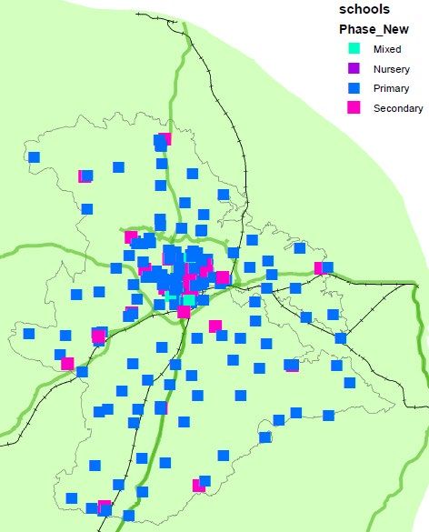
Executive Summary

1. Introduction
Purpose of the document
The vision for Greater Norwich to 2036 is ‘to grow vibrant, healthy communities supported
by a strong economy and the delivery of homes, jobs, infrastructure and an enhanced
environment.’
The provision of new and improved infrastructure is essential to ensure the growth planned
in the District is sustainable. Infrastructure includes a wide range of facilities and services
including schools, medical facilities, community facilities, open space, roads, railways, cycle
paths and flood defences.

This report is a review of the infrastructure requirements within the Greater Norwich Area.
Greater Norwich is a partnership between Broadland District Council, Norwich City Council
and South Norfolk Council.

2. National Planning Policy, Guidance and Legislation
2.1 National Planning Policy Framework
The National Planning Policy Framework states that local plans should make sufficient
provision for infrastructure requirements including transport, waste management, water
supply, flood risk, and the provision energy in addition to the provision of community
facilities such as libraries, schools and other cultural infrastructure (paragraph 20).

It goes on to state that to achieve sustainable development the planning system should
identify and coordinate the provision of infrastructure. Effective and on-going joint working
should help to determine where additional infrastructure is necessary, and whether
development needs that cannot be met wholly within a particular plan area could be met
elsewhere.

2.2 Community Infrastructure Levy
The Community Infrastructure Levy (CIL) was introduced in 2010 through the Community
Infrastructure Levy Regulations 2010. The Community Infrastructure Levy (CIL) allows local
authorities to charge a tariff, at a locally set rate, on many types of new development.
The Greater Norwich authorities adopted CIL charging between 2013 and 2014 with a
variation of CIL charging rates across each local planning authority area 1.

1
    Greater Norwich CIL Charging Schedule - http://www.greaternorwichgrowth.org.uk/planning/cil/
3. Relevant Local Infrastructure Plans and Strategies The following infrastructure plans and strategies have been used to support the creation of this report. 3.1 New Anglia Integrated Transport Strategy The Strategy looks ahead to the 2040s but focuses on the actions we need to take over the next three to five years to help secure the foundations for long-term success. It is a dynamic and living blueprint to guide the work and investment of many interested partners. 3.2 Highways England A47 Corridor Improvement Plan In 2014 the UK Government established the Road Investment Strategy. As part of this the East of England was identified as an area in need of investment. 17 major road schemes were identified as requiring investment including 6 schemes along the A47. It is recognised that the A47 has several congestion hotspots around Norwich, Peterborough and Great Yarmouth. These result in delays and concerns regarding safety for all road users. There are also developments resulting in significant growth predicted along the A47 through Norfolk and these are the areas which the Corridor improvement plan will help to support for the local communities affected. 3.3 Norfolk Strategic Infrastructure Delivery Plan The strategic infrastructure delivery plan pulls together information on the key infrastructure needed to deliver economic growth in Norfolk. It is a working document that will be reviewed on a regular basis as information becomes available and projects progress through to delivery. The Plan will help Norfolk County Council and partners to co-ordinate implementation, prioritise activity and respond to any funding opportunities. 3.4 Norfolk Strategic Planning Framework All planning authorities in Norfolk have agreed to prepare a combined Strategic Framework planning document. This provides the overarching framework for planning issues across the county with an emphasis on strategic land use issues with cross boundary implications. The document forms part of the process to demonstrate compliance with the Duty to Cooperate (Localism Act 2011). It relates to the period 2012 to 2036 and will inform the preparation of Local Plans produced by individual planning authorities during this period. The framework includes strategic guidance in relation to housing, economic growth, infrastructure provision and environmental considerations, including in future an agreed approach to Habitats Regulation Assessment. 3.5 Local Transport Plan Norfolk’s third Local Transport Plan 2011-26 has been adopted. This describes the county’s strategy and policy framework for delivery up to 2026. It will be used as a guide for transport investment and considered by other agencies when determining planning or delivery decisions. Six priorities included: Maintaining and managing the highway network, delivering sustainable growth, enhancing strategic connections, reducing emissions, improving road safety and Improving accessibility.
3.6 Norfolk Rail Prospectus
To be effective in influencing decisions, the county council needs to be clear about what its
requirements are. The purpose of this Rail Prospectus is to set out Norfolk County Councils
requirements. We will use it in our dealings with government, train companies, Network Rail
and other stakeholders to get the best for the people of Norfolk. The prospectus is being
updated in 2019 and will include longer term requirements going to 2029 and beyond.
3.7 Transport for Norwich
Transport for Norwich is a programme of work to improve accessibility by all forms of
transport in and around the city. The aim is to encourage the use of more sustainable forms
of transport, such as public transport, cycling and walking, while also improving the capacity
of the road network. It’s also designed to stabilise traffic levels and as a result improve air
quality around the city. With plans for 30,000 new homes and jobs in Greater Norwich over
the next decade, an important part of this new infrastructure is to prepare the area for this
growth in population by connecting new and existing communities to centres of
employment.
3.8 Greater Norwich Infrastructure Plan and 5-year Investment Plan
The GNIP helps coordinate and manage the delivery of strategic infrastructure to support
growth, a high quality of life and an enhanced natural environment. It informs prioritisation
of investment and delivery. It is not an exhaustive list and is a living document, updated
annually to reflect the latest information.

The projects then identified in the 5-year investment plan are those currently considered to
be a priority for delivery to assist in achieving the economic growth targets as set out in the
Joint Core Strategy and the Greater Norwich City Deal.
3.9 Market Town Network Improvement Strategies
Many of Norfolk’s market towns and larger villages have a considerable amount of planned
housing and employment growth identified through the relevant Local Plans. There are
currently 4 strategies being produced in the Greater Norwich area for: Diss, Aylsham,
Wroxham/Hoveton and Wymondham. These will identify the most effective transport
improvements to support future planned growth and help address transport issues such as
congestion, enhancements to safety and access to public transport.
4. Growth in the Local Plan
4.1 Housing
The Government recently consulted on a revised methodology for deriving local housing
need and this gives an annualised need of 2,066 homes per annum for the Greater Norwich
area. Using the Government’s consultation version of the standard methodology for
calculating housing need, and re-basing the figures to 2018, suggests that the housing need
to 2036 is 37,200 homes.
To provide for general uncertainty (such as delayed or slow delivery, and fallout of
permissions), a delivery buffer of 10% was proposed for last year’s Growth Options
consultation. Applying a 10% delivery buffer would give a plan requirement of 40,900
homes. With the existing commitment of 34,100 homes at April 2018 the new sites will need
to be identified for at least 6,800 homes.
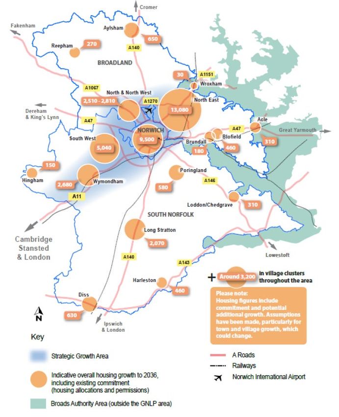
Figures 1 and 2 and Table 1 set out past completion rates and projected completions, the
proposed strategy for the distribution of new growth and the growth locations.
Figure 1. Greater Norwich housing completions and trajectory

                       4,500

                       4,000

                       3,500
 Number of Dwellings

                       3,000

                       2,500

                       2,000

                       1,500

                       1,000

                        500

                          0
                                                                                                       2009/10
                                                                                                                 2010/11
                                                                                                                           2011/12
                                                                                                                                     2012/13
                                                                                                                                               2013/14
                                                                                                                                                         2014/15
                                                                                                                                                                   2015/16
                                                                                                                                                                             2016/17
                                                                                                                                                                                       2017/18
                                                                                                                                                                                                 2018/19
                                                                                                                                                                                                           2019/20
                                                                                                                                                                                                                     2020/21
                                                                                                                                                                                                                               2021/22
                                                                                                                                                                                                                                         2022/23
                                                                                                                                                                                                                                                   2023/24
                                                                                                                                                                                                                                                             2024/25
                                                                                                                                                                                                                                                                       2025/26
                               2001/2
                                        2002/3
                                                 2003/4
                                                          2004/5
                                                                   2005/6
                                                                            2006/7
                                                                                     2007/8
                                                                                              2008/9

                                                                                Completions 2001-2017                                                                                               Projected Completions 2018-
                                                                                                                                                                                                               2026

                                           Average Completions in Local Plan Period                                                                                   Annual Housing Need Requirement
Table 1 The proposed strategy for the distribution of growth
Area Indicative scale of Location Comments Commitment
new allocations 2018
Norwich City 2,500 Majority in East Norwich Increased from the Reg 18 base of 1,500 to take account of 7,000
Area emerging brownfield opportunities e.g. Archant and
Britvic/Unilever
North East 200 Thorpe St Andrew Some brownfield opportunities 378
Sprowston 18
Rackheath Potential smaller sites and uplift in existing allocations. But 12,252
need to consider how much could be delivered in plan
period or post-2036
North/North 500-800 Drayton 100 additional already permitted and 304
West Possible uplift on current allocation
Hellesdon A range of various sites across the four parishes 1336
Horsford 365
Horsham and Newton St 65
Faith
Taverham 15
South West 600 Costessey Possible large site not included here 514
Easton Possible uplift within existing allocation 901
Cringleford Scope for uplift in land identified in NP 1415
Hethersett c100 uplift in current allocation 1147
Little Melton Possible small-scale sites 38
Total 3,800-4,100
Towns and Key 1,200-1,500+
Service Centres
Towns 900-1,000+ Aylsham Each of the towns have a range of potential sites 216
Diss Significant capacity in existing allocation, but need to 333
Harleston consider scale of additional delivery before 2036 173Long Stratton 1851
Wymondham Small allocation to take account of existing commitments? 2548
(Possible large site not included here)
KSCs 400-600 Acle 189
Blofield Large existing commitment suggests very little additional 361
Brundall 150 recent permission 175
Hethersett (under South West above) -
Hingham 0
Loddon and Chedgrave 186
Poringland/Framingham Large existing commitment suggests very little additional 374
Earl
Reepham 146
Wroxham Constraints suggest more limited potential 4
Village Clusters 2,000 Specific locations will be the subject of further analysis 1,200
Total 7,000-7,600
Contingency
Large-scale sites for testing as possible Taverham c1,500 dwellings extension to the north of Thorpe Marriot
alternatives or contingency sites
Costessey (largely in c1,000 dwellings on site(s) south of Lodge Farm, west of
Bawburgh parish) Bowthorpe
Sprowston c1,200 dwelling site adjacent to current White Woman
Lane development in NEGT could be allocated, but assume
no net impact on NEGT delivery pre-2036 given current
commitment in the area
Wymondham c1,000 dwellings at North East Wymondham
And/or similar scale to the south of the townFigure 2 Greater Norwich Indicative Housing Growth Locations
4.2 Economic Growth
Evidence suggests that the Greater Norwich economy has grown by around 20,000 jobs
since 2008 (the Joint Core Strategy base date) and 30,000 since 2011 (the low point after
the recession).
Greater Norwich is worth over £10bn (Gross GVA 2013 prices) to the UK’s economy with key
sectors which include; life sciences and biotech; advanced manufacturing and engineering;
agriculture, argitech and food & drink; ICT, technology creative and digital; visitor, economy,
tourism and culture; and financial, services and insurance.

Since 2011 the Greater Norwich Area has supported an average job growth per year of
3,300 2 jobs per year. The population projections for the Greater Norwich Area show an
increasing population, to meet the requirement of an increasing population there will be a
minimum requirement for an additional 22,000 new jobs. Local evidence has shown that the
total amount of allocated and permitted employment land is more than sufficient to provide
for expected and promoted growth. There may be a local need for some new small-scale
allocations to provide for jobs growth in towns and villages, providing local job
opportunities and supporting a vibrant rural economy.

2
    EELGA Jobs Growth Data 2011-2018
5. Transport
Future housing growth will increase the road users which will impact on the transport
network in Greater Norwich.
5.1 Pedestrians and cycle
Overview
The Walking and Cycling Strategy for Norfolk published in 2016 sets out the Council’s vision
for cycling and walking including the aims that by 2025:
• More people walk and cycle to get to places of work and education;
• Walking and cycling are normal activities for most people;
• Routes are direct, convenient and pleasant.
The strategy sets out the aim to increase the mode share of cycling and walking to 10% of all
journeys by 2025 and 25% by 2025. In Norwich cycling makes up 8.8% of commuter
journeys, with walking making up 24.8%.
Norwich’s Cycle Network consists of five radial and two orbital pedalways and has been
developed since the spring of 2012 (called the Pedalways). The walking network is less well
defined however, but there are a wide range of infrastructure and routes including a core
area within the inner ring of the city centre that benefits from large areas of pedestrianised
zones.
The Pedalways network extends through the urban area, intersecting in the city centre at St
Andrews Plain and connect hubs such as public transport interchanges, employment
centres, the universities, major growth locations and the city centre, while the gaps are
filled in by neighbourhood routes that connect to schools and local shops.
To date the network has benefited from funding allocated to the City Council as part of the
DfT Cycling City Ambition Grant (CCAG). This funding has seen £14.1m invested in the
network since 2013 across two phases. The first phase focused on the pink pedalway
between Norfolk & Norwich University Hospital and UEA to Heartsease and Broadland and
the second phase on two pedalways, the yellow pedalway between Norwich International
Airport and Lakenham and the blue pedalway from Sprowston to Wymondham. As a result,
a 65.6 % increase in cycling has been seen at sites that received the first round of funding
focused on the Pink Pedalway and a 51.7% increase has been seen at sites that received the
second phase of funding focused on the Blue and Yellow Pedalways.
Needs
To look at the needs of the pedestrian and cycling network to support the future planned
growth in the area, a Local Cycling and Walking Infrastructure plan (LCWIP) is currently
being developed. LCWIPs provide a strategic approach to identifying cycling and walking
improvements required at the local level and form a vital part of the Government’s strategy
to increase the number of trips made on foot or by cycle by developing and expanding the
current cycling and walking zones and network. The outputs of this work include:• a network plan for walking and cycling which identifies preferred routes and core
zones for further development
• a prioritised programme of infrastructure improvements for future investment
• a report setting out the underlying analysis carried out, which provides a narrative
which supports the identified improvements and network
Costs and Funding
The total costs for the improvements suggested in the LCWIP are currently unknown as
many of the projects are not at an advanced stage of planning. However, as these projects
will be completed in partnership with Norfolk County Council as the local highways
authority, the outputs of the LCWIP should allow for the identification of cycling and walking
infrastructure improvements for future investment in the short, medium and long term. As
many of the projects set out in the LCWIP Cycle Strategy will help reduce the impact of new
developments planned in the Local Plan, they could therefore benefit from Community
Infrastructure Levy funding.
5.2 Rail
Overview
Rail provision in the Greater Norwich consists of the following routes:
• Norwich to London Liverpool Street
• Norwich to Cambridge
• Norwich to Sheringham
• Norwich to Great Yarmouth and Lowestoft.
The following stations are in the Greater Norwich area Norwich, Salhouse, Brundall Gardens,
Brundall, Buckenham, Cantles, Reedham, Haddiscoe, Lingwood, Acle, Diss, Wymondham
and Spooner Row.
Needs
The Norfolk Rail Prospectus 2013 identifies several improvements to infrastructure and
services on the rail routes. This is currently being reviewed.
Costs and Funding
Funding for rail improvements will come from Network Rail and the current franchise
operator within the Control Periods and franchise agreements. There has been a significant
investment in the rail network and the introduction of new trains along with the delivery of
Norwich in 90 services, which will commence in May 2019.5.3 Road Overview The A11 and A47 are both part of the strategic road network managed by Highways England. The A11 runs from Norwich to Cambridge and A47, Lowestoft to the A1 at Peterborough. The A11 is fully dualled and the A47 is a mixture of single and dual carriageway. Highways England are committed to dualling the A47 Easton to Tuddenham and Blofield to North Burlingham and junction improvements to the Thickthorn roundabout and in Great Yarmouth. The Broadland Northway was delivered to the north of Norwich connecting the A47 east of Postwick to the A1067 Fakenham Road north of Taverham. The County Council is working to complete this route by constructing the Norwich Western Link to the A47 west of Norwich. There is also ongoing work to complete the Broadland Growth Triangle Link Road. The Broadland Northway, A140 and A146 have been recently identified as key roads and are now part of the Major Road Network. The A140 Long Stratton Bypass is a County priority and work is progressing on the scheme. A network of A roads connects the market towns to each other. Elsewhere, the road network is mainly made up of small quiet country lanes. The Norfolk Local Transport Plan (2011- 2026) covers the strategy for transport in Norfolk. This is currently being reviewed. Funding for roads improvements can come from Highways England Roads Investment Strategies, Major Road Network, Local Majors, transforming cities fund, UK Shared Prosperity Fund, County Council and developers. Needs A major improvement at Thickthorn junction to address existing and future congestion problems has been included in the Highways England A47 corridor improvement programme. Committed developments in Cringleford and Hethersett are expected to increase traffic demand at Thickthorn junction and the A11/Round House Way junction significantly by 2026. The scheme will help relieve congestion at Thickthorn junction by providing 2 new free flowing link roads that will connect the A47 with the A11. The new roads will re-route traffic away from the junction and flow under 3 new underpasses. The dualling the A47 between Blofield and North Burlingham has been included in the Highways England A47 corridor improvement programme. Highways England have identified that the Blofield to North Burlingham stretch of the A47 showed that this section of the A47 was currently operating at 108% (of 2011 capacity). These issues are only likely to be increased by further planned growth and Highways England have proposed a new dual carriageway with two junctions. The road between North Tuddenham and Easton is not adequate to cope with the high volume of traffic. There is a clear and demonstrable need to increase capacity along the route. Highways England have included improvements in the A47 corridor programme providing a new dual carriageway to the south and north of the existing road and two junctions.
Based on analysis carried out by Highways England, further trunk road junction
improvements in addition to those committed above will be required for future growth. The
A47 Longwater Interchange and in particular the eastbound off slip may require an
improvement scheme to support development. There are a range of options for
improvements at Longwater with funding opportunities through Government and
Transforming Cities.

Highways England have also identified that the following junctions will require further
investigation:

   •   A47/A140 Ipswich Road
   •   A47/A146 Loddon Road
   •   Spinks Lane Wymondham
   •   New Road Acle
Costs and Funding
The major Thickthorn junction scheme is estimated to cost £25-50m with a construction
period start date of 2021-22.
The Blofield to North Burlingham improvements are estimated to cost £50-£100m with a
construction period start date of 2021-22.
The North Tuddenham to Easton improvements are estimated to cost £100-£250m with a
construction period start date of 2021-22.
An outline business case is being prepared for the A140 Long Stratton Bypass and is due to
be completed by December 2019. This will be carried out by an expert consultant to develop
the business case for the scheme to support the Major Road Network Funding
announcement in summer 2019. A bid for £31m has been submitted to DfT for Major Road
Network funding. If successful, this would allow construction to start in late 2020 with
completion in mid-2022.
The Norwich Western Link is required to connect the Broadland Northway at Taverham to
the A47 west of Norwich. Scheme development work has commenced with consultation
carried out on four route options. The preferred route announcement will be made in Spring
2019. The next phase of scheme development is estimated to cost £10m covering:

   •   Preliminary design;
   •   Completion and submission of outline Business Case;
   •   Statutory procedures and powers;
   •   Procurement and detailed design for construction preparation.
This work has been indicated to need three years to complete with an estimated start date
for construction of 2023. The construction phase has an indicative cost of £160m.
6. Utilities
6.1 Water and Flooding
Overview
Anglian Water’s business plan for the next Asset Management Plan period (2020 to 2025)
was submitted in August 2018 to the regulator Ofwat and is expected to be approved in
December 2019.
Norfolk County Council as the Lead Local Flood Authority (LLFA) are unable to comment on
the emerging Local Plan at this stage due to the lack of specific site allocations. As per the
Strategic Flood Risk Assessment, development should avoid significant areas of flooding in
the first instance and any mitigation e.g. for brownfield development, should come forward
as part of specific developments.
The Greater Norwich local planning authorities, Broadland District Council, Norwich City
Council and South Norfolk District Council, working with Norfolk County Council (the
Authorities) are looking to appoint consultants to undertake a Water Cycle Study (WCS)
which will support the joint plan-making process for the Greater Norwich Local Plan (GNLP).

The WCS should demonstrate that adequate foul drainage can be provided in a timely
manner ahead of occupation of new properties. Any necessary upgrades to existing
infrastructure should be completed prior to occupation.

Needs
Documents that plan proposed growth in the emerging Greater Norwich Local Plan include:

       •   Our Plan 2020 to 2025 (Anglian Water’s business plan)
       •   Revised Draft Water Resource Management Plan
       •   Water Recycling Long Term Plan
       •   Greater Norwich Water Cycle Study
Anglian Water does not anticipate a need for further investment by Anglian Water in
addition to that outlined in the Revised Draft Water Resource Management Plan.
Costs and Funding
Anglian Water as a water and sewerage company seeks fair contributions through charges
directly from developers under the provisions of the Water Industry Act 1991 to supply water
and/or drain a site effectively. As such Anglian Water would not, in most cases, make use of
planning obligations or standard charges under Planning Legislation for this purpose.
Charging mechanisms have been simplified, with most companies now introducing a standard
charge for all new dwellings which will be used to fund water supply and foul sewerage
network improvements.
Therefore, Anglian Water expect developers to fund connections and improvements to both
the water supply and foul sewerage networks by paying developer charges directly to the
company.
6.2 Power
Overview
The Greater Norwich Energy Infrastructure Study (March 2019) concludes that:
Growth across Greater Norwich imposes a significant challenge to some of the existing
energy infrastructure, without major upgrades to existing infrastructure at significant cost
the planned levels of development will not be possible in some areas. Particular capacity
concerns are highlighted at substations at Sprowston, Peachman Way (Broadland Business
Park), Earlham and Cringleford, serving a significant proportion of the growth planned for
through this plan.
The study states that regulatory barriers to the network operators investing in new energy
infrastructure can cause delays to providing increased energy capacity. The study therefore
makes a range of planning policy recommendations for the Greater Norwich Local Plan to
minimise energy demand and to reduce the carbon intensity of energy supplies,
encouraging the use of local and sustainable energy sources, including linking to local
energy networks where possible.
However, there are some locations which are currently most suitable for additional
development:
• Southeast and Southern Norwich - particularly where load has been freed up by
reductions in industrial usage.
• Areas to the east of South Norfolk district, supplied by Ilketshall Grid
Needs
A 33kV cable from Boundary Park Primary to Earlham Grid 33kV reinforcement and
Bramford-Norwich - 132kV reconfiguration being delivered in 2018/19.
Substation (132/33kV) Affected development sites
Sprowston Primary Beeston Park
Home Farm Sprowston
Land off Salhouse Road
Land south of Green Lane East
Land south of Green Lane West
Land south of Salhouse Road
Rackheath
White House Farm
Peachman Way Primary Broadland Gate
Brook Farm
Land east of Broadland Business Park
Land north of Broadland Business Park
Earlham Grid Local A/B Costessey
GN Food enterprise zone
Longwater / Easton
Norwich Research Park
Three ScoreCringleford Primary Cringleford
Hethersett
Costs and Funding
The traditional solution to grid constraints is to upgrade the local network connection at the
substation and in the local infrastructure. However, the capital costs to do this would be
between £2.5 million and £10 million, depending on the scale of the development. It is also
likely to take several years before the work can be undertaken.
There are ways to avoid or reduce the costs of improved network connection. Each site will
be different, dependent on what activity will be undertaken on the site and the local
vicinity. However, the following alternative approaches should be considered for all sites
affected by grid constraints:
• Semi-islanded approaches utilising on-site generation and smart energy
management solutions can enable development in constrained areas. Semi-islanded
development sites including high levels of on-site, renewable or low carbon
generation and batteries can be designed such that local benefits can be maximised
while also having a positive effect on local electricity networks.
• Work with the DNO to offer demand side response services, where on-site
generation could be turned up or load reduced in response to network signals, can
help balance supply and demand more locally and assist system operators to deal
with local constraint issues, so at times of network stress.
• Investment in infrastructure on these sites should be delivered through an Energy
Services Company model, which can then provide a steady revenue stream for those
involved.6.3 Digital Overview Better Broadband for Norfolk is using public subsidy to implement broadband infrastructure capable of providing access to Superfast broadband (24Mbps+) in areas which are not economically viable for broadband infrastructure providers. However, to apply public subsidy, state aid requires that the premises which qualify for subsidy are identified prior to letting a contract for the provision of broadband infrastructure. This means developments created after a Better Broadband for Norfolk contract is let, cannot be covered. The key message on fixed line broadband is therefore that developers must ensure this infrastructure is provided for new developments. As long as developers register new sites with Openreach, it will provide Fibre to the Premises infrastructure. Currently this is for developments of 30 units or more, although this figure is expected to reduce significantly in the near future. It is very important that sites are registered as early as possible, ideally before works begin: http://www.ournetwork.openreach.co.uk/property-development.aspx Developments which are close to Virgin Media’s existing infrastructure, may be able to link to existing infrastructure. The site is: http://www.virginmedia.com/lightning/network-expansion/property-developers Developers are of course free to select other broadband infrastructure providers if they wish to.
7. Education
Across Greater Norwich there are currently:
Norwich: 34 Primary Phase Schools and 8 Secondary Phase Schools
South Norfolk: 64 Primary Phase Schools and 9 Secondary Phase Schools
Broadland: 51 Primary Phase Schools and 7 Secondary Phase Schools

There is a mix of Community maintained, church and Academies with 47% of schools now
an Academy (at 1st May 2019). Of these schools, 15% in Broadland, 35% in Norwich and
42% in South Norfolk are full based on their last 2-year intake at reception and future
expected intake.

Figure 3. Location of schools in Greater Norwich area
7.1 New Schools
As at 1st May 2019, Norfolk County Council have the following schools either in the process
of being built or plans are in place for building over the next 2-3 years:

   •   Hethersett Primary School – a 420 place primary school situated within the new
       housing development in Hethersett. Expected opening September 2020.
   •   Cringleford new primary School – 420 place primary school situated within the new
       development of 1200+ new homes in Cringleford. Site has been identified and plans
       for the new school in process. Opening September 2022-23.
   •   Wymondham College prep school – a new 420 place Free School situated on the
       Wymondham College campus. Plan to open September 2020.
   •   Blofield – relocation and expansion of existing primary school – earliest opening date
       September 2022.
   •   White House Farm, Sprowston – new 420 place school currently under construction
       opening September 2019.
   •   Trowse – a new 210 place primary school within the Norfolk Homes development in
       Trowse. The existing school will move to this new building and expand from 105 to
       210 places from September 2020.
Other new schools are planned across the Greater Norwich area once housing and pupil
numbers suggest that existing schools in the area are no longer able to accommodate local
children. These are:

   •   Wymondham Silfield – 420 place primary school.
   •   Poringland – new school in response to considerable housing in the area – site
       search investigation being commissioned.
   •   Salhouse Road, Sprowston – site safeguarded for new 420 place school within new
       housing development.
   •   Hellesdon – new 420 place primary school within new development on former golf
       Club grounds.
   •   Beeston Park, North Norwich – sites for 2 x 420 place schools within proposed new
       housing development.
   •   Beeston Park – new secondary school in response to proposed housing.
   •   Rackheath – 2 x 420 new primary phase schools.
   •   Land north and south of Smee Lane, Norwich – planned new 420 place primary
       school in response to growth.
   •   Long Stratton – new 420 place primary school building in response to strategic
       growth in the village.

7.2 Primary
Across the 3 districts there are a total of 149 primary phase schools of which 126 admit a
reception intake (the remainder are Junior Schools). Of these schools, 40 have only 1 or 2
spare places at reception over the past 2 years. The challenge for Norfolk County Council is
to ensure that where new schools are planned in areas of growth, they are open at the
appropriate time, so all children have access to a school place locally. Several variables can impact on these plans such as securing a new school site and building a new school in a timely way to ensure sufficient school places but also to ensure enough children live in an area, so the new school will be viable. For September 2019 intake, the need for school places has been particularly challenging in pockets of growth mainly due to some new housing developments producing far more primary age children than originally anticipated. 7.3 Secondary 7 secondary schools provide places for Broadland District. 4 of these schools are larger and have over 1000 children on roll plus a 6th form, Reepham is a smaller school but does have a 6th form and both Aylsham and Acle do not provide 6th form places. Children who live in both Aylsham and Acle will need to access their further education either in Norwich or other schools who provide this. 6 of these schools are showing pressure for places apart from Acle. Some pressure is the result of parental preference rather than local children and NCC’s policy is to provide new places for local children when needed and not necessarily for preference patterns. An area with 8 secondary phase schools including the UTC (University Technical College). Norwich City has a Roman Catholic school in Notre Dame and a Free School with Jane Austen. The remaining 5 schools are known to place planning as North and South Norwich with CNS, City Academy and Hewett Academy in the south and Open, and Sewell Park Academy in the north. Both areas have one school that tends to attract children as much as the others and have considerable spare places. We expect these places to fill over time as larger cohorts move through the primary system into secondary. South Norfolk has 9 secondary schools in total with 3 larger schools – Wymondham, Hethersett and Ormiston Victory in Costessey capable of a capacity of over 1000 children. Hobart in Loddon and Long Stratton High often struggle with lower numbers of children. 7.4 Pupil Place Planning These 3 areas of Norfolk (Broadland, Norwich and South Norfolk) tend to attract families with children in larger densities compared with other areas in the County. Norfolk County Council operated their pupil forecasting model using a multiplier of 28.1 primary age children per 100 new homes. This figure is calculated using evidence of completed new housing developments across the whole county, but we are aware that this number can fluctuate across Districts, type and size of development and areas where there are popular schools both at primary and secondary phases. It is important that local variations are considered when planning school places particularly where a new school or expansion of an existing school is planned.
7.5 Costs and Funding
The costs to build a new primary phase school can vary depending on the layout of the site,
whether it has a nursery or not, ground conditions, availability of services.
In general, the cost to build a new 2 form entry (420 place) school is in the region of £8M.
As a rule, if a new development is likely to generate enough children to fill a new school NCC
would ask for the full cost of building that school. A pro rata contribution of the full cost
would be requested if numbers of children are calculated to be less than 420.
If an expansion of a new school is deemed more appropriate the cost of a per pupil place
would be claimed currently calculated at £14,022 or £3,940 per dwelling.
Being a CIL area, only land can be secured through a S106 agreement and the build cost of
the new school will be claimed through CIL.
8. Health Care
8.1 Overview
The consequences of the demographic and economic changes that are expected over the
next 20 years cannot be predicted with certainty but forward planning for healthcare
services is a high priority. The Greater Norwich area has its own Health Infrastructure
Delivery Plan, which could lead into future land-use allocations in the Greater Norwich Local
Plan. Examples may include allocating land for healthcare uses, securing land by planning
obligations from developers, or negotiating contributions to expand existing buildings and
facilities.
There are 6 partners in the Greater Norwich area, which cooperate through the STP. These
are:

   •   NHS Norwich Clinical Commissioning Group
   •   NHS North Norfolk Clinical Commissioning Group
   •   NHS South Norfolk Clinical Commissioning Group
   •   Norfolk and Norwich University Hospital NHS Foundation Trust
   •   Norfolk Community Health and Care NHS Trust
   •   Norfolk and Suffolk NHS Foundation Trust
In addition to these, the following three trusts have limited services within the area, but the
core of their services fall under different STPs:

   •   Cambridge Community Service NHS Trust (a small number of sites)
   •   Cambridgeshire and Peterborough NHS Foundation Trust (a single site)
   •   Hertfordshire Partnership University NHS Foundation Trust (a single site)
A full estate strategy is expected to be developed by the Autumn of 2019, which will impact
on the infrastructure requirements included in this section. Therefore, only currently
identified issues are included below and this section will need updating at the annual
refresh in 2020, once the trust’s strategy is complete.
8.2 Needs
Primary Care Requirements
Primary care is the first point of contact with the health system for patients and provides
the principal point of contact for continuing care for patients, with referrals to specialists
when necessary. All general practice (GP) surgeries are primary care, along with community
pharmacists and optometrists. There are 68 GP Surgeries spread across Greater Norwich
with 43 of these being main surgeries and 25 branch surgeries. There are over 462,000
patients registered with these surgeries. It is likely that upon the contractual formation of
Primary Care Network’s that there will be 8 covering the Greater Norwich area, with one
other impacted by the Greater Norwich Local Plan due to practice boundaries.
Table 2 below shows the existing capacity for GP practices in the Greater Norwich area:
Settlement                         Surgery name                            List size    Existing NIA   Capacity surplus /
                                                                           (weighted)   (sqm)          deficit (sqm) *
Norwich Urban Area                 St Stephens Gate Medical Practice       13,123       1,522          -622
Gurney - Norwich City Centre       Castle Partnership (Gurney, Mile End    16,798       930            221
Mile End and Tuckswood – Norwich   and Tuckswood Surgeries)
Urban Area
Norwich Urban Area                 The Magdalen Medical Practice           13,149       581            320
Norwich Urban Area                 Old Catton Medical Practice             6,374        435            2
Norwich Urban Area                 Trinity and Bowthorpe                   9,915        886            -206
Norwich Urban Area                 Hellesdon Medical Practice              10,182       522            176
Norwich Urban Area                 Roundwell Medical Centre                12,257       1,140          -299
Norwich Urban Area                 The Taverham Partnership                7,427        429            80
Norwich Urban Area                 Lakenham Surgery                        8,597        647            -58
Norwich Urban Area                 Wensum Valley Medical Practice (West    11,814       747            63
                                   Earlham, Bates Green and Adelaide
                                   Street surgeries)
Norwich City Centre                Oak Street Medical Practice             8,438        531            48
Norwich Urban Area                 Thorpewood Medical Group                13,091       460            438
                                   (Thorpewood and Dussindale Surgeries)
Norwich Urban Area                 Bacon Road Medical Centre               4,900        293            43
Norwich Urban Area                 Newmarket Road Surgery                  5,792        299            98
Norwich Urban Area                 East Norwich Medical Partnership        15,968       830            265
                                   (Thorpe Health Centre and Sprowston
                                   Surgery)
Norwich Urban Area                 Lionwood Medical Practice               8,330        896            -325
Norwich Urban Area                 Lawson Road Surgery                     6,616        1,139          -685
Norwich Urban Area                 Prospect Medical Centre                 6,265        299            130
Norwich Urban Area                 UEA Medical Centre                      14,333       1,191          -208
Norwich Urban Area                 Woodcock Road Surgery                   6,731        374            87
Norwich Urban Area                 West Pottergate                         4,047        1,194          -916
Norwich City Centre Norwich Practices Limited 8,636 855 -263
Norwich Urban Area The Coastal Partnership (Norwich only – 7,170 489 3
Beechcroft and Old Palace Road
Surgeries)
Norwich City Centre and Norwich Urban Total ** 219,953 16,689 -1,606
Area
Diss The Lawns Medical Practice 6,773 382 82
Diss Parish Fields 7,683 574 -47
Harlestone Harleston Medical Practice (Harleston 8,917 751 -140
and Paddock Road surgeries)
Pulham Market Church Hill surgery 4,917 296 41
Loddon/Chedgrave Chet Valley Medical Practice 9,071 953 -331
Old Mill – Poringland Old Mill and Millgates Medical Practice 8,577 990 -401
Millgates - Hempnall (Old Mill and Millgates Surgeries)
Long Stratton Long Stratton Medical Partnership 11,575 916 -123
(Swan Land and Newton Flotman
surgeries)
Heathgate – Poringland Heathgate and Rockland St Mary 9,297 646 -8
Rockland St Mary (Heathgate and Rockland St Mary
surgeries)
Cringleford – Norwich Urban Area The Humbleyard Practice (Cringleford, 19,475 958 377
Hethersett Hethersett and Mulbarton surgeries)
Mulbarton
Wymondham Windmill surgery 4,923 249 89
Wymondham Wymondham Medical Practice 18,668 1,542 -262
Hingham Hingham Surgery 6,865 515 -45
Practice boundary incorporates Easton Mattishall and Lenwade (Mattishall and 9,854 559 120
Lenwade surgeries)
Acle Acle Medical Partnership (Acle and 10,589 60 666
Reedham Reedham surgeries)Brundall Brundall Medical Practice 8,629 717 -125 Blofield Blofield Surgery 7,207 513 -18 Coltishall Coltishall Medical Practice (Coltishall 9,486 497 152 Spixworth and Spixworth surgeries) Drayton – Norwich Urban Area Drayton, St Faiths and Horsford 17,973 1,137 96 Horsham/Newton St Faith (Drayton, St Faith and Horsford Horsford surgeries) Reepham Reepham and Aylsham Medical Practice 10,047 309 380 Aylsham (Aylsham and Reepham surgeries) Aylsham Market Surgery 10,851 668 76 Wroxham Hoveton and Wroxham 10,674 751 -19 Greater Norwich Total** 462,443 32,539 -829 * Using NHS formula of 1750 patients to 1 GP = 120sqm of space and weighted list size ** Figure excludes Drayton practice as it is not possible to split patient list size from the 3 Drayton, St Faiths and Horsford practices There are currently 2 options for primary care to increase capacity in the Greater Norwich area, particularly around the North and North West of Norwich where there is a deficit. Option 1 would see a new build known as the Broadland Hub situated within or close to the planned development at Beeston Park. Option 2 would mean no new build Broadland hub and would instead see the increased numbers spread amongst existing practices. Both of these options have been modelled separately below to evidence the need for additional health infrastructure as a result of the local plan. The selected option will be confirmed in the annual review in 2020.
Hospital
There is one acute hospital that serves Greater Norwich, the Norfolk and Norwich University
Hospital NHS Foundation Trust (NNUH). The main hospital is based at Colney on the
outskirts of Norwich. Other services are delivered from a number of other locations. The
hospital, in line with the NHS Long Term Plan and the STP Delivery Plan, is currently
undergoing a period of transformation. There are current known capacity issues at the
hospital with a lack of space at the main site in Colney.
The main constraint facing NNUH is that the main hospital site is now too small for the
volume of patient activity being undertaken on a daily basis. With patient activity demand
rising on average by 4% per annum, the trust is increasingly reliant on:

   •   Temporary provision on site (Vanguard theatre unit, mobile scanners, modular
       wards etc)
   •   Outsourcing activity to the independent sector (Spire, Global etc)
   •   Waiting List initiatives having to pay staff premium rates to clear down waiting list
       numbers
Car parking is a current and growing constraint and patients, visitors and staff increasingly
find it difficult to find a parking space at peak times during weekdays. There is a waiting list
of over 500 staff awaiting a staff parking permit. In response to these growing parking
pressures the trust has initiated a full review of its travel plan and parking policies.
Mental Health
Mental health services in the Greater Norwich area are provided by Norfolk and Suffolk NHS
Foundation Trust. The trust provides a range of mental health services, including:

   •   Acute services for adults of all ages, including home treatment and crisis resolution;
   •   Psychiatric liaison services in partnership with Norfolk and Suffolk’s general health
       hospitals.
   •   Assessment services, whereby patients are either self-referred or referred via GPs or
       other professionals
   •   A comprehensive range of community based mental health services for children,
       adults of working age and adults in later life
   •   Local inpatient mental health facilities for adults of all ages including psychiatric
       intensive care units, specialised wards for older people with dementia and a
       children’s inpatient unit
   •   Wellbeing services to complement mainstream mental health services, including
       support for mild to moderate mental health problems such as anxiety, stress and low
       mood
   •   Access to psychological therapies, focussing on reducing mental ill health and
       strengthening community wellbeing

The mental health trust, in line with the NHS Long Term Plan and the STP Delivery Plan, is
currently undergoing a period of transformation. In line with the shift to care in the
community, the mental health trust is expected to shift service delivery to wrap around primary care networks.
Table 3 shows the existing provision of mental health estate in use in the Greater Norwich area:
Settlement Location Use Capacity constraints
Norwich Urban Area Hellesdon Hospital Corporate Services including Requirement for further office
Trust Exec, HR and Finance accommodation/trust HQ. To allow
6 Inpatient Wards disposal of part of the Hellesdon
Mother and Baby Unit Hospital Site.
Pharmacy Services Clinical Services – no capacity
Support Services including ICT, constraints known.
Facilities, Records, Estates and
Training
Wellbeing Services
Norwich Urban Area Bure Centre Currently vacant but will be used No capacity constraints known.
by the Children’s Early
Intervention Service in summer
2019
Norwich City Centre 80 St Stephens Street Children’s Services Building is currently over utilised
by the service. Staff currently
making use of basement area, not
fit for purpose. Early Intervention
Team will be vacating the building
summer 2019 which will free up
office space.
Not enough car parking on site.
Norwich Urban Area Adelaide Street Health Centre Wellbeing Services No capacity constraints known.
Norwich Urban Area Julian Hospital City Adult Community Services Not enough car parking on site.
4 Older Peoples inpatient wards
Eating disorder service
Bookable Meeting roomsNorwich Urban Area Mary Chapman House Children’s Services No capacity constraints known.
Norwich Urban Area The Annex Wellbeing Services No capacity constraints known.
Norwich Urban Area The Open Wellbeing Services No capacity constraints known
Norwich Urban Area Thorpewood Surgery Wellbeing Services No capacity constraints known
Norwich Urban Area Norvic Clinic Medium Secure Services No capacity constraints known
Norwich Urban Area Compass Outreach Centre Children’s Services Accommodation no longer large
enough for team.
Wymondham Gateway House South Community Team Requirement for additional car
Wellbeing Services parking.
Long Stratton Long Stratton Health Centre Wellbeing Services No capacity constraints known
Diss Diss Health Centre Wellbeing Services No capacity constraints known.
Norfolk and Suffolk Foundation Trust’s existing provision at Hellesdon does not have capacity constraints in terms of bed numbers and car
parking, but a number of the buildings on site including clinical and administrative areas are old and no longer fit for purpose. This area of the
Hellesdon site is currently going through a disposal process and a pre-application has been submitted to Broadland Council outlining the future
plans for the site, which are to sell the site for housing. NSFT’s remaining accommodation in Norwich, including the Julian Hospital has large
capacity constraints in regard to not enough car parking on site. The above existing provision is all included in the review being carried out as
part of the NSFT estates strategy.
Community Services
Community services in the Greater Norwich area are provided by Norfolk Community Health and Care NHS Trust. The trust provides a range of
community services, including:
• Inpatient services provided at community hospital sites for specialist rehabilitation services, including but not limited to neurological
and stroke rehabilitation;
• Clinic services for outpatients including but not limited to leg ulcer, diabetes, respiratory and cardiac conditions, occupational therapy
and physiotherapy;
• Community nursing in patients own homes for those who need health care at home.The development of community service assets is supported by an Estate Masterplan for the
development of core sites. Investment in new buildings remains a high priority, with
emphasis placed on clear assessment of capacity and demand, achievement of efficiency
and management of travel impacts on local communities. Clinical spaces remain constrained
by condition or capacity, and future growth requires development of new or renewed
resource, and increased throughput arising from scheduling clinical activity. Emphasis for
access to clinical services is placed on enabling parking for community service patients and
visitors, facilitating staff access and commuting, and minimising impacts arising on local
communities from off-site parking.
8.3 Costs and Funding
Primary Care
The delivery of option 1, all of Beeston Park to Broadland Hub new build, has an estimated
cost of £10 million and the delivery of option 2, Beeston Park split equally between East
Norwich, Old Catton, Hellesdon and Drayton, St Faiths and Horsford, has an estimated cost
of £7.2 million.
Hospital
Modelling undertaken currently for the growth associated with the Greater Norwich Local
Plan suggests the requirement for the following additional infrastructure at the NNUH:
Infrastructure type Additional required Cost*
Outpatient Room 24 5.5m
Day Care Theatre 2 7.4m
Inpatient Theatre 1 4.2m
Emergency Theatre 1 4.2m
Maternity Theatre 0
Elective Inpatients Beds 30 5.0m
Emergency Inpatient Beds 60 10.0m
Mental Health
It is likely that mental health services will be wrapped around primary care networks and
the primary care estate requirements referred to earlier would accommodate mental health
services. However, there is currently no spare capacity in primary care for mental health
services in Diss and this may need to be reviewed should NSFT require estate in Diss.
Community Services
The following infrastructure is required for the community trust as a result of the Greater
Norwich Local Plan:
Settlement Location Clinical rooms Cost**
required*
Norwich Urban Area Norwich Community 2 £78,080
HospitalNorwich Urban Area Norfolk and Norwich 1 £39,040
University Hospital
Norwich Urban Area Thorpe Health 1 £39,040
Centre
Wymondham Wymondham Health 1 £39,040
Centre
*Based on established community modelling factoring in consultation location (home, clinic,
hospital), sessions per week, session duration, appointment length and throughput factors.
Rounded to the nearest whole number
** Based on the Healthcare Premises Costs Guide of £2,440 per m2 of community estate,
with 1 clinical room equal to 16 sqm.
Potential funding sources
• Third Party Development – There are 2 types of third party developments,
repayment or lease only, where the third party owns the building. There are a
number of third party developers already operating in the Greater Norwich area
although not currently in the community sector. It is possible for local authorities to
be third party developers for community facilities.
• Public Private Partnerships – The LIFT company operating across the Greater
Norwich area is Norlife. Norlife operate in conjunction with Community Health
Partnerships (CHP) to deliver estate, with CHP as the Head Tenant.
• Trust reserves – Should the community trust have cash reserves it is possible for
these to be used towards infrastructure projects
• Department of Health Loan – The Department of Health can issue funding on a loan
basis, although funds are limited and often constrained.
• Strategic Estates Partnership/Joint Venture – It is possible for a community trust to
set up a Strategic Estates Partnership or a Joint Venture with a private sector partner
in order to deliver its estate and infrastructure requirements
• STP Capital – If and when STP capital bids are invited again it is likely that the
community trust will be eligible to submit bids in to the national process.
• One Public Estate – The community trust is eligible to be included in OPE projects
through a national bidding process by the Norfolk OPE team.
• Disposals – community trusts are encouraged to dispose of estate that is surplus to
requirement in order to generate funds for infrastructure projects. The community
trust currently has one in the Greater Norwich area that is surplus to requirements
and could provide funding for infrastructure project at Upton Road (circa £2.1million
disposal value)You can also read


