Norfolk Strategic Infrastructure Delivery Plan 2019 2018-2028
←
→
Page content transcription
If your browser does not render page correctly, please read the page content below
Norfolk Strategic
               Infrastructure Delivery
                      Plan 2019

2018-2028
 October 2019

Page 1 of 63             Norfolk Infrastructure Delivery Plan 2017-2027
Norfolk County Council
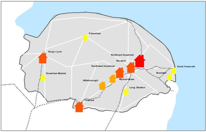
Table of Contents
INTRODUCTION ...............................................................................................................................................5
    FIGURE 1 KEY HOUSING GROWTH SITES ....................................................................................................................... 7
    FIGURE 2 KEY EMPLOYMENT SITES .............................................................................................................................. 8
    FIGURE 3 STRATEGIC INFRASTRUCTURE PROJECTS IN LOCAL AUTHORITY CONTROL................................................................ 9
FUNDING OPPORTUNITIES .............................................................................................................................11
FUNDED PROJECTS AT OCTOBER 2019 ...........................................................................................................14
SUPERFAST BROADBAND ...............................................................................................................................15
EDUCATION ...................................................................................................................................................18
INFRASTRUCTURE PROJECTS IN LOCAL AUTHORITY CONTROL .......................................................................21
ROADS ...........................................................................................................................................................25
    BROADLAND GROWTH TRIANGLE LINK ROAD.............................................................................................................. 26
    ATTLEBOROUGH LINK ROAD .................................................................................................................................... 28
    A10 WEST WINCH HOUSING ACCESS ROAD .............................................................................................................. 29
    A140 LONG STRATTON BYPASS ............................................................................................................................... 31
    FAKENHAM A148 ROUNDABOUT ENHANCEMENT ....................................................................................................... 33
    NORWICH WESTERN LINK ....................................................................................................................................... 34
RAIL ...............................................................................................................................................................36
    BROADLAND BUSINESS PARK RAIL STATION ................................................................................................................ 37
UTILITIES ........................................................................................................................................................38
    THETFORD ENERGY SUPPLY ..................................................................................................................................... 39
    ATTLEBOROUGH NEW EMPLOYMENT LAND – ELECTRICITY UPGRADE .............................................................................. 41
    SNETTERTON HEATH INFRASTRUCTURE - ELECTRICITY UPGRADE PHASE 2 ......................................................................... 42
SUSTAINABLE .................................................................................................................................................43
    WEAVERS WAY .................................................................................................................................................... 44
    THE GREEN LOOP .................................................................................................................................................. 45
    NORTH WEST WOODLANDS COUNTRY PARK .............................................................................................................. 46
EDUCATION ...................................................................................................................................................47
    BROADLAND GROWTH TRIANGLE SECONDARY SCHOOL................................................................................................. 48
INFRASTRUCTURE PROJECTS TO BE DELIVERED BY OTHER ORGANISATIONS .................................................49
    FIGURE 4 INFRASTRUCTURE PROJECTS TO BE DELIVERED BY OTHER ORGANISATIONS ............................................................ 50
ROADS ...........................................................................................................................................................51
    A11 THETFORD BYPASS JUNCTIONS ..................................................................................................................... 52
    A47 WISBECH BYPASS JUNCTIONS ....................................................................................................................... 54
    A47 TILNEY TO EAST WINCH DUALLING ............................................................................................................... 55
    A47 ACLE STRAIGHT DUALLING ........................................................................................................................... 56
RAIL ...............................................................................................................................................................57
    NORWICH TO LONDON RAIL (NORWICH IN 90) ..................................................................................................... 58
    GREAT YARMOUTH RAIL STATION ........................................................................................................................ 59
    ELY AREA ENHANCEMENTS .................................................................................................................................. 60
    EAST WEST RAIL (CAMBRIDGE TO OXFORD) ............................................................................................................ 61
UTILITIES ........................................................................................................................................................63
    SPROWSTON PRIMARY AND PEACHMAN WAY PRIMARY SUBSTATIONS ................................................................... 64

                                                                                  3
EARLHAM SUBSTATION ....................................................................................................................................... 65
   CRINGLEFORD PRIMARY SUBSTATION...................................................................................................................... 66
   BROADLAND GROWTH TRIANGLE TRUNK SEWER ...................................................................................................... 67
   WYMONDHAM WATER SUPPLY CONNECTIONS ....................................................................................................... 68
   KING’S LYNN SEWERAGE IMPROVEMENTS............................................................................................................. 69
   INCREASED SURFACE WATER CAPACITY NORTH LYNN............................................................................................ 70
SUSTAINABLE .................................................................................................................................................71
   GREAT YARMOUTH FLOOD DEFENCES 2017 ONWARDS (EPOCH 2) ........................................................................ 72
   FENS FLOOD PROTECTION ....................................................................................................................................... 74
UP AND COMING PROJECTS ...........................................................................................................................76

                                                                               4
Introduction

Norfolk County Council and its partners are determined to unlock
Norfolk’s full potential. To make this happen we are working together
to ensure existing and planned infrastructure links people to jobs,
homes and local amenities as well as connecting business with
customers. Work is already underway to achieve our social,
economic and environmental aspirations for today whilst making
Norfolk future fit for the challenges of tomorrow…

This strategic infrastructure delivery plan (SIDP) pulls together information on the
key infrastructure needed to deliver economic growth in Norfolk. It is a working
document that will be reviewed on a regular basis as information becomes
available and projects progress through to delivery. The Plan will help Norfolk
County Council and partners to co-ordinate implementation, prioritise activity and
respond to any funding opportunities. An online map showing all of the projects
and key information can be found: Norfolk Strategic Infrastructure Plan Map
All the information in the SIDP is correct as of the date of publication and will be
reviewed on a regular basis, the plan has been developed by assessing the work
required for each project to progress forward and where appropriate identify funding
opportunities to carry out this work.

     The Town and County Planning Association published (June 2018) a
       report: Building for the Future: The Role of County Councils in
     Meeting Housing Need. This report identified Norfolk County Council
         as a case study of best practice particularly highlighting the
      successes of the Norfolk Infrastructure Delivery Plan and Norfolk
     Strategic Planning Framework in future planning and collaboration.

The SIDP sets out the Norfolk wide high-level strategic infrastructure priorities for
the next 10 years. This list has been compiled in collaboration with stakeholders
including internal county council departments, district councils, utility companies
and government agencies. These projects align with the County Council’s priority
for improved infrastructure, the ambitions of the Norfolk and Suffolk Economic
Strategy (NSES), District Council Local Plans, the County Council’s plan “Together
for Norfolk – an ambitious plan for our County 2019-2025” priorities, Children’s
Services Local Growth and Investment Plan and the Norfolk Strategic Planning
Framework agreed by all Norfolk planning authorities.

                                           5
There are many other infrastructure schemes and projects important across the
county. Not every project can be included in the SIDP. The SIDP includes the most
strategic projects on which the county council alongside partners are actively
working to progress and which have a recognised route towards delivery.
Infrastructure projects in this delivery plan are appropriately in sync with the
Governments Industrial Strategy, which identifies growth as being clustered
around centres of skills and ideas. All of the projects will deliver the physical
infrastructure that is essential to promote these economic growth locations.
The projects included in the SIDP are now categorised into those where Local
Authorities lead the project and those where an external organisation is leading
and delivering the project. This still allows us to identify all the strategic
infrastructure projects in Norfolk but also direct resources, identify funding sources
and target lobbying in the most effective way as different projects will have
different routes through to delivery.
Some projects are further forward than others, so they have robust investment
figures and implementation timelines; others are in the early stages of design and
are less well known. In some cases, the funding sources are clear, where Section
106 (S106) or Community Infrastructure Levy (CIL) collected from developers will
provide a significant contribution. Additional details on costs and sources of funding,
such as contributions from utility companies like Anglian Water will be added as
projects are firmed up.
Figures 1 and 2 indicate that Norfolk’s key growth locations are clustered at points
along the main transport arteries. Therefore, these growth corridors and the
locations identified in the NSES and District Local Plans provide the spatial context
for this plan.
6Figure 1 Key housing growth sites
Housing Growth
TOTAL
8 1001 - 1500
8 1501 - 2501
8 2502 - 6001
8 6002 - 10001
7Figure 2 Key employment sites
8Figure 3 Strategic Infrastructure projects in Local Authority control
Broadland Business
Park Rail
Station
9The Norfolk Strategic Planning Framework suggests Norfolk authorities will need to
collectively plan for an additional 84,000 (approx. 4,000 per annum) homes by
2036. Figure 1 outlines the key strategic housing sites that will deliver the majority
of this growth, with growth focussed around key urban areas that have existing
infrastructure and services that have the capacity to support high levels of growth. It
also identifies all the places in our area that are expected to grow by at least 1,000
homes over the relevant local plan period. As well as the major urban areas of
Norwich, King’s Lynn and Great Yarmouth there are groupings of towns along the
A11 as well as key individual market towns that can make a significant contribution
to growth.
Figure 2 identifies the major employment sites and opportunities in Norfolk
crossing a range of sectors and locations. As with housing it shows the majority of
employment sites are aligned with the urban centres and access to the trunk road
network. The job growth locations have a diverse mix of high impact sector
activity, but the smaller locations have mainly advanced manufacturing and agri-
tech, with more life sciences in the southwest which is closer to Cambridge. There
are concentrations of employment locations serving high impact sectors in:
• Greater Norwich – Life sciences, digital cluster, finance and insurance
• Great Yarmouth – Offshore energy
• Attleborough, Thetford and A11 Corridor
• King’s Lynn and Downham Market – Advanced engineering
• Fakenham – Clean energy
Figure 3 shows all of the projects in Local Authority control that require further
development, it does not show projects that are funded, which are listed on page
12. These projects are in alignment with housing growth, jobs growth and NSES
key places, and will create better places to live and work for people in Norfolk. The
transport projects support major housing and employment sites; improving
connectivity and reducing journey times for people and businesses. Utility projects
are concentrated around urban areas and the towns along the A11, ensuring the
developments at Thetford, Attleborough and Snetterton are built out as planned,
and capacity for water supply and disposal is increased in Norwich and King’s Lynn
to accommodate growth. Utilities including digital coverage are now as essential for
homes and businesses as being able to turn a tap on and should be seen in the
same way with this plan identifying a range of projects that need to be progressed
to deliver the planned growth in NSES key locations. For the county to grow
sustainably, green infrastructure projects will mitigate the impact of growth to the
northeast of Norwich whilst flood defences and coastal erosion projects along the
coast will be vital in protecting both existing and future homes and businesses. The
projects do not work in isolation, and they deliver more than one outcome. The
transport projects are focussed on unlocking housing and job sites. These cannot
move forward without essential utilities being in place, while green infrastructure
projects create innovative solutions that can alleviate environmental constraints.
10Funding Opportunities
The funding required to pay for the strategic infrastructure projects to support
delivery of growth is a key element of the individual Local Infrastructure Plans.
Opportunities for funding include:
• Growing Places Fund
• City Deals
• Business Rates Pooling (BRP)
• Growing Business Fund
• Enterprise Zone accelerator fund
• Enterprise Zone business rates retention challenge fund
• Local Investment Fund (LIF)
• Local Major Transport Schemes
• New Anglia Local Enterprise Partnership (NALEP)
• Homes and Communities Agency
• Housing Infrastructure Fund
• Private Investment
• National Productivity Investment Fund (NPIF)
• Developer funding (Section 106 and Community Infrastructure Levy (CIL))
• Transforming Cities Fund
• Government Major Road Network
• Access for All
• Future High Streets Fund
• Sovereign Wealth
• Industrial Strategy related funding
In December 2013, Broadland, Norwich City, Norfolk County and South
Norfolk councils signed a City Deal with central government. A core theme
supports infrastructure delivery to promote accelerated delivery of planned
growth for infrastructure in Greater Norwich.
The infrastructure priorities identified in the IDP will assist the delivery of the
NSES and District Council Local Plan growth ambitions. This plan then sets out
which elements of infrastructure are required to support the identified growth
locations.
Housing Infrastructure Fund (HIF)
Norfolk has been successful in getting several schemes into the Homes England
Housing Infrastructure Funds. The funds allocated in Norfolk are:
Scheme Funding Works proposed Homes
agreed unlocked
Marginal viability fund (single and lower tier authorities)
Kingsfleet Urban £9.95m Power infrastructure 5,000
Extension, Thetford
Anglia Square, Norwich £12m Decontamination, 1,230
archaeology,
demolition, drainage, roads
11and parking, water,
electricals and gas
Cringleford, South Norfolk £7.8m Infrastructure (Homes 350
England’s Accelerated
Construction Fund.)
Forward funding (upper tier authorities)
Broadland growth triangle £57m Infrastructure 7,720
Total £96.7m 14,300
Transforming Cities Fund
Norfolk County Council, in partnership with Norwich City Council, Broadland District
Council and South Norfolk Council, has made an application to the Department for
Transport (DfT) as part of the Transforming Cities Fund through Transport for
Norwich. The fund aims to make it easier for people to access jobs, training and
retail, and also aims to respond to issues around air quality.
In September 2018, Greater Norwich was one of 10 city areas shortlisted to apply for
a share of the £840m grant. In the following budget announcement, this was
extended to 12 city areas and a £1.2bn total fund. The Transport for Norwich team is
now working with the DfT on detailed proposals to put forward for funding through
the project.
In January 2019, the partnership submitted a wish-list of schemes for funding from
an initial £60m pot to launch the project. Business cases for eight schemes made up
the £7m application and in March 2019, we were awarded £6.1m to deliver six of the
schemes:
• Improvements to Norwich Bus Station
• Continuation and completion of pedestrian, cycle and traffic flow
improvements to the Prince of Wales Road area, extending into Bank Plain
and London Street
• Cycle, pedestrian and highway improvements to the green pedalway in
Thorpe St Andrew
• Provision of an additional section of off-carriageway cycle path along the blue
pedalway in Hethersett
• Provision of a new cycle share scheme in Norwich
• Pedestrian access improvements at the Heigham Street/Mile Cross Road and
Dereham Road/Bowthorpe Road junctions, including provision of a 20mph
speed restriction in the residential areas between the junction
As outlined above we have already successfully secured a £6.1m allocation fund
from an earlier tranche of TCF funding and have outlined the following key
deliverables in the application for the remaining TCF allocation:
• Improvements along three principal transport corridors; Airport to Broadland
Business Park; Wymondham to Sprowston; and Easton to Rackheath
12• Quicker journeys by cleaner vehicles serving the Norwich Research Park,
University of East Anglia and the hospital, providing a cross valley link crossing
the River Yare
• More frequent bus services that are better co-ordinated between operators, with
more evening services
• Improvements to public transport ticketing
• Improvements to walking and cycling networks to support the delivery of
enhanced public transport
• Improvements to public transport, walking, cycling and general highway capacity
in the Longwater area
• More direct and quicker public transport routes to and from the Broadland
Growth Triangle, the UK’s largest urban extension
• Provision of much needed additional bus stop capacity in the city centre, better
connecting the train and bus stations and providing extra inner ring road junction
capacity
• Delivering fully accessible transport hubs that provide a range of facilities, which
could include seating, lighting, real time and disruption travel information, Wi-Fi,
mobile phone charging, cycle parking, electric vehicle charging, retail
opportunities and car club vehicles
Infrastructure Funding Statements
The Government recently (June 2019) set out amendments to the Community
Infrastructure Levy Regulations 2010, which introduces the requirement to produce
an Infrastructure Funding Statement (IFS), whereby Local Authorities set out their
infrastructure priorities and delivery as well as identifying (monitoring) how monies
received have been spent.
The County Council will need to work with the District Councils to ensure a joined-up
approach to infrastructure delivery through developer funding. This can build on
existing arrangements relating to the preparation of Local Authority Infrastructure
Delivery Plans.
The County Council already monitors effectively how it spends its Obligations
receipts – although further consideration will be given to this matter once further
Government Guidance is published.
13Funded Projects at October 2019
The following projects have successfully been funded since 2013
Completed:
• Broadland Northway (Norwich Northern Distributor Road (incl Postwick) -
£205m
• Norwich Pedal ways -£14m
• Great Yarmouth Beacon Park Link (A47/143 Link) - £6.8m
• A11 dualling Barton Mills to Thetford- £105m
• Great Yarmouth Right Turn at the rail station - £400,000
• Great Yarmouth Rail Station to the Market Place improvement- £2m
• Great Yarmouth sustainable transport package (Part 1) - £2.5m
• Thetford Enterprise Park Roundabout- £1.5m
• Bacton Walcott Sandscaping - £19.3m
• King’s Lynn Lynnsport Link Road- 3.5m
Under construction or part-completed:
• Attleborough Town Centre Improvements- £4.5m
• Snetterton Energy Supply - £3.6m
• Norwich (various projects including Dereham Road roundabout- £2m, Cycle
link extension to Wymondham- £1.3m, City centre Prince of Wales Road-
£2.6m, Dereham Road widening- £3m)
• A140 Hempnall Roundabout - £4m
• Great Yarmouth congestion-busting projects- £3.3m
• Great Yarmouth sustainable transport package (Part 2) - £3.5m
• Thetford Water Supply – £9.8m
• Thetford Sewerage Scheme - £2m
• Easton, Hethersett and Cringleford sewerage upgrade - £11m
Planned, not yet started:
• A11/ORR Daniels Road junction improvement- £2m
• Great Yarmouth Third River Crossing- £120m
• A47 improvements £2-300m (incl Thickthorn and Great Yarmouth junction
improvements and dualling Blofield to North Burlingham, and Easton to
North Tuddenham)
14Superfast Broadband
There are two infrastructure providers that have deployed fibre infrastructure capable
of delivering Superfast broadband (24Mbps+); BT Openreach and Virgin Media.
Commercial investment from these two companies provided access to Superfast
broadband for 42% of Norfolk properties. The Better Broadband for Norfolk (BBfN)
Programme signed a third contract in March 2019 and as a result coverage is
expected to increase access to Superfast broadband to 97% of Norfolk properties by
the end of September 2022.
To date, BBfN has seen access to Superfast broadband increase from 42% in 2013,
to 93% of Norfolk properties in March 2019. These figures are taken from the
independent organisation “Think Broadband” data.
Provisions within the BBfN contract provide rebates from BT if Take-up of services
using BBfN funded infrastructure are higher than expected. This has allowed
contract 3 to provide further funding to allow the county to move towards its aim of
achieving 100% coverage.
UK Digital Strategy
The Government has set-up the National Productivity Investment Fund (NPIF) to
provide over £23 billion of investment between 2017-18 and 2021-22. Investing in
priority areas including economic infrastructure, housing and research and
development. Of this money £740m will be invested in digital by 2020-21. This
investment is underpinned by the UK Digital Strategy which supports the next
generation of fast and reliable mobile and broadband communications for consumers
and businesses.
Broadband Delivery UK has re-branded as Building Digital UK (BDUK). It has
created an umbrella name for all it does UK Fibre Programme
Key areas include:
Full Fibre
The initial Government announced the first steps, specifically £200m investment to
leverage commercial investment in Full-Fibre, the ‘gold standard’ of fast and reliable
broadband. Complementing the NPIF programmes, the new Digital Infrastructure
Investment Fund will be launched in spring 2017. Government investment of £400m
will be at least matched by private sector investors and will accelerate the
deployment of Full Fibre networks by providing developers with greater access to
commercial finance.
Working with partners Norfolk County Council has secured circa. £8 million via the
Government’s Local Full Fibre network. This will provide Fibre to the Premises for
370 public sector sites, and importantly offers potential for nearby homes and
businesses to access via two new Government Gigabit Grant Schemes:
15Scheme for properties with speeds of less than 30Mbps
The Government has just announced a scheme for rural premises, experiencing
speeds below 30Mbps, properties will be eligible for between £500 and £3,500 per
small and medium-sized businesses (SME) and between £500 and £1,500 per
resident to support the cost of installing new gigabit-capable connections (Ultrafast).
https://gigabitvoucher.culture.gov.uk/rural/
Scheme for businesses, even if they currently have a speed above 30Mbps
Offers a grant of up to £2,500 per business to contribute to access to Ultrafast
broadband infrastructure, grants can be pooled, and any residential property which
can be covered will be eligible for up to a £500 contribution:
https://gigabitvoucher.culture.gov.uk/
The Government’s has set the aim of achieving access to Full Fibre broadband for
15 million properties by 2025 and all by 2033. It anticipates 90% of properties will
benefit from commercial investment from broadband infrastructure providers.
Broadband Delivery UK is currently working on possible options for providing Full
Fibre to the remaining 10% of properties.
5G
The Budget also announced up to £16m for leading UK research institutions to
cooperate on a cutting edge 5G facility to trial and demonstrate 5G technology. The
first step to a new National 5G Innovation Network, this will involve government
working as closely as possible with industry, investors, regulators, and researchers
to refine the Government’s policy as 5G technology emerges and evolves.
Support consumers in getting the best deal in digital connectivity
Ensuring adverts for broadband accurately reflect the speeds and technology
actually on offer for the majority of customers, so that people know what they are
getting and can better find the most competitive deal. The budget announced various
new ways to protect customer will be investigated.
Roll out free Wi-Fi on trains, and in more public places.
Providing access to free Wi-Fi whilst on the move.
Introducing a Broadband Universal Service Obligation
By 2020, the UK Government intends to introduce a Broadband Universal Service
Obligation (USO) that would give everyone a right to a decent broadband connection
on reasonable request. This is in recognition of the increasing importance of
broadband to people’s everyday lives. Ofcom recommendations for the USO have
set this at 10Mbps download speed and 1Mbps upload. More details are available
here: https://www.ofcom.org.uk/phones-telecoms-and-internet/advice-for-
consumers/broadband-uso-need-to-know
16Planning Regime reforms
Will support the mobile industry in the rapid rollout of 4G technology, to help reach
more people, more quickly.
The Electronic Communications Code
Regulates the telecommunications sector, reforms will put digital communications
infrastructure on a similar regime to utilities like electricity and water. The aim is to
ensure new technologies like 5G can be rollout out more quickly and benefit more
people.
Mobile connections
There are four main mobile operators in the UK; EE, O2, Three and Vodafone.
Coverage is increasing, based on a £2.5bn commercial investment which was
agreed between Government and these operators. This is expected to provide 90%
geographic voice coverage by the end 2017. However, the location of the 90% of UK
geography will be determined by the operators. During 2018, Ofcom are expected to
conduct a review of resulting coverage, this is expected to further inform future
government policy. Local Authorities want to work collaboratively to improve mobile
phone coverage in rural areas.
Local Industrial Strategy
The Local Industrial Strategy under Information and Communications Technology
and Digital Creative wants to develop the economic case for a Smart Emerging
Technology Institute and testbed (SETI) – a unique advanced high-speed optical and
wireless network (including 5G) which interlinks Internet of Things testbeds to
support large-scale experiments and data transfer.
17Education
The Schools’ Local Growth and Investment Plan (SLGIP) for pupil place provision
4- 16 sets out the strategic direction of pupil place supply for those areas of the
County where pupil numbers are expected to increase in the next 5-10 years. The
Plan is a response to the District Local Plan frameworks and is presented as the
basis for discussion, planning and decision-making for the County Council and its
partners across the increasingly diverse educational landscape. The Plan links to
the County Council’s schools’ forward capital programme which was reported and
approved at Committee in May 2018.
Major growth areas which will require multi-school solutions:
• Thetford Sustainable Urban Extension (SUE) of 5,000 new dwellings;
• Broadland Growth Triangle (Sprowston/Old Catton/Rackheath) of 12,000+
new dwellings; and
• Attleborough Sustainable Urban Extension (SUE) of 4,000 new dwellings.
Thetford
Primary School places within Thetford are provided by eight schools, a mix of
infant, junior and all-through primary, six of these are academies plus two
community schools. A total of 360 places are available each year group across the
primary phase.
Working with the land promotors on the strategic urban extension to Thetford, sites
have been secured free of charge for three new primary phase schools each of 420
places. In early 2018 the first reserved matters application for phase 1a of the
development was permitted for 343 dwellings. This phase includes the site for the
first new primary school with a potential opening date of 2021.
Pupil forecasts indicate that the current provision of places is sufficient until the new
housing commences. In the short term as described above land has been secured
for the first new school, in the longer term two further primary schools will be
delivered. The timescales for these schools depend on the progress rate of new
housing in Thetford.
Secondary school places will be monitored at Thetford Academy, as additional land
has already been provided at the school to allow for future expansion. S106
contributions have been secured although not yet collected as a result of the future
housing allocation.
Broadland Growth Triangle
Existing provision is extensive and affects three secondary schools: Sprowston
Community High School, Thorpe St Andrew School, Broadland Ormiston High
School and their feeder primary phase schools. Existing primary phase provision
remains a mix of infant/junior in Old Catton and Sprowston and all through primary
in Rackheath and Thorpe.
18To the immediate south-east, the new primary school at White House Farm is
progressing. Land has been transferred over to NCC and construction has begun.
The school opened in September 2019.
To the north of Old Catton progress is being made on several housing sites and
when coupled with the first phase of Beeston Park, the expectation is that there will
be pressure for school places in this area. Rackheath has a large allocation of for
up to 3,000-4,000 houses, which is progressing with a Housing Infrastructure bid
submitted in March 2019. Smaller sites around Rackheath are likely to commence
earlier with four sites of up to 700 homes in total are in the planning system.
Housing in this area will establish the need for many new schools and impact on
existing schools. There is a long-term plan for the area and sites have been
secured for new schools within the Local Plan. In the shorter-term admissions into
reception each year will be monitored.
As well as two new schools at Beeston Park, further school sites have been
secured for new schools on Salhouse Road, North of Smee Lane and a planned
extension to double the size of Little Plumstead Primary School. The major growth
in Rackheath also safeguards two new primary school sites.
Norfolk County Council has made a commitment for a new secondary phase
school in the Growth Triangle area and a preferred site has been identified on the
current Sprowston Park and Ride site. Some work on feasibility has taken place
but all options for additional secondary school places needs to be considered in the
area as a new secondary school project is currently unfunded. Norfolk County
Council continue to work with the Greater Norwich Growth Board to understand
how CIL can contribute to this major piece of work.
Attleborough
The town of Attleborough is served by two all-through primary schools, namely
Attleborough Primary School and the new Rosecroft Primary School and one
secondary school – Attleborough Academy. The two primary schools offer five
forms of entry between them. The town is surrounded by villages with local schools.
Some children in Attleborough catchment do choose a nearby village school as
opposed to their local primary school in the Town - e.g. in September 2018, around
22% of Attleborough catchment children expressed a preference for a reception
class outside catchment.
The outline planning application for 4,000 homes was recommended for approval at
Breckland District Council planning committee in March 2019. Heads of Terms for
the S106 agreement are still being finalised but land for two new primary phase
schools will be secured once outline permission is approved. Progress with the
development is subject to the link road so timescales for commencement of the
development once planning permission is granted are still uncertain.
In the short-term school places will be monitored through the annual admissions
19round. In the longer term there is planning for the provision of two new primary
schools for Attleborough understanding the parental preference to surrounding
villages and how that will impact on the new schools.
In addition to these major growth areas which require multi-school solutions the
SLGIP also sets out development locations where one new school is expected and
growth areas with implications for existing schools. The full report can be found:
https://norfolkcc.cmis.uk.com/norfolkcc/Meetings/tabid/128/ctl/ViewMeetingPublic/
mid/496/Meeting/1474/Committee/8/Default.aspx
20Infrastructure projects in
Local Authority Control
Key Infrastructure Projects
21
Page 13 of 63Infrastructure Projects in Local Authority control
The County Council in collaboration with partners is seeking to progress a number
of key infrastructure initiatives for the next 10 years as listed below.
All of the projects in this list are judged on four criteria:
• Delivering significant housing and jobs growth
• Identified in existing plans/programmes
• Have a committed route to delivery
• Significant Local Authority control or interest.
Tick system key:
No ticks = Issue identified but no work carried out to identify project/solution
✓= Feasibility work on scheme has begun to identify options
✓✓= Feasibility/development work underway on preferred option
✓✓✓= Project is shovel ready
Road Projects
Project Estimated Estimated Scheme Potential
Name Start Date Cost Development Funding
Source
Broadland 2021 £38m Developer funding,
Growth ✓✓✓ CIL, BRP, HE HIF
Triangle Link
Road
Attleborough 2021 £18m Developer funding,
Link Road ✓✓ NALEP
A10 West 2022 £32m Developer funding,
Winch NALEP, Government
Housing ✓✓ Major Road Network
Access Road
A140 Long 2022 £33m Developer funding,
Stratton ✓✓ NALEP, CIL, NPIF,
Bypass Government Major
Road Network
22A148 2022 £3.5m ✓✓ NPIF, NALEP
Fakenham
Roundabout
Enhancement
Norwich 2023 £153m NALEP, Local major
Western Link ✓✓ transport scheme
Rail Projects
Project Estimated Estimated Scheme Potential
Name Start Date Cost Development Funding Source
Broadland Mid 2020s £6.5m ✓ NALEP, Rail Industry
Business
Park Rail
Station
Utilities Projects
Project Estimated Estimated Scheme Potential
Name Start Date Cost Development Funding
Source
Thetford 2019 £10m- HCA, HE HIF
Enterprise
SUE £12m ✓✓✓ (secured
Energy
Supply
Thetford 2020 £1m BRP, NALEP,
SSUESUE
Enterprise ✓ Private Sector
Park
Energy
Supply
Attleborough 2020 TBC ✓ BRP, NALEP,
New Private Sector
Employment
Land –
Electricity
Upgrade
Snetterton 2020 TBC ✓ NALEP,
Heath Private Sector
Infrastructure
- Electricity
Upgrade
Phase 2
23Sustainable Projects
Project Estimated Estimated Scheme Potential
Name Start Date Cost Development Funding Source
Weavers Way 2019 £3.1m RDPE, HLF, NALEP
✓✓
The Green 2019/20 £5.8m DfT, NALEP, Sustrans,
Loop ✓✓✓ Lottery, Developer
contributions, CIL
North West 2022 £2m ✓ Broadland District
Woodlands Council, CIL, BRP
Country Park
Education Projects
Project Estimated Estimated Scheme Potential
Name Start Date Cost Development Funding Source
Broadland 2025/26 – £26m NCC, BRP, CIL
Growth dependent on ✓
Triangle development
progress
Secondary
School
24Roads
Accessible
25
Page 19 of 63Broadland Growth Triangle Link Road
The project will provide a road linking the strategic employment areas of Broadland Business Park and Norwich Airport through the
development sites within the northern suburbs of Norwich. It will significantly increase the accessibility of employment sites in the
Broadland Growth Triangle area and support the development of approximately 55 hectares of employment land in this vicinity. A
section of the link between Wroxham Road and Salhouse Road has already been delivered through development and is expected
to be open to traffic in the near future. The remaining sections are outlined below.
Broadland Growth Triangle Norwich Link Road
St Faiths Road to North
Plumstead Road to
Airport Industrial Estate to Walsham Road and North Salhouse Road to
Description of stage Broadland Business
St Faiths Road Walsham Road to Plumstead Road
Park
Wroxham Road
Possible need for
Additional feasibility and Additional feasibility and
Estimated cost to additional feasibility and
scheme development scheme development n/a
deliver the stage scheme development
costing approx. £200k costing approx. £500k
costing approx. £300k
Feasibility underway to A detailed application has Outline planning Developer current
establish optimal location, been submitted part of the permission for intention is to begin
nature and timing of link between St Faiths development scheme constructing 1st phase of
vehicular link to Airport - Road and Norwich RFU. across majority of link the Brook Farm Link
completion by March NCC and BDC are granted. Reserved matters Road by the end of
2019. Scheme working with the developer application submitted for 2019.
Indicative timeframe development and planning to achieve a planning link between Salhouse
applications to follow as approval. Approval Road and triangle land. BDC and NCC are in
to deliver stage and
appropriate. anticipated by March 2020 Scheme for signals on ongoing negotiations
start date
and delivery by March Salhouse Road submitted with developer about 2nd
Developer on site and 2021. and delivery anticipated by phase of link road.
delivering estate road link March 2020.
with mini roundabout on NCC, BDC and developer Key constraint is Middle
Repton Avenue. are working through the Detailed consent for Road Bridge. Scheme
Temporary construction co-development of the HIF junction with Plumstead for widening and
link between Repton bid to develop scheme for Road currently under- improving presently part
26Avenue and Meteor Close remainder of link. If HIF is consideration. of funding bid.
has been constructed. successful delivery is Roundabout junction
Work on a permanent link expected by March 2021. subject to funding bid.
between Repton Avenue
and Meteor Close still to
start. Construction
complete by March 2020.
Potential funding CIL, BRP, HIF, developer CIL, HIF, developer
CIL, developer finance Developer finance
source finance finance
Tick system ✓✓✓ ✓✓✓ ✓✓✓ ✓✓✓
27Attleborough Link Road
A key transport priority for Attleborough, required for planned strategic growth, is a link road between the B1077 near Bunns Bank
to London Road to the south of the town. The link road will distribute new and existing traffic away from the town centre and enable
traffic management measures to be implemented within the town centre such as HGV restrictions. Delivery of the link road will be
a planning requirement of the scheme and will be phased so that up to 1,200 homes can be built before the link road is required to
be opened in full. A Planning Application for the Urban Extension including the link road was submitted in 2017 and was
determined in 2019. Discussions are ongoing with development interests and key partners in order to bring forward the full
completion of the road before the requirements of the planning obligations are triggered.
Attleborough Link Road
Development phase: Preliminary Design; Statutory procedures
Description of stage Construction phase
and powers; Construction preparation
Estimated cost to deliver
Circa £1.4m £14m
the stage
Indicative timeframe to
Two years
deliver stage and start date
BRP, developer, NALEP, Homes
Potential funding source BRP, local authority, developer
England loan, HIF
Required for 4,000 new houses and 1,500 new jobs. Strategic Required for 4,000 new houses
Qualifications for BRP and scheme identified in the IDP. Funding would be for detailed and 1,500 new jobs. Strategic
or NALEP funding technical work designed to progress strategic schemes towards scheme identified in the IDP.
readiness for implementation. Funding would be for construction.
Tick system Completion of this stage will take from ✓✓ to ✓✓✓
28A10 West Winch Housing Access Road
To facilitate planned housing growth in West Winch a new road is required between the A47 and A10 to enable distribution of trips
from the new development and to alleviate congestion on the A10 through West Winch and at the Hardwick junction. In order to
protect the existing A10 from increased traffic, a new route through or around the new development in this quadrant is proposed in
the Borough Council’s Core Strategy and Local Plan.
As outlined above the A10 West Winch Housing Access Road is intrinsically linked to some improvements at the Hardwick junction
and the need to dual a short length of the A47. These other measures will form part of the overall West Winch Housing Access
Road scheme. Work carried out by Mott MacDonald in 2014 indicated some £22.8m for the total package of these measures.
A10 West Winch Housing Access Road
Stage 1: Scheme Stage 2: Preparation of
Description of stage Detailed design and procurement
development planning application
Estimated cost to
£280k Est. £770k Est. £1.9m
deliver the stage
Indicative timeframe to
deliver stage and start Jan- Dec 2018 Jan-Dec 2020 2020
date
Potentially BRP, local authority funding match,
developer contribution. DfT Major Road Network
(The scheme has been prioritised by Transport
Being funded by East. NCC submitted a draft Strategic Outline
Being funded by BRP, NCC
Potential funding source BRP, NCC and Business Case to DfT in July 2019. DfT have
and KLWNBC
KLWNBC requested further information and a funding
decision likely to be sometime in 2020/21).
A funding decision is expected on the first tranche
of national projects at the end of 2019. A positive
29
funding decision would see construction of the
road start in 2022.)Completion of this
Initial stage to take from ✓✓ to
Tick system stage will take it from ✓ Completion of this stage will take it to ✓✓✓
✓✓✓
to ✓✓
30A140 Long Stratton Bypass
Long Stratton is located approximately 10 miles south of Norwich on the A140 Norwich to Ipswich road. There is planned growth
in Long Stratton of at least 1,800 homes in the period 2008-2026 to deliver a bypass but this growth is also highly dependent on
the provision of water supply, sewerage and improved electricity supply. The need for a bypass has long been a priority and is
considered to be a prerequisite to provide for the needs of the proposed growth. South Norfolk District Council has adopted an
Area Action Plan (AAP) for Long Stratton and a planning application was submitted by the developer in 2018. This is expected to
be determined in early 2019.
A140 Long Stratton Bypass
An economic viability study for the Long
Stratton bypass. This will be carried out Development phase:
by an expert consultant to provide a Preliminary Design;
professional opinion on the: Statutory procedures and
Description of stage estimated cost of the bypass; powers; Construction Construction phase
estimated funding gap; preparation NB: This work
direct and indirect economic benefits of could be broken down into
the bypass; and added benefits of the three above phases
early delivery of the bypass
Estimated cost to
£200,000 (funded) Circa £4m
deliver the stage
312022 start on bypass
DfT Major Road Network (The scheme
has been prioritised by Transport East.
A funding decision is expected on the
Indicative
first tranche of national projects at the
timeframe to
Dec 2017 to July 2018 Two years end of 2019. A positive funding
deliver stage and
decision would see construction of the
start date
road start in 2022.)
2019 Hempnall Crossroads (under
construction following successful NPIF
bid by the county council in 2018)
Funded from:
Pooled Business Rates: £100,000
Potential funding BRP, Developer, NALEP, HIF,
SNC: £15,000 BRP, local authority, developer
source Government Major Road Network
HCA: £35,000
NCC: £50,000
Required for 1,800 new
houses and to overcome
traffic problems on A140. Required for 1,800 new houses and
Qualifications for Strategic scheme identified in to overcome traffic problems on
BRP and or the IDP. Funding would be for A140. Strategic scheme identified in
NALEP funding detailed technical work the IDP. Funding would be for
designed to progress strategic construction
schemes towards readiness
for implementation
Completion of this stage
Tick system Will take scheme from ✓ to ✓✓ will take it from ✓✓ to
✓✓✓
32Fakenham A148 Roundabout Enhancement
A planning application has been received for 950 residential dwellings adjacent to and south of the A148 between Water Moor Lane
and the Morrisons roundabout to the east. Access to the new residential development is proposed via a new roundabout on A148
(at the Water Moor Lane junction) with a link road through to the existing roundabout serving Morrisons. There are longer term
aspirations to take forward housing allocations adjacent and beyond the A148 at this location. As Highway Authority Norfolk County
Council has indicated that a roundabout would be required to be built at the current A148/B1105 junction as a condition of the
planning permission if residential development to the west of Water Moor Lane is progressed.
Fakenham A148 Roundabout Enhancement
Development of planning
Description of stage application including time for Acquisition of land Utilities diversion Construction phase
statutory consultation of 13 weeks
Estimated cost to
TBC TBC TBC Estimated £3.5m
deliver the stage
18 Months – To develop planning
application and supporting
Indicative timeframe 9 months – to deliver
documentation including 6 months
to deliver stage and and implement any 5 months
environmental assessment,
start date required utility diversions
ecological and arboricultural
surveys.
Potential funding
NPIF, NALEP NPIF, NALEP NPIF, NALEP NPIF, NALEP
source
Qualifications for BRP
Required to support the delivery of one of North Norfolk’s largest Local Plan allocations of 950 dwellings
and or NALEP funding
Tick system ✓✓ ✓✓ ✓✓ ✓✓✓
33Norwich Western Link
This link – to connect the Broadland Northway at Taverham to the A47 west of Norwich – has been identified as one of the
county council’s priority road infrastructure schemes. Scheme development work has commenced, looking at the business case
for such a link and to consider possible routes. The County Council has recently consulted on this project and there is a
significant amount of public support for the project.
Norwich Western Link
Development phase: Preliminary
Option development and initial appraisal
Design; Completion and submission of
Development of business case: progress
Outline Business Case; Statutory
Description of stage Design; Environmental assessment; Construction phase
procedures and powers; Procurement
Traffic modelling; and economic
and Detailed Design for Construction
appraisal
preparation
Estimated cost to
£1m £10m Indicative £160m
deliver the stage
Three years (2019-2022)
-(2019/2020) Prelim Design and OBC
development submission - £3m
Indicative timeframe
-(2020 – 2022) Statutory process
to deliver stage and Feb 18- Dec 18 Two years (2022 to 2024)
(development and delivery) - £4m
start date
-(2021-2022) Procurement and
detailed design/construction prep -
£3m
34NALEP, local major
Funded from BRP (£500k) and NCC BRP, NALEP, local major
Potential funding source transport scheme,
(£500k) transport scheme, local authorities
local authorities
Strategic scheme
identified in the IDP.
• Support sustainable
Strategic scheme identified in the IDP. housing growth in the
• Support sustainable housing growth in the western quadrant western quadrant
• Improve the quality of life for local communities • Improve the quality of life
• Support economic growth for local communities
Qualifications for BRP • Protect and enhance the natural environment • Support economic
and or NALEP funding • Improve strategic connectivity with the national road network growth
• Protect and enhance the
Funding for detailed technical work designed to progress strategic schemes natural environment
towards readiness for implementation • Improve strategic
connectivity with the
national road network
Funding would be for
construction
Tick system Will take scheme from ✓ to ✓✓ Will take scheme from ✓✓ to ✓✓✓
35Rail
Serviced
36
Page 46 of 63Broadland Business Park Rail Station
Currently services operate every hour between Norwich and Sheringham. New rolling stock will be delivered across the whole of
the franchise between 2018 and 2020. Further capacity improvements are required to accommodate passenger demand and the
County Council has been pressing for services every half hour (rather than hourly). Broadland Business Park is a strategic
employment site located adjacent to the rail line just east of Norwich. Work to establish the benefits of adding a new station at this
location is ongoing.
Broadland Business Park Rail Station
Feasibility GRIP
Development phase: Preliminary Design;
Description 2 and option Construction
Further work to develop single option Statutory procedures and powers;
of stage selection GRIP phase
construction preparation
3
Estimated cost
to deliver the £140k Not known. Likely to be Circa £250,000 Circa £2m Circa £20m
stage
Indicative
timeframe to 2018 2019-2022 Circa 2027
Dec 17
deliver stage 1 year 3-5 years 1 year
and start date
Funded through
Potential BRP and
BRP, local authorities BRP, Growth Deal, local authorities
funding source Broadland
District Council
Strategic
Strategic scheme identified in the IDP. Strategic scheme identified in the IDP. scheme
Qualifications Strategic
Funding would be for detailed technical Funding would be for detailed technical identified in
for BRP and or scheme
work designed to progress strategic work designed to progress strategic the IDP.
Growth Deal identified in the
schemes towards readiness for schemes towards readiness for Funding
funding IDP.
implementation implementation would be for
construction
Tick system ✓ To take scheme from ✓ to ✓✓ To take scheme from ✓✓ to ✓✓✓
37Utilities 38
Thetford Energy Supply
A major 5,000 unit housing development (Thetford SUE) which commenced on site in spring 2018 with the first 343 units now in
contract. This first phase will substantially use the current spare electricity capacity power in the north of Thetford. A phased
approach to increasing electricity capacity is proposed with the first phase being the building of a new Primary Substation to be
located on the Thetford SUE and serving the housing development, a large employment area on the SUE and an adjacent large
employment area known as the Thetford Enterprise Park. The two employment sites have a joint capacity for circa. 140,000sq m
of B1, B2 and B8 development and potential to create 3,600 jobs.

                             Thetford SUE                                          Thetford Enterprise Park
 Description of stage        11MVA of power already reserved under contract        Phase 1: Secure 1MVA from UKPN to support first
                             with UKPN.                                            development.
                             Construction of a new 33kV primary electricity sub-
                             station on the SUE in northern Thetford               Phase 2: Distribution of power from the new
                                                                                   substation to the Thetford Enterprise Park
                                                                                   employment site as part of a northern Thetford
                                                                                   upgrade of the 11kV distribution system.

 Estimated cost to           £6.5m                                                 £1m
 deliver the stage
 Indicative timeframe to     2½ years                                              Phase 1 - 1MVA of power available within 6
 deliver stage and start                                                           months, subject to contract (to support first
                             Start date: 2019
 date                                                                              development) BRP funded.
                                                                                   Phase 2 - 2 years
                                                                                   Start date: 2020 subject to funding

 Potential funding source    HCA HIF (secured)                                     BRP, NALEP, Private Sector

                                                                   39
Qualifications for BRP To accelerate housing delivery and provide a source Required to unlock the TEP employment
and or NALEP funding of power for the TEP site
Tick system ✓✓✓ ✓
40You can also read