Assessing local impacts of the 1700 CE Cascadia earthquake and tsunami using tree-ring growth histories: a case study in South Beach, Oregon, USA
←
→
Page content transcription
If your browser does not render page correctly, please read the page content below
Nat. Hazards Earth Syst. Sci., 21, 1971–1982, 2021
https://doi.org/10.5194/nhess-21-1971-2021
© Author(s) 2021. This work is distributed under
the Creative Commons Attribution 4.0 License.

Assessing local impacts of the 1700 CE Cascadia
earthquake and tsunami using tree-ring growth
histories: a case study in South Beach, Oregon, USA
Robert P. Dziak1 , Bryan A. Black2 , Yong Wei3 , and Susan G. Merle4
1 NOAA/Pacific   Marine Environmental Laboratory, Newport, Oregon, 97365, USA
2 Laboratory of Tree-Ring Research, University of Arizona, Tucson, Arizona, USA
3 NOAA/Pacific Marine Environmental Laboratory, Seattle, Washington, 98115, USA
4 Cooperative Institute for Marine Resources Studies, Oregon State University, Newport, Oregon, 97366, USA

Correspondence: Robert P. Dziak (robert.p.dziak@noaa.gov)

Received: 5 January 2021 – Discussion started: 27 January 2021
Revised: 27 May 2021 – Accepted: 28 May 2021 – Published: 30 June 2021

Abstract. We present an investigation of the disturbance his-     1   Introduction
tory of an old-growth Douglas-fir (Pseudotsuga menziesii)
stand in South Beach, Oregon, for possible growth changes         Recent studies have demonstrated the utility of using tree-
due to tsunami inundation caused by the 1700 CE Casca-            ring growth chronologies for assessment of tsunami and
dia Subduction Zone (CSZ) earthquake. A high-resolution           earthquake impacts on coastal environments (Buchwal and
model of the 1700 tsunami run-up heights at South Beach,          Szczucinski, 2015; Kubota et al., 2017; Wang et al., 2019).
assuming an “L”-sized earthquake, is also presented to bet-       Catastrophic tsunami inundation events along the Sumatran
ter estimate the inundation levels several kilometers inland at   and Japanese coasts have shown tsunamis can have a dev-
the old-growth site. This tsunami model indicates the South       astating effect on coastal forests and overall coastal geo-
Beach fir stand would have been subjected to local inunda-        morphology (Kathiresan and Rajendran, 2005; Udo et al.,
tion depths from 0 to 10 m. Growth chronologies collected         2012; Lopez Caceres et al., 2018). In addition to the phys-
from the Douglas-fir stand shows that trees experienced a sig-    ical impacts from tsunamis, Kubota et al. (2017) showed
nificant growth reductions in the year 1700 relative to nearby    that coastal trees that survived direct physical damage from
Douglas-fir stands, consistent with the tsunami inundation        the great 2011 Japanese tsunami began to die the follow-
estimates. The ±1–3-year timing of the South Beach distur-        ing summer likely due to the physiological stress of saltwa-
bances are also consistent with disturbances previously ob-       ter immersion. Wang et al. (2019) performed a regional as-
served at a Washington state coastal forest ∼ 220 km to the       sessment of coastal western Washington forests and demon-
north. Moreover, the 1700 South Beach growth reductions           strated that seawater exposure drives reductions in growth,
were not the largest over the > 321-year tree chronology at       increased mortality, and greater climate sensitivity regardless
this location, with other disturbances likely caused by cli-      of whether the seawater exposure is recent or long-term.
mate drivers (e.g., drought or windstorms). Our study repre-         Ground motion caused by the megathrust earthquake can
sents a first step in using tree growth history to ground truth   also cause significant forest disturbance by toppling trees,
tsunami inundation models by providing site-specific physi-       damaging root systems, severing limbs and crowns, inducing
cal evidence.                                                     damaging landslides, or altering the hydrology of a stand,
                                                                  among other potential effects (e.g., Sheppard and Jacoby,
                                                                  1989). These disturbances appear in the tree-ring record of
                                                                  surviving trees as sudden growth suppression events (when
                                                                  there is damage) or growth increases in the case of reduced
                                                                  competition from adjacent damaged trees.

Published by Copernicus Publications on behalf of the European Geosciences Union.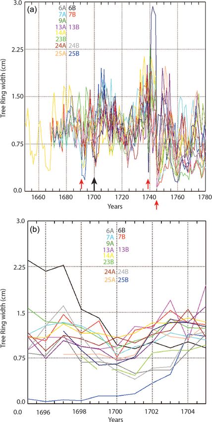
1972                             R. P. Dziak et al.: Assessing local impacts of the 700 CE Cascadia earthquake and tsunami

Figure 1. Map showing location of Newport and South Beach along the central Oregon coast. The white dot (at an elevation of 4 m above
mean higher high water, MHHW) shows the position of Mike Miller State Park in South Beach, which is the location of the Douglas-fir tree
(Pseudotsuga menziesii) old growth stand whose ages extend back past 1700 CE. The state park is located ∼ 2 km south of the Yaquina Bay,
Newport, ∼ 1.2 km east of the shoreline and ∼ 600 m east of Highway 101. Maps were created using digital elevation data points complied by
the National Center for Environmental Information (http://ncei.noaa.gov, last access: September 2020) and the State of Oregon’s Department
of Geology and Mineral Industries (https://www.oregongeology.org/lidar/, last access: September 2020).

   Here we present an investigation of the disturbance                 climate reconstructions from high-elevation sites in the Cas-
history of an old-growth forest in South Beach, Oregon                 cade Mountains and Olympic Peninsula where competitive
(Fig. 1). We also present a new, high-resolution model of the          effects are relatively lower. We sampled a mesic old-growth
1700 tsunami run-up heights at South Beach to better esti-             forest near the Pacific coast where competitive effects are
mate the inundation levels at the site of the old-growth for-          high. Significant disturbances from the 1700 earthquake and
est. Our goal is to use tree growth to ground truth the tsunami        tsunami should substantially alter radial growth patterns as
impacts and inundation levels, as well as for insights into the        some trees are damaged or killed and resources are redis-
degree of shaking caused by the 1700 magnitude 9.0 Casca-              tributed to survivors. Alternatively, the tsunami may cause
dia Subduction Zone (CSZ) earthquake (Satake et al., 2003;             physical damage to trees resulting in growth reductions. The
Witter et al., 2011).                                                  goal of this study is to investigate whether these disturbances
   Interestingly, direct evidence of seismic shaking (liquefac-        are observable in the few remaining old-growth forests along
tion, landslides, etc.) from the 1700 CSZ earthquake is rela-          the coast of Oregon. Thus, we chose a site where good in-
tively rare along the Oregon Coastal Range (Struble et al.,            undation models exist and where there is significant public
2020). This is thought to be due to the high rainfall and wa-          concern about tsunami impacts because of the presence of a
ter erosion rates in the Pacific Northwest which removes liq-          large population (> 10 000 people) and municipal infrastruc-
uefaction evidence in coastal estuaries and makes landslides           ture.
in the coast range difficult to identify (Yeats, 2004; LaHusen
et al., 2020). Models of shaking and ground motion along
the Oregon coast during the 1700 CSZ earthquake indicate it            2   Evidence for megathrust earthquakes and tsunamis
should have been violent and widespread (WDNR, 2012),
                                                                       On 26 January at 21:00 PST (Pacific standard time),
and it is plausible that evidence of this shaking might be
                                                                       1700 CE, a large earthquake occurred along the Cascadia
recorded in the form of traumatic resin ducts and ring width
                                                                       Subduction Zone, the interface between the Pacific and North
suppression of trees along the coast. Very little tree-ring work
                                                                       American plates along the coasts of California, Oregon,
has been conducted along the Oregon coast; the vast major-
                                                                       Washington, and British Columbia (Satake et al., 2003). The
ity of tree-ring research in the Pacific Northwest has entailed
                                                                       earthquake created a tsunami with 10–12 m run-up heights

Nat. Hazards Earth Syst. Sci., 21, 1971–1982, 2021                                      https://doi.org/10.5194/nhess-21-1971-2021
R. P. Dziak et al.: Assessing local impacts of the 700 CE Cascadia earthquake and tsunami                                    1973

that struck the Pacific Northwest and propagated across the         3   Model of 1700 CE tsunami
Pacific to Japan (Atwater, 1992; Satake et al., 2003; Goldfin-
ger et al., 2003). It is estimated to have most likely been a mo-   As a first step in estimating tree disturbance in South Beach,
ment magnitude (Mw ) 9.0, with between 13 and 21 m of co-           we produced a model of the tsunami inundation level and
seismic slip on an offshore fault 1100 km long (Satake et al.,      expected flow speed for the 1700 earthquake based on esti-
2003; Witter et al., 2011). The 1700 earthquake was preceded        mates of size, location, displacement, and coastal subsidence
by an earthquake in ∼ 960 CE (740-year interval) and an-            (Fig. 2a–c; Witter et al., 2011). Thus, the modeled run-up
other in ∼ 750 CE (210-year interval), with three additional        height of the 1700 tsunami can be used as a basis to investi-
subduction events before these that make up a recent cluster        gate possible impacts along the coast and estuaries of South
of six megathrust events over the past 1500 years (Atwater et       Beach. Figure 2a and b show the model results of tsunami in-
al., 2003). During the 1700 Cascadia earthquake, ground mo-         undation level and flow speed for South Beach assuming the
tion and peak ground acceleration (PGA) are modeled from            “L”- or large-sized earthquake (Mw = 9.0) for the 1700 CE
∼ 0.5 to 1.2 g along the Oregon coast (WDNR, 2012). Thus            event (Wei, 2017). The L model assumes a finite-fault source
the shaking during this event would have been violent and           with maximum vertical coseismic displacement of 15.2 m
widespread.                                                         and subsidence of ∼ 1.03 m at South Beach (Fig. 2c; Witter
   As a result of subsidence, some coastal forests dropped          et al., 2011). The Witter et al. (2011) coseismic subsidence
below sea level and were flooded. Boles and root masses             estimate differs slightly from the Satake et al. (2003) esti-
of these trees still remain and can be found from northern          mate of nearly 1 m at South Beach because it is based on
Oregon to southern Washington. Radiocarbon dating of this           coseismic slip from turbidite records (Goldfinger, 2011) and
wood showed the earthquake occurred around 1700. How-               includes a rupture model with slip partition into a splay fault
ever, aligning growth patterns of adjacent living trees with        in the accretionary wedge. The earthquake source duration
those of the flooded, dead trees consistently showed that the       was not taken into account in the model.
last year of growth was 1699, indicating the earthquake oc-            Two models were used to compute the tsunami inun-
curred between October 1699 and April 1700 (Yamaguchi               dation levels and flow speed (Wei, 2017) based on four-
et al., 1997). The exact origin time of the earthquake was          level one-way nested model grids at the spatial resolu-
estimated by calculating the travel time for an unexplained         tions of 1 arcmin (∼ 1.8 km), 12 arcsec (∼ 360 m), 2 arcsec
tsunami that struck Japan on 26 January 1700 (Satake et al.,        (∼ 60 m), and 1/6 arcsec (∼ 5 m). The tsunami simulation
2003; Atwater et al., 2006). Surviving trees also recorded          model MOST (Method of Splitting Tsunami) (Titov and
the earthquake’s date by anomalous changes in ring width            Gonzalez, 1997) used in this study is based on the shallow-
or wood anatomy (Atwater and Yamaguchi, 1991; Jacoby et             water wave equations and uses the estimates of coseismic
al., 1997). This tree-ring and dating evidence for coastal dis-     slip to account for deep-water wave generation and propa-
turbance is indeed compelling; however, the evidence was            gation. The present MOST code version utilizes the graph-
derived from trees along just 100 km of coastal southern            ics processing unit (GPU) technology that has led to signifi-
Washington and northern Oregon or ∼ 5 % of the coastline            cant reduction of computational time. The MOST model then
expected to be affected by a Cascadia megathrust earthquake.        provides the boundary conditions computed from the level-
   Additional methodologies have been employed to assess            1 grid (Fig. 2a) for a Boussinesq model (Zhou et al., 2011),
the coastal-wide impacts of the 1700 earthquake. For exam-          which takes into account wave dispersion when computing
ple, a coastal-wide inventory of liquefaction features associ-      the nearshore wave-propagation field and onshore tsunami
ated with the 1700 earthquake found no features along the           inundation in level-2, level-3, and level-4 grids (Fig. 2b
Oregon coast despite numerous exposures of clean sand de-           shows the coverage of level-4 grid). The digital elevation
posits that must be susceptible to liquefaction, even at low        model (DEM) and bathymetric grid of Newport and South
levels of seismic shaking (Obermeier and Dickenson, 2000).          Beach in level 4 were used in the tsunami inundation models.
The locations for these field studies in Oregon were also sites     The elevation grid is derived from the digital elevation model
where evidence for great Holocene subduction earthquakes            provided by the Oregon Department of Geology and Min-
(in the form of crustal subsidence) have been identified (Nel-      eral Industries (DOGAMI). This dataset contains lidar data
son et al., 1995). The only liquefaction features identified        based on DOGAMI lidar data quadrangles for Toledo south,
to date (and thus direct evidence of seismic shaking) were          Newport north, and Newport south. The horizontal datum of
found along the Columbia River 35–50 km east of the coast,          the DEM is WGS 84. The vertical datum is NAVD 1988,
and these indicate moderate shaking intensity of 0.2–0.35 g         and it is then converted to mean higher high water (MHHW)
(Obermeier and Dickenson, 2000).                                    level, which is the vertical datum in our tsunami inunda-
                                                                    tion models. MHHW is 2.317 m above the NAVD 1988 and
                                                                    1.185 m above the actual mean sea level (MSL) at Newport
                                                                    according to the datum information at the National Ocean
                                                                    Service (NOS) tide gauge at South Beach. Typically, when
                                                                    performing hazard assessments, mean high water (MHW)

https://doi.org/10.5194/nhess-21-1971-2021                                 Nat. Hazards Earth Syst. Sci., 21, 1971–1982, 2021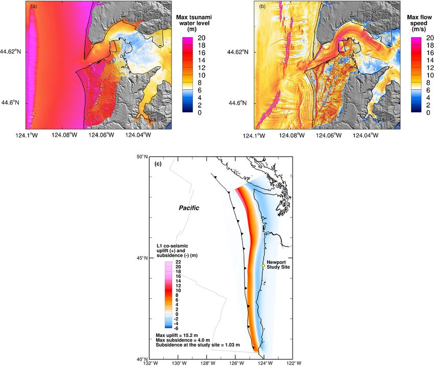
1974                            R. P. Dziak et al.: Assessing local impacts of the 700 CE Cascadia earthquake and tsunami

Figure 2. (a, b) Model of the maximum tsunami inundation level and the maximum flow speed for South Beach assuming the L- or large-
sized earthquake (Mw = 9.0) for the 1700 CE event (Wei, 2017). The L model assumes a finite-area fault source with maximum coseismic
displacement of 15.2 m and subsidence of ∼ 1.03 m at South Beach. Contour levels are shown. (c) The L model assumes a finite-area fault
source with maximum coseismic displacement of 15.2 m and subsidence of ∼ 1.03 m at South Beach (Witter et al., 2011).

or MHHW is assumed over the entire duration of a tsunami              0.033) and for land surface (0.03–0.04). It is worth noth-
(Wei, 2017), and using MHHW as the vertical datum usually             ing that this Manning’s coefficient has been widely used in
gives a more conservative estimate of the tsunami impact. In          MOST-based tsunami model forecast methodology and haz-
the present study, we prefer to use MHHW, instead of the ac-          ard assessments (Tang et al., 2009; Wei et al., 2008, 2013;
tual tidal level, as our model reference level due to (1) the un-     Titov et al., 2016; Zhou et al., 2011). To more realistically
certainty of the time of the event, which is based on estimates       estimate the tsunami impact produced by the 1700 event, we
from Japanese records (Satake et al., 1996) and could vary            removed the two jetties at the entrance of Yaquina Bay from
over a window of 1–2 h; (2) the uncertainty of the earthquake         the model DEMs, which leads to greater tsunami inundation
and tsunami source; and (3) the uncertainty in the amount of          levels and impact at South Beach. The tsunami model results
sea level change, which is > 0.5 m over the past 300 years            discussed hereafter are based on the revised DEMs without
based on a rate of 1.77 mm annual increase. The impact of             the jetties.
these uncertainties on the model could overshadow the dif-               The tsunami inundation model presented here indicates
ference between MHHW and the actual tidal level, and it               that the L earthquake, with the coseismic subsidence taken
adds an additional level of uncertainty to the model results. A       into account, would produce a tsunami that could inundate
Manning’s coefficient of friction of 0.03 is uniformly applied        South Beach to run-up heights up to 17 m (Fig. 2a) and in-
for both the land and ocean components of the tsunami prop-           undation depths up to 16 m (Fig. 3a and b). The height of
agation model. It is an average Manning’s coefficient that            the water level at the western section of Mike Miller Park is
Chow (1959) proposed for coastal and riverine areas (0.025–           generally between 12 and 15 m and reduces to between 9 and

Nat. Hazards Earth Syst. Sci., 21, 1971–1982, 2021                                    https://doi.org/10.5194/nhess-21-1971-2021
R. P. Dziak et al.: Assessing local impacts of the 700 CE Cascadia earthquake and tsunami 1975
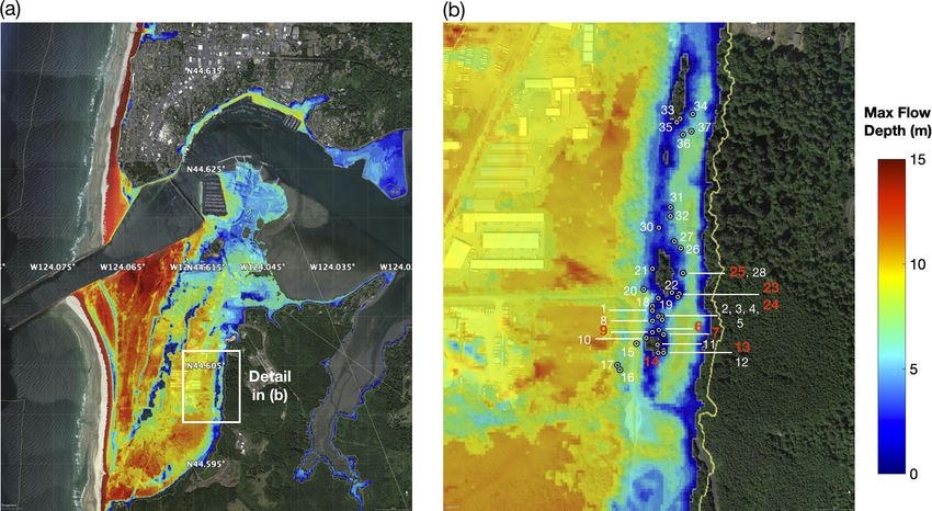
Figure 3. (a) Model of maximum tsunami inundation depth at South Beach for the L-sized earthquake 1700 CE event; (b) zoom-in view of
the tsunami inundation depth at Mike Miller State Park. Gray dotted circles show location of trees used in this study on the north side of
the stand. Red numbers are the tree locations whose growth chronologies are shown in Fig. 4a and b. White numbers shows trees that were
cored, but chronologies do not include the years before 1700 CE. Colors on map show inundation depth from the model, implying 0–10 m of
inundation depth at the Mike Miller Park Douglas-fir stand. Green areas are high ground locations that show no inundation. The yellow line
shows, for comparison, the model of maximum run-up height for the Mw = 9.2 “XXLarge” earthquake scenario (Priest et al., 2013). Base
maps made using © Google Earth 2016.
12 m on the eastern side. It is important to note that “tsunami tion on these splay faults introduce a larger coseismic sub-
water level” is a term used to describe the elevation reached sidence along the coastline and therefore represent a more
by seawater measured relative to a stated datum (MHHW extreme inundation scenario for the 1700 CE event than pre-
herein). In contrast, “inundation depth” refers to the local vious models. Based on the turbidite records reported by
water depth or height of the tsunami above the ground af- Goldfinger et al. (2011), the L and larger earthquake scenar-
ter taking into account the coseismic subsidence at a specific ios occurred four times in the past 10 000 years and thus are
location, as shown in Fig. 2c. However, there is significant referred to as a 2500-year event, although the general earth-
variation in the topography of South Beach, and several ar- quake size class and associated time interval for an L event
eas are predicted to experience a range of inundation depths is estimated to be 800 years by Witter et al. (2011).
much less than the 16 m maximum. For example, the model
shows the amount of inundation decreases eastward of the
beach, and the location of the old-growth Douglas-fir stand 4 Impacts of earthquakes and tsunami inundation on
at Mike Miller State Park in South Beach may be subjected tree growth
to a range of inundation depth from negligible to as much
as 10 m (Fig. 3b). Moreover, the South Beach stand would 4.1 Earthquake-induced ring growth disturbance
likely have been subjected to flow velocities between 2 and
Although there is evidence for only moderate levels of
10 m s−1 (Fig. 2b). These velocities are lower than most of
ground shaking in coastal Oregon and Washington follow-
the westward portions of the South Beach Peninsula because
ing the 1700 earthquake (Obermeier and Dickenson, 2000),
the stand is located on topography that can have up to 10 m
ground motion during large earthquakes has been shown
higher elevation than most of the westward terrain. Neverthe-
to cause significant forest disturbance in other earthquake-
less, it would seem these tsunami current velocities would be
prone regions. As previously mentioned, these earthquake-
high enough to cause significant damage to the South Beach
induced disturbances are caused by felling or damaging trees,
trees through the large mass and momentum of this volume
inducing local landslides, or altering the stand’s water access
of seawater that would be observable in the tree growth.
(Jacoby et al., 1997). Trees that survive these disturbances
Lastly, it is worth noting that the L earthquake tsunami
can show sudden growth suppression events due to dam-
model presented here also involves the activation of splay
age or even sudden growth acceleration events because of
faults in the overriding plate above the subduction zone. Mo-
reduced competition from nearby damaged trees. Moreover,
https://doi.org/10.5194/nhess-21-1971-2021 Nat. Hazards Earth Syst. Sci., 21, 1971–1982, 20211976 R. P. Dziak et al.: Assessing local impacts of the 700 CE Cascadia earthquake and tsunami
pulses in tree recruitment may follow a large earthquake as impact. Catastrophic tsunami inundation events along the
young trees colonize gaps left by damaged overstory individ- Sumatran and Japanese coasts showed tsunamis have a dev-
uals (Jacoby et al., 1997). astating effect on coastal forests, damaging trees and severely
Trees can respond both directly and indirectly to the eroding and altering the beach and estuary geomorphology
effects of large earthquakes. Indirect responses can oc- (e.g., Kathiresan and Rajendran, 2005; Udo et al., 2012;
cur due to coseismic environmental changes. For exam- Lopez Caceres et al., 2018). It is expected that inundation
ple, Fuller (1912) noted trees died from flooding dur- by a tsunami would cause significant ring-growth reduction
ing the 1811–1812 New Madrid earthquakes. Wallace and due to physical impact from the wave, prolonged exposure
LaMarche (1979) found that coast redwoods (Sequoia sem- to saltwater, and from tsunami debris that would also phys-
pervirens) and Douglas-firs (Pseudotsuga menziesii) tilted ically impact the tree. There are several studies demonstrat-
by the 1906 San Andreas Fault earthquake had reaction ing the impact of the inundation of large amounts of seawa-
wood, formed to right the tree, starting in 1907. Meisling ter and salts on coastal trees after a tsunami (e.g., Kubota
and Sieh (1980) reported the January 1857 Fort Tejon earth- et al., 2017; Wang et al., 2019). These studies showed trees
quake caused conifers to lose their crowns, which reduced that survived direct physical damage from the tsunami be-
ring widths that took many years to return to pre-earthquake gan to die the following summer likely due to the physiolog-
growth rates. Jacoby and Ulan (1983) showed the Septem- ical stress of saltwater immersion. Earlywood that formed in
ber 1899 Alaskan earthquake caused nearshore Sitka spruces the spring following the tsunami had higher δ 13 C values in
(Picea sitchensis) to increase growth because coseismic up- the rings formed prior to the disaster. In a field survey fol-
lift resulted in less exposure to wind, salt spray, and root- lowing the 2010 Chilean and 2011 Japanese tsunamis, Kub-
zone erosion. Finally, in consideration of direct responses ota et al. (2017) found that the soil deposits collected in the
to earthquake impacts, Jacoby et al. (1988) analyzed conifer tsunami-inundated areas are rich in water-soluble ions com-
tree-ring samples near the epicenter of the 1812 San Juan pared with the samples collected in the non-inundated areas.
Capistrano earthquake. A total of nine on-fault trees showed In the US Pacific Northwest, when the 1700 CE coseis-
drastic growth reductions in 1813, requiring decades to re- mic tree-ring growth disturbance is considered, it is largely
turn to pre-disturbance growth rates. Similarly, Sheppard and of trees killed by inundation attributed to coseismic subsi-
Jacoby (1989) showed that the 1964 Alaskan earthquake, dence (e.g., Atwater and Yamaguchi, 1991). However, Ja-
which caused ∼ 4 m of coseismic uplift, initially induced coby et al. (1997) were able to find trees that pre-dated the
growth reduction in Sitka spruces, but the trees eventually 1700 Cascadia earthquake and survived subsidence and in-
responded with wide reaction wood rings in the following undation, which is analogous to the tree-ring growth scenario
years to regain upright positions. Van Arsdale et al. (1998) we observed in South Beach, Oregon.
showed the New Madrid earthquakes of 1811–1812 caused Jacoby et al. (1997) collected cores from 33 living Sitka
inundation of bald cypress trees near Reelfoot Lake (Ten- spruce trees that were established earlier than 1700 (i.e., at
nessee) which greatly increased radial growth from 1812 least 300 years old) that stand along the western Columbia
to 1819. In contrast, the growth of bald cypress trees in River between Washington and Oregon (∼ 220 km north of
northeastern Arkansas was severely suppressed for almost South Beach). While 15 of these trees show some evidence of
50 years following the earthquakes. Wells and Yetton (2004) disturbance at 1700, 5 trees showed no disturbance, and the
studied the 1929 Buller and 1968 Inangahua earthquakes in remaining 14 could be in either category. There were both un-
New Zealand, finding clear impacts on tree growth, where usual decreases and increases in ring width in disturbed trees.
swamps on elevated terraces are generally best for preserving Disturbed trees also showed waterlogging and increasing
earthquake records because they are not affected by drought numbers of traumatic resin canals at 1700 (sap-conducting
or wind. As for tree growth disturbances due to earthquake tubes formed by altered cells), but only two formed reaction
shaking, Fu et al. (2020) showed how the 1950 Zayu-Medog wood in response to coseismic tilting or flooding. Growth re-
magnitude 8.6 earthquake in the southeastern Tibetan Plateau sponses occurred over a range of years with clear declines
influenced tree growth during the period 1950–1955. How- occurring as early as 1698 and as late as 1702 to 1706.
ever, alpine trees were less disturbed than those located at Thus, the exact timing of tree-ring disturbances due to
middle and low elevations. Severe growth suppressions oc- an earthquake and the resulting ground motion, coastal land
curred during the first 3 years after the earthquake and were subsidence, and tsunami inundation can vary within a few
stronger at low elevations. years around the event date. This is because tree growth can
be affected by many climatological or meteorological fac-
4.2 Tsunami-induced tree-ring growth disturbance tors, including droughts, cold/heat stress, fires, windstorms,
and even insect infestations. However, comparison of coastal
Just as trees located near epicenters of large earthquakes can growth rings with other regional sites can be used to control
be disturbed and experience growth changes from intense for these climate and/or weather disturbance impacts. Thus,
shaking and ground displacement, inundation of a coastal despite this temporal variability, Jacoby et al. (1997) con-
forest by a large tsunami should also have a significant clude that the subduction earthquake and subsidence event
Nat. Hazards Earth Syst. Sci., 21, 1971–1982, 2021 https://doi.org/10.5194/nhess-21-1971-2021R. P. Dziak et al.: Assessing local impacts of the 700 CE Cascadia earthquake and tsunami 1977
occurred between the growing seasons of 1699 and 1700.
Therefore it seems likely a combination of the effects from
earthquake ground motion, coastal land subsidence, and
rapid inundation by several meters of fast-moving seawater
can be observed in the variation of ring growth chronologies
from trees within the impact zone.
5 Tree-ring growth chronologies from South Beach,
Oregon
In an attempt to further quantify the widespread effects of
the 1700 CE earthquake, we obtained tree-ring records from
a stand of old-growth Douglas-fir trees (Pseudotsuga men-
ziesii) that pre-date 1700 (Fig. 4a and b). The stand is located
in an Oregon State Park in South Beach, Oregon, roughly
600 m east of Highway 101 (Fig. 3a and b). Old growth trees
of 300+ years of age are rare along the Oregon coast; thus
this stand of trees within the inundation zone presented a
unique opportunity to search for direct physical evidence of
the impact of a Cascadia Subduction Zone earthquake and
tsunami inundation in a populated area where tsunami mod-
els indicate significant inundation levels and run-up heights.
To ground truth the model of the 1700 CE tsunami, we col-
lected tree cores at breast height from 37 dominant or codom-
inant old-growth trees at the South Beach site using a 0.8 m
increment borer. One to two cores were collected from each
tree, after which cores were mounted, sanded with increas-
ingly fine lapping film, and cross-dated (Phipps, 1985). Each
core was then measured using a Velmex TA tree-ring mea-
suring device to the nearest 0.001 mm (Velmex, Inc. Bloom-
field, NY). Cross dating was then statistically verified using
the program COFECHA, which is designed to find errors
in chronologies (Holmes, 1983). A master growth-increment
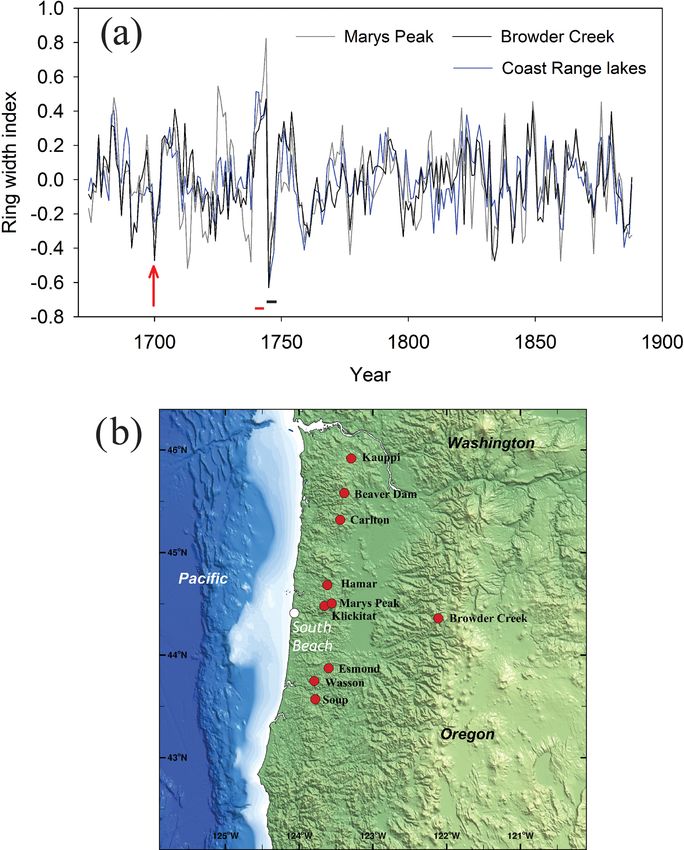
chronology was then developed by detrending each mea- Figure 4. (a) Tree-ring growth records of old-growth Douglas-fir
surement time series using negative exponential or regres- trees (Pseudotsuga menziesii) located in Mike Miller State Park,
sion functions to retain as much low-frequency variability South Beach, Oregon (see Fig. 1). The vertical axis shows ring
as possible, as well as a second chronology developed us- growth (in cm), and the time range covers several decades before
and after 1700 CE. The color of each growth record relates to alpha-
ing a 50-year 50 % frequency-cutoff cubic spline to highlight
numeric labels of individual trees shown in the legend, with the lo-
interdecadal to interannual growth variability. All chronol- cation of trees shown in Fig. 3b. The designation “A/B” represents
ogy construction was performed using the program AR- two cores from the same tree. The black arrow marks the 1700 CE
STAN, a tree-ring standardization program based on detrend- date, and red arrows highlight the 1691, 1738, and 1745 CE large
ing and autoregressive time series modeling (Cook and Kru- growth reductions that may have been caused by significant clima-
sic, 2005). Figure 3a and b show the location of the Douglas- tological events. Panel (b) shows detailed growth record of trees in
fir trees sampled for this study in relation to the modeled (a) 4 years before and after 1700.
tsunami run-up heights for South Beach. Of all the trees sam-
pled, a total of 12 cores from 8 trees pre-dated 1700 (Fig. 4b).
As noted, the tsunami inundation model presented here in this area may have experienced as much as ∼ 10 m of inun-
(Fig. 2a and b) indicates the L earthquake would produce a dation depth, several trees are also on high ground and may
tsunami that could inundate the lowlands of South Beach to have experienced much less, or even zero, inundation.
inundation depths up to 18 m. However, the Douglas-fir old- Tree-ring data detrended using negative exponential func-
growth stand that is the subject of this study lies on and along tions did not reveal major stand-wide releases or suppres-
the western edge of two parallel north–south striking topo- sions around 1700 (data not shown) nor did data detrended
graphic highs (likely paleo-dune ridge lines). The tsunami using the 50-year spline functions. Detailed examination of
model presented here indicates that while many of the trees the growth-ring samples indicates that although individual
https://doi.org/10.5194/nhess-21-1971-2021 Nat. Hazards Earth Syst. Sci., 21, 1971–1982, 20211978 R. P. Dziak et al.: Assessing local impacts of the 700 CE Cascadia earthquake and tsunami
cores have below-average growth, and one experiences what 6 Discussion
could be interpreted as a post-1700 growth release, variabil-
ity around 1700 is not necessarily exceptional in the longer- Analysis of tree-ring data presented here indicates there is a
term context of the ∼ 310-year history of the dataset (Fig. 4a reduction in Douglas-fir tree growth at a site associated with
and b). Indeed, there are several other growth reductions in the 1700 Cascadia Subduction Zone earthquake and tsunami
the record that are the same magnitude or larger than the in South Beach, Oregon, relative to other inland sites in the
disturbance at 1700 CE. Most notably, there are large sup- Oregon Coast Range. The growth reduction is not outside
pressions observed beginning around 1691 and again in 1739 the range of variability, as illustrated by other much more se-
and 1745 (arrows on Fig. 4a). The 1739 reduction has been vere reductions over the 310-year South Beach chronology
observed in other old-growth stand chronologies throughout (Fig. 5a and b). However, there is at least a subtle growth re-
Cascadia and may be due to a significant climatological event duction that deviates from other nearby locations. Although
such as a drought (Carroll and Jules, 2005; Carroll et al., beyond the scope of this study, further chemical analysis is
2014). needed to show that the tree rings collected at South Beach
exhibit higher δ 13 C or water-soluble ion levels to establish
5.1 Control sites in western Oregon Cascades and that the trees here were immersed in seawater.
Coast Range The tsunami inundation model presented here, which as-
sumes the L- or large-sized earthquake (Mw = 9.0) for the
To better detect unusual growth anomalies around 1700, we 1700 event (Wei, 2017), shows the resulting tsunami would
compared the South Beach Douglas-fir tree-ring data to two have inundated the South Beach Douglas-fir stand. The
other Douglas-fir datasets from the Oregon Coast Range and growth reduction in Douglas-fir at South Beach is less pro-
one from the western Cascade Mountains, all of which would nounced than those observed following the 2011 Japanese
have experienced similar climate conditions but not tsunami tsunami or the post-1700 growth suppressions observed by
inundation. The first of these was an old-growth stand on Jacoby et al. (1997) along the Columbia River ∼ 220 km to
Marys Peak (∼ 46 km east of South Beach) in the central the north of our study site. While modest, spanning no more
coast range. The second is Browder Creek located ∼ 160 km than 2 years relative to the control sites, and not absolute con-
east in the western Cascade Mountains (Black et al., 2015; clusive evidence, the growth reduction is at least consistent
Fig. 5a and b). The third was a chronology generated from with such an event and with both the magnitude and multi-
samples of dead trees in lakes in the western and central year time period of growth reductions observed by Jacoby et
Oregon Coast Range. These lakes had formed when land- al. (1997) along the Columbia River ∼ 220 km to the north.
slides impounded streams, and the preserved drowned trees Speculatively, the observed growth reductions could pos-
were then used to establish the date of lake formation, and sibly represent multiple large earthquakes (magnitude 8+)
thus the landslide event (Struble et al., 2020). Eight lakes over that time period rather than one great magnitude 9 earth-
had a combined number of 15 trees (and 31 sets of mea- quake at 1700. Although we cannot rule out multiple earth-
surements) that pre-dated 1700 and were used to generate quakes using our tree-ring growth data, the record of the or-
a “control” chronology. As with Mike Miller trees, all mea- phan tsunami in Japan is evidence that only one large earth-
surement time series in the control datasets were detrended quake occurred. Moreover, the tsunami inundation model
with 50-year splines. The Oregon Coast Range sites range presented here would not necessarily need to change in the
in elevation from 137 m (Hamar Lake) to 380 m (Klickitat multiple earthquake scenario since zero inundation at the old
Lake), with the exception of Marys Peak, which is 900 m. growth stand in South Beach is one possible model result.
The lone western Cascade site, Browder Creek, is 1108 m. Although tree rings and various geologic lines of evidence
All sites are at low enough elevation that they are most lim- have been useful in establishing the date of the last Cas-
ited by summer (July–September) drought as opposed to cadia earthquake, there is still some question as to the de-
higher-elevation sites that are most sensitive to temperature. gree of peak ground motion associated with the event. As
Relationships with drought are somewhat stronger at Marys previously discussed, a coastal-wide inventory of liquefac-
Peak and Browder Creek, but this is likely due to their more tion features associated with the 1700 CSZ event indicate
inland locations. only moderate levels of ground shaking in coastal Oregon
When compared to the control sites, South Beach tree and Washington (Obermeier and Dickenson, 2000). Multi-
growth is significantly lower than the lakes, Marys Peak, or ple, smaller magnitude megathrust earthquakes before, dur-
Browder Creek in 1700 (t test of p < 0.001) after detrend- ing, and after 1700 would be one possible explanation for
ing all series with the 50-year 50% frequency-cutoff cubic a lower than expected peak ground motion and fewer ob-
splines. Moreover, the lake trees and Marys Peak trees do not served liquefaction features throughout the region. Mapping
significantly differ in growth in 1700, suggesting the South seismically induced landslides in the Oregon Coast Range
Beach Douglas-fir growth is unusually low across sites with is potentially another means to assess levels and distribution
the most similar climatic histories and sensitivities. of seismic shaking impacts from the 1700 CSZ event, given
large-magnitude earthquakes in mountainous regions around
Nat. Hazards Earth Syst. Sci., 21, 1971–1982, 2021 https://doi.org/10.5194/nhess-21-1971-2021R. P. Dziak et al.: Assessing local impacts of the 700 CE Cascadia earthquake and tsunami 1979 Figure 5. (a) Difference in growth chronologies between Mike Miller and reference sites at Marys Peak, Browder Creek, and Oregon Coast Range lake sites. The 1700 CE chronology indicated by the red arrow, and the significant growth differences between coast and inland sites in 1739–1741 and 1745–1748 are highlighted by red and black lines, respectively. Panel (b) shows location map with Marys Peak and lake sites relative to South Beach. The number of cores available at each site during the 1700 time period are South Beach (14), Marys Peak (28), Oregon Coast Range lakes (31), and Browder Creek (30). The Oregon Coast Range lakes include Beaver Dam Lake, Carlton Lake, Esmond Lake, Hamar Lake, Kauppi Lake, Klickitat Lake, Soup Lake, and Wasson Lake. Map created using digital elevation data points complied by the National Center for Environmental Information (http://ncei.noaa.gov, last access: September 2020). the world typically trigger thousands of landslides, and slope al., 2018; LaHusen et al., 2020; Struble et al., 2020). Thus failures constitute a significant proportion of the damage as- a continued search for physical evidence of tsunami inunda- sociated with these events (Stuble et al., 2020). Recent stud- tion, earthquake shaking, and coseismic landslides is needed ies have demonstrated the utility of dendrochronology to date to refine expectations of the inundation, as well as intensity the ages of landslides in these settings (Stuble et al., 2020). and distribution of ground shaking during future Cascadia However, despite the Oregon Coast Range exhibiting thou- megathrust earthquakes. sands of landslides, none have been conclusively associated with the 1700 subduction earthquake, and despite proximity to the megathrust rupture, most deep-seated landslides in the Oregon Coast Range were triggered by rainfall (Perkins et https://doi.org/10.5194/nhess-21-1971-2021 Nat. Hazards Earth Syst. Sci., 21, 1971–1982, 2021
1980                              R. P. Dziak et al.: Assessing local impacts of the 700 CE Cascadia earthquake and tsunami

7   Conclusion                                                          Competing interests. The authors declare that they have no conflict
                                                                        of interest.
We presented a series of tree-ring data from an old-growth
Douglas-fir forest in South Beach, Oregon, that show sig-
nificant growth reduction at the time of the 1700 CE Casca-             Disclaimer. Publisher’s note: Copernicus Publications remains
dia Subduction Zone earthquake relative to control sites. In            neutral with regard to jurisdictional claims in published maps and
addition, we presented a new, high-resolution model of the              institutional affiliations.
1700 tsunami inundation at the South Beach old-growth site.
Due to significant variation in the South Beach topography,
several areas are predicted to experience water levels up to            Acknowledgements. The authors wish to thank the editor and three
17 m and a range of inundation depths up to 16 m; however,              reviewers. We also thank Joseph Haxel, Mathew Fowler, and
                                                                        Nuno Simao for helping collect tree cores. The research in this
the location of the old-growth stand may be subjected to a
                                                                        paper was sponsored by the NOAA/Pacific Marine Environmental
range of inundation depths from 0 to 10 m. To better detect
                                                                        Laboratory, PMEL paper contribution number 5184. Yong Wei’s
tree growth anomalies near 1700 CE, we also compared the                work is funded by the Joint Institute for the Study of the At-
South Beach Douglas-fir tree-ring data to two other Douglas-            mosphere and Ocean (JISAO) under NOAA Cooperative Agree-
fir datasets from the Oregon Coast Range and western Cas-               ment NA15OAR4320063, contribution no. 2020-1084. All data are
cade Mountains which would have experienced similar cli-                available from the authors upon request, without undue reservation,
mate conditions but not tsunami inundation. When compared               to any qualified researcher.
to these control sites, South Beach tree growth is significantly
lower in 1700 CE, which reaffirms that the South Beach
Douglas-fir growth is unusually low for the region. Thus the            Financial support. This project was supported by the National
timing of the observed growth reductions in the South Beach             Oceanic and Atmospheric Administration’s Pacific Marine Environ-
Douglas-fir stand is consistent with these disturbances being           mental Laboratory.
associated with the 1700 CE Cascadia megathrust earthquake
and the resulting tsunami, subsidence, and ground motion.
Overall, we think our study further supports the view that              Review statement. This paper was edited by Maria Ana Baptista
                                                                        and reviewed by Jean Roger and two anonymous referees.
tree-ring data are a promising tool for providing insights on
the spatial distribution of coseismic impacts from megathrust
earthquakes, as well as potential ground-truth information for
tsunami inundation models.
                                                                        References

                                                                        Atwater, B., Satoko, M. R., Satake, K., Yoshinobu, T., Kazue, U.,
Code availability. The MOST model was created by Vasily Titov             and Yamaguchi, D. K.: The orphan tsunami of 1700-Japanese
(Titov and Synolakis, 1995, 1998). The MOST codes used in the             clues t a parent earthquake in the North America, US Geol. Sur-
present study have been re-written utilizing the graphics process-        vey Professional Paper 1707, US Geological Survey, Reston, Vir-
ing unit (GPU) technology to boost the computational speed. The           ginia, USA, p. 14, 2006.
Boussinesq model codes were created by Hongqiang Zhou (Zhou             Atwater, B. F.: Geologic evidence for earthquakes during the past
and Teng, 2010), previously a research scientist at the University of     2000 years along the Copalis River, southern coastal Washington,
Washington and now a data scientist at TISTA Science and Tech-            J. Geophys. Res., 97, 1901–1919, 1992.
nology Corporation.                                                     Atwater, B. F. and Yamaguchi, D. K.: Sudden, probably coseismic
                                                                          submergence of Holocene trees and grass in coastal Washington
                                                                          State, Geology, 19, 706–709, 1991.
Sample availability. The Mike Miller, Cape Perpetua, and Marys          Atwater, B. F., Tuttle, M. P., Schweig, E. S., Rubin, E. S., Yam-
Peak tree-ring data were added to the NOAA National Centers               aguchi, D. K., and Hemphill-Haley, E.: Earthquake recurrence
for Environmental Information International Tree-Ring Databank,           inferred from paleoseismology, Dev. Quatern. Sci., 1, 331–350,
https://www.ncdc.noaa.gov/data-access/paleoclimatology-data/              2003.
datasets/tree-ring (last access: January 2021) (NOAA, 2021).            Black, B. A., Dunham, J. B., Blundon, B. W., Brim-Box, J., and
                                                                          Tepley, A. J.: Long-term growth-increment chronologies reveal
                                                                          diverse influences of climate forcing on freshwater and forest
Author contributions. RPD prepared the manuscript with contribu-          biota in the Pacific Northwest, Global Change Biol., 21, 594–
tions from all co-authors. BAB and RPD collected the tree-ring            604, 2015.
samples, performed growth disturbance analysis, and wrote the           Buchwal, A., Szczucinski, W., Strzelecki, M., and Long, A. J.: New
manuscript. YW developed the tsunami model code, performed                insights into the 21 November 2000 tsunami in West Greenland
the simulations, and wrote the tsunami section of the manuscript.         from analyses of the tree-ring structure of Salix glauca, Polish
SGM drafted initial maps used in the manuscript.                          Polar Res., 36, 51–65, 2015.
                                                                        Carroll, A. L. and Jules, E. S.: Climatic assessment of a 580-
                                                                          year Chamaecyparis Lawsoniana (Port Orford cedar) tree-ring

Nat. Hazards Earth Syst. Sci., 21, 1971–1982, 2021                                      https://doi.org/10.5194/nhess-21-1971-2021
R. P. Dziak et al.: Assessing local impacts of the 700 CE Cascadia earthquake and tsunami 1981
chronology in the Siskiyou mountains, USA, Madrono, 52, 114– Nelson, A. R., Atwater, B. F., Bobrowsky, P. T., Bradley, L. A.,
122, 2005. Clague, J. J., Carver, G. A., Darienzo, M. K., Grant, W. C.,
Carroll, A. L., Sillett, S. C., and Kramer, R. D.: Millennium- Kruger, H. W., Sparks, R., Stafford, T. W., and Stuiver, M.: Ra-
Scale Crossdating and Inter-Annual Climate Sensitivities of diocarbon evidence for extensive plate-boundary rupture about
Standing California Redwoods, PLOS One, 9, e102545, 300 years ago at the Cascadia subduction zone, Nature, 378, 371–
https://doi.org/10.1371/journal.pone.0102545, 2014. 374, 1995.
Chow, V. T.: Open-Channel Hydraulics, McGraw-Hill Book Com- NOAA: Tree Ring, available at: https://www.ncdc.noaa.gov/
pany, New York, p. 113, 1959. data-access/paleoclimatology-data/datasets/tree-ring, last ac-
Cook, E. R. and Krusic, P. J.: ARSTAN v. 41d: A tree-ring standard- cess: January 2021.
ization program based on detrending and autoregressive time se- Obermeier, S. F. and Dickenson, S. E.: Liquefaction evidence for
ries modeling, with interactive graphics, Tree-Ring Laboratory, the strength of ground motion resulting from Late Holocene Cas-
Lamont-Doherty Earth Observatory of Columbia University, Pal- cadia Subduction earthquakes, with emphasis on the event of
isades, New York, USA, 2005. 1700 AD, Bull. Seismol. Soc. Am., 90, 876–896, 2000.
Fu, T., Liang, E., Lu, X., Gao, S., Zhang, L., Zhu, H., Perkins, J. P., Roering, J. J., Burns, W. J., Struble, W., Black, B.
Rossi, S., and Camarero, J.: Tree growth responses and A., Schmidt, K. M., Duvall, A., and Calhoun, N.: Hunting for
resilience after the 1950-Zayu-Medog earthquake, south- landslides from Cascadia’s great earthquakes, Eos Am. Geophys.
east Tibetan Plateau, Dendrochronologia, 62, I25724, Un., 9 pp., 8 August 2018.
https://doi.org/10.1016/j.dendro.2020.125724, 2020. Phipps, R. L.: Collecting, preparing, crossdating, and measuring in-
Fuller, M. L.: The New Madrid earthquake, US Geological Sur- crement cores, US Geological Survey Water-Resources Investi-
vey Bulletin 494, US Geological Survey, Reston, Virginia, USA, gations Report 85-4148, US Geological Surve, Reston, Virginia,
119 pp., 1912. USA, 1–47, 1985.
Goldfinger, C.: Submarine paleoseismology based on turbidite Priest, G. R., Witter, R. C., Zhang, Y. J., and Wang, K.: Tsunami in-
records, Annu. Rev. Mar. Sci., 3, 35–66, 2011. undation scenarios for Oregon, Open-file Report 0-13-19, State
Goldfinger, C., Nelson, C. H., and Johnson, J. E.: Holocene of Oregon Department of Geology and Mineral Industries, Port-
earthquake records from the Cascadia Subduction Zone and land, Oregon, USA, 14 pp., 2013.
northern San Andreas Fault based on precise dating of off- Satake, K., Shimazaki, K., Shuji, Y., and Ueda, K.: Time and size
shore turbidites, Annu. Rev. Earth Planet. Sci., 31, 555–577, of a giant earthquake in Cascadia inferred from Japanese tsunami
https://doi.org/10.1146/annurev.earth.31.100901.141246, 2003. records of January 1700, Nature, 379, 246–249, 1996.
Holmes, R. L.: Computer-assisted quality control in tree-ring dating Satake, K., Wang, K., and Atwater, B. F.: Fault slip and seis-
and measurement, Tree-Ring Bull., 43, 69–78, 1983. mic moment of the 1700 Cascadia earthquake inferred from
Jacoby, G. C. and Ulan, L. D.: Tree ring indications of uplift at Icy Japanese tsunami descriptions, J. Geophys. Res., 108, 2535,
Cape, Alaska, related to 1899 earthquakes, J. Geophys. Res., 88, https://doi.org/10.1029/2003JB002521, 2003.
9305–9313, https://doi.org/10.1029/JB088iB11p09305, 1983. Sheppard, P. R. and Jacoby, G. C.: Application of tree-ring analy-
Jacoby, G. C., Shepphard, P. R., and Sieh, K. E.: Irregular recurrence sis to paleoseismology: Two case studies, Geology, 17, 226–229,
of large earthquakes along the San Andreas Fault: Evidence from 1989.
Trees, Science, 241, 196–199, 1988. Struble, W. T., Roering, J. J., Black, B. A., Burns, W. J., Cal-
Jacoby, G. C., Bunker, D. E., and Benson, B. E.: Tree-ring evidence houn, N., and Wetherell, L.: Dendrochronological dating of land-
for an A.D. 1700 Cascadia earthquake in Washington and north- slides in western Oregon: Searching for signals of the Cascadia
ern Oregon, Geology, 25, 999–1002, 1997. A.D. 1700 earthquake, Geol. Soc. Am. Bull., 132, 1775–1791,
Kathiresan, K. and Rajendran, N.: Coastal mangrove forest miti- https://doi.org/10.1130/B35269.1, 2020.
gated tsunami, Estuar. Coast. Shelf Sci., 65, 601–606, 2005. Tang, L., Titov, V. V., and Chamberlin, C. D.: Development, test-
Kubota, T., Kagawa, A., and Kodama, N.: Effects of salt water im- ing, and applications of site-specific tsunami inundation mod-
mersion caused by a tsunami on 13 C and 18 O values of Pinus els for real-time forecasting, J. Geophys. Res., 114, C12025,
thunbergii tree-ring cellulose, Ecol. Res., 32, 271–277, 2017. https://doi.org/10.1029/2009JC005476, 2009.
LaHusen, S. R., Duvall, A. R., Booth, A. M., Grant, A., Mishkin, Titov, V. V. and Gonzalez, F. I.: Implementation and testing of
B. A., Montgomery, D. R., Struble, W., Roering, J. J., and Wart- the method of splitting tsunami (MOST) model, NOAA Techni-
man, J.: Rainfall triggers more deep-seated landslides than Cas- cal Memorandum ERL PMEL-112, NOAA, Silver Spring, MD,
cadia earthquakes in the Oregon Coast Range, USA, Sci. Adv., USA, 11 pp., 1997.
6, eaba6790, https://doi.org/10.1126/sciadv.aba6790, 2020. Titov, V. V. and Synolakis, C. E.: Modeling of breaking and nonbre-
Lopez Caceres, M. L., Kakano, S., Ferrio, J. P., Hayashi, M., Nakat- aling long-wave evolution and runup using VTCS-2, J. Waterw.
suka, T., Yamanaka, T., and Nobori, Y.: Evaluation of the ef- Port Coast. Ocean Eng., 121, 308–316, 1995.
fect of the 2011 tsunami on coastal forests by means of multi- Titov, V. V. and Synolakis, C. E.: Numerical modeling of tidal wave
ple isotopic analyses of tree-rings, Isotop. Environ. Health Stud., runup, J. Waterw. Port Coast. Ocean Eng., 124, 157–171, 1998.
54, 494–507, https://doi.org/10.1080/10256016.2018.1495203, Titov, V. V., Kânoğlu, U., and Synolakis, C.: Development of MOST
2018. for real-time tsunami forecasting, J. Waterw. Port Coast. Ocean
Meisling, K. E. and Sieh, K. E.: Disturbance of trees by the Eng., 142, 03116004, https://doi.org/10.1061/(ASCE)WW.1943-
1857 Fort Tejon earthquake, CA, J. Geophys. Res., 85, 3225– 5460.0000357, 2016.
3238, 1980. Udo, K., Sugawara, D., Tanaka, H., Imai, K., and Mano, A.: Impact
of the 2011 Tohoku earthquake and tsunami on beach morphol-
https://doi.org/10.5194/nhess-21-1971-2021 Nat. Hazards Earth Syst. Sci., 21, 1971–1982, 20211982 R. P. Dziak et al.: Assessing local impacts of the 700 CE Cascadia earthquake and tsunami
ogy along the northern Sendai coast, Coast. Eng. J., 54, 1250009, Wei, Y., Chamberlin, C., Titov, V. V., Tang, L., and Bernard,
https://doi.org/10.1142/s057856341250009x, 2012. E. N.: Modeling of the 2011 Japan tsunami – Lessons for
Van Arsdale, R. B., Stahle, D. W., Cleaveland, M. K., and near-field forecast, Pure Appl. Geophys., 170, 1309–1331,
Guccione, M. J.: Earthquake signals in tree-ring data from https://doi.org/10.1007/s00024-012-0519-z, 2013.
the New Madrid seismic zone and implications for paleo- Wells, A. and Yetton, M.: Earthquake and tree-ring impacts in
seismicity, Geology, 26, 515–518, https://doi.org/10.1130/0091- the middle and upper Buller River catchment, Earthquake Com-
7613(1998)0262.3.CO;2, 1998. mission Research Report No. 03/492, Earthquake Commission,
Wallace, R. E. and LaMarche, V. C.: Trees as indicators of past Christchurch, New Zealand, 65 pp., 2004.
movements on the San Andreas Fault, Earthq. Inform. Bull., 2, Witter, R. C., Zhang, Y., Wang, K., Priest, G. R., Goldfinger, C.,
127–131, 1979. Stimely, L. L., English, J. T., and Ferro, P. A.: Simulating tsunami
Wang, W., McDonald, N. G., Ward, N. D., Indivero, J., Gunn, inundation at Bandon, Coos County, Oregon, using hypotheti-
C., and Bailey, V. L.: Constrained tree growth and gas ex- cal Cascadia and Alaska earthquake scenarios, Special Paper 43,
change of seawater exposed forests in the Pacific Northwest, State of Oregon Department of Geology and Mineral Industries,
U.S.A., J. Ecol., 107, 2541–2552, https://doi.org/10.1111/1365- Portland, Oregon, USA, 57 pp., 2011.
2745.13225, 2019. Yamaguchi, D. K., Atwater, B. F., Bunker, D. E., Benson, B. E.,
WDNR: Modeling a magnitude 9.0 earthquake on the Cascadia and Reid, M. S.: Tree-ring dating the 1700 Cascadia earthquake,
Subduction Zone off the Pacific Coast, available at: http://www. Nature, 389, 922–923, https://doi.org/10.1038/40048, 1997.
dnr.wa.gov/Publications/ger_seismic_scenario_cascadia.pdf Yeats, R. S.: Living with earthquakes in the Pacific Northwest, a sur-
(last access: September 2020), 2012. vivor’s guide, second edition: Corvallis, Oregon State University
Wei, Y.: Tsunami inundation modeling for the OSU Marine Stud- Press, Corvallis, Oregon, USA, p. 400, 2004.
ies Initiative Building, report, YGH Architecture, Oregon State Zhou, H. and Teng, M. H.: Extended fourth-order depth-integrated
University, Corvallis, Oregon, USA, p. 39, November 2017. model for water waves and currents generated by submarine
Wei, Y., Bernard, E., Tang, L., Weiss, R., Titov, V. V., Moore, landslides, J. Eng. Mech., 136, 506–516, 2010.
C., Spillane, M., Hopkins, M., and Kânoğlu, U.: Real- Zhou, H., Moore, C. W., Wei, Y., and Titov, V. V.: A nested-
time experimental forecast of the Peruvian tsunami of Au- grid Boussinesq-type approach to modelling dispersive propa-
gust 2007 for U.S. coastlines, Geophys. Res. Lett., 35, L04609, gation and runup of landslide-generated tsunamis, Nat. Hazards
https://doi.org/10.1029/2007GL032250, 2008. Earth Syst. Sci., 11, 2677–2697, https://doi.org/10.5194/nhess-
11-2677-2011, 2011.
Nat. Hazards Earth Syst. Sci., 21, 1971–1982, 2021 https://doi.org/10.5194/nhess-21-1971-2021You can also read