INVESTIGATION OF METHODS FOR SATELLITE INSPECTION - OF POWER LINES AND FOREST VOLUME - DIVA PORTAL
←
→
Page content transcription
If your browser does not render page correctly, please read the page content below

EXAMENSARBETE INOM TEKNIK,
GRUNDNIVÅ, 15 HP
STOCKHOLM, SVERIGE 2020

Investigation of Methods for
Satellite Inspection
of Power Lines and Forest Volume

LINNEA BERGMARK, WILLIAM WALLSTEDT

KTH
SKOLAN FÖR ARKITEKTUR OCH SAMHÄLLSBYGGNAD
Acknowledgements
Firstly, we want to thank our supervisor and teacher, Doctor Takeshi Shirabe, for guiding us
from the start to the end of this thesis. We want to thank Sergiu Iliev and Arshak Ulubabyan
at Spacept for providing valuable insights in their work, supporting us with great commitment
and patience, and taking the time to have online meetings with us as often as every week.
André Wästlund at SCA Skog has been a great contributor and has ambitiously and in great
detail answered all questions and ideas that we have sent him. André Wästlund also made
us the favour to introduce us to Associate Professor Henrik Persson. Henrik Persson has
great knowledge within remote sensing of forest as well as the forest industry itself and he
has been very open in supporting our work, which we are grateful for.

                                              1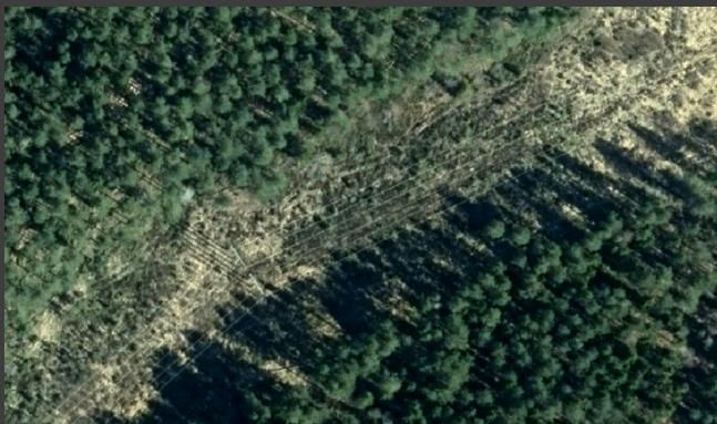
Sammanfattning
Att underhålla infrastruktur med hög standard är viktigt för alla länder, och att misslyckas
med detta innebär allvarliga logistiska och ekonomiska konsekvenser.
Kraftledningsinspektion är en betydelsefull del i detta. Denna uppsats har sökt svar på vad
för- och nackdelarna är med att använda satellitövervakning av kraftledningar, samt svar på
ifall teknik för satellitövervakning av kraftledningar också kan tillämpas på volymberäkningar
av skog. Metoden har utgått från intervjuer med experter och relevanta företag samt litteratur
som underlag.

Att undersöka vilka för- och nackdelar som finns med satellitövervakning av kraftledningar
var viktigt eftersom satellitövervakning är ett snabbt växande fält, men inte särskilt väl
undersökt. Att undersöka huruvida teknik för kraftledningsövervakning med satelliter är
tillräcklig för att estimera skogsvolym bedömdes vara värdefullt eftersom skogsvolym idag
estimeras med luftburen LiDAR, medan luftburen LiDAR påstods vara signifikant mycket
dyrare överlag än satellitmätningar. Det fanns alltså en eventuell ekonomisk fördel med att
estimera skogsvolym med satelliter istället för dagens luftburna mätningar. Det förväntade
resultatet var att tekniken för satellitövervakning av kraftledningar är tillräcklig för att estimera
skogsvolym.

De största nackdelarna med satellitövervakning av kraftledningar berör problemen med att
nå tillräckligt hög noggrannhet i processerna för trädidentifiering, samt att utveckla effektiva
tillvägagångssätt för att utvärdera detta då underlaget gällande föreslagna och utvärderade
metoder är glest. En annan nackdel visade sig vara att satellitmetoderna är svåra att göra
konkurrenskraftiga i jämförelse med de etablerade luftburna LiDAR-metoderna i fråga om
kostnader. Anledningen är att de högupplösta satellitbilder som ofta krävts för att nå hög
noggrannhet fortfarande är dyra, även om en fördel som också identifierades var att ny och
billigare satellitteknik just nu utvecklas i hög takt. Gällande denna fråga visade sig den
största fördelen vara den snabba utvecklingen av nya satelliter med högre upplösning, som
öppnar upp möjligheten för att komma ikapp de konventionella metoderna.

Det förväntade resultatet kring huruvida satellitövervakning har ekonomiska fördelar jämfört
med luftburen övervakning motsägs alltså av resultatet i denna rapport, med avseende på
kraftledningsövervakning. Däremot indikerar resultatet att tekniken för satellitövervakning av
kraftledningar är tillräcklig för att estimera skogsvolym, vilket överensstämmer med det
förväntade resultatet.

Abstract
Maintaining infrastructure of high standard is important for all countries. Failing this means
severe logistical and economic consequences. Power line inspection is an important part of
this. This thesis has searched for an answer to what the advantages and disadvantages are
of inspecting power lines by using satellites, as well as an answer to if the technology of
satellite surveillance of power lines is sufficient to estimate forest volume. The methodology
of the thesis has been to turn to companies and experts in the field and to use relevant
literature.

Examining what the advantages and disadvantages of satellite inspection of power lines are
was important since satellite surveillance is a growing field, but not very well researched. To
analyze whether technology of satellite surveillance of power lines is enough to estimate
forest volume was thought to be valuable since forest volume today is estimated by airborne
LiDAR, while airborne LiDAR was claimed to be significantly more expensive in general than

                                                  2
satellite measurements. Thus, there was a potential economic advantage to estimate forest
volume with satellites instead of airborne measurements. The expected result was that the
technology of satellite surveillance of power lines is sufficient to estimate forest volume.

The biggest disadvantages of satellite surveillance of power lines involve the problems of
achieving high enough accuracy in the processes of tree identification, as well as developing
effective formulas to evaluate this when the research material of proposed methods is
sparse. Another disadvantage turned out to be that the satellite methods are hard to compete
with, in comparison to the established airborne LiDAR methods and in regard to cost. The
reason is that the high-resolution satellite images that often are demanded still are
expensive, even though an advantage that also was identified in this thesis is that new and
cheaper satellite technology is being developed at a quick rate. The biggest advantage of
satellite surveillance of power lines turned out to be the quick development of new satellites
with higher resolution, which enables the possibility to catch up with the conventional
methods.

The expected result in regard to whether satellite surveillance has economic advantages
compared to airborne surveillance is contradicted in the result of this thesis, in regard to
power line inspection. However, the result indicates that the technology of satellite
surveillance of power lines is sufficient to estimate forest volume, which concurs with the
expected result.

                                               3
Abbreviations
NDVI
Normalized Difference Vegetation Index.
DEM
Digital Elevation Model.
DSM
Digital Surface Model.
DTM
Digital Terrain Model.
LiDAR
Light Detection and Ranging.
ALS
Airborne Laser Scanning.
SAR
Synthetic Aperture Radar.
CHM
Canopy Height Model.
RMSE
Root Mean Square Error
UAV
Unmanned Aerial Vehicle.
4Table of content
Acknowledgements ................................................................................................................1
Sammanfattning .....................................................................................................................2
Abstract ..................................................................................................................................2
Abbreviations .........................................................................................................................4
1. Introduction.........................................................................................................................6
1.1 Background...................................................................................................................6
1.1.1 The Swedish forest industry ...................................................................................6
1.1.2 Power line inspection ..............................................................................................6
1.1.3 Satellite methods ....................................................................................................8
1.2 Objectives .....................................................................................................................8
1.3 Demarcation of - and motivation behind the objectives .................................................8
1.3.1 Power line corridors ................................................................................................8
1.3.2 Forest volume estimation........................................................................................9
1.4 Expected results .........................................................................................................10
1.4.1 Advantages and disadvantages of satellite methods for power line inspections....10
1.4.2 Applying satellite surveillance of power lines to estimate forest volume ................10
1.5 Literature review .........................................................................................................11
1.5.1 Vegetation monitoring ...........................................................................................11
1.5.2 Remote sensing for power line corridors ...............................................................12
1.5.3 Satellite vegetation monitoring for power line corridors .........................................12
2. Methodology .....................................................................................................................14
3. Results .............................................................................................................................15
3.1 Advantages and disadvantages of satellite methods for power line inspections ..........15
3.1.1 Technical aspects .................................................................................................15
3.1.2 Economical aspects..............................................................................................16
3.1.3 Summary of results...............................................................................................17
3.2 Applying satellite surveillance of power lines to estimate forest volume ......................18
4. Discussion ........................................................................................................................21
4.1 Advantages and disadvantages of satellite methods for power line inspections ..........21
4.2 Applying satellite surveillance of power lines to estimate forest volume ......................22
5. Conclusions......................................................................................................................24
References ...........................................................................................................................25
51. Introduction
1.1 Background
One of the main backbones of a country is its infrastructure. No matter the size, geographic
position or wealth of the country, the infrastructure is of high importance. It has to be reliable
and safe for its users. The establishment of new infrastructure is a big investment and it is
crucial to maintain the health of existing structures. Infrastructure such as power lines,
railways and roads often stretch across vast landscapes far away from populated areas and
has to endure rough weather throughout the entire year. Doing this surveillance from the
ground can be costly and time consuming. Therefore, different techniques for remote
inspection have been developed, one of which is using satellites.
1.1.1 The Swedish forest industry
Sweden is a large country with lands rich in wood. According to Skogsindustrierna, the forest
industry in Sweden makes up about ten percent of the national export and employment.
Needless to say, even a small advancement within this area will have great benefits in regard
to the entire industry of the country. Moreover, neighbours such as Finland and Russia are
rich in woodland as well, meaning that technical advancements within the forest industry
could attract big customers from abroad as well (Skogsindustrierna, 2020).
1.1.2 Power line inspection
Power lines are an important type of infrastructure securing our electricity supply. Due to
safety reasons, there are rules about having a certain distance between trees and power
lines. If this distance is not achieved, a falling tree could damage the power lines. In a worst-
case scenario this could mean that an entire city is without electricity (Svenska Kraftnät,
2020). According to Svenska Kraftnät (2020), accidents due to electrical voltage can occur
several meters from the power lines. Thus, failing to maintain the distance between the trees
and power lines would mean a risk of forest fire.
Forest fire is a very severe type of accident, which Sweden was reminded of in 2018.
With this in mind, maintaining the distance between the power lines and the forest is of great
importance. This can be achieved with remote surveillance as power lines, unlike railways
and roads, by nature do not provide any means of transportation along themselves that can
be used for ground-based inspections.
6Figure 1. A power line corridor in a forest (Spacept, 2020).
When investigating challenges of satellite surveillance, the focus has been on a specific
start-up company; Spacept. It specializes in power line inspections. Today, the company
works on the development of its service and is not yet operational. Figure 2 shows an image
from a prototype of Spacept. The idea is that the program takes satellite images like Figure 1
as input and automatically analyses and detects where a tree has grown too closely to the
power lines, and then marks the tree as red.
The process of automatic satellite surveillance for large infrastructure inspection consists of a
couple of components: choosing between types of satellite data covering the right place and
the procedure of identifying trees encroaching the power line corridor in the image.
Matikainen et al (2016) describe the necessary distance between trees and transmission
lines as between 0.3 m and 7.3 m, depending on the voltage transmitted in the lines.
One major problem with power line inspections is identifying the trees out of the remote
sensing imagery by the help of different types of algorithms. This usually cannot be done
manually as the power lines can be tens or hundreds of kilometres long and cover widely
spread areas. Finding solutions to this problem is central also for the question of satellite
power line inspections, and the solutions are tied to using data with high enough resolution.
Temporal resolution, meaning how often data is acquired, and spatial resolution, meaning
the pixel size of the image are the most important types of resolution in this context.
In regard to large infrastructure inspection, yearly revisit suffices for many applications and in
particular vegetation monitoring (S Iliev 2020, personal communication, 9th April). Therefore,
there is no need for higher temporal resolution than one year, as trees only grow so fast and
the intention is to identify potential risk vegetation rather than the trees that have already
fallen down.
When looking into the question of spatial resolution for satellites, Matikainen et al (2016)
suggests that it needs to be well below 1.0 m to be detailed enough to use for differentiating
individual trees. In comparison, the resolution for airborne imagery used for this purpose is
usually between 0.15 m and 0.1 m, but the most high-resolution satellites on the market
today are still not able to reach those numbers.
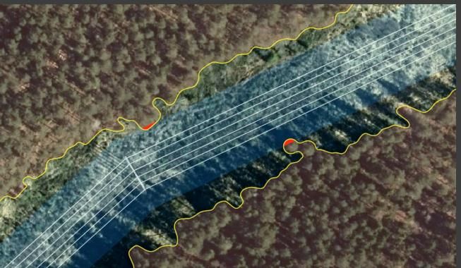
7Figure 2. The same corridor as in figure 1. The program has detected two trees that are too
close to the power lines (Spacept, 2020).
1.1.3 Satellite methods
Satellites here refers to the platform for remote sensing that provides the possibility for
obtaining imagery from space, unlike airborne or ground based methods. The data needed is
obtained from commercial or governmental earth observation satellites which can be of
different types. There are a number of satellites in the earth’s atmosphere today, but they are
majorly built for other purposes than earth observations, usually telecommunication and
scientific observations (Konecny, 2004).
1.2 Objectives
1. What are the advantages and disadvantages of satellite methods for power line
inspections?
2. Is it technically possible to apply satellite surveillance of power lines to estimate wood
volume of a forest?
1.3 Demarcation of - and motivation behind the
objectives
This report’s focus is limited to Sweden. It is convenient to limit the study to a single country,
since the topic of this report is dependent on a certain natural environment, which may vary a
great deal between different countries. The reason for choosing Sweden is because it is a
large country with big forest areas and long power line corridors, and it is also the country in
which Spacept is working.
1.3.1 Power line corridors
When choosing what infrastructure inspection to investigate, the choice has been limited to
only power line inspection. The reason for focusing on satellite methods for power line
8corridor inspections is that this is an emerging field that is not yet widely investigated. Urban
areas do not have the same need for remote infrastructure inspection as much as the
countryside does, where large power line structures usually are situated. Infrastructure in
urban areas is more accessible to inspect, in terms of vehicle-friendly nature and that it is
close by to inspectors, unlike infrastructure far off in inhabited areas. Also, some
infrastructure in non-urban areas is not in the greatest need of automated inspection if it is
visited by people frequently. A couple of examples of such infrastructure is highways and
railways. An error in such infrastructure has a higher chance of being reported than an error
in a power line that is placed far away from people.
When examining the advantages and disadvantages of monitoring power line corridors, the
focus is on optical and radargrammetry satellite methods. Today this field is dominated by
airborne LiDAR methods that provide three-dimensional information about a given area by
sending out pulses of laser from above to measure distance (National oceanic and
atmospheric administration, 2020). However, as the supply and quality of satellite imagery is
said to steadily increase, new opportunities that are not yet widely investigated emerge.
LiDAR methods will not be further investigated in this report, since these areas already are
thoroughly researched. The focus has been narrowed down and divided into two; technical
and economical. Firstly, the technical part will investigate the main technical advantages and
disadvantages when it comes to remote powerline inspections. Secondly, the part covering
economical aspects will investigate the economical dito. The vast majority of these methods
are based on optical satellite data, but the field of radargrammetry satellite data used for this
purpose will also be briefly reviewed.
1.3.2 Forest volume estimation
As a thanks to Spacept for helping with the first question of this report, a request of theirs to
investigate what other business areas than infrastructure inspection a company like Spacept
may be suited for, have been accepted. This is useful for them if they want to expand their
number of offered services. The forest industry and the particular service of estimating forest
volume with the technology of Spacept is the main focus for the second objective, as it is vital
for a forest company to know the volume of its forest in terms of actual wood. This volume is
what makes up the main worth of the company.
Since satellite power line inspection demands a geoinformatics program that detects trees
and calculates their heights, forest volume estimation may be a suitable service for Spacept
to offer if they want to expand their business, because detecting trees and computing their
heights are assumed to be some of the most complicated parts of estimating forest volume.
Thus, it is suspected that there is a significant technical carry-over between inspecting power
lines and computing the volume of a forest. Furthermore, Spacept claims that satellite
surveillance in general is cheaper than both drone and airborne surveillance, which is shown
is in figure.3. Therefore, estimating forest volume with satellites instead of airborne vehicles
has a potential economic advantage.
9Figure 3. Spacept presents general pricing of surveillance per km for helicopter-, drone- and
Spacept’s satellite surveillance.
1.4 Expected results
1.4.1 Advantages and disadvantages of satellite methods for power
line inspections
The hypothesis in this report is that one technical disadvantage is to reach high enough
accuracy when it comes to differentiate the trees from other vegetation. By using the
vegetation index, it is easy to exclude everything that is not vegetation. However, to exclude
different types of vegetation from another is not achieved by the vegetation index. Therefore,
other characteristics of trees have to be used, such as shadows and height profiles, in order
for the program to recognize a tree. One economical advantage of satellite methods is
believed to be that they will be cheaper to use than the airborne alternatives.
1.4.2 Applying satellite surveillance of power lines to estimate forest
volume
It is expected that it should be possible to compute an estimated volume of wood for a given
forest if the following three parameters are known. The technology that this would require is
similar to the technology that satellite surveillance of power lines demands.
Firstly, the number of trees: As explained earlier, tree detection is used when inspecting
power lines. However, if the tree detection is similar when detecting trees in the middle of a
forest as it is when detecting trees on the border of a forest at a power line corridor, it is not
known. Secondly, the height(s) of the trees: Spacept is developing a Digital Elevation Model
(DEM) to compute the height of a tree in a satellite image. They do this in order to
differentiate trees from other vegetation, to be able to see when a tree is too close to a power
line corridor. If they succeed, they would be able to successfully execute the second point
above. Lastly, the diameter(s) of the tree trunks and/or tree crowns: It is suspected that there
is a relationship between the age and average diameter of the tree trunk and/or tree crown
for each tree species, and also that most forests are largely homogenous, which would make
it easy to know the species for the majority of the trees. Thus, if one knows the age, he/she
10may be able to estimate the diameter of the tree trunk or crown. When a forest area is
harvested, most trees are cut simultaneously and only a few are spared (Sempler, 2011).
This should mean that most trees in a certain area have the same age, and consequently the
age of the trees of this area would be no problem to keep track of. If it is correct that there is
a relationship between the age of the trees and their average diameter of their trunks and/or
crowns, one should be able to compute an estimated average diameter for the trees in this
area with their known age.
1.5 Literature review
Surveillance used for power line inspection will be reviewed and especially satellite
surveillance and tree detection technologies for power line surroundings. The general area of
vegetation detection, however, will only be briefly covered. Furthermore, the more general
field of automatic surveillance and infrastructure inspection will not be investigated since the
focus in this essay is power lines.
1.5.1 Vegetation monitoring
Vegetation monitoring studies have covered tree species identification, extraction of
vegetation, height estimation of trees and determining how close to power lines trees are
growing. Cai & Walker (2010) have compared different methods for height determination and
have reported higher accuracy for ALS (Airborne Laser Scanning) than for aerial methods.
When focusing on larger areas a range of methods including SAR radargrammetry, ALS,
satellite and aerial stereo imagery, Yu et al (2015) have reported that the majority of these
also have been providing good estimations. Even though the ALS vegetation identification
research on power line corridors is sparse, ALS for more general applications of vegetation
mapping has been thoroughly investigated with good results.
They have compared different methods for remote sensing forest inventory, while focusing
on 3D point clouds. They have concluded that ALS measurements perform with higher
accuracy than other methods, except for monitoring on regional or country levels, where
large coverage of space-borne platforms can be utilized. A growing reliance on 3D point
clouds for remote sensing in forestry has been anticipated, as information about tree height
is the most important source of information for these kinds of forest measurements.
Vegetation detection from airborne platforms is a well-researched topic, especially for the
purpose of maintaining plantations and forests (Culvenor, 2003). A comparison of accuracy
between different methods for forest measurements has showed that more details are
provided by land and air-based systems, but that they are impractical for covering large
areas (Yu et al, 2015).
There is a number of studies showing promising results for general forest estimations using
radargrammetry methods, for instance by Solberg et al (2015), Karjalainen et al (2012),
Perko et al (2010) and Chen et al (2007). However, there is only limited research on this
topic related to individual tree detection, as SAR for long only has been providing low
resolution imagery. Stilla et al (2014) have highlighted the need for new detection algorithms
that are adapted to the specific conditions of radargrammetry imagery, as this type of data
usually needs more robust methods to compensate for speckle and other consequences of
the coherent image process. They also have discussed the limitations of SAR remote
sensing for this purpose and suggest that multi view InSAR methods can be useful to
overcome these problems.
11There are also methods using optical satellite data. Neigh et al (2014) have concluded that
IKONOS stereo imagery provides accuracy results comparable to ALS systems when used
for tree height estimations, given that high resolution DTMs are available. Xiao et al (2018)
have presented a method using both the multi view and spectral information in stereo
imagery, applying top-hat morphological operations and revised pixel segmentation to filter
out tree areas with high accuracy. It is also suggested that further improvements can be
made by using tree templates of more varying sizes. Xiao et al (2020) have used
unsupervised treetop detection combined with deep convolutional neural networks to process
multi view high resolution satellite imagery and orthophoto.
1.5.2 Remote sensing for power line corridors
Regarding the field of power line corridor monitoring research, various methods have been
presented and tested. Some articles have been covering reviews of computer vision
approaches (Mirallès, 2014), comparisons of radar, aerial and laser scanning methods (Mu
et al, 2009) and future scenarios of the field (EPRI, 2020). The aspects of power line
surveillance focused on vegetation have also been discussed in a number of articles. For
instance, by Ahmad et al (2013), Ahmad et al (2011), Mills et al (2010) and Ituen et al (2010).
Matikainen et al (2016) have summarized and analysed different types of remote sensing in
regard to power line corridor surveillance. This review concludes that the majority of studies
covering power line corridor surveillance have been focused on automated extraction of
network components, and that fewer have been addressing the question of mapping the
surrounding vegetation of the corridors.
However, there are still a significant number of studies in this field, and especially methods
using optical satellite and aerial imagery have achieved much attention. They suggest that
further attention should be given to emerging fields of remote sensing, such as laser
scanning and UAVs, and calls for larger scale tests of different monitoring approaches to be
done, comparing the capacities of algorithms and data sources available. These tests need
to verify and demonstrate the capabilities of mentioned methods in different practical
conditions and settings.
This review identifies a trend of most research being focused on automated methods rather
than visual and manual methods, connecting this to the overall need of limiting costs
associated with the latter. It highlights the need for several different methods of power line
inspection for infrastructure companies. It especially points out that only a few articles have
been focusing on methods for companies and researchers to overview damage caused by
natural disasters, and that more research is needed in this field (Matikainen, 2016).
1.5.3 Satellite vegetation monitoring for power line corridors
Ahmad et al (2011) have been studying vegetation growing close to power lines, suggesting
an approach based on satellite stereo images. Their idea has been to use NDVI-information
from merged multispectral and panchromatic imagery for vegetation detection, and then
combine it with a DEM from stereo imagery to identify trees encroaching power lines.
Kobashi et al (2009) have been using multispectral stereo satellite imagery when they
introduced an, at the time, novel concept of approaching the same problem. They have
identified trees from NDVI aerial-adjusted thresholds and vegetation height was calculated
from stereo imagery. Moeller (2006) also have used this type of satellite imagery, specifically
from Quickbird, to identify vegetation within the zones of danger.
12Häme et al (2016) have presented a study suggesting that satellite imagery can be used to
find individual trees encroaching power line corridors. They also suggest that satellite
imagery can help detecting general vegetation changes surrounding the power lines as well
as estimating the heights of growing trees in areas of interest. The results have been
described as satisfying, providing the possibilities to extract valuable information about
maintenance status. Mills et al (2010) have compared multi spectral images techniques with
LiDAR for individual tree and pole detection in power line corridors, receiving significantly
higher detection rates for LiDAR than the satellite method.
To summarize this review, the field of power line satellite inspection is not widely
investigated. Some methods have been proposed, but not many have been evaluated.
Something that is recurring is the prediction that the satellite field of monitoring will increase
in the coming years, and therefore it is of importance to further investigate what challenges
are yet to be overcome. Today airborne LiDAR methods are dominating, and novel UAV
methods as well as satellite inspection methods are predicted to be increasingly used.
132. Methodology
In order to investigate the advantages and disadvantages of satellite powerline inspection, a
short literature review has been made, which covers the subjects of single tree identification
from satellite imagery and satellite power line corridor surveillance. Based on the chosen
objective, the ambition has been to not only answer it by a literature review but also from the
perspective of a company working within this specific field of infrastructure inspection. Two of
the co-founders of Spacept have been interviewed several times for this purpose; Sergiu
Iliev, Founder and Co-CEO/CTO, and Arshak Ulubabyan, CTO and Co-Founder. The
questions they have been asked are the following: What methods have you used and are
planning to use for satellite based powerline inspections?, Why is Spacept focusing on
satellite based powerline inspections? and What are the biggest challenges associated with
development of satellite based powerline inspections for Spacept?. These questions have
been phrased in general terms to provide an overview of different advantages and
disadvantages from Spacept’s point of view.
To answer the second question, two specialists in the field have been contacted; André
Wästlund, who is a Forest specialist at SCA Skog and Henrik Persson, who is an Associate
professor in Remote Sensing of Forest at the Swedish University of Agricultural Sciences
(SLU). There has been a continuous email correspondence with André Wästlund and an
online meeting with Henrik Persson. SCA Skog is one of the leading forest companies in
Sweden and SLU specializes in remote sensing of forest with different techniques, one of
which is satellite surveillance. To have them as sources means gaining knowledge from both
the industry as well as from an academic perspective. The questions to Henrik Persson and
André Wästlund are Do you find the expected result accurate and realistic? If not, what are
the main problems and what should be changed? and What is the approximate resolution
needed to provide a satisfying result? Some of the information that has been given from
these two verbal sources has been confirmed with scientific reports. This confirmation check
has been carried out as a judgement sample to test if the information from the verbal sources
is backed up by legit scientific reports. It has indicated that the information from the verbal
sources is valid.
143. Results
3.1 Advantages and disadvantages of satellite
methods for power line inspections
Matikainen et al (2016) have reviewed methods for power line inspection and suggest that
satellite imagery methods are useful for monitoring larger areas of interest on a coarse level.
However, the results are less satisfying when it comes to identifying individual trees. This is
linked to a need for higher satellite spatial resolution for tree identification than what is
generally available today, compared to airborne and land-based methods.
Their review also highlights some problems associated with satellite imagery methods, which
is that the weather dependency of satellite imagery hinders a reliable image acquisition and
the high cost of high-quality imagery. The review suggest that these might be factors of
disadvantage, limiting a broader use of satellite methods for power line monitoring. However,
one advantage that has been highlighted is the possibility that the satellite methods for power
line monitoring may be a cost-effective alternative for general monitoring of forest growth in
the near future (Matikainen et al, 2020).
3.1.1 Technical aspects
Being able to identify single trees in satellite images has been described by Iliev (S Iliev
2020, personal communication, 9th April) as one of Spacept’s main technological focuses.
Through the use of deep learning algorithms, the ambition is to be able to automate this
procedure in the long run to augment ground and aerial inspection, with the ambition to reach
above 95% detection accuracy (S Iliev 2020, personal communication, 9th April).
There are different approaches to the problem of identifying trees that have been suggested
or proven to be useful. The accuracy of the methods is evaluated in different ways in different
studies. Some types of accuracies include the percentual fraction between estimated and
calculated results (fraction accuracy, where higher percentage is better), detection accuracy
(where higher number is better) and RMSE (root mean square error, where smaller
percentage is better).
One method is to use solely the spectral properties of high-resolution spatial satellite images
with algorithms to identify trees. This, however, is associated with problems of reaching high
enough accuracy for practical use, due to complexity and lack of detail. Gonçalves et al
(2017) have used 0.5-0.7 m panchromatic imagery for this purpose, reporting 83-93%
fractional accuracy and Bao et al (2015) have used the same resolution with 50-85%
fractional accuracy.
The general accuracy for these methods is not widely investigated, even though Xiao et al
(2018) have reported achieving high detection accuracy (0.6-0.86) when identifying
individual trees for 0.3 m multi view imagery for varying ground covers and regional areas.
When comparing methods using 0.15-0.05 m resolution multi spectral satellite imagery and
LiDAR imagery, Mills et al (2010) have received higher detection accuracy for the latter, 96
respectively 98%, but also stressed that better performance is required for both methods to
be able to detect trees at highly satisfying rates.
Other approaches have been proposed by Ahmad et al (2011), who do not specify any
resolution, and Moeller et al (2006), using 0.6m panchromatic resolution. Their methods
15involve DEMs combined with multispectral and panchromatic imagery to combine spectral
and height properties for the purpose of identifying trees in an image. Neither of these two
studies presents any results as they are just proposed methods. Kobayashi et al (2009) have
also proposed the procedure of combining NDVI aerial-adjusted thresholds with vegetation
height from 0.6 m panchromatic stereo imagery to identify power line encroaching trees, but
do not evaluate the resulting accuracy.
Häme et al (2016) have used multispectral satellite imagery with 6m and 0.5 m resolution to
find individual trees encroaching power line corridors with satisfying results. They have used
Probability and AutoChange algorithms, with height detection algorithms being calibrated
with the help of laser scanning of a template area for higher accuracy, reporting a 96%
detection accuracy. Qayyum et al (2014) have presented a method of applying an improved
stereo matching cost function of 0.6 m resolution multispectral satellite imagery. They still
evaluate this as insufficient, even though not reporting any numbers of accuracy, and
conclude that its biggest advantage is a higher computation speed than existing algorithms.
Xiao et al (2020) have shown promising results for identifying trees with 0.3 m resolution
multi view imagery, evaluating the detection accuracy as 73-86%.
All methods described above are based on optical satellite data, but there is also radar
satellite data that can be used for this purpose. SAR measures physical characteristics with
microwaves. It sends out the microwaves and measures the ones that are reflected back,
this makes a satellite using SAR available to interpret ground data even if there are clouds or
fog in the way, which makes it able to work during all weather conditions (Centre for remote
imaging, sensing and processing, 2020).
Until recently SAR satellites have only produced lower resolution imagery than comparable
optical satellites, usually around 1 m. The use of SAR satellite imagery for single tree
detection therefore has not been a well-researched topic (Men et al, 2017), but now there are
new satellites available. In studies comparing SAR to other methods of tree volume
estimations and 3D point cloud forest mapping, both using 1 m resolution imagery, the
studies reported that SAR has produced significantly worse results than optical satellite and
airborne methods. Rahlf et al (2014 ) received results with 23% RMSE, compared to 12% for
ALS measurements, and Yu et al (2015) achieved between 9.5 and 30%, compared to 5-
15% for ALS.
The new higher resolution satellites open up for the possibility of further research in this field,
as only 1 m resolution imagery have been used in the studies above. New SAR small
satellites, developed by the company Iceye, will provide commercial SAR imagery with 0.25
m resolution (Airline Industry Information, 2019), which Iceye (2020) claims will reduce the
cost of SAR satellite imagery. The new TerraSAR-X NG, launched in 2018, also had 0.25 m
resolution (Men et al, 2017).
Stilla et al (2014) have discussed the technical limitations of using SAR satellite imagery for
single tree identification, mentioning the complex shape of the tree with weak backscattering
as a problem for radar methods to picture. The authors also bring up that only the side of the
tree that is facing a sensor can be detected and reconstructed, which calls for the need of
multi view InSAR methods to overcome this problem. They have stressed that there is a
need to develop new detection algorithms that are adapted to radargrammetry imagery
conditions, as this type of data usually needs different adjustments to compensate for image
quality problems compared to the ones used for optical imagery.
3.1.2 Economical aspects
16Iliev describes how the viability of satellite imagery for Spacept is not only a matter of existing technology, but the cost of obtaining imagery for areas of interest also needs to be taken into account. Today there are a number of sources providing satellite imagery for commercial use, but the cost of developing and maintaining high resolution satellites is still a large factor in the resulting cost of the images. There is also a tendency of more recent data being more expensive, as they require the orbital manoeuvring of the satellite over an area of interest, rather than passively capturing the images on its normal overpass (S Iliev 2020, personal communication, 9th April). Spacept relies on hardware sources for getting satellite imagery, managed by their network of suppliers. They buy their data from companies such as Google, which offers both satellite imagery and aircraft images, like Landsat, but do not own their own satellites (Google Earth Help, 2020). Among other suppliers are Airbus and DigitalGlobe, specialized in high resolution (
The results are summarized in Figure 4 below.
 Advantages                                 Disadvantages

 Good prospects - the rapid                 The height detection algorithms for monoscopic
 development of new satellite               imagery turned out to be efficient only on flat terrain
 technology is promising for the            and easily separable shadows. This limits the amount
 possibility to improve tree                of data it can be applied on, and the method is also
 identification results.                    yet not tested in reality.

                                            There are also other possible technical limitations
                                            suggested by different studies, such as a potential
                                            dependency on expensive stereo imagery.

 95% detection accuracy - the               No present satellite methods have proven
 accuracy goal for Spacept - is fulfilled   comparable or higher accuracy when compared to
 by some of the evaluated methods.          LIDAR methods in surveys.

                                            There is also a lack of evaluated methods - not many
                                            methods for satellite-based tree identification are
                                            both proposed and evaluated. The ones that are
                                            evaluated are also hard to compare to each other as
                                            they are using different methods for calculating.

 Satellite methods are pointed out as a     It is hard to evaluate the more exact pricing for these
 possibly more cost-effective               satellite methods as they are still in the development
 alternative to conventional airborne       phase.
 methods by some studies, especially
 as the prices for satellite imagery are
 sinking.

 There are a number of providers of         Optical satellite imagery is weather dependent,
 satellite imagery on the market,           limiting the availability of such data.
 covering the whole globe, which
 easily satisfies the required temporal
 resolution of one year.

 New SAR satellites with 0.25 m             SAR satellite imagery has a number of factors
 resolution creates new possibilities to    suggesting this type of data will not be useful for the
 achieve higher accuracy, as the            purpose of tree identification. This includes sparse
 research so far is based only on lower     research of this area, bad results when compared to
 resolution imagery.                        other methods and the fact that trees are hard to
                                            detect from radar imagery.
Figure 4. The advantages and disadvantages of satellite-based power line inspections based
on the literature review and Spacept sources.

3.2 Applying satellite surveillance of power lines to
estimate forest volume
Wästlund says the following in regard to the expected result of this report. Firstly, number of
trees: Except for trees on the edge of a forest, differentiating trees in a forest with satellite
data is harder than one may believe. Finding the dominating trees is relatively easy, but
finding the suppressed ones is not. This would risk leading to a negative bias, depending on

                                                18
the forest. Thus, if the forest is well-cared for and single-layered, a geoinformatics program
should be able to count the number of trees fairly accurately. Meanwhile, the program would
probably not do as good with a multi-layered forest or a forest that is not well-managed.
Secondly, tree height(s): Height estimations of trees in a forest are fairly good today if one
uses stereo images. This may be done either for individual trees or an area.
Lastly, tree diameter(s): There is a correlation between age, diameter of the crown and size.
However, the crown diameter depends on how the forest has been managed. If a forest is
compact, the tree crowns tend to be smaller compared to those of a sparse forest. This may
lead to the following problem when applying this relationship to estimate wood volume: when
a forest company executes thinning, the remaining trees will have smaller crowns than they
would have had if the forest had been sparse from the beginning. The computer program that
tries to compute an estimated wood volume based on images from above of this forest may
assume that the trees are smaller than they really are, due to the smaller tree crowns (A
Wästlund 2020, personal communication, 21th April).
However, Wästlund says that the expected result is basically correct. These principles are
what today’s calculations are based on, but they are so far mainly used by airborne LiDAR (A
Wästlund 2020, personal communication, 21th April). Wästlund continues to explain that the
assumption that most trees in the same area have the same age because of how tree
harvest is done, is only correct for forests that are about 70 years old or younger. The reason
is that tree harvest was not done in the same way before the 1950s. Before then, trees were
more randomly cut down and thus the age between trees in the same area varies greatly if
the trees are older than 70 years old (A Wästlund 2020, personal communication, 21th April).
The assumption in the expected result that there is a correlation between the age of a tree
and its tree trunk diameter is correct. Wästlund also states that while the tree trunk diameter
is not as affected by the management of the forest as the crown diameter is, there are still
other factors that affect the tree trunk diameter more than the height. Such a factor is the
fertility of the ground, and this makes it harder to estimate the tree trunk diameter with only a
known height (A Wästlund 2020, personal communication, 21th April).
This agrees with the findings of scientists at the US Forest Service (2016). They compared
measurements of longleaf pine and four swamp tree species during their growth. They knew
from the beginning that the tree trunk diameter of a tree in general increases faster than the
tree height with an allometric coefficient of two-thirds. What they found, though, was that the
diameter of some of the species increased in connection with rainfall, while others were not
(US Forest Service, 2016). Lastly, Wästlund explains that the assumption that most forests
are homogenous is wrong. They often consist of different species (A Wästlund 2020,
personal communication, 21st April).
It is challenging to derive the height of a high, dense forest through monoscopic images (H
Persson 2020, personal communication, 12th May). Single images might be sufficient if the
ground is exposed around the tree that you are measuring height of. Thus, it is more likely to
work when measuring height in a sparse forest or a young forest due to the lower height.
When measuring a dense forest, stereoscopic images provide the opportunity to derive
surface height measurements using photogrammetry. The ground level is often available
from laser data and then, the forest height can be computed. To measure the height with
satellite data, one needs a certain minimum resolution (H Persson 2020, personal
communication, 12th May). Persson et al (2013) compared the RMSE of estimating biomass
at stand and sub-stand level by combining a CHM (Canopy Height Model), which is derived
from laser data, with satellite data of different resolutions. The result is shown in figure 5.
19ALOS SPOT-5 Terra ASTER (15 m)
PRISM (2.5 (10 m)
m)
Relative RMSE of aboveground 22.4% 29.2% Not shown
biomass at stand level
Relative RMSE of sub-stand 10.5% 20.6% Not presented in the report due
analysis to too poor performance
Figure 5. The relative RMSE of combining a CHM with satellite data of 2.5 m, 10 m and 15
m, respectively at stand and sub-stand level.
204. Discussion
4.1 Advantages and disadvantages of satellite
methods for power line inspections
The hypothesis in this report was that one disadvantage would be reaching high enough
accuracy when identifying trees in the satellite imagery. This turned out to be true, and even
though a number of methods have been proposed to solve this problem, not all of them are
evaluated. Those who are have used different data and methods for computing the accuracy,
making them unusable for comparisons between each other. What can be seen is that the
goal of Spacept, to achieve 95% detection accuracy, is fulfilled by some of the presented
methods. However, these accuracies, like the case Mills et al (2010) describe when they
achieved 96% detection accuracy, are still lower than the LIDAR method they are compared
to. Therefore, they conclude that this satellite accuracy result should be considered not high
enough.
To know whether this problem will be resolved in the near future, it is relevant to know if the
technology of today is enough for this purpose. It seems like this question is not easily
answered, as one disadvantage is that most of the proposed methods are not thoroughly
evaluated and the ones that have been evaluated are making differing conclusions in the
question of accuracy. Further evaluation is something that needs more attention and would
be a topic of research that can provide more sturdy answers regarding the state of this field
of forest surveillance. Future research should evaluate different algorithms and data sources,
run them on test samples from different environments and compare them to each other to be
able to make conclusions about performance and accuracy.
Multiple studies present advantages of using satellite methods, suggesting that these
alternatives will be widely used for power line inspections in the near future. This is based on
the assumption that the question of accuracy eventually will be solved, in conjunction with
the overall increase of satellite imagery resolution associated with the rapid development of
new technology.
One hypothesis regarding economical aspects was that it would be cheaper than
conventional alternatives. As the exact prices were not investigated and compared in this
report, it is not clear whether this turned out to be true or not. Furthermore, the lack of
evaluation of satellite methods, especially of methods that have been proven successful,
means that it as of now might not even be possible to evaluate if it is cheaper, as there is no
point in starting to calculate the price for methods that have not been proven useful.
However, the investigation of economic aspects showed that for commercial actors like
Spacept, the question of if it is possible to perform inspections at a lower price than today’s
conventional methods offer is heavily dependent on what types of data that will be required
to acquire desired results. If it turns out that it is possible to identify trees with high accuracy
from monoscopic satellite imagery, this could be an advantage in the form of a cheaper
alternative to LiDAR based methods, but the required amount of work for each method also
needs to be taken into account. If monoscopic imagery proves to need more complex
algorithms and rigorous manual annotation to achieve desired accuracy, this will also be a
disadvantage in the form of higher costs. Another disadvantage is also that the height
detection algorithms for monoscopic imagery turned out to be efficient only on flat terrain and
easily separable shadows, limiting the amount of data it can be applied on.
21Some other disadvantages that were highlighted in the review were the weather dependence
and the risk for competition between customers in the commercial field when available data
is limited. Regarding the question of weather dependence, this is a widely known problem
with satellite surveillance that partially can be solved with different image enhancement
methods, but with today’s technology it is not likely to be completely solved and therefore
limits the usage of optical satellite surveillance methods. On the other hand, the required
temporal resolution turned out to be only one year, as the inspections are made to prevent
falling trees rather than to discover already fallen ones, that would require much higher
temporal resolution. As trees grow relatively slowly, they will not be able to grow too much
between each yearly inspection. This lowers the cost for getting the right data because the
price is higher the more recently it is retrieved.
One advantage of SAR satellite surveillance is that it effectively reduces the temporal
problem as it is independent of weather conditions. Meanwhile, there are other
disadvantages associated with this method of surveillance. The higher price and lower
resolution compared to optical satellites also limit the overall market interest for SAR
imagery. However, companies such as Iceye might change this when launching SAR
satellites with resolutions around 0.25 m, comparable to optical satellites, but without the
weather dependency.
Overall, SAR satellite surveillance for tree identification has disadvantages in the form of the
fact that it is a sparsely researched topic. Also, the few existing studies suggest that the
complex tree shape might be a great challenge to identify from radar imagery. Additionally,
the reports investigating SAR accuracy for satellite powerline inspections have not used the
newer high-resolution imagery, but instead used imagery with only 1 m resolution, which
might make these comparative reports slightly outdated. It would be relevant for future
research to examine what accuracy the new 0.25 m resolution imagery can provide, and if it
is possible to overcome the radar related problem with tree identification.
One topic that is only briefly touched in this thesis is LiDAR surveillance methods for power
line inspections. The review showed that LiDAR is the most widely used method today and
the one producing the highest accuracy, and therefore it would be relevant to compare the
satellite methods of interest more systematically to LiDAR airplane surveillance. To be able
to do this it can be required to do new comparative studies, as the existing ones are using
varying methods for presenting accuracy, making them non-comparable.
4.2 Applying satellite surveillance of power lines to
estimate forest volume
The hypothesis of how technology of satellite inspection of power lines can be applied in the
forest industry to estimate forest volume is to a large extent correct in principle and similar to
the method that is used today. However, some parts of the hypothesis are not entirely right.
When differentiating trees in a forest, it is finding the less dominant trees that is hard. The
difficulty of this depends on how well managed the forest is and if it is single- or multi-
layered. Failing to detect the suppressed trees will lead to a negative bias, by
underestimating the number of trees.
The assumption that there would be a correlation between the age of a tree and its diameter
in the crown or trunk turned out to be correct. There is a correlation between the age and
both crown and trunk, for each species. These two diameters are affected differently. Forest
management is a large factor of the development of the tree crown, while precipitation highly
affects the development of the tree trunk of some tree species. Both of these correlations
may cause problems. For example, if a forest is badly managed and tight, the tree crowns
22will be smaller than those of a sparse forest. This can be misleading for a geoinformatics
program that puts a great emphasis on the diameters of the tree crowns when estimating the
forest volume. A problem with the correlation between precipitation and tree trunk diameter
is, firstly, that the geoinformatics program that estimates the forest volume may need
precipitation data in order to make satisfying estimations. Secondly, since precipitation
affects the trunk diameter of different species so differently, the program may need to know
what the tree species the tree in the image is. This may be hard to do, since Wästlund
proved the belief that most forests in Sweden are fairly homogeneous, inaccurate. One
hypothesis was that the age of the large majority in each forest is easy to know, since almost
all trees in a certain area are harvested simultaneously. This has proven to only be true for
trees that are up to 70 years old. For forests that are older than this, it is not that easy to
know the age of each tree.
Unlike with satellite inspection of power lines, monoscopic imagery is probably not sufficient
today to provide volume estimation of forests, unless the forest is particularly sparse or
young. The reason is that monoscopic imagery only works if at least some ground around the
tree is exposed on the image. All trees that are relevant to detect and measure height of,
when inspecting power lines, are on the border between the forest and the power line
corridor. This means that at least some ground around them, the ground that is located in the
corridor, always will be exposed in the image. When the aim is to measure the volume of a
forest, however, many trees will not have any ground at all around them shown on the image,
which makes monoscopic imagery insufficient to compute tree height. There is also a
requirement of minimum resolution. A pixel size of 15 m offers biomass estimation of poor
accuracy, 10 m pixel size provides better but not very satisfying accuracy, while pixel size of
2.5 m offers an accuracy which is considered fairly good.
23You can also read