Model Development Report - Greater Wellington Regional ...
←
→
Page content transcription
If your browser does not render page correctly, please read the page content below
Model Development Report Date: December 2012
Contract C3079
                      Wellington Transport Models Tender
                      WTSM update and WPTM development

                      Wellington Transport Models

                      Model Development Report

Prepared By                                                     Opus International Consultants Limited
               Katie Levin / Andy Wilson / John Pell / Marius   Wellington Office
               Roman
               Transport Planners / EMME modellers              Level 9, Majestic Centre, 100 Willis Street
                                                                PO Box 12003, Wellington 6144
                                                                New Zealand

Reviewed By                                                     Telephone:      +64 4 471 7000
               Bruce Johnson / David Dunlop                     Facsimile:      +64 4 471 1397
               Technical Leader / Project Manager
                                                                Date:           December 2012
                                                                Reference:      c3079 final development
                                                                                report 201212.docx
                                                                Status:         Final
                                                                Revision:

© Opus International Consultants Limited 2012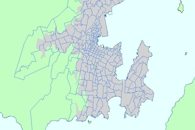
Draft Development Report

Acknowledgements:
The WTSM and WPTM Project was developed in partnership between Greater Wellington
Regional Council (GWRC), Opus International Consultants, Arup, and a number of other sub
consultants working for GWRC. Sub consultants have been referenced in the documentation and
provided inputs into the data collection, economic parameters, demographics and forecasting for
the project.
The model documentation has been largely produced by Opus for WTSM and the general
modelling system and Arup for WPTM, with inputs from GWRC and other sub consultants where
appropriate.
John Bolland was appointed by GWRC as the independent peer reviewer and has been involved in
the project from initial investigation through the sign off of the modelling system and the
appropriate model documentation.
Draft Development Report

Executive Summary:
The GWRC carry out a core transportation planning and land-use function within the Wellington
Region and the use of transportation modelling tools and projections is a mechanism to assist with
strategic assessment, policy making decisions, monitoring and support the development of plans
and projects.
The Opus and Arup team was appointed by GWRC in partnership with NZTA to update the current
2006 WTSM modelling system and develop a new public transport model (WPTM). This project
was to be commissioned following the completion of the 2011 Census, however due to the
Christchurch Earthquake this Census was postponed. Although the latest Census information was
not available, GWRC and NZTA determined that the existing modelling system needed to be
updated and a new passenger transport model created. This decision was based on a large
number of significant transport projects being developed in the region and the importance of
ensuring that these projects could be suitably assessed, they included:
        •   Wellington PT Spine Study;
        •   Wellington Regional Rail Plan;
        •   Wellington Bus Review; and
        •   The Wellington Northern Corridor Roads of National Significance (RoNS).
The 2006 WTSM model had limited PT capability and was not based upon detailed survey
information, while the model itself also needed to be updated with current information and revised
forecast projections.
GWRC determined that the WPTM would be created as an AM and Inter peak model with
significantly more model definition than WTSM, this resulted in a 780 zone system which was
linked to the 225 zone system utilised by WTSM.
The Project utilised an extensive data set collected for PT and vehicle travel between March and
October 2011 and included; rail and bus surveys collected at stops, stations and on board;
electronic ticket information; bus real time information; Wellington City cordon counts (all modes);
vehicle loop counts; and journey time data. Information and data was utilised for demographics,
forecasting and land-use projections.
The modelling system was developed and reported based upon a series of technical notes that
were developed for key parts of the model development and project delivery. These include:
        •   TN1 Network Preparation
        •   TN2 Survey Sampling Methodology
        •   TN3 ETM Data Cleaning and Analysis
        •   TN5a Bus Intercept Survey Analysis
        •   TN5b Rail Intercept Survey Analysis
        •   TN6 WPTM Specification
        •   TN7 PT Matrix Development
        •   TN8 Airport Survey Methodology
        •   TN9 Airport Model WTSM (draft document and not part of the core package)
        •   TN13 Base Model Car Ownership
        •   TN15 Input Parameters
        •   TN16 WTSM and WPTM PT Assignment Comparison
        •   TN17 Validation Guidelines and Criteria - WTSM and WPTM
        •   TN18 WTSM Calibration and Validation
        •   TN19 WPTM Calibration and Validation and Addendum to TN19
        •   TN20 WPTM Forecasting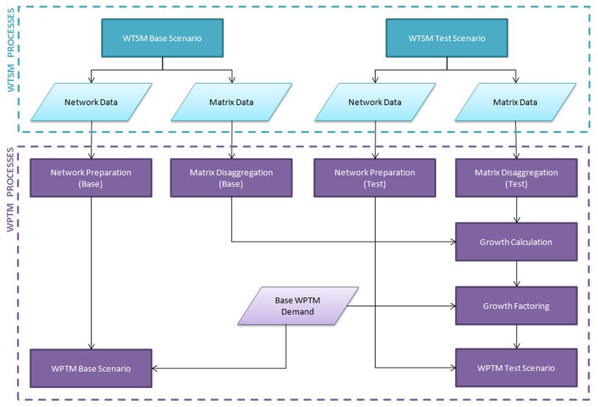
Draft Development Report

         •   TN21 Model User Guide and WTSM – WPTM Interface (live document and not part of
             the core package)
         •   TN22 WPTM Sensitivity Testing
         •   TN23 Future Year Base Networks and Services
         •   TN24 Baseline Forecasting Report
         •   TN29 Demographic Inputs to WTSM

Key features of the WTSM and WPTM project include:
         •   Network now covers all current PT links and bus stops;
         •   PT lines comprehensive update using General Transit Feed information;
         •   Intersection lane capacities within Wellington CBD linked to the Wellington Traffic
             Model;
         •   New assignment options in EMME;
         •   Amended HCV matrices;
         •   Consistency and compatibility between WTSM and WPTM;
         •   Updated economic forecasts and projections; and
         •   Updated demographic and forecast information.

An airport model has also been developed as part of the project, however due to timeframes and
the very low PT demands from the Wellington Airport it was decided that the model would not form
part of the validation process or core modelling system at this time.
WTSM has been successfully validated to a similar standard to other strategic 4 stage models
nationally and internationally, resulting in a better level of validation than the 2001 model and a
similar level to that of the 2006 model.
WPTM had significant data sources and was a new model; as a result the validation was extremely
good when compared with other international models. The level of validation and model definition
provides a robust tool for PT assessment, planning and decision making.
The modelling system has been designed so that WTSM can be used in isolation to WPTM or in
parallel, allowing flexibility for the users and a level of detailed PT modelling which is significantly
more robust to that experienced using WTSM in the past.
The model has been considered fit for purpose to be utilised for strategic assessment, transport
planning and the extraction of demand matrices for more detailed project modelling for those key
projects identified above. Other projects in the region should consider the suitability of the
modelling system prior to utilising outputs.
During the model development process, the Opus and Arup team worked with a number of GWRC
staff and trained them to use the modelling system. This approach aims to ensure a robust
understanding of the modelling system, the models strengths and weaknesses, and ensure the
Region has a resource in which to carry out assessment, planning and delivery of transport policy
and projects during a significant time of change.
Draft Development Report
Contents
Acknowledgements: ...................................................................................................................... i
Executive Summary: ..................................................................................................................... ii
1 Introduction .......................................................................................................................... 1
1.1 Background .................................................................................................................. 1
1.2 Project Brief and Objective ........................................................................................... 1
1.3 Structure of This Report ................................................................................................ 1
2 Design Investigation ............................................................................................................ 3
2.1 Model Investigation Report ........................................................................................... 3
2.2 Airport Model Design .................................................................................................... 3
2.3 WPTM Model Design .................................................................................................... 4
3 Data Collection and Input Preparation ............................................................................... 5
3.1 Network Inputs.............................................................................................................. 5
3.2 Economic Research ...................................................................................................... 6
3.3 Demographic Research and Land-use Inputs ............................................................... 6
3.4 Traffic Counts and Airport Occupancies........................................................................ 8
3.5 Bus and Rail Counts ..................................................................................................... 9
3.6 PT Users Survey......................................................................................................... 10
3.7 Highway Journey Times Survey.................................................................................. 12
3.8 Base Observed PT Matrices ....................................................................................... 12
4 Model Development, Calibration and Validation.............................................................. 14
4.1 Base WTSM Development.......................................................................................... 14
4.2 WTSM Base Model Calibration and Sensitivity Testing ............................................... 15
4.3 Airport Model Calibration ............................................................................................ 16
4.4 WTSM Validation ........................................................................................................ 17
4.5 WPTM Base Model Development ............................................................................... 18
4.6 WPTM Base Model Calibration and Sensitivity Testing ............................................... 19
4.7 2011 WPTM Validation ............................................................................................... 20
4.8 WTSM – WPTM Transit Assignment Comparison....................................................... 23
4.9 WTSM – WPTM Interface ........................................................................................... 23
5 Model Forecasting ............................................................................................................. 26
5.1 Future Baseline Networks and PT Services ................................................................ 26
5.2 Forecast Parameters .................................................................................................. 26
5.3 Demographic Forecasting ........................................................................................... 27
5.4 Future Baseline Model Runs and Analysis .................................................................. 28
5.5 WPTM Forecast Model Design ................................................................................... 29
6 Conclusions and Recommendations: .............................................................................. 30Draft Development Report
1 Introduction
1.1 Background
Greater Wellington Regional Council (GWRC) has contracted the services of Opus
International Consultants and Arup to rebase and validate the Wellington Transport
Strategic Model (WTSM) and to complete the development of the Wellington Public
Transport Model (WPTM). The project team worked in partnership with GWRC to complete
this project, with significant input to the project being provided by GWRC staff and
resources.
The postponement of the 2011 Census to March 2013 means that the full recalibration of
WTSM will not be undertaken until a time after this update has been completed.
Consequently, this update will focus on ensuring that WTSM / WPTM is capable of
providing robust transport forecasting in the interim.
1.2 Project Brief and Objective
The overall objective of the project is to update the modelling tools maintained by GWRC to
a 2011 base and develop enhanced predictive capabilities for public transport usage. The
models are to be completed in a timely manner to provide the assessment platform for the
Public Transport Spine Study (Railway Station to Regional Hospital) ("the Spine Study")
and assist with other significant transportation projects in the Wellington Region such as the
Wellington Bus Review and the Roads of National Significance (RoNS) project. This project
will provide a modelling tool that is current and can better meet the needs of transport
planning, public transport development and land-use integration in the region.
1.3 Structure of This Report
This report summarises the approach taken in the update of WTSM to 2011 and the
development of the WPTM. It follows the flow chart in Figure 1-1 below which shows the
process of each step and how they inter-relate and the technical note that relates to each of
those steps. This report summarises those technical notes to provide an overview of the
modelling process and should be read in conjunction with the technical notes that provide
greater detail of the individual steps undertaken as part of the project.
The project process can be split in to four basic steps:
• Design Investigation;
• Data Collection and Input Preparation;
• Model Development, Calibration and Validation; and
• Model Forecasting.
1Draft Development Report
Model investigation and
planning
"Model Investigation Report"
1. Design Investigation
WPTM model design
Airport model design TN9
investigation TN6
DATA COLLECTION
Network data: GIS Data, bus Traffic counts TN18
stops, aerial photography, signal Network inputs TN1 Airport counts and occupancies
data and SATURN networks. TN1 TN8 Report and Technical Note Descriptions
Public transport service data:
Bus and rail counts PT surveys used to base Model Investigation Report
Paper timetables, Greater Public transport service model
Wellington General Transit Feed inputs TN1 ETM and manual counts matrices development TN1 Network Preparation
data TN1 TN2, TN3, TN5a, TN5b
TN2 Survey Sampling Methodology
2. Data Collection, Input Preparation Economic research: PT user surveys
Base observed matrices TN7 TN3 ETM Data Cleaning and Analysis
Parameters inputs TN15 Origin Destination, Trip Purpose, TN5a Bus Intercept Survey Analysis
GDP, CPI, Fuel Prices, Parking
charges, PT FaresTN15 Access/egress Mode, Time of Day TN5b Rail Intercept Survey Analysis
TN2, TN3, TN5a, TN5b
TN6 WPTM Specification
Demographic research: TN7 Public Transport Matrix Development
2011 Landuse, demographics, car Demographic and landuse TN8 Airport Survey Methodology
Highway journey time surveys
ownership estimation TN29, inputs TN29, TN13
TN18 TN9 Airport Model WTSM*
TN13
TN13 Base Model Car Ownership
TN15 Input Parameters
TN16 WTSM and WPTM PT Assignment Comparison
Same networks and TN17 Validation Guidelines and Criteria - WTSM and
Base WTSM model development WPTM base model
PT services (but WPTM
/ update TN1, TN15 development TN6
different zones) TN18 WTSM Calibration and Validation
TN19 WPTM Calibration and Validation &
Addendum to TN19
WTSM base model calibration TN20 WPTM Forecasting
and sensitivity testing TN15, WPTM base model calibration TN21 Model User Guide and WTSM – WPTM Interface*
TN18 and TN22 Surveys used for calibration and sensitivity testing TN22
TN22 WPTM Sensitivity Testing
Airport model calibration TN9
TN23 Future Year Base Networks and Services
TN24 Baseline Forecasting Report
3. Model Development, Calibration TN29 Demographic Inputs to WTSM
2011 WTSM model validation WTSM - WPTM transit
and Validation TN17, TN18 assignment comparison TN16
2011 WPTM validation TN17,
TN19 and Addendum to TN19
Model Development Report
* Indicates live document
WTSM - WPTM interfaceand
user manual TN21
2011 Base MatricesModel Development Report
2 Design Investigation
2.1 Model Investigation Report
The Model Investigation Report (MIR) describes the process of investigation of the existing
models and documentation. It outlines the intended overall model design and the
associated approach the project team planned to take to achieve the goals of the study.
This MIR was prepared at the commencement of the project to:
• Document key findings from the consultant’s review of the existing WTSM model;
• Set out the proposed structure of and functionality of the WTSM and WPTM models
where there is certainty and to identify topics for further investigation where there is no
certainty; and
• Form an agreed basis against which the delivery of the consultant services will be
measured.
During the preparation of the Model Development Report it was agreed that Technical
Notes would be prepared for each of the core technical aspects of model investigation,
planning, documentation, and performance.
Further Documentation: Ref Model Investigation Report
2.2 Airport Model Design
The current version of WTSM models travel for trips associated with the airport in two
distinct ways:
• For airport employee travel, trips are modelled as part of the general overall WTSM
four step process where airport workers are part of the overall home based work
travel demand segment in Wellington; and
• For air travellers a separate model process is used to generate and distribute the
landside element of trips to/from the airport as an additional demand segment. This
process derives car trips which are then added to the more general Wellington wide
resident travel market car travel trips prior to the overall vehicle assignment process.
The current air traveller model represents the airport with car trips only. This needs
updating to give a better representation of the trip and travel patterns associated with the
airport and allow for the possibility of changes in modal share, or choice modelling, for such
trips.
Survey of movements entering and exiting the airport has been undertaken to allow this
update of the airport model to occur, as outlined in TN8. Additionally flight passenger
information was collected.
Further Documentation: Ref TN8 Airport Survey Methodology and TN9 Airport Model
WTSM. TN9 has been submitted in draft form to GWRC who will integrate the Airport Model
as they see fit. No final version will be completed as this would result in altering all other
documentation completed to date.
3Model Development Report
2.3 WPTM Model Design
Key features of the proposed structure and operation of WPTM are described below:
• The model time periods will be 0700-0900 (AM peak) and 2 hour average of 0900-
1500 (Inter peak (IP)).
• Base public transport demand matrices will be developed from observed data
sources: rail on-board surveys, rail boarding and alighting counts, bus on-board
surveys, and bus ticket sales data.
• Total observed public transport travel between zones will be established by adding the
observed bus and rail demand (and ferry and cable car if available).
• The role of WPTM is to divide out the total observed demand among the available PT
modes, routes, stops and network access options.
• The validity of the model will be judged by assessing how well WPTM replicates the
split of base demand between bus and rail modes, routes and stations.
• The demand will be segmented by trip purpose, car availability status and age
(child/adult). This will enable differing public transport choice behaviours and values to
be represented. For example, a person with no car available cannot choose park-and-
ride.
• Growth in public transport demand, as population and employment grows and as the
transport system changes, will be determined by linkages to the regional 4-stage
model, WTSM.
• Demand growth rates will be extracted from WTSM and applied to the observed PT
demand in WPTM by multiplication (demand factoring) or by addition. Greenfield
development zones are a special case, for which a different approach is proposed.
• The access choice decision for rail – whether to walk to the station or to take the car
(Park and Ride (P&R) or Kiss and Ride (K&R)) – will be determined using a logit
choice model. The proposal was to operate a choice model in ‘absolute’ formulation.
This means that the observed shares are used only to calibrate the model: in
application mode, the choice model predicts the shares. This allows for us to forecast
in completely new markets as well as forecasting changes in existing markets.
• For those who choose P&R or K&R, there will be a second layer of choice to divide
demand between the best three access stations. The car-access PT trips are then
assigned via the nominated station. For the calibration of the base model, P&R and
K&R will only be possible via rail as the first boarding. After alighting from rail, they are
free to continue their journey by any mode (or on foot).
• In application of the model, new ‘formal’ P&R sites served by bus or new modes such
as light rail can also be modelled.
• For those who choose walk-access to PT, the stop or station chosen, and the mode
and route boarded will be determined through assignment.
• Mode specific preferences for bus and rail (and future modes BRT and LRT) will be
represented through differential boarding times and/or in-vehicle time weights, coded
on the EMME network. These will be informed by practice elsewhere and refined
through calibration.
• The mode-specific preferences will give WPTM sensitivity to quality differentials
between rail, light rail, BRT and bus, including capability to estimate benefits of
upgrading from bus to light rail for example.
• The car times and distances required to calculate utilities for P&R and K&R will be
obtained from the corresponding WTSM run; public transport times and costs will be
calculated within WPTM.
Further Documentation: Ref TN6 WPTM Specification
4Model Development Report
3 Data Collection and Input Preparation
3.1 Network Inputs
Unlike the 2006 WTSM update, where the previous (2001) model network was used as a
base for the update, a new network has been developed for the 2011 update. This allowed
much greater network coverage, more accurate link lengths and a model which captures all
PT service routes.
Projects Driving Specifications for the Model Update Process
In the initial development of the network discussions revealed that immediate uses of the
WTSM system (in addition to public transport studies) include continuing investigations of
the Wellington Roads of National Significance (RoNS). WTSM has been the main source of
highway travel demands used in project highway assignment models around the region for
a number of years. These roading projects include:
• Wellington Inner-City Transport Improvements
• Aotea Quay to Ngauranga
• Linden to MacKays (Transmission Gully)
• Petone to Grenada
• Kapiti Expressway
• Peka Peka to Otaki
Aims of the Network and Transit Service Coding
The key goal for GWRC was to develop a regional public transport model of sufficient detail
that it can be used to provide more refined assessment of improvements and changes in
PT services. This translated into two core aims:
1. Increase confidence that forecast demand using specific corridors and services are
more accurate => operational planning; and
2. Increase confidence that forecast demand for public transport facilities such as bus
stops or stations is more accurate => asset management.
The second goal of GWRC, in cooperation with NZTA, was to maintain or enhance WTSM’s
ability to provide regional demands into sub regional NZTA project models. This translated
into three core aims:
1. An increased confidence in the mode splits being generated;
2. Better representation of the network through link curving and other improvements;
and
3. Improved modelling of intersections by loading of traffic at mid-point links as
opposed to intersections.
Further Documentation: Ref TN1 Network Preparation
5Model Development Report
3.2 Economic Research
TN15 documents the process used to update the Wellington Transport Strategic Model
(WTSM) input parameters from 2006 to 2011 and the approach to forecasting these
parameters to 2021, 2031 and 2041. The approach differs significantly from the 2006
update in both the calculation of the base 2011 parameters and the forecast year
parameters:
• Firstly, the 2006 update used nominal 2006 values whereas during this update it was
decided to adjust nominal 2011 prices back to 2001 dollars using the Consumer Price
Index (CPI). The reason for this was that trip distribution and mode choice models had
been calibrated in 2001 prices so the model would respond to prices at these levels
i.e. using inflated nominal prices “supercharged” model responses;
• Secondly, substantial investigations were conducted into adjusting input parameters
for forecast scenarios. This included reviews of the approaches in Auckland,
Christchurch, Waikato and Melbourne. The work was initially guided by the work of
David Young who produced a memo for GWRC which has been included as an
appendix to TN15. The memo contrasted the approaches of Auckland and Wellington
(given the similarities of the models). Also contacted where NZTA and developers /
users of the Canterbury, Waikato and Melbourne Travel Demand Forecasting Models
for additional perspectives. Teleconference meetings were held with representatives
of some interested parties while others were contacted for their views and experience
directly; and
• Thirdly, in calibrating the 2011 model it became clear that there was excess Public
Transport (PT) demand in the mode choice model. The reasons for this have been
summarised in TN18 but the outcomes have also been reported in this TN15 due to
the fact the manipulation was applied directly to the input parameters. The result of
the investigations was that a factor of 1.2 was applied to the PT Generalised cost
matrices.
Further Documentation: Ref TN15 Input Parameters
3.3 Demographic Research and Land-use Inputs
Car Ownership - One of the key inputs to WTSM is car ownership details. This provides
part of the basis upon which trip makers decide what mode they will use – if they have a car
available this can have a large impact on mode choice as opposed to those who do not
have a car available.
The update of the WTSM car ownership model to a 2011 base year was undertaken by
David Young Consulting. The update was undertaken by comparing actual car ownership in
the Wellington region with the 2011 model forecast of the proportions of households by car
ownership level (0 cars, 1 car, 2+ cars). The forecast is from the original model base year,
2001. An additive adjustment factor is applied which shifts the forecast up or down in order
to fit the actual data.
As the 2011 Census was not undertaken the 2011 “actual” data has been estimated from
analysis of historic Census data. Hence the “actual” is labelled as the target car ownership.
Land-use and Demographics – A further key input to the development of WTSM is land-use
data which is used in the development of trip matrices. Travel demand within WTSM is
6Model Development Report
determined by several factors, with the most critical being the demographic makeup of the
region. This includes the number, age distribution, labour force status and location of
residents, along with employment location. Prism Consulting provided the updated 2011
population and employment numbers using Statistics New Zealand outputs. This updated
base demographic and land-use information has been documented in TN29.
Forecasts are critical as population has a causal relationship with travel demand. This
information is required in the form of the number of employees, residents, households and
students located in each WTSM zone. The forecast predictions used for WTSM have been
based upon previous projections; however they have been rebased to 2011 to take into
account current demographic information. Figure 3-1below displays the forecast population
growth between 2011 and 2041 used for WTSM, displaying most of the growth projected to
occur in Wellington City and Kapiti. Figure 3-2 displays the forecast employment growth
between 2011and 2041 used for WTSM, displaying that all areas experience growth with
Kapiti and Wellington City experiencing the greatest sustained growth.
Wellington Region Population Growth, 2011 - 2041, Medium Scenario
30%
25%
20%
% Change in Population
15%
10%
5%
0%
2011 2021 2031 2041
-5%
-10%
Year
Wellington Porirua Lower Hutt Upper Hutt Kapiti Wairarapa Region
Figure 3-1: Wellington Region Population Growth by District
7Model Development Report
Wellington Region Employment Growth, 2011 - 2041, Medium Scenario
30%
25%
20%
% Change in Employment
15%
10%
5%
0%
2011 2021 2031 2041
-5%
-10%
Year
Wellington Porirua Lower Hutt Upper Hutt Kapiti Wairarapa Region
Figure 3-2: Wellington Region Employment Growth by District
As part of the development of the previous 2006 WTSM model, land-use projections were
developed for low, medium and high growth scenarios for future horizon years. For the new
2011 model updated projections are needed for both the base year (2011) and horizon
years (2021, 2031, and 2041). The 2011 update builds upon the work completed in 2006.
For the horizon years, matrices representing a range of different potential land-use
scenarios have been developed. The basic future forecast scenarios are low, medium and
high growth. In addition to the basic growth scenarios, three expansion scenarios were
developed to capture travel demands which could result if land-use patterns changed in the
future. Further Documentation: Ref TN13 Base Model Car Ownership and TN29
Demographic Inputs to WTSM
3.4 Traffic Counts and Airport Occupancies
Traffic Counts - All classified screenline count data has been collected by Traffic Design
Group (TDG). Photos of tube sites were also supplied to reduce risk of uncertainty over
count site location. Screenline validation tasks included:
• Confirming counts where useable. Compared 2001, 2006, and 2011 counts to try and
account for major changes.
• Removed screenline U3 from validation procedures. This screenline is a single link to
the Manor Park residential area, and in the review of the screenlines in 2008 it was
8Model Development Report
recommended that this should be removed in future updates to WTSM given its
localised nature.
• Added extra Wellington screenline W6. This screenline is made up 5 new count sites:
• Constable Street between Alexandra Road & Coromandel Street;
• Manchester Street between Owen Street & Caprera Street;
• Mt Albert Road between Lavaud Street & Volga Street;
• Adelaide Road between Dover Street & Duppa Street; and
• Happy Valley Road between Landfill Road & Murchison Street.
• Added screenline Kapiti Coast K1. Previous updates of WTSM had not included
screenlines in the Kapiti Coast area and given the level of transport investment
planned for this area through the Wellington Roads of National Significance (RoNS) it
was considered appropriate that counts should be located in this part of the network.
This screenline is made up 2 new count sites:
• SH1 between Otaihanga Road & Kebbell Drive; and
• Raikorangi Road between Poneke Drive & Ngatiawa Road.
Refer to TN18 for locations of screenlines identified above and the traffic data collection
methodology and data.
Airport Occupancies – Up to date vehicle occupancy surveys were undertaken at the airport
to improve the observed data and understanding of travel patterns. The surveys counted
the different modes of transport entering and leaving the airport and the number of
occupants inside each of those different transport modes.
In addition number plate surveys were undertaken at the entrance and exit points of the all
car parks.
Passenger numbers were also collected for the aircraft movements landing and taking off at
the airport. The exception to this was that the minor airline companies such as Sounds Air
and Air2there were not counted which accounts for approximately 100 (0.72%) of the
14,000 passengers the airport caters for on a daily basis. The occupancy surveys and
collected aircraft and passenger movements allowed a relationship between landside
access and airside travel to be ascertained.
Further Documentation: Ref TN8 Airport Survey Methodology and TN18 WTSM Calibration
and Validation
3.5 Bus and Rail Counts
Survey Sampling - The survey sampling methodology was primarily based on a qualitative
assessment of the attributes of individual rail and bus services. The attributes of individual
services that were considered important to capture as part of the overall routes to be
surveyed are as follows:
• Geographic coverage;
• Routes servicing special generators such as hospitals, educational institutions and the
airport;
• Stopping pattern of services (e.g. express versus all-stoppers);
• Service frequencies; and
9Model Development Report
• Bus routes servicing modal interchanges.
Building on this approach it was also identified that it was reasonable to preferentially omit
some services where usage characteristics could be reasonably inferred from nearby
services with similar characteristics. For example the catchment and user characteristics for
local station feeder bus services in outlying areas can reasonably be estimated based on
the limited geographic spread of catchment zones and applying user patterns relating to
nearby services of a similar nature.
A supporting quantitative assessment of required sample sizes has also been undertaken
to understand the number of service hours required to be surveyed. The quantitative
analysis uses rail boardings from surveys undertaken in June 2011 and ETM bus patronage
data along with specified confidence intervals and margins of error to estimate the required
size of the population to be sampled. This is then compared to the number of completed
forms that are anticipated to be returned based on the results of the bus and rail pilot
surveys.
ETM data Cleaning - The Electronic Ticket Machine (ETM) data covers bus travel over the
period 28 February to 28 April 2011 and has been provided under confidentiality agreement
by Mana Coaches and NZ Bus.
The ETM data provides a key input to the derivation of the base year observed public
transport demand matrices for the WPTM. These matrices are described in detail in TN6
and the analysis undertaken in their derivation is described in TN7. In order to prepare the
data for the analysis described in TN7 a process of data cleaning was undertaken to
combine the data sets from the two sources and prepare a consistent and reliable dataset
of weekday travel as a basis for further work in the current project. Should a new set of
base data be required for a future update of WPTM the detail reported provides information,
for use by others with a fair understanding of database manipulation, to repeat the process
of identifying and removing spurious records from the ETM data.
The data consists of records related to a ticket transaction of a specific bus trip (or in some
cases trips by multiple people using the same ticket). The process of cleaning removed a
small proportion of less than 1% of spurious records from the overall data and then
separated out records for weekday travel for the ongoing analysis tasks. Details of the
processes undertaken are provided in TN3.
Further Documentation: Ref TN2 Survey Sampling Methodology, TN3 ETM Data Cleaning
and Analysis, and TN7 PT Matrix Development.
3.6 PT Users Survey
Bus and rail intercept surveys were carried out to inform the development of WPTM. The
data collected in the surveys was coded, including geocoding of address details, by the
survey firms and supplied to Opus and Arup in spreadsheet files.
Bus Surveys - The main bus intercept surveys were carried out on 30 to 31 August, and 5
to 9 September 2011. Twenty eight different bus routes were surveyed in the AM peak
(7am-9am). Most of these were surveyed in the Inter peak also (a representative period
10Model Development Report
11am-1pm). No PM peak period surveys were undertaken. AM is defined as the
passengers boarding the bus between 7am and 9am give or take a few minutes leeway if
the bus was almost at the end of its route. IP is similarly defined as passengers boarding
the bus between 11am and 1pm.
A total of 2751 forms were completed, and 2740 retained after geocoding. The number of
passengers refusing forms was not recorded.
There were no extreme weather events during the survey period. New Zealand was hosting
the Rugby World Cup during September and October. This may have affected travel
patterns, for example more tourists than usual. A game between South Africa and Wales
was held in Wellington on Sunday 11 September. It is not expected to have directly affected
the surveys, but may have had an indirect impact.
In addition, two pilot surveys were carried out before the main surveys. The first was on the
Island Bay route (Route 1). These had slightly different questions to the main surveys. It did
not ask about journey start time or time to destination. The second pilot survey was on the
Karori-Lyall Bay route (Route 3). During this, one of the buses broke down on the inbound
leg resulting in some loss of data. Affected questionnaires were removed from the final
dataset. The pilot survey data was combined with the main data, giving a total of 2976
records.
Rail Surveys - There are 4 rails lines within the Greater Wellington Region on which rail
intercept surveys were undertaken. The lines and dates between which the surveys were
undertaken are as follows:
• Hutt Valley Line – 18 stations, surveyed between Wednesday 26th and Thursday 27th
October 2011;
• Kapiti Line – 15 stations, surveyed between Wednesday 26th and Thursday 27th
October 2011;
• Melling Line – 6 stations, surveyed between 15th – 19th August 2011; and
• Johnsonville Line – 9 stations, AM peak services surveyed in June 2011, Inter peak
services surveyed between 15th and 19th August 2011.
With the exception of the Johnsonville Line, which was surveyed in June 2011 (in the AM
peak only), all lines were originally surveyed between the 15th and 19th August 2011. There
was, however, severe inclement weather (a snow storm) during the survey period which
affected both reliability and patronage. Analysis of the data collected during this period
showed that whilst the Johnsonville and Melling lines remained relatively unaffected by the
snow, the Kapiti and Hutt Valley lines were significantly affected. As a result both the Hutt
Valley and Kapiti lines were re-surveyed on the 26th and 27th October 2011.
In total 4,420 completed survey records were returned. Survey data was collected in order
to coincide as neatly as possible with the modelled time periods:
• AM peak period – 7am to 9am; and
• Inter peak period – 11am to 1pm.
For the purpose of this survey the following definitions were employed to determine the time
period:
11Model Development Report
• For inbound trips towards Wellington, the time period was allocated according to the
scheduled arrival time of the train at Wellington Station; and
• For outbound trips, the time period was allocated according to the departure time of
the train from Wellington.
Using this method the majority of passengers using rail services during both modelled time
periods should be recorded. Analysis undertaken by TDG and Research NZ suggested that
this was the case.
Further Documentation: Ref TN5a Bus intercept Survey Analysis and TN5b Rail Intercept
Survey Analysis.
3.7 Highway Journey Times Survey
Observed travel time data was sourced from NZTA. NZTA’s consultants undertake bi-
annual travel time surveys along the State Highway network nationally in March and
November. This results in 6 northbound and southbound routes in the WTSM area. Initially
the March data was used for model calibration until the November 2011 data became
available..
This data collection exercise has a standard specification developed by NZTA to capture
journey times on strategic links and these results have been utilised and documented in
TN18.
Further Documentation: Ref TN18 WTSM Calibration and Validation
3.8 Base Observed PT Matrices
This section summarises the creation of the base year Public Transport (PT) demand
matrices for the Wellington Public Transport Model (WPTM). The methodology for
preparing the PT matrices is detailed in TN7, and outlined below:
• Base public transport demand matrices were developed from observed data sources:
rail on-board surveys, rail boarding and alighting counts, bus on-board surveys, and
bus electronic ticket machine (ETM) data;
• Travel on the minor modes of cable car and ferry was derived from patronage counts;
• Demand was created for the 2 hour AM peak (0700–0900) and the 2 hour Inter peak
(2 hour average of 0900–1500);
• A trip was included if the boarding time (first boarding time where linked trips can be
identified) was within the time period;
• An exception was made for long distance trips which were included if they enter the
study area inside the time period – this rule applies to Wairarapa and Capital
Connection (Palmerston North) train services;
• The trip volumes were controlled to the annual average weekday, 2011;
• Separate matrices were developed for adults and children; for trip purposes: work,
education and other; and for car availability status; and
• Total public transport travel between WPTM zones was determined by adding
together the observed bus, rail, ferry and cable car demand, ensuring in the process
that any double-counting was removed.
12Model Development Report
TN7 provides more detail on the development of the matrices for each of the individual
nodes – bus, rail, ferry and cable car and how they were each combined to develop the full
PT matrices. TN7 also discusses the validation bus and rail trips across screenlines and at
cordons.
Further Documentation: Ref TN7 PT Matrix Development
13Model Development Report
4 Model Development, Calibration and Validation
4.1 Base WTSM Development
The updated EMME network has been formed using road centreline GIS shape files and
the information contained in the General Transit Feed Specification (GTFS) of the
Wellington region. The GTFS contains information on all bus services and stop locations
and is created from the Greater Wellington Regional Council (GWRC) Public Transport
Database.
The transit times for rail, cable car and ferry are ‘hard coded’ in both WTSM and WPTM
according to the published timetable. The actual performance of these modes is understood
to largely match the timetable, although some unreliability is inevitable. This ‘hard coding’
approach would be possible for bus but this would limit the model in two ways (1) it is
known from ETM data that buses frequently fail to adhere to timetables, particularly in peak
periods and (2) increasing highway congestion in future years is expected to affect bus run
times. Based on these arguments, an approach was selected that seeks to replicate actual
(not the timetabled) bus run times in the base year, and using the WTSM highway (car)
times as an explanatory variable. This enables the model to capture the impact of
increasing or reducing congestion in future years as Wellington grows and as the highway
network changes.
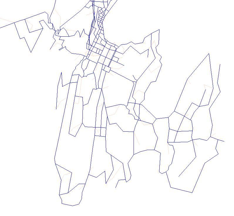
Figure 4-1 below display the difference between the 2006 and 2011 networks for Wellington
City and the additional links and definition included in the model. A similar exercise
occurred throughout the region.
2006 2011
Figure 4-1 : 2006 and 2011 Network Coding for WTSM and WPTM
Further Documentation: Ref TN1 Network Preparation and TN15 Input Parameters
14Model Development Report
4.2 WTSM Base Model Calibration and Sensitivity Testing
WTSM Calibration - A number of key themes developed early in the model update process
that affected how the project proceeded and the type of analysis undertaken. The following
issues presented the team with the following opportunities and challenges:
• New networks and services;
• Estimated land-use (and cancellation of the 2011 NZ Census);
• Economic recession and government policy changes;
• Disruption to data collection programmes;
• Better public transport data availability;
• New PT assignment module in EMME software; and
• Undocumented model run macros and updates to macros.
The team met these challenges through a series of thorough investigations which benefited
substantially from involvement of the peer reviewer via weekly update meetings. Those
investigations included:
• Trip generation & aggregate demand;
• HCV demand re-estimation;
• Network and matrix model convergence;
• Mode choice model adjustments;
• Assignment routing issues; and
• Testing and implementation of new Transit Assignment EMME Module.
Testing of Model Parameters – TN15 documents the tests undertaken to assess the impact
of various changes to input parameters on percentage trip increases between 2011 and
2021. The tests were as follows:
• Test 1: PT fares increased by 10% by 2021;
• Test 2: PT fares increased by 10% and Vehicle Operating Costs increased by 29%;
• Test 3: PT fares increased by 10%, Vehicle Operating Costs increased by 29%; and
Parking increased by 23%; and
• Test 4: PT fares increased by 10%, Vehicle Operating Costs increased by 29%,
Parking increased by 23%, and Value of Time increased by 23%.
WTSM Sensitivity Testing – TN18 documents the tests that were run to establish whether
the overall sensitivity of the model to changes in network level-of-service is reasonable.
These tests were:
• Public transport fares: +20% changes in all PT fares;
• Public transport in-vehicle times: +20% changes in all PT times;
• Public transport frequencies: +20% changes for all PT;
• Car operating costs or fuel costs: +20%; and
• Car in-vehicle times: +20%.
For information the following additional tests were completed:
• CBD parking charges: 100% increase on average CBD charges; and
• CBD pricing cordon: $2 peak, $1 off peak.
15Model Development Report
Further Documentation: Ref TN15 Input Parameters and TN18 WTSM Calibration and
Validation.
4.3 Airport Model Calibration
Survey of vehicle movements entering and exiting the Airport was undertaken on Tuesday
4th October 2011 as outlined in TN8. Data was collected across all three peak periods and,
in conjunction with flight passenger information, was used to form the basis of the
calibration of the airport model.
Analysis of the survey data allowed modal capability to be updated from that within the
2006 model, which only accounted for car trips to and from the airport. Two key changes
with respect to modal choice in the airport model are as follows:
• Market segmentation has been abandoned. The purpose of this segmentation in the
2006 model had been to determine alternative mode preference arrangements for
different market segments. However, as these segments have not been based on any
sort of survey data it is difficult to support the approach i.e. it adds complexity to the
model but is not supported by any verifiable data.
• Mode choice, which had previously been fixed, has been converted into a logit model
with ‘park-and-fly’, ‘drop-off / pick-up’, taxi and car hire being rolled up into ‘car’. While
the logit model is not particularly sophisticated it does succeed in meeting the goals of
introducing a mode response for airport passenger related demand.
Time of day period conversion factors were developed using a combination of airport
passenger arrival and departure information for initial factors which were then calibrated to
match the observed traffic data.
As discussed in TN9 (to remain in draft form and not part of the core model documentation)
there were a number of options recommended in the literature regarding mode choice
model forms. The most common included nested logit, multinomial logit and binomial
models. The first two require significantly more data concerning both market segmentation
and mode choice preferences than what was available for this study. The approach
therefore was to adopt a relatively simple synthetic binomial choice model for a single
market segment: air passengers.
It also became apparent during model calibration that the importation of constants and
parameters from other models was not going to be appropriate. This was due to differences
in characteristics of the Wellington International Airport and its proximity to demand sources
e.g. a large part of the demand comes from the Wellington CBD where the choice is more
car versus taxi.
A possible improvement to the airport model could be to develop a hierarchical mode
choice model where the first decision point is car versus bus and a second tier which splits
the car trips across taxi, park and fly, drop off and hire car.
While this airport model was developed as part of the project, due to timeframes and the
very low PT demands from the Wellington Airport it was decided that the model would not
form part of the validation process or core modelling system at this time.
16Model Development Report
Further Documentation: Ref TN8 Airport Survey Methodology and TN9 Draft Airport Model
WTSM (delivered to GWRC but not part of the core model documentation at this time)
4.4 WTSM Validation
The criteria agreed with the peer reviewer and client has been detailed in TN17.
The WTSM process, being an update only, suggests that in general, the validation will be
carried out against the same criteria and levels as the previous update of the model
undertaken in 2008. WPTM is an entirely new model, with trip demand from observed data
sources. This has some implications for validation, and a method and criteria appropriate to
this type of model is set out in TN17.
As emphasised in the Model Investigation Report, both WTSM and WPTM have been
validated together. The following summarises the approach being taken.
1. Initial Network Development. This task covers the initial development of networks
and PT services from GIS files and GWRC’s Public Transport Database. Basic
model assignment algorithms are developed and unitary matrices are assigned to
the network to check for coding deficiencies. These networks and services form the
basis for both WTSM and WPTM assignment and aside from the different zone
system (and centroid connectors) sizes will remain identical.
2. Initial WTSM Calibration. The purpose of this task is to get WTSM into a reliable
and stable enough state to provide initial data for WPTM development. This step will
provide robust highway travel times for the bus assignments and allow skimming of
the network for development of the access choice model.
3. Initial WPTM Calibration. The purpose of this task (which overlaps with stage 4
described below) is to use the WTSM networks and services (with highway speeds)
in the calibration of PT services and PT related parameters (new walk connectors
may also be added).
4. WTSM – WPTM Validation Iteration. This stage involve iterating between the
WTSM and WPTM calibration i.e. any changes in the following elements will be
brought back into WTSM to maintain consistency between the models*:
• Networks e.g. walk links;
• PT services e.g. if services are disaggregated; and
• PT assignment parameters.
TN18 describes the calibration and validation procedures carried out on the 2011 WTSM
model update and covers:
• Vehicle screenline validation process - Validation of vehicle trips has been carried
out in a similar method to that used for the 2006 WTSM validation such that
comparison can be made between the two models. Vehicle assignment has been
compared against observed data and 2006 values using GEH statistical values for
*
Any exceptions will be described & documented in TN18
17Model Development Report
private vehicles and HCVs separately. Additionally, individual counts have been
presented as scatterplots for the calculation of the coefficient of determination (R2)
and root mean square error (RMSE).
• Vehicle journey time validation - Journey time surveys carried out on behalf of
NZTA along strategic routes within the Wellington region across the AM, IP and PM
periods have been utilised. Summary tables comparing observed averages against
modelled times are presented in the main body of TN18 along with notes with further
explanation.
• Bus passenger count validation - Observed values were sourced from the WPTM
bus assignment which assigned observed ETM records. Validation of bus patronage
has been carried out in a similar method to vehicle screenline validation. They differ in
terms of the period reported (data was only collected for AM and IP periods) and in
the measures they assessed against (GEH is combined with % difference in line with
international best practice).
• Rail count validation - Observed values were obtained from rail counts at the end of
2011. Rail count validation was been reported as a comparison of observed and
modelled cumulative loading profiles down the Kapiti and Hutt lines for the AM and IP
peak periods.
• Demand and assignment model convergence - Demand model convergence has
been measured by calculating the RMSE for each final demand matrix (car and public
transport for each period - i.e. 6 matrices). Highway assignment convergence has
been measured using relative gaps of total vehicle kilometres and vehicle minutes
travelled between successive updates of intersection capacities during the highway
assignment.
• Sensitivity tests - Tests were run to establish whether the overall sensitivity of the
model to changes in network level-of-service are reasonable. These tests included
changes to public transport fares, public transport in-vehicle times, public transport
frequencies, car operating costs or fuel costs, car in-vehicle times and CBD parking
charges.
The 2011 model update process concluded with a model that achieved validation goals
and, as such, is considered suitable for the purpose of policy studies, strategy studies,
corridors studies and providing demand to project models in the Wellington Region.
However, as with any strategic model, local area validation may be required if it is to be
used for project studies where WTSM is the sole source of economic evaluation data.
The key WTSM validation outcomes resulted in the following:
• Highway validation similar to the 2006 model and better than the 2001 model; and
• Rail and bus validation better than 2006 due to the significant data collection exercise
for WPTM and the improvements to the model (especially in the AM peak).
Further Documentation: Ref TN17 Validation Guidelines and Criteria – WTSM and WPTM
and TN18 WTSM Calibration and Validation
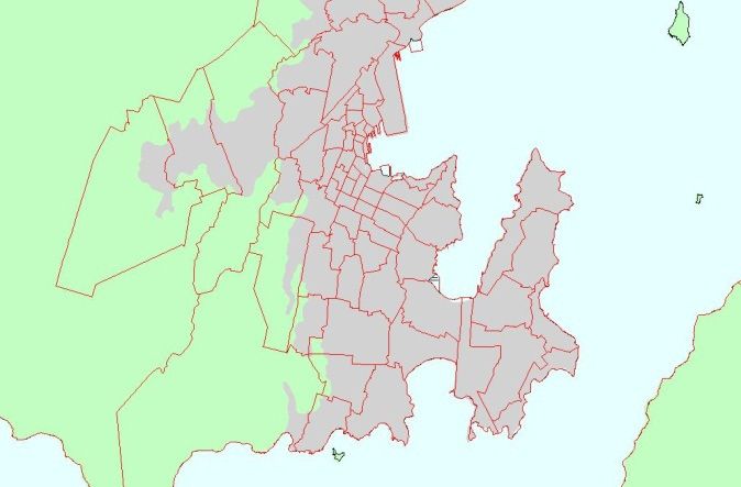
4.5 WPTM Base Model Development
As part of the project, the team reviewed the proposed 780 zone system and determined
that this would be implemented for WPTM, this significant increase in zone definition is
displayed in Figure 4-2 below which presents the difference between the 228 zones
definition in WTSM and the 780 zones definition in WPTM for the Wellington area. The
18Model Development Report
increased zone definition has allowed for better representation of bus stop and rail station
access and locations. The zone disaggregation process and the growth demand forecasting
between WTSM and WPTM has been documented in TN20.
WTSM WPTM
Figure 4-2: WTSM and WPTM Zone System
There were four options considered for the model structure of WPTM and discussed in
detail in TN6. Option 4 was selected as the preferred method for WPTM. It is simple and
takes advantage of the relative strengths of the two approaches – an assignment model to
allocate demand to modes and routes, and logit models for access choice that is unsuited
to assignment (access choices being influenced by non-modelled personal circumstances
as much as the travel times and costs).
Mode-specific preferences of bus, rail and other modes will be captured in the assignment
model through use of variable weights applied to in-vehicle time, boarding or wait time.
Some different assignment methods were trialled in EMME: standard, optimal strategies
and strategies with variants. It was decided to use the strategies with variants, as this
method closely replicates the results of the other two assignment methods, while giving
more flexibility in options. Details on this topic are provided in TN19.
A key feature of WPTM is that demand matrices are developed from observed data, rather
than being synthesised by the model. This ensures that demand is as accurate as it
reasonably can be (modelling errors being minimised), and making WPTM particularly well
suited for application to corridor projects, operational studies and projects in the later stages
of design.
Further Documentation: Ref TN6 WPTM Specification and TN19 WPTM Calibration and
Validation
4.6 WPTM Base Model Calibration and Sensitivity Testing
WPTM Calibration - The key results that were checked with each set of new parameters
were the CBD cordon survey, bus vs. rail splits in key corridors, rail boarding and alighting
graphs, and screenlines.
Some of the parameters changes that were trialled to improve the results (but not
necessarily adopted) were:
19You can also read