HORIZON 2020 Coordination and Support Action Grant Agreement No: 652641 - CONNECTING SCIENCE WITH SOCIETY
←
→
Page content transcription
If your browser does not render page correctly, please read the page content below
HORIZON 2020
        Coordination and Support Action
          Grant Agreement No: 652641

       CONNECTING SCIENCE WITH SOCIETY

              Deliverable No. D3.3
Survey of existing use of space assets by European
 polar operators, including recommendations for
              improved coordination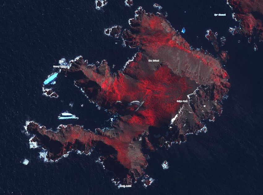
EU_PolarNet – GA 652641 Deliverable D3.3
Submission of Deliverable
Work Package WP3
Deliverable no. & title D 3.3 Survey of existing use of space assets by European polar
operators
Version Final
Creation Date June 2017
Last change 12.07.2017
Status Draft
WP lead accepted
Executive Board accepted
Dissemination level PU-Public
PP- Restricted to programme partners
RE- Restricted to a group specified by the consortium
CO- Confidential, only for members of the consortium
Lead Beneficiary NERC-BAS (partner 3)
Contributors 1 – AWI, 2 – CNRS, 3 - NERC-BAS, 4 - CNR-DTA,
5 – SPRS, 6 – IPEV, 7 - IGOT-UL, 8 – RUG, 9 - RCN,
10 – MINECO, 11 – CSIC, 12 - UW-APRI, 13 – BAI,
14 – GEUS, 15 – VUB, 16 – UOULU, 17 – RBINS,
18 - IGF PAS, 19 - IG-TUT, 20 – AMAP, 21 – WOC,
22 - GINR
Due date 28.02.2017
Delivery date 12.07.2017
© EU-PolarNet Consortium 12/07/2017
Page 2 of 42
EU_PolarNet – GA 652641                                                                                             Deliverable D3.3

                                                  TABLE OF CONTENTS
1.    INTRODUCTION ............................................................................................................ 6
     1.1.     Document Overview and Scope ................................................................................ 6
     1.2.     Layout of the Document ............................................................................................ 7
     1.3.     Reference Documents ............................................................................................... 7
     1.4.     Acronyms ................................................................................................................... 7
2.    POLAR CONTEXT AND STRATEGIC IMPORTANCE ......................................................... 9
3.    CATEGORIES OF SPACE ASSETS .................................................................................. 10
     3.1.  Satellite communications ........................................................................................ 10
         Geostationary satellite systems .................................................................................. 10
         Low and medium earth orbit systems ........................................................................ 11
     3.2. Satellite navigation .................................................................................................. 12
     3.3. Earth observation satellite imaging ......................................................................... 13
     3.4. Other space technologies for polar operators ........................................................ 14
4.    USE OF SATELLITE COMMUNICATIONS FOR POLAR OPERATIONS ............................ 14
     4.1.     Science data ............................................................................................................. 15
     4.2.     Field party safety ..................................................................................................... 16
     4.3.     Satellite data relay ................................................................................................... 17
     4.4.     Shipping and maritime ............................................................................................. 18
     4.5.     Aeronautical ............................................................................................................. 19
     4.6.     Search and rescue (SAR) .......................................................................................... 20
     4.7.     Remote polar stations and temporary field camps ................................................. 23
     4.8.     Emergency telemedicine ......................................................................................... 24
5.    USE OF SATELLITE NAVIGATION FOR POLAR OPERATIONS ....................................... 24
     5.1.     General navigation and position.............................................................................. 24
     5.2.     Timing informaton ................................................................................................... 25
     5.3.     Sensor data for EO validation .................................................................................. 25
     5.4.     GNSS reflectometry ................................................................................................. 26
6.    USE OF SATELLITE REMOTE SENSING IN OPERATIONAL ACTIVITIES.......................... 26
     6.1.     Environmental impact assessment .......................................................................... 26
     6.2.     Monitoring human impact ....................................................................................... 26
     6.3.     Engineering design - siting buildings & offshore infrastructure ............................. 27
     6.4.     Overland travel ........................................................................................................ 30
     6.5.     Ship navigation and operations ............................................................................... 31
     6.6.     Risk management .................................................................................................... 31
     6.7.     Emergency response ................................................................................................ 34
     6.8.     Weather forecasting – reliant on regular satellite imagery and data ..................... 35
     6.9.     Climate change adaptation ...................................................................................... 35
7.    USE OF OTHER SPACE TECHNOLOGIES....................................................................... 35
© EU-PolarNet Consortium                                                                                                   12/07/2017

Page 3 of 42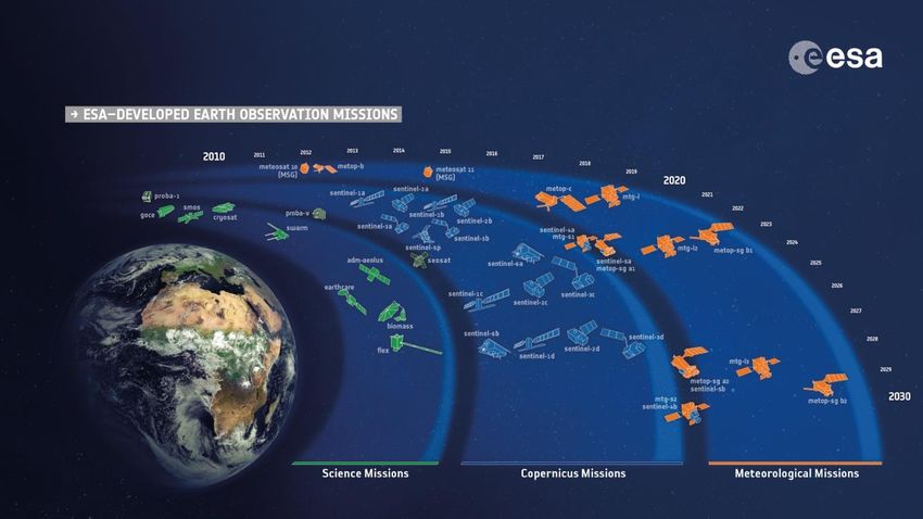
EU_PolarNet – GA 652641                                                                                                 Deliverable D3.3

     7.1.      SatAIS ....................................................................................................................... 35
     7.2.      ADS-B ....................................................................................................................... 36
     7.3.      GNSS Augmentation ................................................................................................ 36
     7.4.      Integrated Applications ........................................................................................... 37
8.     SPACE ASSETS AND THE EUROPEAN SPACE PROGRAM ............................................. 37
     8.1.      Overview of European space programme ............................................................... 37
     8.2.      ESA Space Segment.................................................................................................. 38
     8.3.      EU Space Program.................................................................................................... 38
     8.4.      Improving coordination for developing future space assets ................................... 40
9.     CONCLUSIONS ............................................................................................................ 42

                                                         LIST OF TABLES
Table 1: Deliverables from EU-PolarNet Task 3.2 ..................................................................... 6
Table 2: List of publications referenced Deliverable D3.3 ........................................................ 7
Table 3: List of acronyms used in this document. ..................................................................... 7
Table 4: Drives for investment in space infrastructure. .......................................................... 10

                                                        LIST OF FIGURES
Figure 1: Summary of the qualitative estimates of the cost to develop high-priority
   technologies, including new satellite missions (taken from COMNAP Antarctic Roadmap
   Challenges report). ............................................................................................................... 9
Figure 2: Coverage of Inmarsat Global Xpress footprints extending to the edges of both polar
   regions. ............................................................................................................................... 11
Figure 3: Depiction of an Iridium Next satellite. ..................................................................... 12
Figure 4: Depiction of a Galileo GNSS satellite in orbit. .......................................................... 13
Figure 5: Copernicus series of Sentinel satellites. ................................................................... 14
Figure 6: Collection of data from instrumentation by the ARGOS satellite system. .............. 16
Figure 7: Handheld Garmin InReach units which provide satellite communication and position
   functions. ............................................................................................................................ 17
Figure 8: Depiction of the EDRS data relay satellite capability. .............................................. 18
Figure 9: Summary graphic of IMO Polar Code requirements for ships operating in polar
   waters. ................................................................................................................................ 19
Figure 10: Diagrammatic of a simulated common operating picture in a SAR event taken from
   the ESA ArcticSat study....................................................................................................... 21
Figure 11: Diagrammatic of the COSPAS-SARSAT system (courtesy of NASA). ...................... 22
Figure 12: Diagrammatic of Inmarsat coverage, showing limited coverage of sea area 4 (the
   polar regions). ..................................................................................................................... 23
Figure 13:.Ship navigation through sea ice in the Weddell Sea. Sea ice conditions are visible in
   both satellite radar imagery (from Sentinel1) and sea ice concentration data (from
   University of Bremen)......................................................................................................... 25
© EU-PolarNet Consortium                                                                                                      12/07/2017

Page 4 of 42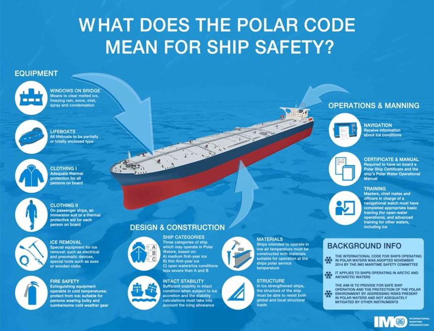
EU_PolarNet – GA 652641                                                                                               Deliverable D3.3

Figure 14: High resolution satellite imagery used to monitor vegetation cover on Moe Island
   ASPA.................................................................................................................................... 27
Figure 15: DEM of part of the Antarctic Brunt Ice Shelf used for site selection when relocating
   the UK Halley VI Research Station. ..................................................................................... 29
Figure 16: Coverage of the ArcticDEM elevation dataset. ...................................................... 29
Figure 17: A Digital Globe WorldView2 optical satellite image of Dorrel Rock (near Mt Murphy,
   Antarctica), clearly showing areas of significant crevassing which makes the area very
   dangerous for overland travel. ........................................................................................... 30
Figure 18: An ice chart of the Southern Ocean (top) includes information about the sea ice
   concentration and stage of development. The POLARIS system translates this into a risk
   map (bottom) showing areas where the ship can operate (green), proceed with caution
   (amber) and cannot operate (red). .................................................................................... 32
Figure 19: Open lead in Exploits River ice cover (top) and map of change detection in the
   Exploits River derived from satellite synthetic aperture radar imagery. ........................... 33
Figure 20: Showing sea ice conditions from MODIS satellite imagery (provided by NASA) and
   the position of the Akademik Shokalskiy and other vessels responding to the incident. . 34
Figure 21: AIS data in green and Sat-AIS data in yellow provided courtesy of the Norwegian
   AISSAT-1 9satellite (Kongsberg Seatex AS). ........................................................................ 36
Figure 22: EO missions developed by ESA............................................................................... 38
Figure 23: Sea ice thickness derived from Cryosat2 data. Provided courtesy of CPOM. ....... 39

© EU-PolarNet Consortium                                                                                                     12/07/2017

Page 5 of 42
EU_PolarNet – GA 652641                                                           Deliverable D3.3

1. INTRODUCTION
    1.1.         Document Overview and Scope
This report (D3.3) is a component of EU-PolarNet work package 3 which encompasses
Infrastructures, Facilities and Data. The task objective is to consider joint programming of
infrastructure to enable bigger and more complex science projects.
Task 3.2 considers space technologies as part of the facilities, infrastructure and operations of
European nations in the polar regions. The aim is to determine the best approach to wider
and more coordinated use of space-based assets and facilities to support polar infrastructure
and operations in delivering polar science.
We note that in the context of this task, support to polar operations is considered distinct
from the direct use of space assets and data in polar science. Direct use of science data derived
from space infrastructure is considered separately as part of the wider consideration of polar
science and related data requirements. What is considered here are the space technologies
which form part of the infrastructure and logistical support necessary to enable the scientific
community to conduct the research.
Task 3.2 provides two formal deliverables as described in the EU PolarNet project proposal.
Table 1: Deliverables from EU-PolarNet Task 3.2

    Task 3.2 Satellites, communication and remote sensing
    D3.3 Survey of existing use of space assets by European polar operators, including
         recommendations for improved coordination
    D3.6 Gap analysis highlighting the technical and operational requirements of the European
         Polar Research Programme for satellite applications and identifying opportunities for
         improved linkages to ESA and other space agencies

In summary this report has the following aims:
•       Summarise the current use of space assets to support polar operations by European
        polar programmes, highlighting the unique role of space technology for the polar
        regions.
•       Identify space facilities and services which polar operators are reliant on.
•       Address how to improve coordination of stakeholders in the European space program,
        including Galileo, Copernicus and the European Space Agency.
•       Recommend approaches for wider and more coordinated access to space assets to
        support polar infrastructure and operations.
We also note that this report is not intended to exhaustively list every instance of use of space
technologies in the context of polar operations. The intent is to summarise the main areas of
use and provide some illustrative examples. This will set the scene for the next step, to identify
gaps in current capabilities.
This report does not address the costs of space technologies being used and is not able to
comment on their cost effectiveness. This would require a complete end-to-end cost benefit
analysis which is not within the scope of this task.
© EU-PolarNet Consortium                                                              12/07/2017

Page 6 of 42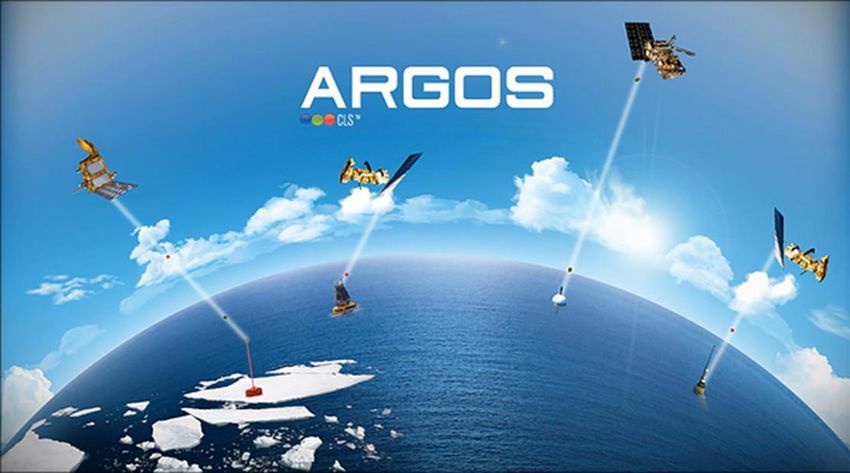
EU_PolarNet – GA 652641                                                             Deliverable D3.3

The second deliverable (D3.6) will focus on highlighting the gaps in current space
infrastructure and aim to set out a coordinated statement of requirements from the polar
community. It will also present anticipated advances and future trends in space technologies
that may have new application in the polar regions. This information will feed into the future
evolution and implementation of the European space program and provide guidance to other
stakeholders and providers of space infrastructure.
      1.2.        Layout of the Document
The document contains the following sections.
Section 1: Introduction, context and related information.
Section 2: Overview of polar context and its strategic importance.
Section 3: Summary of the various space assets discussed in the document.
Section 4: Description of the use of satellite communications in polar operations.
Section 5: Description of the use of satellite navigation in polar operations.
Section 6: Description of the use of satellite remote sensing in polar operations.
Section 7: Description of the use of other space technologies in polar operations.
Section 8: Summary of the facets of the current European space program and includes
recommendations for improved coordination.
Section 9: Main conclusions at this stage of the task.
      1.3.        Reference Documents
Table 2: List of publications referenced Deliverable D3.3

 EU Joint Communication “An http://eeas.europa.eu/archives/docs/arctic_region/docs/1604
 integrated European Union 27_joint-communication-an-integrated-european-union-policy-
 policy for the Arctic”     for-the-arctic_en.pdf
                                        http://www.arcticobserving.org/images/pdf/Board_meetings/
 ESA Polaris Study
                                        2016_Fairbanks/14_Final-Summary-Report_2016-04-22.pdf
 Arctic Council Task Force -
                                 https://oaarchive.arctic-
 Telecommunications
                                 council.org/bitstream/handle/11374/1924/2017-04-28-
 infrastructure in the Arctic: a
                                 ACS_Telecoms_REPORT_WEB-2.pdf?sequence=1
 circumpolar assessment
 COMNAP Antarctic Roadmap https://www.comnap.aq/Projects/SiteAssets/SitePages/ARC/A
 Challenges report        ntarctic_Roadmap_Challenges_Book_2016.pdf

      1.4.        Acronyms
Table 3: List of acronyms used in this document.

 ADS-B                          Automatic Dependent Surveillance – Broadcast
 AIS                            Automatic Identification System
 ASPA                           Antarctic Specially Protected Area
 COMNAP                         Council of Managers of National Antarctic Programs
                                Cosmicheskaya Sistyema Poiska Avariynich Sudov - Search and Rescue
 COSPAS-SARSAT
                                Satellite-Aided Tracking
 EC                             European Commission

© EU-PolarNet Consortium                                                                12/07/2017

Page 7 of 42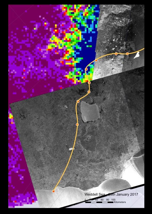
EU_PolarNet – GA 652641                                                          Deliverable D3.3

 EGNOS                     European Geostationary Navigation Overlay Service
 EGSA                      European Global Navigation Satellite Systems Agency
 EO                        Earth Observation
 EPIRB                     Emergency Position-Indicating Radio Beacon
 ESA                       European Space Agency
 EU                        European Union
 GCOS                      Global Climate Observing System
 GNSS                      Global Navigation Satellite System
 GPS                       Global Positioning System
 ICAO                      International Civil Aviation Organization
 IMO                       International Maritime Organisation
 JCB                       Joint Board on Communication Satellite Programme
 NWP                       Numerical weather prediction
 PB-EO                     Programme Board for Earth Observation
 PB-NAV                    Programme Board on Satellite Navigation
 POLARIS                   Polar Operational Limit Assessment Risk Indexing System
 RCC                       Rescue Coordination Center
 S-AIS                     Satellite Automatic Identification System
 SBAS                      Space Based Augmentation Systems
 SAR                       Search and Rescue
 SART                      Search and Rescue Transponder

© EU-PolarNet Consortium                                                             12/07/2017

Page 8 of 42
EU_PolarNet – GA 652641                                                                      Deliverable D3.3

2. POLAR CONTEXT AND STRATEGIC IMPORTANCE
The focus of this report is the use of space technologies in support of European polar programs
and operations. As noted in the COMNAP Antarctic Roadmap, the emergence of space-based
technologies over the last six decades is a key technology enhancement which supports
operations to enable science. The COMNAP ARC report went as far as to identify “new and
improved satellite sensors, including appropriate coverage and availability” as one of the
major cross cutting technology requirements for the Antarctic (see also Figure 1).
However, space technologies are expensive long term investments, funded by both the public
and private sector to satisfy wide ranging public good, societal, policy and commercial needs.
Space infrastructure is not exclusively dedicated to polar operations and it is worth
understanding the context for justifying these investments. This is especially important when
considering gaps in current capabilities and how they might be filled.
The polar regions are important for many reasons.
    • They affect the entire planet due to their role in regulating and driving the global
       climate.
    • They are experiencing significant change.
    • There is growing global interest both politically and economically.
    • New economic opportunities are driving increased attention and traffic.
    • There is widespread public concern about the delicate and pristine environment.
For these reasons, it is vital to develop tools to model, understand and monitor the polar
regions to better predict and mitigate the resulting global economic and environmental
consequences. These models and monitoring strategies increasingly rely on data derived from
and delivered by space infrastructure.

Figure 1: Summary of the qualitative estimates of the cost to develop high-priority technologies, including new
              satellite missions (taken from COMNAP Antarctic Roadmap Challenges report).

© EU-PolarNet Consortium                                                                          12/07/2017

Page 9 of 42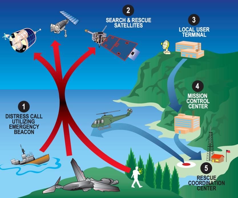
EU_PolarNet – GA 652641                                                               Deliverable D3.3

When considering the providers of these space infrastructure, it is acknowledged that
supporting polar operations is one part of a very wide set of requirements. Understanding the
basis for reliance on these infrastructures requires awareness of this wider setting. As
highlighted by the COMNAP ARC report, development of satellite technologies and sensors is
expected to occur outside of the Antarctic community.
This is not the place for a detailed analysis of the justification and drivers for all space assets
mentioned in this report, but a short list of relevant factors is provided below (Table 4) for
information.
Table 4: Drives for investment in space infrastructure.

                                           Information and data is required to develop local and
 Policy support                            national government policies. Monitoring is also required
                                           to scrutinize policy implementation and effectiveness.
                                           Space infrastructure underpins commercial services
 Commercial activity                       which can justify private sector investment in space
                                           infrastructure.
                                           Open access to space data and infrastructure is
 Economic development                      considered a driver of new innovative services and
                                           applications which will support economic growth.
                                           Data and observations from space are frequently part of
 Science research                          national, European and international research projects.
                                           Open access to infrastructure such as satellite navigation
 Societal needs                            systems and weather satellites provide benefits to the
                                           public.

3. CATEGORIES OF SPACE ASSETS

    3.1.          Satellite communications
Satellite communications refer to in orbit assets which provide voice and data radio
communications capabilities via satellite transponders. They support communications links
independent of ground infrastructure and are therefore well placed to provide
telecommunications in the polar regions where populations and associated infrastructure
density is low.
Geostationary satellite systems
Geostationary satellites are deployed to an orbit with an altitude of approximately 36,000km
above the equator. This orbit means they remain in a fixed position over the Earth’s surface
as it rotates. At latitudes greater than 70 degrees (north and south), the very low incidence
angle from the ground to the satellite means connectivity to the satellite becomes patchy or
impossible due to the curvature of the Earth. As a result, geostationary telecommunications
services are useable in the Arctic or Antarctic, but only to users at relatively low latitudes.
Where they are available, they provide broadband services over wide areas without the need
for fixed infrastructure.
© EU-PolarNet Consortium                                                                   12/07/2017

Page 10 of 42
EU_PolarNet – GA 652641 Deliverable D3.3
Example: Inmarsat Global Express
The Inmarsat Global Xpress satellite network comprises four Ka-band, high-speed mobile
broadband communications satellites (see Figure 2 for their footprint). The network delivers VSAT
services to maritime, aeronautical and users in other sectors. The satellites have a combination of
fixed narrow spot beams that enable Inmarsat to deliver higher speeds through more compact
terminals, plus steerable beams so additional capacity can be directed in real-time to where it is
needed.
Figure 2: Coverage of Inmarsat Global Xpress footprints extending to the edges of both polar regions.
Further information is available at http://www.inmarsat.com/service/global-xpress/.
Low and medium earth orbit systems
At higher-latitudes, low and medium-earth orbit satellite services provide voice and data
capabilities. Since the orbits of these satellites cross the poles, they are well placed to provide
the necessary coverage. Currently the primary provider of these mobile satellite services is
Iridium.
In the future, there are plans for new communication satellite networks to be deployed
consisting of hundreds of satellites providing global coverage including the polar regions.
OneWeb plans a constellation of up to 648 low-Earth Orbit (LEO) satellites, beginning with
launches in late 2017. OneWeb is also expected to have the first satellites to enable high
throughput broadband at higher latitudes.
© EU-PolarNet Consortium 12/07/2017
Page 11 of 42EU_PolarNet – GA 652641 Deliverable D3.3
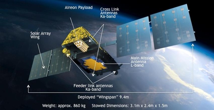
Example: Iridium Next
Iridium Next (see Figure 3) is the replacement for the current constellation of Iridium
communication satellites. The network will consist of 66 satellites, plus in orbit and on ground
spares. Data rates up to 128kb/s are currently available, increasing to 512kb/s when the full
constellation is ready in 2018. Support for legacy phones and devices will continue at data rates of
the first-generation satellites. In addition, the Iridium Next satellites will include the AIREON
payload providing ADS-B air traffic surveillance services.
Figure 3: Depiction of an Iridium Next satellite.
Further information is available at https://www.iridium.com/network/iridiumnext.
3.2. Satellite navigation
Global Navigation Satellite Services (GNSS) use satellites to enable earth receivers to
determine their location to a high level of precision (within metres or centimetres). GNSS
receivers are found in a very large range of equipment from personnel and wildlife trackers to
ships and aircraft. In the polar regions, there are some limitations on the accuracy of position
information due to ionospheric effects, but they still have wide application as the best option
for providing position information to support safe navigation and providing accurate timing
information.
Currently two GNSS systems are operational:
U.S. Global Positioning System (GPS)
Russia’s GLONASS system
In addition, two systems are currently under development:
European Union’s Galileo system (full operations planned for 2019)
Chinese BeiDou Navigation Satellite System (full operations planned for 2020)
© EU-PolarNet Consortium 12/07/2017
Page 12 of 42EU_PolarNet – GA 652641 Deliverable D3.3
Example: European Galileo System
The European Galileo GNSS network will consist of 30 satellites in orbit (Figure 4) and is scheduled
to be fully operational in 2020. The system will provide several levels of service including open
access and a higher-precision encrypted commercial service. The inclination of the orbits was
designed to ensure good coverage at polar latitudes, which are poorly served by the GPS network.
Galileo is autonomous but also interoperable with existing GNSS systems. The satellites will also
carry MESOSAR transponders providing a new search and rescue capability as an upgrade of the
global Cospas-Sarsat system.
Figure 4: Depiction of a Galileo GNSS satellite in orbit.
Further information is available at http://ec.europa.eu/growth/sectors/space/galileo.
3.3. Earth observation satellite imaging
Earth observation or remote sensing satellites are designed to carry instruments which collect
data about the Earth surface and atmosphere. This information is generally used for purposes
such as meteorology, environmental monitoring and surveying, but the range of applications
for these data is very extensive.
Remote sensing satellites have a unique capability in the polar regions, being the only source
of integrated, year-round, synoptic region-wide measurements of many types of data. Due to
the harsh environment, vast areas and polar winter, collection of data would otherwise be
prohibitively expensive or logistically impossible.
Satellite remote sensing will continue to expand with new sensors and improved coverage.
Satellites are provided by government and commercial operators, with a range of access
options from free and open to fully commercial models.
© EU-PolarNet Consortium 12/07/2017
Page 13 of 42EU_PolarNet – GA 652641 Deliverable D3.3
Example: European Copernicus System
The European Sentinel satellites (Figure 5) form the space segment of the European Copernicus
information services. In combination with in situ measurements and models, they will deliver up
to date global information. The Sentinel series provide a range of different observations and
measurements as described below. The satellites are considered operational and continuity of the
satellite series is planned for years to come.
Figure 5: Copernicus series of Sentinel satellites.
Further information is available at http://ec.europa.eu/growth/sectors/space/copernicus.
3.4. Other space technologies for polar operators
Several other space assets, technologies and activities related to polar operations are worth
consideration. Some relate to extensions of the main assets listed in this section, while others
are related applications which are worth noting. A list is provided below and further
description is given in section 7:
Satellite AIS
ADS-B
GNSS augmentation
Integrated space technology applications
4. USE OF SATELLITE COMMUNICATIONS FOR POLAR OPERATIONS
The importance of telecommunications for the polar regions cannot be overstated, supporting
a wide range of activities in communities, science, navigation, emergency response and
economic development.
© EU-PolarNet Consortium 12/07/2017
Page 14 of 42EU_PolarNet – GA 652641 Deliverable D3.3
A wide range of uses within the polar regions means there are multiple drivers for
telecommunications capacity. Beyond direct support for polar operations other drivers
include:
the public and social needs of indigenous peoples and local communities, and
supporting sustainable economic development and global connectivity.
Both requirements are expected to increase with forecasted growth in economic activity,
traffic and population.
No single technology will meet all telecommunications needs in the polar regions, but satellite
telecommunications are an important component to provide connectivity to vast areas with
low population, little infrastructure and few service providers.
Currently, telecommunications capabilities at high latitudes is only possible with limited
technologies, including VHF/HF radio and satellite voice/data services. This is partly due to
severely limited connectivity due to reduced visibility of geostationary satellites at high
latitudes and the lack of terrestrial infrastructure.
The use of satellite telecommunications as part of support to polar operations includes the
uses described below (sections 4.1.-4.8.).
4.1. Science data
Space-based telecommunications are essential for polar science and environmental
monitoring. Due to the limitations of terrestrial communications links, data collection from
remote instrumentation is difficult. This applies equally to transmission of satellite data to
scientists working in remote field locations. Given the ever-increasing volume of data required
from science and environmental monitoring instruments, there is a severe limitation in the
polar regions on this requirement.
Transmission of data from field instrumentation and to remote field works allows:
Transfer and backup of data, minimizing the risk of data loss.
Collection of data from remote instruments, wildlife, buoys, ice floats, and icebergs.
Continual data transfers in real-time from remote locations as inputs to scientific and
NWP computer model activities (e.g. Automatic Weather Stations).
Input to Earth observation satellite calibration and validation activities.
The transmission of satellite data or sharing of other instrument data to scientists conducting
field operations in remote locations allows:
Access to data to inform scientific field programs, including optimal siting of deployed
instrumentation.
Communication with colleagues to adjust plans in light of new circumstances or to
troubleshoot issues with instrument operation.
© EU-PolarNet Consortium 12/07/2017
Page 15 of 42EU_PolarNet – GA 652641 Deliverable D3.3
Example: ARGOS system
The ARGOS system (Figure 6) is a satellite-based system operating since 1978, relaying
environmental and scientific sensor and position data. It is primarily for uses related to
environmental protection, awareness or study and protecting human life. These data are also vital
for calibration and validation activities of satellite instruments.
Figure 6: Collection of data from instrumentation by the ARGOS satellite system.
Further information is available at http://www.argos-system.org/.
4.2. Field party safety
For all personnel conducting fieldwork or other operations in remote locations, reliable
telecommunications provide the following benefits.
Ability to submit regular status and position updates and communicate on all aspects
of planning ongoing fieldwork. This may include adjusting schedules due to unforeseen
events, reporting emergencies and planning rescue of personnel.
Access to emergency telemedicine services (see section 4.8).
Access to information services like weather, sea ice forecasts etc.
© EU-PolarNet Consortium 12/07/2017
Page 16 of 42EU_PolarNet – GA 652641 Deliverable D3.3
Example: Garmin InReach Explorer communications system
The Garmin InReach Explorer (Figure 7) is a handheld unit which supports 2-way text message
communication and sharing/querying of position information. These functions work globally based
on the Iridium satellite network. The system also provides weather forecast information for the
current location and allows triggering of interactive SOS messaging in an emergency.
Figure 7: Handheld Garmin InReach units which provide satellite communication and position functions.
Further information is available at https://explore.garmin.com/en-GB/inreach/.
4.3. Satellite data relay
Satellite observations of the polar regions are vital for many purposes (e.g. environmental
monitoring, meteorological observation, science data). In some cases there is inadequate
downlink capacity to allow all data to be delivered to the satellite ground segment. To alleviate
this bottleneck in-orbit data relay satellites can be employed to transmit data from the
collecting satellite to the ground network via a geostationary communications satellite (See
Figure 8).
© EU-PolarNet Consortium 12/07/2017
Page 17 of 42EU_PolarNet – GA 652641 Deliverable D3.3
Example: European Data Relay Satellite
The European Data Relay System (EDRS) is designed to transmit data between low earth orbiting
satellites and the EDRS payloads in geostationary orbit using innovative laser communication
technology. Composed of a hosted payload on a commercial telecom satellite and a dedicated
satellite in geostationary orbit, EDRS will dramatically increase the speed of data transmission from
satellites in lower orbits to users on the ground.
Figure 8: Depiction of the EDRS data relay satellite capability.
Further information is available at
http://www.esa.int/Our_Activities/Telecommunications_Integrated_Applications/EDRS.
4.4. Shipping and maritime
Ship operations extend to all parts of the polar oceans for significant parts of the year. Some
operations continue even through the polar winter, including science experiments where
research vessels are purposefully beset in sea ice and drift with it.
The availability of telecommunications is essential for maritime safety and situational
awareness. Polar research vessels use geostationary satellite links for telecommunications
needs (email, Internet, phone, and fax). At higher latitudes where geostationary satellites
have limited visibility, operators must switch to Iridium services.
In addition to general communications needs, polar vessels also have other important
requirements as follow:
Access to routing, hydrographic chart, meteorological, and oceanographic information
services for safe and efficient navigation.
Access to sea ice and iceberg information.
© EU-PolarNet Consortium 12/07/2017
Page 18 of 42EU_PolarNet – GA 652641 Deliverable D3.3
Support for the IMO e-navigation strategy to promote safer navigation, including
better ship-to-ship and ship-to-shore data exchange and communication.
Safety information and situational awareness, SAR preparedness (see section 4.6).
Environmental protection and incident management, e.g. oil spill preparedness.
Regulatory and reporting requirements (e.g. IMO Polar Code).
Example: IMO Polar Code
The International Code for Ships Operating in Polar Waters (Polar Code, see Figure 9) supplements
existing IMO regulations such as SOLAS, to increase safety of ships operation in polar waters. Polar
Code addresses many aspects of ship operations, including limitations of communications at high
latitudes together with guidance for working around these restrictions.
Figure 9: Summary graphic of IMO Polar Code requirements for ships operating in polar waters.
Further information is available at
http://www.imo.org/en/MediaCentre/HotTopics/polar/Pages/default.aspx.
4.5. Aeronautical
Aircraft are a vital form of transport for passengers and cargo in all polar operations both in
the Arctic and Antarctic. This covers a range of activities from support to science operations
and some commercial air traffic. Three categories of aeronautical communications use are
highlighted below:
Operational communications for air traffic management. Managed by ICAO and
including communication, navigation, surveillance and air traffic management
(CNS/ATM) systems. These systems include exchange of information related to safety,
navigation, technical, and administrative or legal matters and their updates.
© EU-PolarNet Consortium 12/07/2017
Page 19 of 42EU_PolarNet – GA 652641 Deliverable D3.3
As a complement to terrestrial datalinks (VHF/HF radio), satellite communication (e.g.
via Iridium) will have an important role to play in ATM infrastructure, providing
additional bandwidth plus coverage at sea and in remote areas such as the Arctic and
Antarctic.
A more recent development has seen ADS-B (see section 7.2) receivers on board LEO-
satellites to collect the position of planes in near real-time worldwide.
Communications during SAR and incident response. Aircraft are very likely to be
involved in any incident response with the polar regions, providing vital surveillance
and rescue capabilities. The response to any aeronautical incident is coordinated by
the aeronautical rescue coordination center (ARCC) which covers the incident location.
In both polar regions satellite communications are vital for notification of incidents
and during the response phase due to the limitations of terrestrial links.
Data communications. Although at an early stage, it is possible to interface directly
with data provided by the aircraft or onboard instrumentation via satellite
communications links. This might include flight data information and onboard
instrumentation.
4.6. Search and rescue (SAR)
Telecommunications are vital when operators require urgent response and outside assistance.
This includes SAR events where life and/or infrastructure is at risk (e.g. a ship sinking), but also
environmental protection e.g. pollution prevention and oil spill response.
This is necessary not only to raise the alarm but also to maintain communications with the
body coordinating the rescue. There are likely to be multiple entities involved in SAR
operations and all will need to share information to maintain a common operating picture as
the basis for coordinated decision making.
© EU-PolarNet Consortium 12/07/2017
Page 20 of 42EU_PolarNet – GA 652641 Deliverable D3.3
Example: Common Operating Picture for SAR
The ESA ArcticSat study considered the use of multiple space technologies to respond to a SAR
incident in the Arctic. A view of the components of a Common Operating Picture to support
decision making was developed. As shown below (Figure 10), the simulated event north of
Svalbard involved numerous entities (ships, aircraft, incident command centers), but the satellite
communication link is clearly a vital part of any such system to allow information to be shared
and synchronized between the incident location and the rescue coordination efforts.
Figure 10: Diagrammatic of a simulated common operating picture in a SAR event taken from the ESA
ArcticSat study.
Further information is available at https://artes-apps.esa.int/projects/arcticsat.
The initial notification of an incident is likely to be via voice communication or activation of a
transmitter (e.g. EPIRB, SART or COSPAS-SARSAT transmitter).
© EU-PolarNet Consortium 12/07/2017
Page 21 of 42EU_PolarNet – GA 652641 Deliverable D3.3
Example: COSPAS-SARSAT
COSPAS-SARSAT terminals are radio transmitters activated by persons, aircraft or vessels in
distress. The alert information is then forwarded on to the responsible authority so they can take
appropriate action (see Figure 11 for an overview). The system uses a network of satellites which
provide global coverage, consisting of five satellites in polar low-altitude Earth orbit (LEOSARs),
nine satellites in geostationary Earth orbit (GEOSARs), and over 30 more recent satellites in
medium-altitude Earth orbit (MEOSARs). MEOSAR receivers are located on navigation satellites
including GLONASS, GPS and GALILEO.
Figure 11: Diagrammatic of the COSPAS-SARSAT system (courtesy of NASA).
Further information is available at http://www.cospas-sarsat.int/.
In most polar SAR and incident response scenarios, especially in maritime events, there will
be a reliance on satellite communications. While initial bandwidth requirements are small
(initial notification and messaging), the bandwidth requirements increase during the incident
as more entities are involved and more data is required to maintain an up-to-date common
operating picture. This increase in required bandwidth may be limited by the capabilities of
currently available Iridium data links.
© EU-PolarNet Consortium 12/07/2017
Page 22 of 42EU_PolarNet – GA 652641 Deliverable D3.3
Example: Global Maritime Distress and Safety System
The GMDSS is an international system using terrestrial, ship-radio and satellite systems to notify
authorities in an emergency. The system also alerts vessels near the incident and provides
improved means of locating survivors. Equipment to operate with the GMDSS network is required
on all maritime vessels more than 2,000 tons. The system considers 4 areas of coverage based on
range of shore based radio and Inmarsat satellites (Figure 12), with the polar regions falling into
Sea Area A4. Since Inmarsat cannot be relied on to provide GMDSS at higher latitudes, IMO is
working to expand GMDSS to include Iridium satellites.
Figure 12: Diagrammatic of Inmarsat coverage, showing limited coverage of sea area 4 (the polar regions).
Further information is available at
http://www.imo.org/en/OurWork/Safety/RadioCommunicationsAndSearchAndRescue/Radiocom
munications/Pages/Introduction-history.aspx.
4.7. Remote polar stations and temporary field camps
Communications between remote stations in the polar regions use a combination of
telecommunications methods. These are required to maintain connectivity in the local area of
operations (close to stations and with field parties deployed at greater distances) and global
connectivity to host nations (potentially on the other side of the globe).
Communications links are necessary to:
Plan and execute field operations and travel, including regular situation reports
Relay information and data to/from field parties, including weather information and
updated plans
Communicate in the event of an emergency
© EU-PolarNet Consortium 12/07/2017
Page 23 of 42EU_PolarNet – GA 652641 Deliverable D3.3
Maintain communications with host organisation/company and maintain supply chain
logistics
Local area communications traditionally use HF/VHF radio links, but increasingly also use
satellite phones (e.g. Iridium) for voice and low volume data transmission. Inter-continental
communications now routinely use satellite communications. Most year-round Antarctic
stations are located on the edge of the continent where they retain some visibility of
geostationary satellites.
4.8. Emergency telemedicine
Medical expertise may not be immediately available for workers in remote polar field sites,
on stations or on ships. In the event of an emergency where immediate medical expertise is
required, telemedicine services can deliver critical care.
Modern telemedicine (which uses video and advanced health monitoring systems) is generally
difficult to provide without access to broadband communications. Its use is therefore limited
in many situations currently, but use will expand as communications systems improve.
5. USE OF SATELLITE NAVIGATION FOR POLAR OPERATIONS
The use of GNSS services has wide application in the polar regions where position, navigation
and timing information is required. While the accuracy of position information is affected by
ionospheric variability, there are space based augmentation systems (SBAS) which are
available for parts of the polar regions to improve the accuracy and integrity of GNSS data.
5.1. General navigation and position
Travel in the polar regions, whether overland, by ship or by aircraft, requires navigation
systems. These are especially important where there is little infrastructure, the terrain can be
featureless, weather conditions can lead to very poor visibility, and detailed maps are often
unavailable. In these circumstances, there is an increasing use and reliance on GNSS systems
for navigation and route following.
GNSS equipped vehicles, vessels and aircraft can be used to locate position on satellite images
and available digital maps. Navigation through or over ice is a good example of this, whereby
satellite imagery provides details of ice conditions, and GNSS provides real-time positions to
allow vessels and field parties to navigate through hazardous ice conditions.
Ships may also have a requirement to hold position in circumstances where there is no
mooring option or if they need to hold position close to another ship or platform. This is
possible for ships equipped with dynamic position (DP) capability. Dynamic positioning is a
computer-controlled system to automatically maintain a vessel's position and heading by
using its own propellers and thrusters. The position information for DP systems is derived from
GNSS systems.
GNSS position information is also vital for safety application in the polar regions. Field workers
in remote locations increasingly make use of personnel trackers (e.g. InReach Explorer) or
have access to emergency beacons (e.g. EPIRB) which are triggered in an emergency. The
position information included as part of the tracking service or contained in an emergency
distress signal is often derived from an integrated GNSS receiver.
© EU-PolarNet Consortium 12/07/2017
Page 24 of 42EU_PolarNet – GA 652641 Deliverable D3.3
Example: Ship navigation in sea ice
The ability to accurately plot a ship position in relation to maps or satellite imagery allows for
optimised navigational decisions based on the current conditions. The example below (Figure 13)
shows the planned route for the British Antarctic Survey ship RRS Ernest Shackleton transiting
through sea ice in the southern Weddell Sea. Up to date ship position from onboard GNSS receivers
allow detailed routing decisions based on the near-real-time satellite imagery which shows the
current sea ice conditions.
Figure 13:.Ship navigation through sea ice in the Weddell Sea. Sea ice conditions are visible in both satellite
radar imagery (from Sentinel1) and sea ice concentration data (from University of Bremen).
Further information is available at www.polarview.aq.
5.2. Timing informaton
GNSS systems are principally based on timing information from precise clocks. Increasingly
many modern systems use GNSS timing as an integral method to synchronise their operation.
While the impact in the polar regions may not be immediately apparent, this reliance will
increase as this source of timing information is incorporated into power grids, mobile
communication networks and other sensor networks.
5.3. Sensor data for EO validation
In situ or mobile sensors combined with GNSS receivers allow collection and potentially real-
time feedback of ground information that can be used to validate remotely sensed
information in a satellite image. For example, a field technician equipped with a GNSS locator
© EU-PolarNet Consortium 12/07/2017
Page 25 of 42EU_PolarNet – GA 652641 Deliverable D3.3
can provide information on land and vegetation classes to support supervised classification of
EO imagery.
5.4. GNSS reflectometry
GNSS reflectometry involves making measurements from the reflections from the Earth of
navigation signals from satellite navigation systems. Payloads can be included on EO satellites
to measure reflected GNSS signals. This technique has been used in studies of parameters
including ocean wave motion and wind speed, sea ice, snow cover and soil moisture.
6. USE OF SATELLITE REMOTE SENSING IN OPERATIONAL ACTIVITIES
Data of the polar regions has been collected from satellite for almost 40 years. These
observations play an important role in polar science, but also in supporting polar operations
and infrastructure in many diverse ways.
Current uses of remote sensing are summarised below (sections 6.1. to 6.9.).
6.1. Environmental impact assessment
Environmental impact assessments (EIAs) are a prerequisite to the development of any major
infrastructure project in the polar regions. Such infrastructure might include development of
a new polar research station, runway or harbor.
Regulators consider many factors when assessing the environmental impacts of projects and
information may be required on the following:
physical and meteorological environment
soil, soil productivity and vegetation
wetlands, water quality and quantity
fish, wildlife, and their habitat
species at risk or species of special status and related habitat
heritage resources
traditional land and resource use
human health, aesthetics and noise
A variety of satellite remote sensing instruments can provide data on many of these factors.
6.2. Monitoring human impact
Given the public perception of the polar regions as pristine environments, there is an ongoing
need to monitor the potential impact of human presence and activities. This is specifically
important for specially protected and managed areas (e.g. Antarctic specially protected areas
- see http://www.ats.aq/e/ep_protected.htm).
Long term monitoring of stations and visited areas, especially high-intensity sites, can help
detect and mitigate the effects of human presence including introduction of alien species.
Given the remote location and other difficulties in visiting these locations, using satellite
imagery makes regular monitoring significantly more efficient.
© EU-PolarNet Consortium 12/07/2017
Page 26 of 42EU_PolarNet – GA 652641 Deliverable D3.3
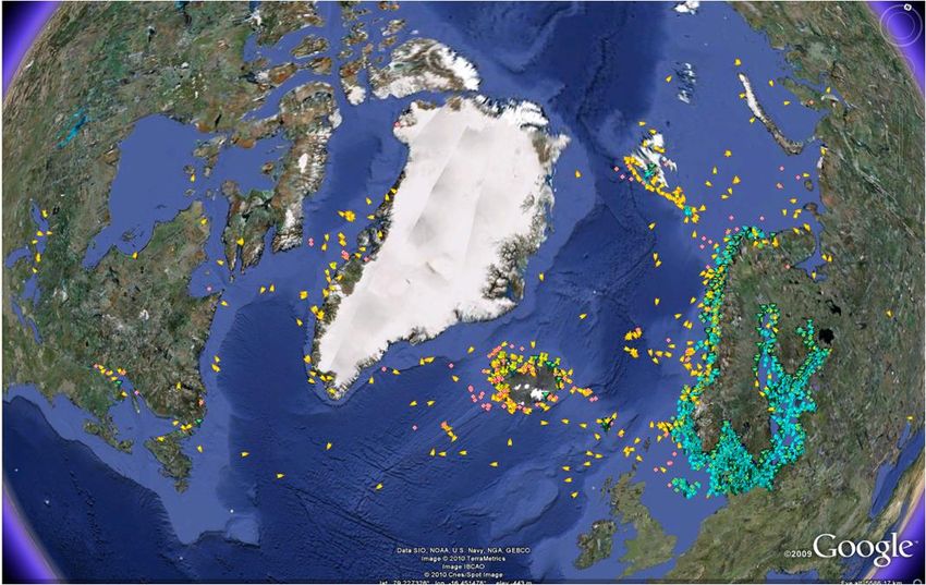
Example: Monitoring ASPA vegetation
One potential impact of human presence is damage to indigenous vegetation and the introduction
of non-native species. High resolution multispectral satellite imagery is used to establish a baseline
of vegetation extent and monitor for changes. The future availability of hyperspectral satellite data
should allow for more detailed surveys of vegetation types to be performed. Moe Island, shown
below (Figure 14), is one of 39 protected areas in the Antarctic which are regularly monitored for
changes in vegetation cover.
Figure 14: High resolution satellite imagery used to monitor vegetation cover on Moe Island ASPA.
Further information is available at http://www.ats.aq/e/ep_protected.htm.
6.3. Engineering design - siting buildings & offshore infrastructure
The design of ships, stations and other facilities for the polar regions must consider the unique
environmental characteristics and challenges of operations in the Arctic and Antarctica.
Designers and architects need information about factors such as weather, temperature,
permafrost, surface topography, sea ice and icebergs. Statistics on many of these parameters
can be derived from satellite data, e.g. wind speed from meteorological satellites, wave height
from satellite altimeter data, iceberg occurrence frequency and size distribution from
synthetic aperture radar imagery.
Siting of science instruments and experiments also requires detailed information about
surface conditions and options for power generation before selecting a suitable site. Relevant
© EU-PolarNet Consortium 12/07/2017
Page 27 of 42EU_PolarNet – GA 652641 Deliverable D3.3 factors include surface slope and aspect, prevailing wind direction and speed, cloud and temperature records. Satellite imagery also provides regular monitoring of dynamic polar environments where infrastructure is located. Such situations include developing fractures in ice shelves and surface deformation caused by permafrost. © EU-PolarNet Consortium 12/07/2017 Page 28 of 42
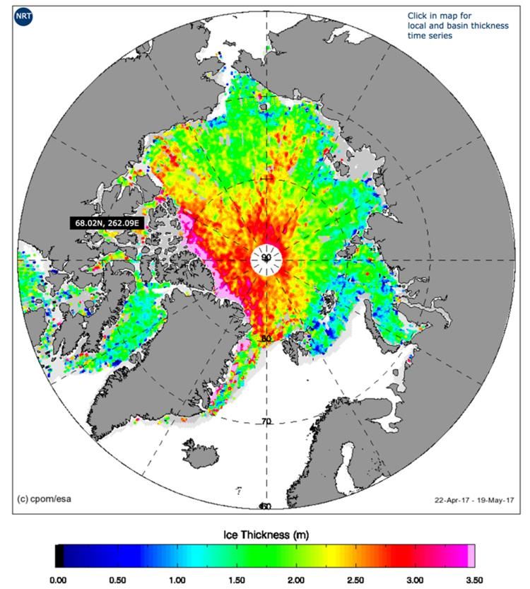
EU_PolarNet – GA 652641                                                                       Deliverable D3.3

                     Example: Elevation data for infrastructure site planning
 Surface elevation and slope for infrastructure planning require detailed digital elevation models of
 remote locations. The use of photogrammetric methods with high-resolution stereo satellite
 imagery has made routine generation of DEMs (Figure 15) with cell spacing of ~2m possible without
 the need for expensive aircraft operations.

 Figure 15: DEM of part of the Antarctic Brunt Ice Shelf used for site selection when relocating the UK Halley
                                             VI Research Station.

                           Figure 16: Coverage of the ArcticDEM elevation dataset.
 The US Polar Geospatial Center have produced a high quality digital surface model of the Arctic.
 The ArcticDEM dataset (Figure 16) is constructed from in-track, high-resolution imagery acquired
 by the DigitalGlobe constellation of optical imaging satellites.
 Further information is available at https://www.pgc.umn.edu/data/arcticdem/.

© EU-PolarNet Consortium                                                                           12/07/2017

Page 29 of 42
EU_PolarNet – GA 652641 Deliverable D3.3
6.4. Overland travel
Detailed route planning is required for a range of operational activities in the Arctic and
Antarctic, including science and research field operations. Access to field locations can often
be a critical limiting factor to conducting science or other polar operations.
Planning of travel by vehicles on land requires analysis of information about crevassing,
fractures in ice shelves, permafrost conditions and the state of winter roads over frozen lakes
and rivers. Detailed information about historical and forecast weather conditions for the
operational period are also critical factors. Many of these parameters are derived from Earth
observation and meteorological satellites.
Example: Crevasse assessment for overland travel
Crevasses pose significant risks for overland travel on glaciated areas of the Arctic and Antarctic.
Field parties often need to access remote locations via overland routes or land aircraft on
unfamiliar surfaces. In these circumstances assessing the area for crevasses is essential to assess
the level of risk, determine safe areas to work and plan safe travel routes.
High resolution visible and radar satellite imagery (see Figure 17) often allows the surface
expression of crevasses to be identified more clearly than when viewed from ground level. While
not all crevasses are visible due to snow cover, these types of imagery provide an excellent way to
assess areas which would be very dangerous to field parties.
Figure 17: A Digital Globe WorldView2 optical satellite image of Dorrel Rock (near Mt Murphy, Antarctica),
clearly showing areas of significant crevassing which makes the area very dangerous for overland travel.
Further information about Digital Globe satellite imagery is available at www.digitalglobe.com/.
© EU-PolarNet Consortium 12/07/2017
Page 30 of 42You can also read