Habitat Suitability Analysis for Swamp Deer (Rucervus Duvaucelii) Using Geo-Spatial Tools in Dudhwa National Park - Science Publishing Group
←
→
Page content transcription
If your browser does not render page correctly, please read the page content below
American Journal of Remote Sensing
2018; 6(1): 52-58
http://www.sciencepublishinggroup.com/j/ajrs
doi: 10.11648/j.ajrs.20180601.18
ISSN: 2328-5788 (Print); ISSN: 2328-580X (Online)

Habitat Suitability Analysis for Swamp Deer (Rucervus
Duvaucelii) Using Geo-Spatial Tools in Dudhwa National
Park
Suneet Naithani1, Prachee Bedi1, Gopala Areendran2
1
    School of Environment and Natural Resources, Doon University, Dehradun, India
2
    Indira Gandhi Conservation Monitoring Centre, World Wide Fund for Nature, New Delhi, India

Email address:

To cite this article:
Suneet Naithani, Prachee Bedi, Gopala Areendran. Habitat Suitability Analysis for Swamp Deer (Rucervus Duvaucelii) Using Geo-Spatial
Tools in Dudhwa National Park. American Journal of Remote Sensing. Vol. 6, No. 1, 2018, pp. 52-58.
doi: 10.11648/j.ajrs.20180601.18

Received: May 15, 2018; Accepted: May 30, 2018; Published: July 7, 2018

Abstract: Dudhwa National Park (DNP), important conservation areas of India supporting the full range of threatened
faunal and floral species. The Barasingha, swamp deer (Rucervus duvaucelii) considered as vulnerable, one of the flagship
species. The satellite imagery of 1995, 2016 and 2017were used for Habitat Suitability Analysis (HSA) using multi-criteria
analysis. The other primary and secondary data were also incorporated to generate habitat suitability model. Raster imageries
of Landsat 5 and Landsat 8 were used to create various themes (variables) such as forest density, land use land cover,
Normalized Difference Vegetation Index (NDVI), Normalized Difference Water Index (NDWI) along with topographic details.
The result indicates that out of total geographical area approximately 2.000000-2.100000(20-21%) is highly suitable,
1.900000(19%) is appropriate, 1.800000(18%) moderately suitable, 1.700000(17%) less suitable and 1.500000-1.600000(15-
16%) area is least suitable. However, the study strongly advocates that the DNP is suitable landscape and grassland were
noticed as one of the best habitat class for the conservation of swamp deer.
Keywords: Dudhwa National Park (DNP), Swamp Deer, Habitat Suitability Analysis (HAS),
                  Normalized Difference Vegetation Index (NDVI), Normalized Difference Water Index (NDWI)

                                                                       agriculture. The remaining habitat in protected areas is
1. Introduction                                                        threatened by the change in river dynamics, increasing
   Habitat suitability mapping in wildlife management is an            siltation and further degraded by anthropogenic pressures.
issue of global importance for the better management,                  Species are said to be a product of their habitat, and hence,
conservation and protection of valuable species. In Dudhwa             maintenance of appropriate habitat is vital to wildlife
National Park (DNP), Swamp deer is also known as the                   management. A habitat is a place occupied by a specific
Barasingha is a relatively large species of deer, usually seen         population within a community population. Conventional
in herds of 8-20 individual. They are crepuscular and live in          surveys are always significant. Nevertheless, in many cases,
the swampy grassland and floodplains of the Indian                     tiresome fieldwork can be supplemented by Remote Sensing
subcontinent and differ from all other species because antlers         (RS) and Geographical Information System (GIS). Ground
carry more than three times. Swamp deer are mainly grazers             surveys have limitations whereas inaccessible areas with
and listed as vulnerable C1 [1], the protection status is not          accuracy are possible through RS aided by limited ground
secure. Thus, the species is assumed to still be in decline by         survey [2-5]. RS and GIS procedures have been utilised
10% over 24 years mostly due to habitat degradation.                   widely in natural surroundings evaluation for different
   The swamp deer populations are threatened by poaching               wildlife species.
for antlers and meat. They have lost most of their former                 A wildlife habitat suitability map depicts the suitability of
range because wetlands were converted and used for                     vegetation, land and water for a specific wildlife species. To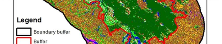
American Journal of Remote Sensing 2018; 6(1): 52-58                                        53

generate a habitat suitability model, species habitat                   of 150 cm. Temperatures range from between a minimum of
information is required for analysis of a species in an                 9°C (48°F) in winter to a maximum of up to 45°C (113°F) in
integrated scientific manner. A quick appraisal of habitat and          peak summer.
identification of potential sites has also been studied by [6].
Likewise, the territory of one-horned rhino (Rhinoceros                 3. Material and Methods
unicornis) was studied [7]. In this study, the objectives were
set to prepare the land-use and land cover map of the DNP                  ERDAS Imagine, Arc GIS, Google earth, topo-sheets and
along with themes of roads, settlement, water bodies with               satellite images (Landsat 1995, 2016 and 1917 were required
their buffer areas and to measure habitat suitability area of           to generate the data set. For generating Land-use/ Land-cover
Swamp Deer. Debeljak [8] has studied the potential                      (LULC), Landsat images were used for unsupervised
territories of a populace of red deer and its impact on the             classification, these classes were recorded into final classes.
environment. GPS location of animal's presence and                         The settlements, road network and water bodies themes
“binomial multiple logistic regression (BMLR)” techniques               with buffer have been created. For preparing Normalized
were integrated into a GIS environment for the HSI                      Difference Vegetation Index (NDVI) and Normalized
modelling [9]. Elephant habitat parameters using GIS,                   Difference Water Index (NDWI) the recent satellite data of
Remote Sensing was also analyzed by Aini et al. [10].                   2016 and 1995 has been used for comparison. Iqbal et al. [11]
                                                                        has also studied the NDVI index in order to monitor
2. Study Area                                                           vegetation cover changes during different time periods. Xu et
                                                                        al. [12] have also studied that NDVI of Landsat 7 and
   The DNP is covering an area of 490.3 km2 lies from                   Landsat 8 is consistent when dealing with high vegetation
28º18’N and 28º42’N latitude to 80º28’E to 80º57’E                      covered areas (e.g. forest area and tall grass prairie) because
longitude. It supports a large number of endangered species.            the difference between Landsat 7 and 8 NDVI is close to zero
The DNP is bordering with Nepal having Mohana River in                  when the value of NDVI is high. A different layer has been
North and river Suheliis in South. The DNP has an extreme               created for NDVI and for NDWI. Al the elements of theme
humid subtropical with dry winters type of climate. Monsoon             were added for final map generation. Finally the weighted
from June to till September accounts for 90% of the rainfall            habitat suitability analysis was done as depicted in Figure 1.

                                  Figure 1. Methodology for Creating Weighted Habitat Suitability Analysis.
54 Suneet Naithani et al.: Habitat Suitability Analysis for Swamp Deer (Rucervus Duvaucelii) Using
Geo-Spatial Tools in Dudhwa National Park
4. Results and Discussion Likewise the NDWI index is most appropriate for water
body mapping. The NDWI can enhance the water
The GIS and RS innovations demonstrated attainable for information effectively in most cases. It is sensitive to built-
the habitat suitability mapping [13]. The LULC map of the up land and often results in over-estimated water bodies.
DNP and the buffer area (10 km) were prepared assigning 47
classses (unsupervised clasification) and finally recoded into NIR GREEN
NDWI
final 8 classes; forest, water bodies, grassland, swampy area, NIR GREEN
barren land, agriculture, settlement and sanddunes.
Settlement and agricultural land depicted as land use classes. For Landsat 5 the band values were:
For creating themes of roads, settlements and water bodies of band 4 band 2
DNP, a 100 meter buffer was created to see the effect of the L5
band 4 band 2
presence and declination of the animal species in DNP. The
NDVI and NDWI maps were created to see the For Landsat 8 the band values were:
photosynthetic activity. NDVI is calculated on a per-pixel
basis as the normalized difference between the red and near band 5 band 3
L8
infrared bands from an image. band 5 band 3
NIR RED The maps were created for 1995 and 2016 to know about
NDVI the difference and the effect on vegetation and water index,
NIR RED
clearly affect the habitat suitability of the animal species. The
For Landsat 5 band values were: elements roads, water bodies, settlement and grassland were
band 4 band 3 used in GIS domain to see the dependency of species.
L5 Buruso, Thapa et al. and Tiwari el al. [14-16] have also
band 4 band 3
studied the habitat suitability map was created using buffers
For Landsat 8 band values were: of 300 and 500 meters.
band 5 band 4
L8
band 5 band 4
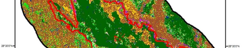
Figure 2. Land-use/ Land-cover of DNP.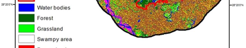
American Journal of Remote Sensing 2018; 6(1): 52-58 55
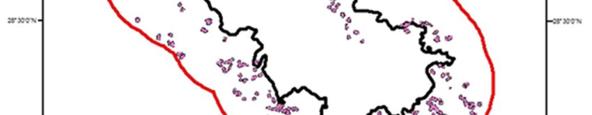
Figure 3. Water Bodies Buffer (100m), DNP.
Figure 4. Road Buffer (100m), DNP.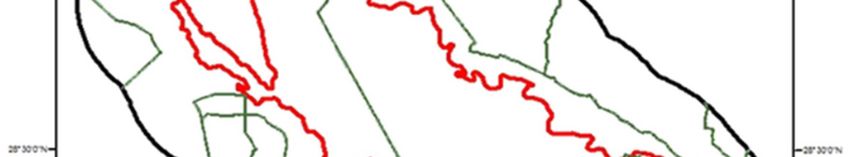
56 Suneet Naithani et al.: Habitat Suitability Analysis for Swamp Deer (Rucervus Duvaucelii) Using
Geo-Spatial Tools in Dudhwa National Park
Figure 5. Settlement Buffer (100 m), DNP.
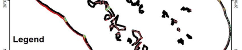
Figure 6. Habitat suitability, Swamp Deer, DNP.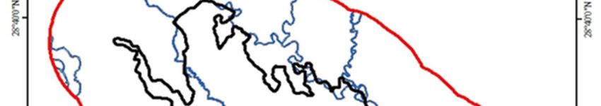
American Journal of Remote Sensing 2018; 6(1): 52-58                                           57

   The variables used to calculate the habitat suitability of      Mayank Srivastava and Mr. Ranjeet Singh Bisht, WWF-India
elephants were; vegetation cover (Figure 2), water bodies          for their valuable information and guidance.
(Figure 3), roads (Figure 4), settlements (Figure 5) and habitat
suitability map (Figure 6) is a scale over which habitat using
various variables were evaluated. These were used to predict       References
occurrence of the species by the environmental factors that can
affect them. Habitat suitability was done by weightage given to    [1]   Duckworth, J. W., et al., Rucervus duvaucelii. The IUCN Red
                                                                         List of Threatened Species 2015:e.
them in the form of percentage.                                          T4257A22167675.http://dx.doi.org/10.2305/IUCN.UK.20154.
   Result indicates that out of total geographical area of the           RLTS.T4257A22167675.en.15 May 2018
park approximately 2.000000-2.100000 (20-21%) is highly
suitable for the animal species, 1.900000 (19%) is suitable,       [2]   Naithani, S., V. B. Mathur and C. Jeganathan, Habitat
                                                                         characterization of Western Tragopan (Tragopan
1.800000 (18%) moderately suitable, 1.700000 (17%) less                  melanocephalus), Great Himalayan national park, India.
suitable and 1.500000-1.600000 (15-16%) area is least                    International Journal of Zoology Studies, 2018. 3(2): p. 46-53.
suitable. The variables were weighted according to the
suitability of swamp deer, which was 50% on grasslands,            [3]   Naithani, S., and V. B. Mathur, Musk Deer (Moschus
                                                                         chrysogaster) Habitat modeling in Great Himalayan national
30% on water bodies, 10% on roads and 10% on settlement                  park conservation area. In: Naithani, S. and Jeganathan, C.
of the area.                                                             (Eds.), Remote Sensing and GIS in Environmental Resource
   Habitat estimation of wild species in an area is                      Management, Gaura Books India Pvt. Ltd, New Delhi, book.
fundamental to understand its demography and status and to               2014. p. 69-82.
plan for species management and conservation along with the        [4]   Areendran, G., et al., Geospatial modeling to assess elephant
area [17]. Several other workers have done the studies on                habitat suitability and corridors in northern Chattisgarh, India.
habitat suitability models and analysis for different species in         Tropical Ecology, 2011. 52(3): p. 275-283.
different protected and conservation areas [18-21].
                                                                   [5]   Kushwaha, S. P. S., and P. S. Roy., Geospatial technology for
Improvements can be done by effective efforts to conserve                wildlife habitat evaluation. Tropical Ecology, 2002. 43(1): p.
the grassland, forest and water bodies by park authorities               137-150.
with participatory approach in and around the DNP is needed
to protect the food and feeding sites of Swamp deer                [6]   Nandy, S., S. P. S. Kushwaha and P. Gaur, Identification of
                                                                         Swamp Deer (Cervus duvauceli duvauceli Cuvier) potential
(Rucervus duvaucelii).                                                   habitat in Jhilmil Jheel Conservation Reserve, Uttarakhand,
                                                                         India    using    multi-criteria  analysis.  Environmental
5. Conclusion                                                            Management, 2012. 49(4): p. 902-14.
                                                                   [7]   Sarma, P. K., et al., Evaluation of habitat suitability for Rhino
   The study revealed the potentiality of RS and GIS as tools            (Rhinoceros unicornis) in Orang National Park using Geo-
for analyzing the habitat suitability. The elements;                     spatial tools. ISRN Ecology, 2011. 2011: p. 9.
grasslands, water bodies, settlements and roads highly affect
the swamp deer species in DNP. It was found that 2.0- 2.1          [8]   Debeljak, M., et al., Habitat suitability modeling for Red Deer
                                                                         (Cervus elaphus L.) in South-central Slovenia with
(20-21%) areas is highly suitable for the Swamp deer.                    classification trees. Ecological Modeling, 2001. 138: p. 321-
Comparing the NDVI and the NDWI data of two different                    330.
years depicts a change in grassland and forest cover as well
as water bodies declined to an extent due to environmental         [9]   Imam, E., and S. P. S. Kushwaha, Habitat suitability modeling
                                                                         for Gaur (Bosgaurus) using multiple logistic regression,
problems and human interventions will lead towards decline               remote sensing and GIS. Journal of Applied Animal Research,
of the population of Swamp dear and their suitable habitat.              2013. 41(2); p. 189-199.
There should also be quick responses towards illegal
activities like hunting and poaching along with solution on        [10] Aini, S., Sood, A. M. and S. Saaban, Analyzing elephant
                                                                        habitat parameters using GIS, Remote Sensing and analytic
human wildlife conflicts. The infant results can be used for            hierarchy process in Peninsula Malaysia. Pertanika J. Sci.
the further study for the conservation of Swamp deer species            &Technol, 2015. 23 (1): p. 37-50.
as well as for the habitat conservation by wildlife managers.
                                                                   [11] Iqbal, M. Z., and M. J. Iqbal, Land use detection using
                                                                        Remote Sensing and GIS (acase study of Rawalpindi
Acknowledgements                                                        division). American Journal of Remote Sensing, 2018. 6 (1):
                                                                        p. 39-51.
   We are sincerely thank to all those who have helped us
throughout this study. We would like to thank Secretary            [12] Xu, D., and X. Guo, Compare NDVI Extracted from Landsat
                                                                        8 imagery with that from Landsat 7 imagery. American
General & CEO, WWF-India and Programme Director,                        Journal of Remote Sensing, 2014. 2 (2): p. 10-14.
WWF-India, for allowing us to carry out our study. We also
express our gratefulness to Dr. Krishna Raj, Mr. Mohit             [13] Sanare, J. E., E. S. Ganawa and A. M. S. Abdelrahim, Wildlife
Sharma and Ms. Tanushree Mukherjee, WWF-India, Mr.                      habitat suitability analysis at Serengeti National Park (SNP),
                                                                        Tanzania case study Loxodonta sp. Journal of Ecosys
Rajeev Kumar, Mr. Sandeep Kumar, ENVIS Centre, Mr.                      Ecograph, 2015. 5: p. 164.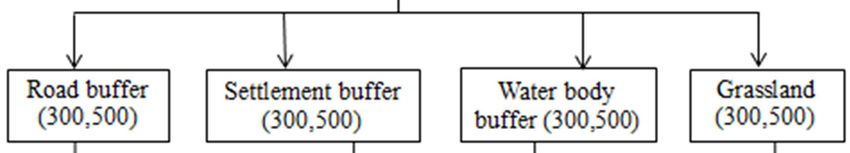
58                   Suneet Naithani et al.: Habitat Suitability Analysis for Swamp Deer (Rucervus Duvaucelii) Using
                                               Geo-Spatial Tools in Dudhwa National Park

[14] Buruso, F. H., Habitat suitability analysis for hippopotamus     [18] Kumar, P., P. M. Hais and P. Kindlmann, Habitat suitability
     (H. amphibious) using GIS and remote sensing in Lake Tana             models of mountain ungulates, identifying potential areas for
     and its environs, Ethiopia. Environmental Systems Research,           conservation. Zoological Studies, 2015. p. 54:37.
     2018. 6:p 6.
                                                                      [19] Thapa, T. B., Habitat Suitability Evaluation for Leopard Using
[15] Thapa, V., M. F. Acevedo and K. P. Limbu, An analysis of the          Remote Sensing and GIS in and Around Chitwan National
     habitat of the Greater One-horned Rhinoceros Rhinoceros               Park, Nepal. Ph. D. thesis, Saurashtra University, 2011. p. 1-
     unicornis (Mammalia: Perissodactyla: Rhinocerotidae) at the           223.
     Chitwan National Park, Nepal. Journal of Threatened Taxa,
     2014. 6(10): p. 6313–6325.                                       [20] Sampson, A. M., A habitat suitability analysis for cougar
                                                                           (Puma concolor) in Minnesota. Retrieved, the University of
[16] Tiwari, R., and G. S. Rawat, Assessment of Swamp Deer                 Minnesota Digital Conservancy, 2013.
     habitat in and Around Jhilmil Jheel conservation reserve,             http://hdl.handle.net/11299/162392
     Haridwar, Uttarakhand, India. International Journal of
     Conservation Science, 2013. 4: p. 243-249.                       [21] Morrigan, E., Habitat Suitability Analysis of the Coast Horned
                                                                           Lizard (Phrynosoma coronatum Blainvillii) in the Santa
[17] Varman, S. K., and R. Sukumar, The line transects method for          Monica Mountain National Recreation Area. Book,
     estimating densities of large mammals in a tropical deciduous         https://books.google.co.in/books?id=DzC2ngEACAAJ, 2013.
     forest: An evaluation of models and field experiments. Journal        p. 112.
     of Biosciences, 1995. 20 (2): p. 273-287.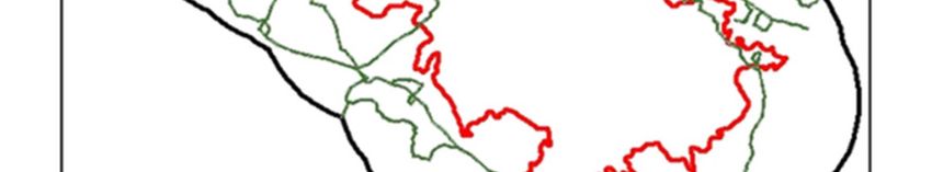
You can also read